
Geography of Belgium
Encyclopedia
Belgium
is a federal state located in Western Europe
, bordering the North Sea
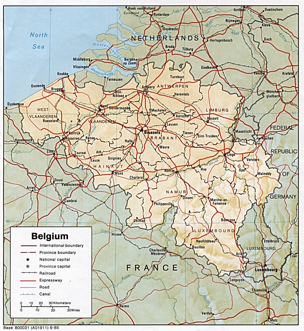
. Belgium shares borders with France
(620 km), Germany
(167 km), Luxembourg
(148 km) and the Netherlands
(450 km). Belgium comprises the regions of Flanders
, Wallonia and Brussels.
Freshwater withdrawal (domestic/industrial/agricultural):
total: 7.44 cu km/yr (13%/85%/1%)
per capita: 714 cu m/yr (1998)
Natural hazards:
flooding is a threat in areas of reclaimed coastal land, protected from the sea by concrete dikes
Geography - note:
crossroads of Western Europe; majority of West European capitals within 1,000 km of Brussels which is the seat of both the EU and NATO
Longest Distances: 280 km SE-NW/ 222 km NE-SW
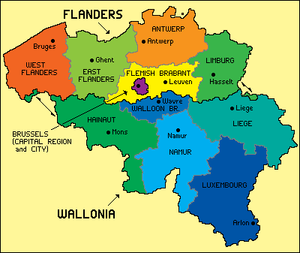 Belgium has an area of 30,528 square kilometres, with 16,844 square kilometres for Wallonia, 13,522 square kilometres for Flanders
and 161 square kilometres for the Brussels Capital Region. By provinces, the area is distributed as such:
To get the total area of Belgium, the surface of the Brussels-Capital Region should be added to the list, since Brussels is not in any Belgian province anymore since the province of Brabant has been split. Belgium has also 3,462 square kilometres of sea territories in the North Sea
. On 29 May 2000, 2,000 square metres were granted by the Netherlands
to Belgium (a piece of land in Zelzate
along the Ghent-Terneuzen Canal
).
Compared to other countries, Belgium is 1.5 times larger than Wales
in the United Kingdom
and about the size of Maryland
in the United States
. Belgium is actually used as an unusual unit of measurement in comparing country sizes.

 Belgium has three main geographical regions: the coastal plain in the north-west, the central plateau, and the Ardennes
uplands in the south-east. The coastal plain consists mainly of sand dunes and polder
s. Polders are areas of land, close to or below sea level that have been reclaimed from the sea, from which they are protected by dikes or, further inland, by fields that have been drained with canals. The second geographical region, the central plateau, lies further inland. This is a smooth, slowly rising area that has many fertile valleys and is irrigated by many waterways. Here one can also find rougher land, including caves and small gorges. The third geographical region, called the Ardennes, is more rugged than the first two. It is a thickly forested plateau, very rocky and not very good for farming, which extends into northern France and in Germany where it is named Eifel
. This is where much of Belgium's wildlife can be found. Belgium's highest point, the Signal de Botrange
is located in this region at only 694 metres (2,277 ft). Belgium has relatively few natural lakes, and none of any great size.
Notable natural regions include the Ardennes, Campine
and High Fens
.
, except the municipality of Momignies
(Macquenoise), which is drained by the Oise river
into the English Channel
. A total of 3 streams cross Belgium: the Scheldt
(200 km in Belgium, 350 km in total), the Meuse
(183 km in Belgium, 925 km in total) and the Yser
(50 km in Belgium, 78 km in total). The main rivers in Belgium include the Rupel
, Senne
, Sambre
, Lesse
, Ourthe
, Lys
and Dijle
. The main lakes include the Lake Genval
, Lake Bütgenbach
, Lake Eau d'Heure
and Lake Robertville
.
, the Brussels-Charleroi Canal
, the Canal du Centre
and the Albert Canal
.
, with significant precipitation in all seasons (Köppen climate classification
: Cfb; the average temperature is 3 °C (37.4 °F) in January, and 18 °C (64.4 °F) in July; the average precipitation is 65 mm (2.6 in) in January, and 78 mm (3.1 in) in July). Belgium has mild winters and cool summers and is rainy, humid and cloudy.
at 694 metres above the sea level. Other hills in Belgium include the Kemmelberg
(159 m high) and the Koppenberg
(77 m high) both known as being climbed by professional cyclist during the annual cycling road races of respectively Gent–Wevelgem and the Tour of Flanders
.
 This is a list of the extreme points of Belgium, the points that are farther north, south, east or west than any other location.
The Belgian National Geographic Institute
calculated that the central point of Belgium lies at coordinates 50°38′28"N 4°40′05"E, in Nil-Saint-Vincent-Saint-Martin
in the municipality of Walhain
.
s. Belgium used to have coal mines. As of 2007, the land use was as follows:
As of 2003, the estimated area of irrigated land was of 400 km².
. A 2003 report suggested that the water in Belgium's rivers was of the lowest quality in Europe, and bottom of the 122 countries studied. The environment is exposed to intense pressures from human activities: urbanization, dense transportation network, industry, extensive animal breeding and crop cultivation; air and water pollution also have repercussions for neighboring countries; uncertainties regarding federal and regional responsibilities (now resolved) have slowed progress in tackling environmental challenges.
, Antwerp, Ghent
, Charleroi
and Liège. Other notable cities include Bruges
, Namur
, Leuven
, Mons
and Mechelen
.
Belgium
Belgium , officially the Kingdom of Belgium, is a federal state in Western Europe. It is a founding member of the European Union and hosts the EU's headquarters, and those of several other major international organisations such as NATO.Belgium is also a member of, or affiliated to, many...
is a federal state located in Western Europe
Western Europe
Western Europe is a loose term for the collection of countries in the western most region of the European continents, though this definition is context-dependent and carries cultural and political connotations. One definition describes Western Europe as a geographic entity—the region lying in the...
, bordering the North Sea
North Sea
In the southwest, beyond the Straits of Dover, the North Sea becomes the English Channel connecting to the Atlantic Ocean. In the east, it connects to the Baltic Sea via the Skagerrak and Kattegat, narrow straits that separate Denmark from Norway and Sweden respectively...
. Belgium shares borders with France
France
The French Republic , The French Republic , The French Republic , (commonly known as France , is a unitary semi-presidential republic in Western Europe with several overseas territories and islands located on other continents and in the Indian, Pacific, and Atlantic oceans. Metropolitan France...
(620 km), Germany
Germany
Germany , officially the Federal Republic of Germany , is a federal parliamentary republic in Europe. The country consists of 16 states while the capital and largest city is Berlin. Germany covers an area of 357,021 km2 and has a largely temperate seasonal climate...
(167 km), Luxembourg
Luxembourg
Luxembourg , officially the Grand Duchy of Luxembourg , is a landlocked country in western Europe, bordered by Belgium, France, and Germany. It has two principal regions: the Oesling in the North as part of the Ardennes massif, and the Gutland in the south...
(148 km) and the Netherlands
Netherlands
The Netherlands is a constituent country of the Kingdom of the Netherlands, located mainly in North-West Europe and with several islands in the Caribbean. Mainland Netherlands borders the North Sea to the north and west, Belgium to the south, and Germany to the east, and shares maritime borders...
(450 km). Belgium comprises the regions of Flanders
Flanders
Flanders is the community of the Flemings but also one of the institutions in Belgium, and a geographical region located in parts of present-day Belgium, France and the Netherlands. "Flanders" can also refer to the northern part of Belgium that contains Brussels, Bruges, Ghent and Antwerp...
, Wallonia and Brussels.
General information
Total renewable water resources: 20.8 cu km (2005)Freshwater withdrawal (domestic/industrial/agricultural):
total: 7.44 cu km/yr (13%/85%/1%)
per capita: 714 cu m/yr (1998)
Natural hazards:
flooding is a threat in areas of reclaimed coastal land, protected from the sea by concrete dikes
Geography - note:
crossroads of Western Europe; majority of West European capitals within 1,000 km of Brussels which is the seat of both the EU and NATO
Longest Distances: 280 km SE-NW/ 222 km NE-SW
Area
Flanders
Flanders is the community of the Flemings but also one of the institutions in Belgium, and a geographical region located in parts of present-day Belgium, France and the Netherlands. "Flanders" can also refer to the northern part of Belgium that contains Brussels, Bruges, Ghent and Antwerp...
and 161 square kilometres for the Brussels Capital Region. By provinces, the area is distributed as such:
- LuxembourgLuxembourg (Belgium)Luxembourg is the southernmost province of Wallonia and of Belgium. It borders on the Grand Duchy of Luxembourg, France, and the Belgian provinces of Namur and Liège. Its capital is Arlon, in the south-east of the province.It has an area of 4,443 km², making it the largest Belgian province...
: 4,440 km² - LiègeLiège (province)Liège is the easternmost province of Belgium and belongs to the Walloon Region. It is an area of French and German ethnicity. It borders on the Netherlands, Germany, Luxembourg, and in Belgium the provinces of Luxembourg, Namur, Walloon Brabant , and those of Flemish Brabant and Limburg . Its...
: 3,862 km² - Hainaut: 3,786 km²
- NamurNamur (province)Namur is a province of Wallonia, one of the three regions of Belgium. It borders on the Walloon provinces of Hainaut, Walloon Brabant, Liège and Luxembourg in Belgium, and on France. Its capital is the city of Namur...
: 3,666 km² - West Flanders: 3,144 km²
- East FlandersEast FlandersEast Flanders is a province of Flanders, one of the three regions of Belgium. It borders on the Netherlands and in Belgium on the provinces of Antwerp, Flemish Brabant , of Hainaut and of West Flanders...
: 2,982 km² - AntwerpAntwerp (province)Antwerp is the northernmost province both of the Flemish Region, also called Flanders, and of Belgium. It borders on the Netherlands and the Belgian provinces of Limburg, Flemish Brabant and East Flanders. Its capital is Antwerp which comprises the Port of Antwerp...
: 2,867 km² - LimburgLimburg (Belgium)Limburg is the easternmost province of modern Flanders, which is one of the three main political and cultural sub-divisions of modern Belgium. It is located west of the river Meuse . It borders on the Dutch provinces of North Brabant and Limburg and the Belgian provinces of Liège, Flemish Brabant...
: 2,422 km² - Flemish BrabantFlemish BrabantFlemish Brabant is a province of Flanders, one of the three regions of Belgium. It borders on the Belgian provinces of Antwerp, Limburg, Liège, Walloon Brabant, Hainaut and East Flanders. Flemish Brabant also completely surrounds the Brussels-Capital Region. Its capital is Leuven...
: 2,106 km² - Walloon BrabantWalloon BrabantWalloon Brabant is a province of Wallonia in Belgium. It borders on the province of Flemish Brabant and the provinces of Liège, Namur and Hainaut . Its capital is Wavre...
: 1,091 km²
To get the total area of Belgium, the surface of the Brussels-Capital Region should be added to the list, since Brussels is not in any Belgian province anymore since the province of Brabant has been split. Belgium has also 3,462 square kilometres of sea territories in the North Sea
North Sea
In the southwest, beyond the Straits of Dover, the North Sea becomes the English Channel connecting to the Atlantic Ocean. In the east, it connects to the Baltic Sea via the Skagerrak and Kattegat, narrow straits that separate Denmark from Norway and Sweden respectively...
. On 29 May 2000, 2,000 square metres were granted by the Netherlands
Netherlands
The Netherlands is a constituent country of the Kingdom of the Netherlands, located mainly in North-West Europe and with several islands in the Caribbean. Mainland Netherlands borders the North Sea to the north and west, Belgium to the south, and Germany to the east, and shares maritime borders...
to Belgium (a piece of land in Zelzate
Zelzate
Zelzate is a municipality located in the Belgian province of East Flanders. The municipality only comprises the town of Zelzate proper. On January 1, 2006 Zelzate had a total population of 12,176. The total area is 13.71 km² which gives a population density of 888 inhabitants per km².Zelzate is...
along the Ghent-Terneuzen Canal
Ghent-Terneuzen Canal
The Ghent-Terneuzen Canal , also known as the "Sea Canal" is a canal linking Ghent in Belgium to the port of Terneuzen on the Westerschelde estuary in the Netherlands, thereby providing the former with better access to the sea.-History:The canal was constructed between 1823 and 1827 on the...
).
Compared to other countries, Belgium is 1.5 times larger than Wales
Wales
Wales is a country that is part of the United Kingdom and the island of Great Britain, bordered by England to its east and the Atlantic Ocean and Irish Sea to its west. It has a population of three million, and a total area of 20,779 km²...
in the United Kingdom
United Kingdom
The United Kingdom of Great Britain and Northern IrelandIn the United Kingdom and Dependencies, other languages have been officially recognised as legitimate autochthonous languages under the European Charter for Regional or Minority Languages...
and about the size of Maryland
Maryland
Maryland is a U.S. state located in the Mid Atlantic region of the United States, bordering Virginia, West Virginia, and the District of Columbia to its south and west; Pennsylvania to its north; and Delaware to its east...
in the United States
United States
The United States of America is a federal constitutional republic comprising fifty states and a federal district...
. Belgium is actually used as an unusual unit of measurement in comparing country sizes.
Physical geography
Ardennes
The Ardennes is a region of extensive forests, rolling hills and ridges formed within the Givetian Ardennes mountain range, primarily in Belgium and Luxembourg, but stretching into France , and geologically into the Eifel...
uplands in the south-east. The coastal plain consists mainly of sand dunes and polder
Polder
A polder is a low-lying tract of land enclosed by embankments known as dikes, that forms an artificial hydrological entity, meaning it has no connection with outside water other than through manually-operated devices...
s. Polders are areas of land, close to or below sea level that have been reclaimed from the sea, from which they are protected by dikes or, further inland, by fields that have been drained with canals. The second geographical region, the central plateau, lies further inland. This is a smooth, slowly rising area that has many fertile valleys and is irrigated by many waterways. Here one can also find rougher land, including caves and small gorges. The third geographical region, called the Ardennes, is more rugged than the first two. It is a thickly forested plateau, very rocky and not very good for farming, which extends into northern France and in Germany where it is named Eifel
Eifel
The Eifel is a low mountain range in western Germany and eastern Belgium. It occupies parts of southwestern North Rhine-Westphalia, northwestern Rhineland-Palatinate and the south of the German-speaking Community of Belgium....
. This is where much of Belgium's wildlife can be found. Belgium's highest point, the Signal de Botrange
Signal de Botrange
The Signal de Botrange is the highest point in Belgium, located in the High Fens , at . It is the top of a broad plateau, and a road crosses the summit, passing an adjacent café. In 1923, the six-metre-high Baltia tower was built on the summit to allow visitors to reach an altitude of 700 m...
is located in this region at only 694 metres (2,277 ft). Belgium has relatively few natural lakes, and none of any great size.
Notable natural regions include the Ardennes, Campine
Campine
The Campine is a natural region situated chiefly in north-eastern Belgium and parts of the south-western Netherlands which once consisted mainly of extensive moors, tracts of sandy heath, and wetlands...
and High Fens
High Fens
The High Fens , which were declared a nature reserve in 1957, are an upland area, a plateau region in the province of Liège, in the east of Belgium and nearby parts of Germany, lying between the Ardennes and the Eifel highlands. It is the largest nature reserve or park in Belgium, with an area of ;...
.
Rivers and lakes
All of Belgium is drained into the North SeaNorth Sea
In the southwest, beyond the Straits of Dover, the North Sea becomes the English Channel connecting to the Atlantic Ocean. In the east, it connects to the Baltic Sea via the Skagerrak and Kattegat, narrow straits that separate Denmark from Norway and Sweden respectively...
, except the municipality of Momignies
Momignies
Momignies is a Walloon municipality in the Belgian province of Hainaut. On January 1, 2006 Momignies had a total population of 5,125. The total area is 85.58 km² which gives a population density of 60 inhabitants per km²....
(Macquenoise), which is drained by the Oise river
Oise River
The River Oise is a right tributary of the River Seine, flowing for 302 km in Belgium and France. Its source is in the Belgian province Hainaut, south of the town Chimay. It crosses the border with France after about 20 km. It flows into the Seine in Conflans-Sainte-Honorine, near Paris...
into the English Channel
English Channel
The English Channel , often referred to simply as the Channel, is an arm of the Atlantic Ocean that separates southern England from northern France, and joins the North Sea to the Atlantic. It is about long and varies in width from at its widest to in the Strait of Dover...
. A total of 3 streams cross Belgium: the Scheldt
Scheldt
The Scheldt is a 350 km long river in northern France, western Belgium and the southwestern part of the Netherlands...
(200 km in Belgium, 350 km in total), the Meuse
Meuse River
The Maas or Meuse is a major European river, rising in France and flowing through Belgium and the Netherlands before draining into the North Sea...
(183 km in Belgium, 925 km in total) and the Yser
Yser
The Yser is a river that finds its origin in the north of France, enters Belgium and flows into the North Sea at the town of Nieuwpoort.-In France:The source of the Yser is in Buysscheure, in the Nord département of northern France...
(50 km in Belgium, 78 km in total). The main rivers in Belgium include the Rupel
Rupel
The Rupel is a tidal river in northern Belgium, right tributary of the Scheldt. It is about 12 km long. It flows through the Belgian province Antwerp. It is formed by the confluence of the rivers Dijle and Nete, in Rumst. It flows into the Scheldt at Rupelmonde. Towns along the Rupel are...
, Senne
Senné
Senné is a village and municipality in the Veľký Krtíš District of the Banská Bystrica Region of southern Slovakia.-External links:*http://www.statistics.sk/mosmis/eng/run.html...
, Sambre
Sambre
The Sambre is a river in northern France and Wallonia, southern Belgium, left tributary of the Meuse River. The ancient Romans called the river Sabis.-Course:...
, Lesse
Lesse
The Lesse is a river in the Ardennes, in the Walloon region of Belgium. It is a right tributary to the river Meuse.The source of the Lesse is near Libramont-Chevigny, in the Belgian province of Luxembourg. The Lesse flows roughly in north-western direction. Near Han-sur-Lesse the entire river goes...
, Ourthe
Ourthe
The Ourthe is a 165 km long river in the Ardennes in Wallonia . It is a right tributary to the river Meuse. The Ourthe is formed at the confluence of the Ourthe Occidentale and the Ourthe Orientale , west of Houffalize.The source of the Ourthe Occidentale is near Libramont-Chevigny, in the...
, Lys
Lys
Lys may refer to any of the following:Places*The Lys or Leie, a river in France and Belgium*Lys , a stream of Aosta Valley in Italy*Lys, Pyrénées-Atlantiques, a commune in the Pyrénées-Atlantiques department in France...
and Dijle
Dijle
Dyle or Dijle or historically the River Dyle in English, is a river in central Belgium, left tributary of the Rupel. It is long. It flows through the Belgian provinces of Walloon Brabant, Flemish Brabant and Antwerp...
. The main lakes include the Lake Genval
Lake Genval
Lake Genval is a lake located in Belgium in the south-east of Brussels near the Sonian Forest in the municipalities of Rixensart in Wallonia and Overijse in Flanders. The river of the lake is named Silver river. The lake is a great leisure place for the people of Brussels...
, Lake Bütgenbach
Lake Bütgenbach
Lake Bütgenbach is an artificial lake created by the damming of the Warche river in 1932. It is located near the village of Bütgenbach in Ardennes , Belgium. The lake is not far from the border of Germany....
, Lake Eau d'Heure
Lake Eau d'Heure
The Lake Eau d'Heure is the most important artificial lake in Belgium. Its dams were built during the seventies. The lake is not far from the village of Cerfontaine and the border with France. The river of the lake is the Eau d'Heure River...
and Lake Robertville
Lake Robertville
Lake Robertville is an artificial lake near the city of Malmedy in Belgium. The water volume is 8,000,000 m³ and the area is 0,62 km². The lake is located in the High Fens park. The dam on the river Warche was built in 1928....
.
Artificial waterways
Belgium has also many artificial waterways or canals, among others the Brussels-Scheldt Maritime CanalBrussels-Scheldt Maritime Canal
The Brussels–Scheldt Maritime Canal, also named the Willebroek Canal, is a canal in Belgium linking Brussels with the river Scheldt. The canal was known as the Brussels-Rupel Maritime Canal, prior to the establishment of a direct link with the Scheldt in 1997.The canal is one of the oldest...
, the Brussels-Charleroi Canal
Brussels-Charleroi Canal
The Brussels–Charleroi Canal, also known as the Charleroi Canal amongst other similar names, is an important canal in Belgium. The canal is quite large, with a Class IV Freycinet gauge, and its Wallonian portion is long. It runs from Charleroi in the south to Brussels in the north...
, the Canal du Centre
Canal du Centre (Belgium)
The Canal du Centre is a canal in Belgium, which, with other canals, links the waterways of the Meuse and Scheldt rivers. It has a total length of 20.9 km. It connects the artificial lake Grand Large near Nimy, with the Brussels-Charleroi Canal near Seneffe....
and the Albert Canal
Albert Canal
The Albert Canal is a canal located in northeastern Belgium, named after King Albert I of Belgium. It connects the major cities Antwerp and Liège and the Meuse and Scheldt rivers. It has a depth of , a free height of and a total length of...
.
Climate
The Belgian climate, like most of northwest Europe, is maritime temperateTemperate
In geography, temperate or tepid latitudes of the globe lie between the tropics and the polar circles. The changes in these regions between summer and winter are generally relatively moderate, rather than extreme hot or cold...
, with significant precipitation in all seasons (Köppen climate classification
Köppen climate classification
The Köppen climate classification is one of the most widely used climate classification systems. It was first published by Crimea German climatologist Wladimir Köppen in 1884, with several later modifications by Köppen himself, notably in 1918 and 1936...
: Cfb; the average temperature is 3 °C (37.4 °F) in January, and 18 °C (64.4 °F) in July; the average precipitation is 65 mm (2.6 in) in January, and 78 mm (3.1 in) in July). Belgium has mild winters and cool summers and is rainy, humid and cloudy.
Mountain and hills
Belgium's highest point is the Signal de BotrangeSignal de Botrange
The Signal de Botrange is the highest point in Belgium, located in the High Fens , at . It is the top of a broad plateau, and a road crosses the summit, passing an adjacent café. In 1923, the six-metre-high Baltia tower was built on the summit to allow visitors to reach an altitude of 700 m...
at 694 metres above the sea level. Other hills in Belgium include the Kemmelberg
Kemmelberg
The Kemmelberg, also known as Kemmel Hill or Mont Kemmel, is a 156m high hill near Kemmel in the municipality of Heuvelland in West Flanders, Belgium....
(159 m high) and the Koppenberg
Koppenberg
Koppenberg is a high hill in Oudenaarde, the Flemish Ardennes, Belgium...
(77 m high) both known as being climbed by professional cyclist during the annual cycling road races of respectively Gent–Wevelgem and the Tour of Flanders
Tour of Flanders
The Tour of Flanders is a Flanders Classics road cycling race held in Belgium every spring, a week before the Paris–Roubaix road race. It is part of the UCI World Tour and one of the so-called monuments of the European professional calendar. It is the most important cycling race in Flanders...
.
Extreme points
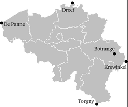
- Northernmost point — Dreef, municipality of HoogstratenHoogstratenHoogstraten is a municipality located in the Belgian province of Antwerp. The municipality comprises the city of Hoogstraten proper and the towns of Meer, Meerle, Meersel-Dreef, Minderhout and Wortel,...
, AntwerpAntwerp (province)Antwerp is the northernmost province both of the Flemish Region, also called Flanders, and of Belgium. It borders on the Netherlands and the Belgian provinces of Limburg, Flemish Brabant and East Flanders. Its capital is Antwerp which comprises the Port of Antwerp... - Southernmost point — Torgny, municipality of RouvroyRouvroy, BelgiumRouvroy is a Walloon municipality of Belgium located in the province of Luxembourg.On 1 January 2007 the municipality, which covers 27.68 km², had 2,007 inhabitants, giving a population density of 72.5 inhabitants per km²....
, Luxembourg - Westernmost point — De PanneDe PanneDe Panne is a municipality located along the North Sea coast of the Belgian province of West Flanders. The municipality comprises the towns of Adinkerke and De Panne proper. On 1 January 2006 De Panne had a total population of 10,060. The total area is 23.90 km² which gives a population...
, West Flanders - Easternmost point — Krewinkel, municipality of BüllingenBüllingenBüllingen is a largely German language-speaking municipality located in the Belgian province of Liège. On January 1, 2006 Büllingen had a total population of 5,385. The total area is 150.49 km² which gives a population density of 36 inhabitants per km²....
, LiègeLiège (province)Liège is the easternmost province of Belgium and belongs to the Walloon Region. It is an area of French and German ethnicity. It borders on the Netherlands, Germany, Luxembourg, and in Belgium the provinces of Luxembourg, Namur, Walloon Brabant , and those of Flemish Brabant and Limburg . Its...
- Highest point — Signal de BotrangeSignal de BotrangeThe Signal de Botrange is the highest point in Belgium, located in the High Fens , at . It is the top of a broad plateau, and a road crosses the summit, passing an adjacent café. In 1923, the six-metre-high Baltia tower was built on the summit to allow visitors to reach an altitude of 700 m...
(694 m) - Lowest point — De Moeren (-3 m)
The Belgian National Geographic Institute
Belgian National Geographic Institute
The Belgian National Geographic Institute is the national mapping agency in Belgium.The headquarters are located at La Cambre Abbey in Brussels....
calculated that the central point of Belgium lies at coordinates 50°38′28"N 4°40′05"E, in Nil-Saint-Vincent-Saint-Martin
Nil-Saint-Vincent-Saint-Martin
Nil-Saint-Vincent-Saint-Martin is a former municipality in the province of Walloon Brabant, Belgium. In 1976 it became part of the municipality of Walhain.The villages of Nil-Saint-Vincent and Nil-Saint-Martin were merged in 1812...
in the municipality of Walhain
Walhain
Walhain is a Walloon municipality of Belgium located in the province of Walloon Brabant. It consists of the former municipalities of Nil-Saint-Vincent-Saint-Martin, Tourinnes-Saint-Lambert and Walhain-Saint-Paul....
.
Natural resources
Natural resources in Belgium include construction materials, silica sand and carbonateCarbonate
In chemistry, a carbonate is a salt of carbonic acid, characterized by the presence of the carbonate ion, . The name may also mean an ester of carbonic acid, an organic compound containing the carbonate group C2....
s. Belgium used to have coal mines. As of 2007, the land use was as follows:
- Arable landArable landIn geography and agriculture, arable land is land that can be used for growing crops. It includes all land under temporary crops , temporary meadows for mowing or pasture, land under market and kitchen gardens and land temporarily fallow...
: 27.42% - Permanent cropPermanent cropA permanent crop is one produced from plants which last for many seasons, rather than being replanted after each harvest.As used in The World Factbook land use statistics the term comprises land cultivated for crops like citrus, olives, coffee, and rubber; it includes land under flowering shrubs,...
s: 0.69% - OtherOtherThe Other or Constitutive Other is a key concept in continental philosophy; it opposes the Same. The Other refers, or attempts to refer, to that which is Other than the initial concept being considered...
: 71.89%
As of 2003, the estimated area of irrigated land was of 400 km².
Environment
Because of its high population density and location in the centre of Western Europe, Belgium faces serious environmental problemsEnvironment of Belgium
The environment of Belgium is affected by the high population density in most of the country. Water quality suffers from a relatively low percentage of sewage wastewater treatment and from historical pollution accumulated in sediments. Air quality is affected by emissions from traffic and house...
. A 2003 report suggested that the water in Belgium's rivers was of the lowest quality in Europe, and bottom of the 122 countries studied. The environment is exposed to intense pressures from human activities: urbanization, dense transportation network, industry, extensive animal breeding and crop cultivation; air and water pollution also have repercussions for neighboring countries; uncertainties regarding federal and regional responsibilities (now resolved) have slowed progress in tackling environmental challenges.
Cities
The main cities in Belgium in terms of population are BrusselsBrussels
Brussels , officially the Brussels Region or Brussels-Capital Region , is the capital of Belgium and the de facto capital of the European Union...
, Antwerp, Ghent
Ghent
Ghent is a city and a municipality located in the Flemish region of Belgium. It is the capital and biggest city of the East Flanders province. The city started as a settlement at the confluence of the Rivers Scheldt and Lys and in the Middle Ages became one of the largest and richest cities of...
, Charleroi
Charleroi
Charleroi is a city and a municipality of Wallonia, located in the province of Hainaut, Belgium. , the total population of Charleroi was 201,593. The metropolitan area, including the outer commuter zone, covers an area of and had a total population of 522,522 as of 1 January 2008, ranking it as...
and Liège. Other notable cities include Bruges
Bruges
Bruges is the capital and largest city of the province of West Flanders in the Flemish Region of Belgium. It is located in the northwest of the country....
, Namur
Namur (city)
Namur is a city and municipality in Wallonia, in southern Belgium. It is both the capital of the province of Namur and of Wallonia....
, Leuven
Leuven
Leuven is the capital of the province of Flemish Brabant in the Flemish Region, Belgium...
, Mons
Mons
Mons is a Walloon city and municipality located in the Belgian province of Hainaut, of which it is the capital. The Mons municipality includes the old communes of Cuesmes, Flénu, Ghlin, Hyon, Nimy, Obourg, Baudour , Jemappes, Ciply, Harmignies, Harveng, Havré, Maisières, Mesvin, Nouvelles,...
and Mechelen
Mechelen
Mechelen Footnote: Mechelen became known in English as 'Mechlin' from which the adjective 'Mechlinian' is derived...
.
External links
- Map of Belgium from lib.utexas.edu