
Geography of Austria
Encyclopedia
| Geography of Austria | |
 |
|
| Continent | Europe Europe Europe is, by convention, one of the world's seven continents. Comprising the westernmost peninsula of Eurasia, Europe is generally 'divided' from Asia to its east by the watershed divides of the Ural and Caucasus Mountains, the Ural River, the Caspian and Black Seas, and the waterways connecting... |
| Region | Central Europe Central Europe Central Europe or alternatively Middle Europe is a region of the European continent lying between the variously defined areas of Eastern and Western Europe... |
| Coordinates | 47°20′N 13°20′E |
| Area | Ranked 120th 83,871 km2 |
| Coastline | 0 km (landlocked) |
| Borders | 2,562 km (Czech Republic Czech Republic The Czech Republic is a landlocked country in Central Europe. The country is bordered by Poland to the northeast, Slovakia to the east, Austria to the south, and Germany to the west and northwest.... 362 km Germany Germany Germany , officially the Federal Republic of Germany , is a federal parliamentary republic in Europe. The country consists of 16 states while the capital and largest city is Berlin. Germany covers an area of 357,021 km2 and has a largely temperate seasonal climate... 784 km Hungary Hungary Hungary , officially the Republic of Hungary , is a landlocked country in Central Europe. It is situated in the Carpathian Basin and is bordered by Slovakia to the north, Ukraine and Romania to the east, Serbia and Croatia to the south, Slovenia to the southwest and Austria to the west. The... 366 km Italy Italy Italy , officially the Italian Republic languages]] under the European Charter for Regional or Minority Languages. In each of these, Italy's official name is as follows:;;;;;;;;), is a unitary parliamentary republic in South-Central Europe. To the north it borders France, Switzerland, Austria and... 430 km Liechtenstein Liechtenstein The Principality of Liechtenstein is a doubly landlocked alpine country in Central Europe, bordered by Switzerland to the west and south and by Austria to the east. Its area is just over , and it has an estimated population of 35,000. Its capital is Vaduz. The biggest town is Schaan... 35 km Slovakia Slovakia The Slovak Republic is a landlocked state in Central Europe. It has a population of over five million and an area of about . Slovakia is bordered by the Czech Republic and Austria to the west, Poland to the north, Ukraine to the east and Hungary to the south... 91 km Slovenia Slovenia Slovenia , officially the Republic of Slovenia , is a country in Central and Southeastern Europe touching the Alps and bordering the Mediterranean. Slovenia borders Italy to the west, Croatia to the south and east, Hungary to the northeast, and Austria to the north, and also has a small portion of... 300 km Switzerland Switzerland Switzerland name of one of the Swiss cantons. ; ; ; or ), in its full name the Swiss Confederation , is a federal republic consisting of 26 cantons, with Bern as the seat of the federal authorities. The country is situated in Western Europe,Or Central Europe depending on the definition.... 164 km) |
| Highest point | Grossglockner 3,798 m |
| Lowest point | Neusiedler See Neusiedler See Lake Neusiedl is the second largest steppe lake in Central Europe, straddling the Austrian–Hungarian border. The lake covers 315 km², of which 240 km² is on the Austrian side and 75 km² on the Hungarian side. The lake's drainage basin has an area of about 1,120 km²... 115 m |
| Longest river | Danube River 2,857 km |
| Largest lake | Neusiedler See 320 km2 |
Austria
Austria
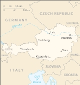
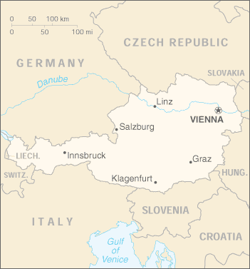
Austria , officially the Republic of Austria , is a landlocked country of roughly 8.4 million people in Central Europe. It is bordered by the Czech Republic and Germany to the north, Slovakia and Hungary to the east, Slovenia and Italy to the south, and Switzerland and Liechtenstein to the...
is a small, predominantly mountainous country in Central Europe
Central Europe
Central Europe or alternatively Middle Europe is a region of the European continent lying between the variously defined areas of Eastern and Western Europe...
, approx. between Germany
Germany
Germany , officially the Federal Republic of Germany , is a federal parliamentary republic in Europe. The country consists of 16 states while the capital and largest city is Berlin. Germany covers an area of 357,021 km2 and has a largely temperate seasonal climate...
, Italy
Italy
Italy , officially the Italian Republic languages]] under the European Charter for Regional or Minority Languages. In each of these, Italy's official name is as follows:;;;;;;;;), is a unitary parliamentary republic in South-Central Europe. To the north it borders France, Switzerland, Austria and...
and Hungary
Hungary
Hungary , officially the Republic of Hungary , is a landlocked country in Central Europe. It is situated in the Carpathian Basin and is bordered by Slovakia to the north, Ukraine and Romania to the east, Serbia and Croatia to the south, Slovenia to the southwest and Austria to the west. The...
. It has a total area of 83,859 km², about twice the size of Switzerland
Switzerland
Switzerland name of one of the Swiss cantons. ; ; ; or ), in its full name the Swiss Confederation , is a federal republic consisting of 26 cantons, with Bern as the seat of the federal authorities. The country is situated in Western Europe,Or Central Europe depending on the definition....
and slightly smaller than the state of Maine
Maine
Maine is a state in the New England region of the northeastern United States, bordered by the Atlantic Ocean to the east and south, New Hampshire to the west, and the Canadian provinces of Quebec to the northwest and New Brunswick to the northeast. Maine is both the northernmost and easternmost...
.
The landlocked country shares national borders with Switzerland (164 km) and the tiny principality of Liechtenstein
Liechtenstein
The Principality of Liechtenstein is a doubly landlocked alpine country in Central Europe, bordered by Switzerland to the west and south and by Austria to the east. Its area is just over , and it has an estimated population of 35,000. Its capital is Vaduz. The biggest town is Schaan...
(35 km) to the west, Germany (784 km) and the Czech Republic
Czech Republic
The Czech Republic is a landlocked country in Central Europe. The country is bordered by Poland to the northeast, Slovakia to the east, Austria to the south, and Germany to the west and northwest....
(362 km) and Slovakia
Slovakia
The Slovak Republic is a landlocked state in Central Europe. It has a population of over five million and an area of about . Slovakia is bordered by the Czech Republic and Austria to the west, Poland to the north, Ukraine to the east and Hungary to the south...
(91 km) to the north, Hungary to the east (346 km), and Slovenia
Slovenia
Slovenia , officially the Republic of Slovenia , is a country in Central and Southeastern Europe touching the Alps and bordering the Mediterranean. Slovenia borders Italy to the west, Croatia to the south and east, Hungary to the northeast, and Austria to the north, and also has a small portion of...
(311 km) and Italy (430 km) to the south (total: 2563 km).
The westernmost third of the somewhat pear-shaped country consists of a narrow corridor between Germany and Italy that is between thirty-two and sixty km wide. The rest of Austria lies to the east and has a maximum north–south width of 280 km. The country measures almost 600 km in length, extending from Lake Constance
Lake Constance
Lake Constance is a lake on the Rhine at the northern foot of the Alps, and consists of three bodies of water: the Obersee , the Untersee , and a connecting stretch of the Rhine, called the Seerhein.The lake is situated in Germany, Switzerland and Austria near the Alps...
(German Bodensee) on the Austrian-Swiss-German border in the west to the Neusiedler See
Neusiedler See
Lake Neusiedl is the second largest steppe lake in Central Europe, straddling the Austrian–Hungarian border. The lake covers 315 km², of which 240 km² is on the Austrian side and 75 km² on the Hungarian side. The lake's drainage basin has an area of about 1,120 km²...
on the Austrian-Hungarian border in the east. The contrast between these two lakes – one in the Alps and the other a typical steppe lake on the westernmost fringe of the Hungarian Plain – illustrates the diversity of Austria's landscape.
Seven of Austria's nine provinces
States of Austria
Austria is a federal republic made up of nine states, known in German as Länder . Since Land is also the German word for a country, the term Bundesländer is often used instead to avoid ambiguity. The Constitution of Austria uses both terms...
have long historical traditions predating the establishment of the Republic of Austria in 1918: Upper Austria
Upper Austria
Upper Austria is one of the nine states or Bundesländer of Austria. Its capital is Linz. Upper Austria borders on Germany and the Czech Republic, as well as on the other Austrian states of Lower Austria, Styria, and Salzburg...
, Lower Austria
Lower Austria
Lower Austria is the northeasternmost state of the nine states in Austria. The capital of Lower Austria since 1986 is Sankt Pölten, the most recently designated capital town in Austria. The capital of Lower Austria had formerly been Vienna, even though Vienna is not officially part of Lower Austria...
, Styria
Styria (state)
Styria is a state or Bundesland, located in the southeast of Austria. In area it is the second largest of the nine Austrian federated states, covering 16,401 km². It borders Slovenia as well as the other Austrian states of Upper Austria, Lower Austria, Salzburg, Burgenland, and Carinthia. ...
, Carinthia
Carinthia (state)
Carinthia is the southernmost Austrian state or Land. Situated within the Eastern Alps it is chiefly noted for its mountains and lakes.The main language is German. Its regional dialects belong to the Southern Austro-Bavarian group...
, Salzburg
Salzburg (state)
Salzburg is a state or Land of Austria with an area of 7,156 km2, located adjacent to the German border. It is also known as Salzburgerland, to distinguish it from its capital city, also named Salzburg...
, Tyrol
Tyrol (state)
Tyrol is a state or Bundesland, located in the west of Austria. It comprises the Austrian part of the historical region of Tyrol.The state is split into two parts–called North Tyrol and East Tyrol–by a -wide strip of land where the state of Salzburg borders directly on the Italian province of...
, and Vorarlberg
Vorarlberg
Vorarlberg is the westernmost federal-state of Austria. Although it is the second smallest in terms of area and population , it borders three countries: Germany , Switzerland and Liechtenstein...
. The provinces of Burgenland
Burgenland
Burgenland is the easternmost and least populous state or Land of Austria. It consists of two Statutarstädte and seven districts with in total 171 municipalities. It is 166 km long from north to south but much narrower from west to east...
and Vienna
Vienna
Vienna is the capital and largest city of the Republic of Austria and one of the nine states of Austria. Vienna is Austria's primary city, with a population of about 1.723 million , and is by far the largest city in Austria, as well as its cultural, economic, and political centre...
were established after World War I
World War I
World War I , which was predominantly called the World War or the Great War from its occurrence until 1939, and the First World War or World War I thereafter, was a major war centred in Europe that began on 28 July 1914 and lasted until 11 November 1918...
. Most of Burgenland had been part of the Kingdom of Hungary
Kingdom of Hungary
The Kingdom of Hungary comprised present-day Hungary, Slovakia and Croatia , Transylvania , Carpatho Ruthenia , Vojvodina , Burgenland , and other smaller territories surrounding present-day Hungary's borders...
, but it had a predominantly German-speaking
German language
German is a West Germanic language, related to and classified alongside English and Dutch. With an estimated 90 – 98 million native speakers, German is one of the world's major languages and is the most widely-spoken first language in the European Union....
population and hence became Austrian. Administrative and ideological reasons played a role in the establishment of Vienna as an independent province. Vienna, historically the capital of Lower Austria, was a socialist
Socialism
Socialism is an economic system characterized by social ownership of the means of production and cooperative management of the economy; or a political philosophy advocating such a system. "Social ownership" may refer to any one of, or a combination of, the following: cooperative enterprises,...
stronghold, whereas Lower Austria was conservative
Conservatism
Conservatism is a political and social philosophy that promotes the maintenance of traditional institutions and supports, at the most, minimal and gradual change in society. Some conservatives seek to preserve things as they are, emphasizing stability and continuity, while others oppose modernism...
, and both socialists and conservatives wanted to consolidate their influence in their respective provinces. Each province has a provincial capital with the exception of Vienna, which is a province in its own right in addition to being the federal capital. In Vienna, the City Council and the mayor function as a provincial parliament and provincial governor, respectively.
Landform regions
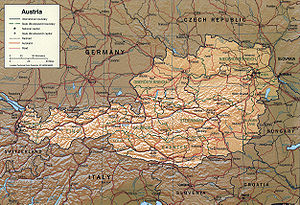
Austria may be divided into three unequal geographical areas. The largest part of Austria (62%) is occupied by the relatively young mountains of the Alps, but in the east, these give way to a part of the Pannonian plain, and north of the River Danube lies the Böhmerwald
Bohemian Forest
The Bohemian Forest, also known in Czech as Šumava , is a low mountain range in Central Europe. Geographically, the mountains extend from South Bohemia in the Czech Republic to Austria and Bavaria in Germany...
, an older, but lower, granite
Granite
Granite is a common and widely occurring type of intrusive, felsic, igneous rock. Granite usually has a medium- to coarse-grained texture. Occasionally some individual crystals are larger than the groundmass, in which case the texture is known as porphyritic. A granitic rock with a porphyritic...
mountain range.
River Danube
The DanubeDanube
The Danube is a river in the Central Europe and the Europe's second longest river after the Volga. It is classified as an international waterway....
has its source near Donaueschingen
Donaueschingen
Donaueschingen is a German town in the Black Forest in the southwest of the federal state of Baden-Württemberg in the Schwarzwald-Baar Kreis. It stands near the confluence of the two sources of the river Danube ....
in southwestern Germany and flows through Austria before emptying into the Black Sea
Black Sea
The Black Sea is bounded by Europe, Anatolia and the Caucasus and is ultimately connected to the Atlantic Ocean via the Mediterranean and the Aegean seas and various straits. The Bosphorus strait connects it to the Sea of Marmara, and the strait of the Dardanelles connects that sea to the Aegean...
. It is the only major European river that flows eastwards, and its importance as an inland waterway has been enhanced by the completion in 1992 of the Rhine-Main-Danube Canal
Rhine-Main-Danube Canal
The Rhine–Main–Danube Canal , located in Bavaria, Germany, connects the Main and the Danube rivers across the European Watershed, running from Bamberg via Nuremberg to Kelheim...
in Bavaria
Bavaria
Bavaria, formally the Free State of Bavaria is a state of Germany, located in the southeast of Germany. With an area of , it is the largest state by area, forming almost 20% of the total land area of Germany...
, which connects the Rhine and Main rivers with the Danube and makes barge
Barge
A barge is a flat-bottomed boat, built mainly for river and canal transport of heavy goods. Some barges are not self-propelled and need to be towed by tugboats or pushed by towboats...
traffic from the North Sea
North Sea
In the southwest, beyond the Straits of Dover, the North Sea becomes the English Channel connecting to the Atlantic Ocean. In the east, it connects to the Baltic Sea via the Skagerrak and Kattegat, narrow straits that separate Denmark from Norway and Sweden respectively...
to the Black Sea possible.
The major rivers north of the watershed of the Austrian Alps (the Inn
Inn River
The Inn is a river in Switzerland, Austria and Germany. It is a right tributary of the Danube and is approximately 500km long. The highest point of its drainage basin is the summit of Piz Bernina, at 4,049 metres.- Geography :...
in Tyrol, the Salzach
Salzach
The Salzach is a river in Austria and Germany. It is a right tributary of the Inn and is 225 kilometres in length.The river's name is derived from the German word Salz, meaning "salt". Until the 19th century shipping of salt down the river was an important part of the local economy...
in Salzburg, and the Enns
Enns River
The Enns is a southern tributary of the Danube River, joining northward at Enns, Austria. The Enns River spans , in a flat-J-shape. It flows from its source near the towns of Gasthofalm and Flachau, generally eastward through Radstadt, Schladming, and Liezen, then turns north near Hieflau, to flow...
in Styria and Upper Austria) are direct tributaries of the Danube and flow north into the Danube valley, whereas the rivers south of the watershed in central and eastern Austria (the Gail
Gail River
Gail is the name of a river in the Southern Limestone Alps of southern Austria, a right tributary of the Drava River.Originating in the Tyrolean municipality of Obertilliach, it flows from west to east, reaching Carinthia in Lesachtal, running through the Gail Valley parallel to the borders with...
and Drau
Drava
Drava or Drave is a river in southern Central Europe, a tributary of the Danube. It sources in Toblach/Dobbiaco, Italy, and flows east through East Tirol and Carinthia in Austria, into Slovenia , and then southeast, passing through Croatia and forming most of the border between Croatia and...
rivers in Carinthia and the Mürz
Mürz
The Mürz is a river in Austria.It begins north of the Schneealpe in Lower Austria, flows into Styria, and meets the Mur River after 98 km in Bruck an der Mur. Its headwaters end at Mürzzuschlag. Along its course are the tracks of the Southern Railway as well as the Semmering Highway....
and Mur rivers in Styria) flow south into the drainage system of the Drau, which eventually empties into the Danube in Serbia
Serbia
Serbia , officially the Republic of Serbia , is a landlocked country located at the crossroads of Central and Southeast Europe, covering the southern part of the Carpathian basin and the central part of the Balkans...
. Consequently, central and eastern Austria are geographically oriented away from the watershed of the Alps: the provinces of Upper Austria and Lower Austria toward the Danube and the provinces of Carinthia and Styria toward the Drau.
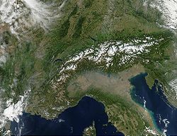
The Alps
Three major ranges of the AlpsAlps
The Alps is one of the great mountain range systems of Europe, stretching from Austria and Slovenia in the east through Italy, Switzerland, Liechtenstein and Germany to France in the west....
– the Northern Calcareous Alps, Central Alps
Central Eastern Alps
The Central Eastern Alps comprise the main chain of the Eastern Alps with its highest peaks, located between the Northern Limestone Alps and the Southern Limestone Alps, from which they differ in geological composition....
, and Southern Calcareous Alps – run west to east through Austria. The Central Alps, which consist largely of a granite base, are the largest and highest ranges in Austria. The Central Alps run from Tyrol to approximately the Styria-Lower Austria border and include areas that are permanently glaciated in the Ötztal Alps
Ötztal Alps
The Ötztal Alps are a mountain range in the central Alps of Europe, part of the Central Eastern Alps. They are arrayed at the head of the Ötztal, a side valley of the Inn River southwest of Innsbruck, Austria; the line of summits forms part of Austria's border with Italy.The western border is the...
on the Tyrolean–Italian
Italy
Italy , officially the Italian Republic languages]] under the European Charter for Regional or Minority Languages. In each of these, Italy's official name is as follows:;;;;;;;;), is a unitary parliamentary republic in South-Central Europe. To the north it borders France, Switzerland, Austria and...
border and the Hohe Tauern
Hohe Tauern
The Hohe Tauern or High Tauern are a mountain range on the main chain of the Central Eastern Alps, comprising the highest peaks east of the Brenner Pass. The crest forms the southern border of the Austrian state of Salzburg with Carinthia and East Tyrol, while a small part in the southwest belongs...
in East Tyrol
East Tyrol
East Tyrol, or East Tirol , is an exclave of the Austrian state of Tyrol, sharing no border with the main North Tyrol part of the state. It corresponds with the administrative district of Lienz....
and Carinthia. The Northern Calcareous Alps, which run from Vorarlberg through Tyrol into Salzburg along the German border and through Upper Austria and Lower Austria toward Vienna, and the Southern Calcareous Alps, on the Carinthia-Slovenia border, are predominantly limestone
Limestone
Limestone is a sedimentary rock composed largely of the minerals calcite and aragonite, which are different crystal forms of calcium carbonate . Many limestones are composed from skeletal fragments of marine organisms such as coral or foraminifera....
and dolomite
Dolomite
Dolomite is a carbonate mineral composed of calcium magnesium carbonate CaMg2. The term is also used to describe the sedimentary carbonate rock dolostone....
. At 3,797 m, Großglockner
Großglockner
The Grossglockner is, at 3,798 m above sea level, Austria's highest mountain and the highest mountain in the Alps east of the Brenner Pass...
is the highest mountain in Austria. As a general rule, the farther east the Northern and Central Alps run, the lower they become. The altitude of the mountains also drops north and south of the central ranges.
As a geographic feature, the Alps literally overshadow other landform regions. Just over 28% of Austria is moderately hilly or flat: the Northern Alpine Foreland, which includes the Danube Valley; the lowlands and hilly regions in northeastern and eastern Austria, which include the Danube Basin; and the rolling hills and lowlands of the Southeastern Alpine Foreland. The parts of Austria that are most suitable for settlement – that is, arable and climatically favorable – run north of the Alps through the provinces of Upper Austria and Lower Austria in the Danube Valley and then curve east and south of the Alps through Lower Austria, Vienna, Burgenland, and Styria. Austria's least mountainous landscape is southeast of the low Leithagebirge, which forms the southern lip of the Viennese Basin, where the steppe of the Hungarian Plain begins.
Bohemian Forest (mountain range)
The graniteGranite
Granite is a common and widely occurring type of intrusive, felsic, igneous rock. Granite usually has a medium- to coarse-grained texture. Occasionally some individual crystals are larger than the groundmass, in which case the texture is known as porphyritic. A granitic rock with a porphyritic...
massif of the Bohemian Forest
Bohemian Forest
The Bohemian Forest, also known in Czech as Šumava , is a low mountain range in Central Europe. Geographically, the mountains extend from South Bohemia in the Czech Republic to Austria and Bavaria in Germany...
(known in German
German language
German is a West Germanic language, related to and classified alongside English and Dutch. With an estimated 90 – 98 million native speakers, German is one of the world's major languages and is the most widely-spoken first language in the European Union....
as the Böhmerwald), a low mountain range with bare and windswept plateaus and a harsh climate, is located north of the Danube Valley and covers the remaining 10% of Austria's area. Notable is the Manhartsberg
Manhartsberg
Manhartsberg is a low, flat-lying mountain ridge in Lower Austria. It rises to a maximum height of 537 m. It is the southeastern flank of the granite Bohemian massif....
a granite ridge which separates Waldviertel
Waldviertel
The Waldviertel is the northwestern region of the Austrian state Lower Austria. It is bounded to the south by the Danube, to the southwest by Upper Austria, to the northwest and the north by the Czech Republic and to the east by the Manhartsberg , which is the survey point dividing Waldviertel...
from Weinviertel
Weinviertel
The Weinviertel or Viertel unter dem Manhartsberg is located in the northeast of Lower Austria....
.
Mountains

| Name | Height | Range Range -In mathematics:* Range , the set of all output values produced by a function* Interval , also called a range, a set of real numbers that includes all numbers between any two numbers in the set... |
|
|---|---|---|---|
| 1 | 3,798 m | ||
| 2 | Wildspitze Wildspitze Wildspitze is the highest mountain in the Ötztal Alps and the second highest mountain in Austria after the Großglockner. The large number of glaciers and relatively easy routes make it popular with ice climbers .... |
3,772 m | |
| 3 | Kleinglockner Kleinglockner At the Kleinglockner is the third highest mountain in Austria. However, with a prominence of only 17 metres it is arguable whether it can be counted as an independent mountain, or just as a subpeak of the Großglockner. It lies in the Glockner Group of Austria's Central Alps, the middle section of... |
3,770 m | |
| 4 | 3,739 m | ||
| 5 | 3,721 m | ||
| 6 | 3,719 m | ||
| 7 | Hofmannspitze Glocknerwand The Glocknerwand is a mountain in the Glockner Group in the Austrian Central Alps in the central region of the High Tauern. According to the literature it is 3,721 metres high, but the Austria Federal Office for Metrology and Survey gives its height as 3,722 metres... |
3,711 m | |
| 8 | Weitzenböckturm Glocknerwand The Glocknerwand is a mountain in the Glockner Group in the Austrian Central Alps in the central region of the High Tauern. According to the literature it is 3,721 metres high, but the Austria Federal Office for Metrology and Survey gives its height as 3,722 metres... |
3,702 m | |
| 9 | Draschturm Glocknerwand The Glocknerwand is a mountain in the Glockner Group in the Austrian Central Alps in the central region of the High Tauern. According to the literature it is 3,721 metres high, but the Austria Federal Office for Metrology and Survey gives its height as 3,722 metres... |
3,701 m | |
| 10 | Gerinturm Glocknerwand The Glocknerwand is a mountain in the Glockner Group in the Austrian Central Alps in the central region of the High Tauern. According to the literature it is 3,721 metres high, but the Austria Federal Office for Metrology and Survey gives its height as 3,722 metres... |
3,700 m | |
| 11 | Glocknerhorn | 3,680 m | |
| 12 | Teufelshorn | 3,677 m | |
| 13 | 3,674 m | ||
| 14 | 3,628 m | ||
| 15 | 3,628 m | ||
| 16 | Similaun Similaun Similaun is a mountain in the Schnalskamm group of the Ötztal Alps/Venoste Alps. It is on the Austrian-Italian border. At 3,606 m high, it is Austria's sixth highest summit. It was first ascended in 1834 by Josef Raffeiner and Theodor Kaserer. It is most famous for being the mountain on whose... |
3,606 m | |
| 17 | Großes Wiesbachhorn Großes Wiesbachhorn The Großes Wiesbachhorn is a mountain in the federal state of Salzburg, Austria and, at , is the third-highest peak of the Hohe Tauern range.... |
3,564 m | |
| 18 | Rainerhorn | 3,560 m | |
| 19 | 3,556 m | ||
| 20 | Marzellspitze Marzellspitze The Östliche Marzellspitze is a mountain in the Ötztal Alps on the border between Tyrol, Austria, and South Tyrol, Italy.- References :* Walter Klier, Alpenvereinsführer Ötztaler Alpen, München 2002, ISBN 3-7633-1123-8... |
3,555 m | |
| 21 | Ramolkogel | 3,550 m | |
| 22 | Schalfkogel Schalfkogel - Avalanche :The 2009 Schalfkogel avalanche occurred in Sölden, Austria, on 3 May 2009. Six people were killed: five Czechs and one Slovak, when the disaster struck in the 3,500-metre Schalfkogel mountain range. The corpses were discovered to have been frozen upon recovery. It was the deadliest... |
3,540 m | |
| 23 | Watzespitze Watzespitze The Watzespitze or Waze is the highest mountain in the Kaunergrat group of the Ötztal Alps. It is located in Austria.... |
3,533 m | |
| 24 | Hochvernagtspitze | 3,530 m | |
| 25 | Langtaufererspitze | 3,529 m | |
| 26 | 3,526 m | ||
| 27 | Mutmalspitze | 3,522 m | |
| 28 | Fineilspitze Fineilspitze The Fineilspitze is a peak in the Schnalskamm group of the Ötztal Alps on the border between Tyrol, Austria, and South Tyrol, Italy.- References :* *... |
3,516 m | |
| 29 | 3,515 m | ||
| 30 | Hochfeiler Hochfeiler The Hochfeiler is a mountain in the Zillertal Alps on the border between Tyrol, Austria, and South Tyrol, Italy.- References :* Heinrich Klier, Walter Klier: Alpenvereinsführer Zillertaler Alpen, Rother Verlag München , ISBN 3-7633-1269-2... |
3,510 m | Zillertal Alps Zillertal Alps The Zillertal Alps are a mountain range of the Central Eastern Alps on the border of Austria and Italy. The range is named after the Zillertal on its north.... |
| 31 | Teufelskamp | 3,509 m | |
| 32 | Romariswandkopf | 3.,08 m | |
| 33 | Zuckerhütl Zuckerhütl The Zuckerhütl is a mountain in Tyrol, Austria. At 3,505 metres , it is the highest peak of the Stubai Alps and at the southern end of the Stubaital.... |
3,505 m | Stubai Alps Stubai Alps The Stubai Alps is a mountain range in the Central Eastern Alps of Europe. It is named after the Stubaital valley to its east. It is located southwest of Innsbruck, Austria, and several summits of the range form part of Austria's border with Italy... |
| 34 | 3,504 m | ||
| 35 | Fluchtkogel | 3,500 m |
(All heights are related to the 1875 Trieste tide gauge used in Austria - metres above the Adriatic
Metres above the Adriatic
Metres above the Adriatic is an elevation reference system used in Austria and some other European countries based on the average water level of the Adriatic Sea at the Molo Sartorio in Triest harbour...
)
Human geography


Arable land
In geography and agriculture, arable land is land that can be used for growing crops. It includes all land under temporary crops , temporary meadows for mowing or pasture, land under market and kitchen gardens and land temporarily fallow...
and suitable for conventional agriculture
Agriculture
Agriculture is the cultivation of animals, plants, fungi and other life forms for food, fiber, and other products used to sustain life. Agriculture was the key implement in the rise of sedentary human civilization, whereby farming of domesticated species created food surpluses that nurtured the...
. The percentage of arable land in Austria increases in the East as the country becomes less alpine. More than one-fifth of Austria is pasture and meadow located at varying altitudes. Almost half of this grassland
Grassland
Grasslands are areas where the vegetation is dominated by grasses and other herbaceous plants . However, sedge and rush families can also be found. Grasslands occur naturally on all continents except Antarctica...
consists of high Alpine pastures.
Historically, high Alpine pastures have been used during the summer for grazing dairy cattle, thus making space available at lower altitudes for cultivating and harvesting fodder for winter. Many of the high pastures are at altitudes of more than 1,000 m.
Although agriculture in mountainous areas was at one time economically viable, in recent decades it has survived only with the help of extensive subsidies. A concern of farmers in these mountainous regions is that membership of the European Union
European Union
The European Union is an economic and political union of 27 independent member states which are located primarily in Europe. The EU traces its origins from the European Coal and Steel Community and the European Economic Community , formed by six countries in 1958...
might entail a curtailment of these subsidies and the end of Alpine agriculture. If this occurs, many areas will be reclaimed by nature after centuries of cultivation.
Although the Alps are beautiful, they make many areas of Austria uninhabitable. Austria's so-called areas of permanent settlement – regions that are cultivated, continuously inhabited, and used for transportation, but do not include forests, Alpine pastures, or barren land – cover only 40% or 35,000 km² of the country. The great majority of the area of permanent settlement is in the Danube valley and the lowlands or hilly regions north, east, and south of the Alps, where approximately two-thirds of the population lives.
In the country's predominantly Alpine provinces, most of the population live in river valleys: Bregenz on the shores of Lake Constance in Vorarlberg; Innsbruck on the Inn River in Tyrol; Salzburg on the Salzach River in Salzburg; and Klagenfurt on the Wörthersee
Wörthersee
The Wörthersee is an alpine lake in the southern Austrian state of Carinthia.-General facts:The lake is elongated, about 20 km long and 1–2 km wide. It stretches from the Carinthian capital Klagenfurt in the east to Velden in the west...
lake in Carinthia. The higher the Alps are, the less inhabitable they become in terms of soil, microclimate, and vegetation. Conversely, the lower and broader the Alpine valleys are, the more densely populated they become.
Tyrol illustrates most clearly the relationship between Alpine geography and habitation. As the most mountainous province (less than 3% of the land is arable), it is the most sparsely inhabited, with an area of permanent settlement of only 15%.
Because of the Alps, the country as a whole is one of the least densely populated states of Western and Central Europe. With ninety-three inhabitants per square kilometer, Austria has a population density similar to that of the former Yugoslavia
Yugoslavia
Yugoslavia refers to three political entities that existed successively on the western part of the Balkans during most of the 20th century....
.
Austria's national borders and geography have corresponded very little. Since the fall of the Roman Empire, the Alps and the Danube have not served to mark political boundaries. Even within Austria, provincial borders were only occasionally set by the ranges and ridges of the Alps.
Although the Alps did not mark political boundaries, they often separated groups of people from one another. Because in the past the Alps were impassable, inhabitants isolated in valleys or networks of valleys developed distinct regional subcultures. Consequently, the inhabitants of one valley frequently maintained dialects, native or traditional dress, architectural styles, and folklore that substantially differed from those of the next valley. Differences were great enough that the origins of outsiders could easily be identified. However, mass media, mobility, prosperity, and tourism have eroded the distinctness of Alpine regional subcultures to a great extent by reducing the isolation that gave them their particular character.
Despite the Alps, Austria has historically been a land of transit. The Danube valley, for centuries Central Europe's
Central Europe
Central Europe or alternatively Middle Europe is a region of the European continent lying between the variously defined areas of Eastern and Western Europe...
aquatic link to the Balkan Peninsula and the "Orient
Orient
The Orient means "the East." It is a traditional designation for anything that belongs to the Eastern world or the Far East, in relation to Europe. In English it is a metonym that means various parts of Asia.- Derivation :...
" in the broadest sense of the word, has always been an avenue of east–west transit. However, Europe's division into two opposing economic and military blocs after World War II
World War II
World War II, or the Second World War , was a global conflict lasting from 1939 to 1945, involving most of the world's nations—including all of the great powers—eventually forming two opposing military alliances: the Allies and the Axis...
diminished Austria's importance as a place of transit. Since the opening of Eastern Europe
Eastern Europe
Eastern Europe is the eastern part of Europe. The term has widely disparate geopolitical, geographical, cultural and socioeconomic readings, which makes it highly context-dependent and even volatile, and there are "almost as many definitions of Eastern Europe as there are scholars of the region"...
in 1989, the country has begun to re-assume its historical role. By the early 1990s, it had already experienced a substantial increase in the number of people and vehicles crossing its eastern frontiers.
Within the Alps, four passes and the roads that run through them are of particular importance for north–south transit. The Semmering Pass on the provincial border of Lower Austria and Styria connects the Viennese Basin with the Mürz and Mur valleys, thus providing northeast-southwest access to Styria and Slovenia, and, via Carinthia, to Italy.
The Pyrhn Pass between the provinces of Upper Austria and Styria and the Tauern Pass between the Hohe Tauern
Hohe Tauern
The Hohe Tauern or High Tauern are a mountain range on the main chain of the Central Eastern Alps, comprising the highest peaks east of the Brenner Pass. The crest forms the southern border of the Austrian state of Salzburg with Carinthia and East Tyrol, while a small part in the southwest belongs...
range and the Niedere Tauern
Niedere Tauern
The Niedere Tauern or Low Tauern are a mountain range in central Austria, part of the Central Eastern Alps. They lie on the main chain of the Alps in in the states of Salzburger Land and Styria...
range of the Central Alps in Salzburg, provide access to the Mur Valley in Styria and the Drau Valley in Carinthia, respectively. The highways that run through these passes are important northwest-southeast lines of communication through the Alps. The Pyrhn highway has been nicknamed the Fremdarbeiterweg ("foreign workers' route") because millions of Gastarbeiter
Gastarbeiter
Gastarbeiter is German for "guest worker." It refers to migrant workers who had moved to West Germany mainly in the 1960s and 70s, seeking work as part of a formal guest worker programme...
("guest workers") in Germany use it to return to their homes in the Balkans
Balkans
The Balkans is a geopolitical and cultural region of southeastern Europe...
and Turkey
Turkey
Turkey , known officially as the Republic of Turkey , is a Eurasian country located in Western Asia and in East Thrace in Southeastern Europe...
for vacation. Many Germans and northern Europeans also use it in the summer months to reach the Adriatic coast
Adriatic Sea
The Adriatic Sea is a body of water separating the Italian Peninsula from the Balkan peninsula, and the system of the Apennine Mountains from that of the Dinaric Alps and adjacent ranges...
. After the outbreak of hostilities in Yugoslavia in the summer of 1991, however, a substantial amount of this traffic was re-routed through the Danube Valley and Hungary
Hungary
Hungary , officially the Republic of Hungary , is a landlocked country in Central Europe. It is situated in the Carpathian Basin and is bordered by Slovakia to the north, Ukraine and Romania to the east, Serbia and Croatia to the south, Slovenia to the southwest and Austria to the west. The...
.
The most important pass in the Austrian Alps is the Brenner Pass
Brenner Pass
- Roadways :The motorway E45 leading from Innsbruck via Bolzano to Verona and Modena uses this pass, and is one of the most important north-south connections in Europe...
, located on the Austrian-Italian border in Tyrol. At 1,370 m, it is one of the lowest Alpine passes. The route up the Inn valley and over the Brenner Pass has been historically an important and convenient route of north–south transit between Germany and Italy, and provides the most direct route between Europe's two most highly industrialized regions: Germany and northern Italy.
Natural resources:
iron ore, oil
Petroleum
Petroleum or crude oil is a naturally occurring, flammable liquid consisting of a complex mixture of hydrocarbons of various molecular weights and other liquid organic compounds, that are found in geologic formations beneath the Earth's surface. Petroleum is recovered mostly through oil drilling...
, lignite
Lignite
Lignite, often referred to as brown coal, or Rosebud coal by Northern Pacific Railroad,is a soft brown fuel with characteristics that put it somewhere between coal and peat...
, timber
Timber
Timber may refer to:* Timber, a term common in the United Kingdom and Australia for wood materials * Timber, Oregon, an unincorporated community in the U.S...
, iron ore, copper
Copper
Copper is a chemical element with the symbol Cu and atomic number 29. It is a ductile metal with very high thermal and electrical conductivity. Pure copper is soft and malleable; an exposed surface has a reddish-orange tarnish...
, zinc
Zinc
Zinc , or spelter , is a metallic chemical element; it has the symbol Zn and atomic number 30. It is the first element in group 12 of the periodic table. Zinc is, in some respects, chemically similar to magnesium, because its ion is of similar size and its only common oxidation state is +2...
, antimony
Antimony
Antimony is a toxic chemical element with the symbol Sb and an atomic number of 51. A lustrous grey metalloid, it is found in nature mainly as the sulfide mineral stibnite...
, magnesite
Magnesite
Magnesite is magnesium carbonate, MgCO3. Iron substitutes for magnesium with a complete solution series with siderite, FeCO3. Calcium, manganese, cobalt, and nickel may also occur in small amounts...
, tungsten
Tungsten
Tungsten , also known as wolfram , is a chemical element with the chemical symbol W and atomic number 74.A hard, rare metal under standard conditions when uncombined, tungsten is found naturally on Earth only in chemical compounds. It was identified as a new element in 1781, and first isolated as...
, graphite
Graphite
The mineral graphite is one of the allotropes of carbon. It was named by Abraham Gottlob Werner in 1789 from the Ancient Greek γράφω , "to draw/write", for its use in pencils, where it is commonly called lead . Unlike diamond , graphite is an electrical conductor, a semimetal...
, salt
Salt
In chemistry, salts are ionic compounds that result from the neutralization reaction of an acid and a base. They are composed of cations and anions so that the product is electrically neutral...
, hydropower
Hydropower
Hydropower, hydraulic power, hydrokinetic power or water power is power that is derived from the force or energy of falling water, which may be harnessed for useful purposes. Since ancient times, hydropower has been used for irrigation and the operation of various mechanical devices, such as...
Land use:
arable land:
16.59%
permanent crops:
0.85%
other:
82.56% (2005)
Irrigated land:
40 km² (2003)
Climate

Water divide
A drainage divide, water divide, divide or watershed is the line separating neighbouring drainage basins...
for Europe's three major kinds of weather systems that influence Austrian weather. The Atlantic maritime climate from the northwest is characterized by low pressure fronts, mild air from the Gulf Stream
Gulf Stream
The Gulf Stream, together with its northern extension towards Europe, the North Atlantic Drift, is a powerful, warm, and swift Atlantic ocean current that originates at the tip of Florida, and follows the eastern coastlines of the United States and Newfoundland before crossing the Atlantic Ocean...
, and precipitation. It has the greatest influence on the northern slopes of the Alps, the Northern Alpine Foreland, and the Danube valley. The continental climate is characterized by low pressure fronts with precipitation in summer and high pressure systems with cold and dry air in winter. It affects mainly eastern Austria. Mediterranean high-pressure systems from the south are characterized by few clouds and warm air, and they influence the weather of the southern slopes of the Alps and that of the Southeastern Alpine Foreland, making them the most temperate part of Austria.
One peculiarity of the Mediterranean weather systems is the föhn wind, a warm air mass that originates in the African Sahara
Sahara
The Sahara is the world's second largest desert, after Antarctica. At over , it covers most of Northern Africa, making it almost as large as Europe or the United States. The Sahara stretches from the Red Sea, including parts of the Mediterranean coasts, to the outskirts of the Atlantic Ocean...
and moves north rapidly, periodically raising temperatures up to 10 C-change in a short period of time. Many people respond to this rapid weather change with headache
Headache
A headache or cephalalgia is pain anywhere in the region of the head or neck. It can be a symptom of a number of different conditions of the head and neck. The brain tissue itself is not sensitive to pain because it lacks pain receptors. Rather, the pain is caused by disturbance of the...
s, irritability
Irritability
Irritability is an excessive response to stimuli. The term is used for both the physiological reaction to stimuli and for the pathological, abnormal or excessive sensitivity to stimuli; It is usually used to refer to anger or frustration....
, and circulatory problems. During the winter, the rapid warming that accompanies a föhn can thaw the snow cover in the Alps to such an extent that avalanche
Avalanche
An avalanche is a sudden rapid flow of snow down a slope, occurring when either natural triggers or human activity causes a critical escalating transition from the slow equilibrium evolution of the snow pack. Typically occurring in mountainous terrain, an avalanche can mix air and water with the...
s occur.
Given the importance of Alpine skiing
Skiing
Skiing is a recreational activity using skis as equipment for traveling over snow. Skis are used in conjunction with boots that connect to the ski with use of a binding....
for the Austrian tourist industry, December is the month during which the weather is watched with the greatest anticipation. As a rule, Atlantic maritime weather systems bring snow, and continental weather systems help keep it. However, a predominance of cold, dry continental systems or warm Mediterranean ones inevitably postpone the beginning of the ski season. In the summer, Mediterranean high-pressure systems bring warm, sunny weather.
Ecological concerns
Austrians faced a number of ecological problems in the 1990s. One of the most pressing is the pollution caused by the staggering increase of traffic through the country. Traffic on the superhighway going through the Brenner Pass has, for example, increased from 600,000 vehicles per year in the early 1970s to over 10 million per year in the early 1990s. One quarter of the traffic crossing Austria consists of semitrailers used for heavy transport. The opening of Eastern Europe has only exacerbated the problem of transit traffic.The Alpine valleys through which much of this traffic passes are unusually vulnerable to ecological damage. Narrow valleys are not conducive to dissipation of noise or pollutants caused by motor vehicles. Inversions – cold layers of air that trap warm layers of air or warm layers of air that trap cold layers in the valleys and lowlands – also seasonally contribute to the magnitude of the pollution problem.
Austria has negotiated with the EU to set limits on the amount of commercial transit traffic, especially through Tyrol. Work is also under way to develop a "piggy-back" system of loading semitrailers on to flatbed railroad cars in southern Germany and northern Italy, transporting them through Tyrol by rail. Environmentalists have pushed for measures that are more far-reaching. They advocate, for example, digging a tunnel from Garmisch-Partenkirchen
Garmisch-Partenkirchen
Garmisch-Partenkirchen is a mountain resort town in Bavaria, southern Germany. It is the administrative centre of the district of Garmisch-Partenkirchen, in the Oberbayern region, and the district is on the border with Austria...
in southern Germany to Bolzano in northern Italy.
Pollution is also brought by the weather systems that determine the country's climate. Atlantic maritime weather systems carry pollution into Austria from northwestern Europe. Austria's proximity to industrialized regions of former Communist states, with negligible or no pollution control policies or equipment, combined with the influence of continental weather systems also have proved to be extremely harmful. Mediterranean weather systems transmit industrial pollutants from northern Italy.
As a result of domestic and foreign pollution, 37% of Austria's forests had been damaged by acid rain
Acid rain
Acid rain is a rain or any other form of precipitation that is unusually acidic, meaning that it possesses elevated levels of hydrogen ions . It can have harmful effects on plants, aquatic animals, and infrastructure. Acid rain is caused by emissions of carbon dioxide, sulfur dioxide and nitrogen...
and/or pollutant emissions by 1991. The damage to forests has had dire consequences, including the decimation of forests that for centuries had protected many Alpine communities from avalanches, erosion
Erosion
Erosion is when materials are removed from the surface and changed into something else. It only works by hydraulic actions and transport of solids in the natural environment, and leads to the deposition of these materials elsewhere...
, mudslides, or flood
Flood
A flood is an overflow of an expanse of water that submerges land. The EU Floods directive defines a flood as a temporary covering by water of land not normally covered by water...
ing caused by runoff.
The seriousness of the ecological problems confronting the country gave rise in the 1970s to an environmentalist movement. Political parties were formed, and representatives were elected to parliament. A referendum
Referendum
A referendum is a direct vote in which an entire electorate is asked to either accept or reject a particular proposal. This may result in the adoption of a new constitution, a constitutional amendment, a law, the recall of an elected official or simply a specific government policy. It is a form of...
in 1978 closed down a newly completed nuclear power station and turned the country away from the exploitation of nuclear energy. Public opposition in 1984 stopped the planned construction of a hydroelectric power station in a wetlands region.
The country's long-standing commercial use of the Alps for recreational purposes has also come under examination. Extensive tourism places an inordinate amount of pressure on sensitive Alpine ecosystems. Ski runs damage forests, as do summer sports such as off-trail mountain hiking or mountain biking. Many Alpine villages have also grown greatly because of the tourist industry. In extreme cases, they have up to twenty hotel beds for each inhabitant, a ratio that places a disproportionate seasonal burden on communal infrastructures and the environment. For these reasons, efforts have been made to introduce "green" or "soft" forms of tourism that are more compatible with the Alpine environment.
Part of the solution to Austria's ecological problems is being sought in stricter environmental legislation at the domestic level. Ultimately, however, pan-European and global cooperation in the realm of pollution and emission control will be necessary to protect the country's environment.
Environment - current issues:
some forest degradation caused by air and soil pollution
Pollution
Pollution is the introduction of contaminants into a natural environment that causes instability, disorder, harm or discomfort to the ecosystem i.e. physical systems or living organisms. Pollution can take the form of chemical substances or energy, such as noise, heat or light...
; soil pollution results from the use of agricultural chemicals; air pollution results from emissions by coal- and oil-fired power stations and industrial plants and from trucks transiting Austria between northern and southern Europe
Environment - international agreements:
party to:
Air Pollution, Air Pollution-Nitrogen Oxides, Air Pollution-Sulphur 85, Air Pollution-Sulphur 94, Air Pollution-Volatile Organic Compounds, Antarctic Treaty, Biodiversity, Climate Change, Desertification
Desertification
Desertification is the degradation of land in drylands. Caused by a variety of factors, such as climate change and human activities, desertification is one of the most significant global environmental problems.-Definitions:...
, Endangered Species, Environmental Modification, Hazardous Wastes, Law of the Sea, Nuclear Test Ban, Ozone Layer Protection, Ship Pollution, Tropical Timber 83, Tropical Timber 94, Wetlands, Whaling
signed, but not ratified:
Air Pollution-Persistent Organic Pollutants, Antarctic-Environmental Protocol, Climate Change-Kyoto Protocol
Kyoto Protocol
The Kyoto Protocol is a protocol to the United Nations Framework Convention on Climate Change , aimed at fighting global warming...
Area and boundaries
Area
- Total: 83,871 km²
- country comparison to the world: 120
- Land: 82,738 km²
- Water: 1,120 km²
Area comparison
- AustraliaAustraliaAustralia , officially the Commonwealth of Australia, is a country in the Southern Hemisphere comprising the mainland of the Australian continent, the island of Tasmania, and numerous smaller islands in the Indian and Pacific Oceans. It is the world's sixth-largest country by total area...
comparative: slightly larger than TasmaniaTasmaniaTasmania is an Australian island and state. It is south of the continent, separated by Bass Strait. The state includes the island of Tasmania—the 26th largest island in the world—and the surrounding islands. The state has a population of 507,626 , of whom almost half reside in the greater Hobart... - ChinaChinaChinese civilization may refer to:* China for more general discussion of the country.* Chinese culture* Greater China, the transnational community of ethnic Chinese.* History of China* Sinosphere, the area historically affected by Chinese culture...
comparative: about half of JiangxiJiangxi' is a southern province in the People's Republic of China. Spanning from the banks of the Yangtze River in the north into hillier areas in the south, it shares a border with Anhui to the north, Zhejiang to the northeast, Fujian to the east, Guangdong to the south, Hunan to the west, and Hubei to... - CanadaCanadaCanada is a North American country consisting of ten provinces and three territories. Located in the northern part of the continent, it extends from the Atlantic Ocean in the east to the Pacific Ocean in the west, and northward into the Arctic Ocean...
comparative: larger than New BrunswickNew BrunswickNew Brunswick is one of Canada's three Maritime provinces and is the only province in the federation that is constitutionally bilingual . The provincial capital is Fredericton and Saint John is the most populous city. Greater Moncton is the largest Census Metropolitan Area... - United KingdomUnited KingdomThe United Kingdom of Great Britain and Northern IrelandIn the United Kingdom and Dependencies, other languages have been officially recognised as legitimate autochthonous languages under the European Charter for Regional or Minority Languages...
comparative: slightly larger than ScotlandScotlandScotland is a country that is part of the United Kingdom. Occupying the northern third of the island of Great Britain, it shares a border with England to the south and is bounded by the North Sea to the east, the Atlantic Ocean to the north and west, and the North Channel and Irish Sea to the... - United StatesUnited StatesThe United States of America is a federal constitutional republic comprising fifty states and a federal district...
comparative: slightly smaller than MaineMaineMaine is a state in the New England region of the northeastern United States, bordered by the Atlantic Ocean to the east and south, New Hampshire to the west, and the Canadian provinces of Quebec to the northwest and New Brunswick to the northeast. Maine is both the northernmost and easternmost...
Extreme points

Elevation
- Highest point: GroßglocknerGroßglocknerThe Grossglockner is, at 3,798 m above sea level, Austria's highest mountain and the highest mountain in the Alps east of the Brenner Pass...
, at 3798 m, 47°4′30"N 12°41′40"E - Lowest point: Hedwighof (Municipality ApetlonApetlonApetlon is a market town in the district of Neusiedl am See in Burgenland in Austria. It is located in a region to the east of the Lake Neusiedl which is named the Seewinkel .-Geography:...
, at 114 m, 47°52′N 16°45′E
Latitude and longitude
- Westernmost point: River Rhine near Bangs, VorarlbergVorarlbergVorarlberg is the westernmost federal-state of Austria. Although it is the second smallest in terms of area and population , it borders three countries: Germany , Switzerland and Liechtenstein...
, 47°16′16"N 9°31′51"E, but note that the international borders between Austria, GermanyGermanyGermany , officially the Federal Republic of Germany , is a federal parliamentary republic in Europe. The country consists of 16 states while the capital and largest city is Berlin. Germany covers an area of 357,021 km2 and has a largely temperate seasonal climate...
and SwitzerlandSwitzerlandSwitzerland name of one of the Swiss cantons. ; ; ; or ), in its full name the Swiss Confederation , is a federal republic consisting of 26 cantons, with Bern as the seat of the federal authorities. The country is situated in Western Europe,Or Central Europe depending on the definition....
are not agreed for Lake ConstanceLake ConstanceLake Constance is a lake on the Rhine at the northern foot of the Alps, and consists of three bodies of water: the Obersee , the Untersee , and a connecting stretch of the Rhine, called the Seerhein.The lake is situated in Germany, Switzerland and Austria near the Alps...
. - Westernmost settlement: Bangs, Vorarlberg, 47°15′56"N 9°32′42"E
- Easternmost point: the corner of a field near Deutsch JahrndorfDeutsch JahrndorfDeutsch Jahrndorf is a municipality in the district of Neusiedl am See, in the Austrian state of Burgenland. It is within a few kilometres of the borders with both Hungary and Slovakia...
, BurgenlandBurgenlandBurgenland is the easternmost and least populous state or Land of Austria. It consists of two Statutarstädte and seven districts with in total 171 municipalities. It is 166 km long from north to south but much narrower from west to east...
, 48°0′24"N 17°9′38"E - Easternmost settlement: Deutsch JahrndorfDeutsch JahrndorfDeutsch Jahrndorf is a municipality in the district of Neusiedl am See, in the Austrian state of Burgenland. It is within a few kilometres of the borders with both Hungary and Slovakia...
, Burgenland, 48°0′37"N 17°6′33"E - Northernmost point: the Neumühlbach stream, near Rottal, Lower AustriaLower AustriaLower Austria is the northeasternmost state of the nine states in Austria. The capital of Lower Austria since 1986 is Sankt Pölten, the most recently designated capital town in Austria. The capital of Lower Austria had formerly been Vienna, even though Vienna is not officially part of Lower Austria...
, 49°1′14"N 15°1′16"E - Northernmost settlement: HaugschlagHaugschlagHaugschlag is a municipality in the district of Gmünd in the Austrian state of Lower Austria. It is Austria's northernmost municipality, located in the Waldviertel region close to the Czech border. It comprises the Katastralgemeinden of Griesbach, Haugschlag, Rottal and Türnau....
, Lower Austria, 48°59′51"N 15°3′32"E - Southernmost point: in the Steiner Alpen, CarinthiaCarinthia (state)Carinthia is the southernmost Austrian state or Land. Situated within the Eastern Alps it is chiefly noted for its mountains and lakes.The main language is German. Its regional dialects belong to the Southern Austro-Bavarian group...
, between the Seeländer Sattel and the Sanntaler Sattel, at an altitude of more than 2000 m, 46°22′21"N 14°33′55"E - Southernmost settlement: Bad Vellach, Carinthia, 46°25′37"N 14°32′58"E
Center
- Geographical centreCentroidIn geometry, the centroid, geometric center, or barycenter of a plane figure or two-dimensional shape X is the intersection of all straight lines that divide X into two parts of equal moment about the line. Informally, it is the "average" of all points of X...
: 47°41′47.5"N 13°20′44.5"E - Furthest point from any international border: near Gstatterboden, in the Gesäuse National ParkGesäuse National ParkThe Gesäuse National Park is a national park in the Austrian state of Styria. Located in the mountainous Upper Styrian region, it covers large parts of the Gesäuse range within the Ennstal Alps and the steep water gap of the Enns river between Admont and Hieflau...
, StyriaStyria (state)Styria is a state or Bundesland, located in the southeast of Austria. In area it is the second largest of the nine Austrian federated states, covering 16,401 km². It borders Slovenia as well as the other Austrian states of Upper Austria, Lower Austria, Salzburg, Burgenland, and Carinthia. ...
, over 100 km from any border, 47°35′30"N 14°38′0"E