
Geography of Australia
Encyclopedia
| Geography of Australia | |
 |
|
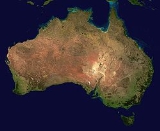
| Continent | Australia Australia (continent) Australia is the world's smallest continent, comprising the mainland of Australia and proximate islands including Tasmania, New Guinea, the Aru Islands and Raja Ampat Islands... |
| Region | Oceania Oceania Oceania is a region centered on the islands of the tropical Pacific Ocean. Conceptions of what constitutes Oceania range from the coral atolls and volcanic islands of the South Pacific to the entire insular region between Asia and the Americas, including Australasia and the Malay Archipelago... |
| Coordinates | 27°S 144°E |
| Area | Ranked 6th 7,686,850 km2 2,967,910 sq mi 99% land 1% water |
| Coastline | 25,765 km (16,000 mi) |
| Borders | 0 km |
| Highest point | Mount Kosckiusko 2,234 m (7,310 ft) |
| Lowest point | Lake Eyre Lake Eyre Lake Eyre is the lowest point in Australia, at approximately below sea level, and, on the rare occasions that it fills, it is the largest lake in Australia and 18th largest in the world... |
| Longest river | Murray River Murray River The Murray River is Australia's longest river. At in length, the Murray rises in the Australian Alps, draining the western side of Australia's highest mountains and, for most of its length, meanders across Australia's inland plains, forming the border between New South Wales and Victoria as it... 2,375 km (1,476 mi) |
| Largest lake | Lake Eyre Lake Eyre Lake Eyre is the lowest point in Australia, at approximately below sea level, and, on the rare occasions that it fills, it is the largest lake in Australia and 18th largest in the world... 9,500 km² (3,668 sq mi) |
The geography
Geography
Geography is the science that studies the lands, features, inhabitants, and phenomena of Earth. A literal translation would be "to describe or write about the Earth". The first person to use the word "geography" was Eratosthenes...
of Australia
Australia
Australia , officially the Commonwealth of Australia, is a country in the Southern Hemisphere comprising the mainland of the Australian continent, the island of Tasmania, and numerous smaller islands in the Indian and Pacific Oceans. It is the world's sixth-largest country by total area...
encompasses a wide variety of biogeographic
Biogeography
Biogeography is the study of the distribution of species , organisms, and ecosystems in space and through geological time. Organisms and biological communities vary in a highly regular fashion along geographic gradients of latitude, elevation, isolation and habitat area...
regions being the world's smallest continent
Australia (continent)
Australia is the world's smallest continent, comprising the mainland of Australia and proximate islands including Tasmania, New Guinea, the Aru Islands and Raja Ampat Islands...
but the sixth-largest country in the world. The population of Australia
Australia
Australia , officially the Commonwealth of Australia, is a country in the Southern Hemisphere comprising the mainland of the Australian continent, the island of Tasmania, and numerous smaller islands in the Indian and Pacific Oceans. It is the world's sixth-largest country by total area...
is concentrated along the eastern and southeastern coasts. The geography of the country is extremely diverse, ranging from the snow
Snow
Snow is a form of precipitation within the Earth's atmosphere in the form of crystalline water ice, consisting of a multitude of snowflakes that fall from clouds. Since snow is composed of small ice particles, it is a granular material. It has an open and therefore soft structure, unless packed by...
capped mountains of the Australian Alps
Australian Alps
The Australian Alps are the highest mountain ranges of mainland Australia. They are located in southeastern Australia and straddle the Australian Capital Territory, south-eastern New South Wales and eastern Victoria...
and Tasmania
Tasmania
Tasmania is an Australian island and state. It is south of the continent, separated by Bass Strait. The state includes the island of Tasmania—the 26th largest island in the world—and the surrounding islands. The state has a population of 507,626 , of whom almost half reside in the greater Hobart...
to large deserts
Déserts
Déserts is a piece by Edgard Varèse for brass , percussion , piano, and tape. Percussion instruments are exploited for their resonant potential, rather than used solely as accompaniment...
, tropical and temperate forests.
Neighbouring countries include Indonesia
Indonesia
Indonesia , officially the Republic of Indonesia , is a country in Southeast Asia and Oceania. Indonesia is an archipelago comprising approximately 13,000 islands. It has 33 provinces with over 238 million people, and is the world's fourth most populous country. Indonesia is a republic, with an...
, East Timor
East Timor
The Democratic Republic of Timor-Leste, commonly known as East Timor , is a state in Southeast Asia. It comprises the eastern half of the island of Timor, the nearby islands of Atauro and Jaco, and Oecusse, an exclave on the northwestern side of the island, within Indonesian West Timor...
and Papua New Guinea
Papua New Guinea
Papua New Guinea , officially the Independent State of Papua New Guinea, is a country in Oceania, occupying the eastern half of the island of New Guinea and numerous offshore islands...
to the north, the Solomon Islands
Solomon Islands
Solomon Islands is a sovereign state in Oceania, east of Papua New Guinea, consisting of nearly one thousand islands. It covers a land mass of . The capital, Honiara, is located on the island of Guadalcanal...
, Vanuatu
Vanuatu
Vanuatu , officially the Republic of Vanuatu , is an island nation located in the South Pacific Ocean. The archipelago, which is of volcanic origin, is some east of northern Australia, northeast of New Caledonia, west of Fiji, and southeast of the Solomon Islands, near New Guinea.Vanuatu was...
and the French dependency of New Caledonia
New Caledonia
New Caledonia is a special collectivity of France located in the southwest Pacific Ocean, east of Australia and about from Metropolitan France. The archipelago, part of the Melanesia subregion, includes the main island of Grande Terre, the Loyalty Islands, the Belep archipelago, the Isle of...
to the east, and New Zealand
New Zealand
New Zealand is an island country in the south-western Pacific Ocean comprising two main landmasses and numerous smaller islands. The country is situated some east of Australia across the Tasman Sea, and roughly south of the Pacific island nations of New Caledonia, Fiji, and Tonga...
to the southeast.
Physical geography

Country
A country is a region legally identified as a distinct entity in political geography. A country may be an independent sovereign state or one that is occupied by another state, as a non-sovereign or formerly sovereign political division, or a geographic region associated with a previously...
, an island
Island
An island or isle is any piece of sub-continental land that is surrounded by water. Very small islands such as emergent land features on atolls can be called islets, cays or keys. An island in a river or lake may be called an eyot , or holm...
, and a continent
Continent
A continent is one of several very large landmasses on Earth. They are generally identified by convention rather than any strict criteria, with seven regions commonly regarded as continents—they are : Asia, Africa, North America, South America, Antarctica, Europe, and Australia.Plate tectonics is...
. It is located in Oceania
Oceania
Oceania is a region centered on the islands of the tropical Pacific Ocean. Conceptions of what constitutes Oceania range from the coral atolls and volcanic islands of the South Pacific to the entire insular region between Asia and the Americas, including Australasia and the Malay Archipelago...
between the Indian Ocean
Indian Ocean
The Indian Ocean is the third largest of the world's oceanic divisions, covering approximately 20% of the water on the Earth's surface. It is bounded on the north by the Indian Subcontinent and Arabian Peninsula ; on the west by eastern Africa; on the east by Indochina, the Sunda Islands, and...
and the South Pacific Ocean
Pacific Ocean
The Pacific Ocean is the largest of the Earth's oceanic divisions. It extends from the Arctic in the north to the Southern Ocean in the south, bounded by Asia and Australia in the west, and the Americas in the east.At 165.2 million square kilometres in area, this largest division of the World...
at 27°S 144°E. It is the sixth largest country in the world with a total area of 7,686,850 square kilometers (2,967,909 sq. mi) (including Lord Howe Island
Lord Howe Island
Lord Howe Island is an irregularly crescent-shaped volcanic remnant in the Tasman Sea between Australia and New Zealand, directly east of mainland Port Macquarie, and about from Norfolk Island. The island is about 11 km long and between 2.8 km and 0.6 km wide with an area of...
and Macquarie Island
Macquarie Island
Macquarie Island lies in the southwest corner of the Pacific Ocean, about half-way between New Zealand and Antarctica, at 54°30S, 158°57E. Politically, it has formed part of the Australian state of Tasmania since 1900 and became a Tasmanian State Reserve in 1978. In 1997 it became a world heritage...
), making it slightly smaller than the contiguous 48 states of the United States
United States
The United States of America is a federal constitutional republic comprising fifty states and a federal district...
and 31.5 times larger than the United Kingdom
United Kingdom
The United Kingdom of Great Britain and Northern IrelandIn the United Kingdom and Dependencies, other languages have been officially recognised as legitimate autochthonous languages under the European Charter for Regional or Minority Languages...
.
The Australian mainland has a total coastline length of 35876 km (22,292.4 mi) with an additional 23859 km (14,825.3 mi) of island coastlines. There are 758 estuaries around the country with most located in the tropical and sub-tropical zones. Australia claims an extensive Exclusive Economic Zone
Exclusive Economic Zone
Under the law of the sea, an exclusive economic zone is a seazone over which a state has special rights over the exploration and use of marine resources, including production of energy from water and wind. It stretches from the seaward edge of the state's territorial sea out to 200 nautical...
of 8,148,250 square kilometres (3,146,057 sq. mi). This exclusive economic zone does not include the Australian Antarctic Territory
Australian Antarctic Territory
The Australian Antarctic Territory is a part of Antarctica. It was claimed by the United Kingdom and placed under the authority of the Commonwealth of Australia in 1933. It is the largest territory of Antarctica claimed by any nation...
. Australia has the largest area of ocean jurisdiction of any country on earth. It has no land borders. The northernmost points of the country are the Cape York Peninsula
Cape York Peninsula
Cape York Peninsula is a large remote peninsula located in Far North Queensland at the tip of the state of Queensland, Australia, the largest unspoilt wilderness in northern Australia and one of the last remaining wilderness areas on Earth...
of Queensland
Queensland
Queensland is a state of Australia, occupying the north-eastern section of the mainland continent. It is bordered by the Northern Territory, South Australia and New South Wales to the west, south-west and south respectively. To the east, Queensland is bordered by the Coral Sea and Pacific Ocean...
and the Top End
Top End
The Top End of northern Australia is the second northernmost point on the continent. It covers a rather vaguely-defined area of perhaps 400,000 square kilometres behind the northern coast from the Northern Territory capital of Darwin across to Arnhem Land with the Indian Ocean on the west, the...
of the Northern Territory
Northern Territory
The Northern Territory is a federal territory of Australia, occupying much of the centre of the mainland continent, as well as the central northern regions...
.
The western half of Australia consists of the Western Plateau
Western Plateau
The Western Plateau is Australia's largest drainage division and is composed predominantly of the remains of the ancient rock shield of Gondwanaland. It incorporates two thirds of the continent; 2,700,000 square kilometres of arid land including large parts of Western Australia, South Australia,...
, which rises to mountain heights near the west coast and falls to lower elevations near the continental center. The Western Plateau region is generally flat, though broken by various mountain ranges such as the Hamersley Range
Hamersley Range
The Hamersley Ranges is a mountainous region of the Pilbara, Western Australia. The range runs from the Fortescue River in the northeast, 460 km south. The range contains Western Australia's highest point, Mount Meharry, which reaches approximately AHD. There are many extensively-eroded...
, the MacDonnell Ranges
MacDonnell Ranges
The MacDonnell Ranges of the Northern Territory, are a long series of mountain ranges located in the centre of Australia , and consist of parallel ridges running to the east and west of Alice Springs...
, and the Musgrave Range. Surface water is generally lacking in the Western Plateau, although there are several larger rivers in the west and north, such as the Murchison
Murchison River (Western Australia)
The Murchison River is the second longest river in Western Australia. It flows for about from the southern edge of the Robinson Ranges to the Indian Ocean at Kalbarri. It has a mean annual flow of about 200 million cubic metres.-Course:...
, Ashburton
Ashburton River (Western Australia)
The Ashburton River is located within the Pilbara region of Western Australia. The river rises approximately 100 km south of Newman and flows in a west north westerly direction until discharging into the Indian Ocean approximately 20 km south west of Onslow. The river crosses the North...
, and Victoria
Victoria River, Northern Territory
Victoria River is a river in the Northern Territory, Australia. Flowing for 560 kilometres until it enters Joseph Bonaparte Gulf in the Timor Sea, the Victoria River is the longest singularly named permanent river in the Northern Territory...
river.
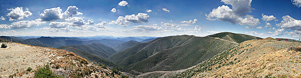
The Eastern Highlands
Great Dividing Range
The Great Dividing Range, or the Eastern Highlands, is Australia's most substantial mountain range and the third longest in the world. The range stretches more than 3,500 km from Dauan Island off the northeastern tip of Queensland, running the entire length of the eastern coastline through...
, or Great Dividing Range, lie near the eastern coast of Australia, separating the relatively narrow eastern coastal plain from the rest of the continent. These Eastern Australian temperate forests
Eastern Australian temperate forests
The Eastern Australian temperate forests are an ecoregion of open forest on uplands behind the east coast of New South Wales and southern Queensland, Australia.-Location and description:...
have the greatest relief, the most rainfall, the most abundant and varied flora and fauna, and the densest human settlement.
Between the Eastern Highlands and the Western Plateau lie the Central Lowlands, which are made up of the Great Artesian Basin and Australia's largest river systems, Murray-Darling Basin
Murray-Darling Basin
The Murray-Darling basin is a large geographical area in the interior of southeastern Australia, whose name is derived from its two major rivers, the Murray River and the Darling River. It drains one-seventh of the Australian land mass, and is currently by far the most significant agricultural...
and Lake Eyre Basin
Lake Eyre Basin
The Lake Eyre basin is a drainage basin that covers just under one-sixth of all Australia. The Lake Eyre Basin is the largest endorheic basin in Australia and amongst the largest in the world, covering about 1,200,000 square kilometres, including much of inland Queensland, large portions of South...
.
Off the eastern coast of Australia is the world's largest coral reef complex, the Great Barrier Reef
Great Barrier Reef
The Great Barrier Reef is the world'slargest reef system composed of over 2,900 individual reefs and 900 islands stretching for over 2,600 kilometres over an area of approximately...
. The State of Tasmania
Tasmania
Tasmania is an Australian island and state. It is south of the continent, separated by Bass Strait. The state includes the island of Tasmania—the 26th largest island in the world—and the surrounding islands. The state has a population of 507,626 , of whom almost half reside in the greater Hobart...
, a large and mountainous island, resides in the south-eastern corner of Australia.
Geology
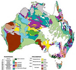
Tectonic uplift
Tectonic uplift is a geological process most often caused by plate tectonics which increases elevation. The opposite of uplift is subsidence, which results in a decrease in elevation. Uplift may be orogenic or isostatic.-Orogenic uplift:...
of mountain ranges or clashes between tectonic plates occurred mainly in Australia's early history, when it was still a part of Gondwana
Gondwana
In paleogeography, Gondwana , originally Gondwanaland, was the southernmost of two supercontinents that later became parts of the Pangaea supercontinent. It existed from approximately 510 to 180 million years ago . Gondwana is believed to have sutured between ca. 570 and 510 Mya,...
. Its highest peak is Mount Kosciuszko at 2228 metres (7,309.7 ft), which is relatively low in comparison to the highest mountains on other continents. Erosion has heavily weathered Australia's surface.
Australia is situated in the middle of the tectonic plate, and therefore currently has no active volcanism. Minor earthquakes which produce no damage occur regularly, while major earthquakes measuring greater than magnitude 6 occur on average every five years. The terrain is mostly low plateau
Plateau
In geology and earth science, a plateau , also called a high plain or tableland, is an area of highland, usually consisting of relatively flat terrain. A highly eroded plateau is called a dissected plateau...
with deserts, rangelands and a fertile plain in the southeast. Tasmania and the Australian Alps
Australian Alps
The Australian Alps are the highest mountain ranges of mainland Australia. They are located in southeastern Australia and straddle the Australian Capital Territory, south-eastern New South Wales and eastern Victoria...
do not contain any permanent icefields or glaciers, although they may have existed in the past. The Great Barrier Reef
Great Barrier Reef
The Great Barrier Reef is the world'slargest reef system composed of over 2,900 individual reefs and 900 islands stretching for over 2,600 kilometres over an area of approximately...
, by far the world's largest coral
Coral
Corals are marine animals in class Anthozoa of phylum Cnidaria typically living in compact colonies of many identical individual "polyps". The group includes the important reef builders that inhabit tropical oceans and secrete calcium carbonate to form a hard skeleton.A coral "head" is a colony of...
reef
Reef
In nautical terminology, a reef is a rock, sandbar, or other feature lying beneath the surface of the water ....
, lies a short distance off the north-east coast. Mount Augustus
Mount Augustus National Park
Mount Augustus National Park is located 852 km north of Perth, 490 km by road east of Carnarvon and 390 km northwest of Meekatharra, in the Gascoyne region of Western Australia...
, in Western Australia
Western Australia
Western Australia is a state of Australia, occupying the entire western third of the Australian continent. It is bounded by the Indian Ocean to the north and west, the Great Australian Bight and Indian Ocean to the south, the Northern Territory to the north-east and South Australia to the south-east...
, is the largest monolith
Monolith
A monolith is a geological feature such as a mountain, consisting of a single massive stone or rock, or a single piece of rock placed as, or within, a monument...
in the world.
Regions
The Australian continental landmassLandmass
A landmass is a contiguous area of land surrounded by ocean. Although it may be most often written as one word to distinguish it from the usage "land mass"—the measure of land area—it is also used as two words.Landmasses include:*supercontinents...
consists of 6 distinct landform divisions.
These are:
- The Eastern Highlands—including the Great Dividing Range, the fertile Brigalow Belt strip of grassland behind the east coast, and the Eastern Uplands
- The Eastern alluvial Plains and Lowlands—Murray Darling basin covers southern part, also includes parts of the Lake Eyre Basin and extends to the Gulf of CarpentariaGulf of CarpentariaThe Gulf of Carpentaria is a large, shallow sea enclosed on three sides by northern Australia and bounded on the north by the Arafura Sea...
- The South Australian Highlands—including the Flinders Range, Eyre PeninsulaEyre PeninsulaEyre Peninsula is a triangular peninsula in South Australia. It is bounded on the east by Spencer Gulf, the west by the Great Australian Bight, and the north by the Gawler Ranges. It is named after explorer Edward John Eyre who explored some of it in 1839-1841. The coastline was first explored by...
and Yorke PeninsulaYorke PeninsulaThe Yorke Peninsula is a peninsula located north-west and west of Adelaide in South Australia, Australia, between Spencer Gulf on the west and Gulf St Vincent on the east. It has geographic coordinates of... - The Western Plateau—including the Nullarbor PlainNullarbor PlainThe Nullarbor Plain is part of the area of flat, almost treeless, arid or semi-arid country of southern Australia, located on the Great Australian Bight coast with the Great Victoria Desert to its north. It is the world's largest single piece of limestone, and occupies an area of about...
- The Central Deserts
- Northern Plateau and Basins—including the Top EndTop EndThe Top End of northern Australia is the second northernmost point on the continent. It covers a rather vaguely-defined area of perhaps 400,000 square kilometres behind the northern coast from the Northern Territory capital of Darwin across to Arnhem Land with the Indian Ocean on the west, the...
Hydrology
Because much of Australia's interior is arid, the low average annual rainfall means interior rivers are often dry and lakes empty. The headwaters of some waterways are located in tropical regions where summer rains create a high rate of dischargeDischarge (hydrology)
In hydrology, discharge is the volume rate of water flow, including any suspended solids , dissolved chemical species and/or biologic material , which is transported through a given cross-sectional area...
. Flood events drastically alter the dry environment in which the ecology of central Australia has had to adapt to the boom and bust
Boom and bust
A credit boom-bust cycle is an episode characterized by a sustained increase in several economics indicators followed by a sharp and rapid contraction. Commonly the boom is driven by a rapid expansion of credit to the private sector accompanied with rising prices of commodities and stock market index...
cycle.
The Great Artesian Basin
Great Artesian Basin
The Great Artesian Basin provides the only reliable source of freshwater through much of inland Australia. The basin is the largest and deepest artesian basin in the world, stretching over a total of , with temperatures measured ranging from 30°C to 100°C...
is an important source of water
Water
Water is a chemical substance with the chemical formula H2O. A water molecule contains one oxygen and two hydrogen atoms connected by covalent bonds. Water is a liquid at ambient conditions, but it often co-exists on Earth with its solid state, ice, and gaseous state . Water also exists in a...
, the world's largest and deepest fresh water basin
Drainage basin
A drainage basin is an extent or an area of land where surface water from rain and melting snow or ice converges to a single point, usually the exit of the basin, where the waters join another waterbody, such as a river, lake, reservoir, estuary, wetland, sea, or ocean...
. Access to water from the basin has led to the expansion of grazing into areas that were previously far too dry for livestock. Towns and cities across the country sometimes face major water storage and usage crisis in which restrictions and other measures are implemented to reduce water consumption
Consumption (economics)
Consumption is a common concept in economics, and gives rise to derived concepts such as consumer debt. Generally, consumption is defined in part by comparison to production. But the precise definition can vary because different schools of economists define production quite differently...
. Water restrictions are based on a gradient of activities that become progressively banned as the situation worsens.
Billabong
Billabong
Billabong is an Australian English word meaning a small lake, specifically an oxbow lake, a section of still water adjacent to a river, cut off by a change in the watercourse. Billabongs are usually formed when the path of a creek or river changes, leaving the former branch with a dead end...
s is the Australian name given to oxbow lake
Oxbow lake
An oxbow lake is a U-shaped body of water formed when a wide meander from the main stem of a river is cut off to create a lake. This landform is called an oxbow lake for the distinctive curved shape, named after part of a yoke for oxen. In Australia, an oxbow lake is called a billabong, derived...
s that can form along a meandering river's course. In a world-wide comparison of height, Australia's waterfall
Waterfall
A waterfall is a place where flowing water rapidly drops in elevation as it flows over a steep region or a cliff.-Formation:Waterfalls are commonly formed when a river is young. At these times the channel is often narrow and deep. When the river courses over resistant bedrock, erosion happens...
s are relatively insignificant, with the longest drop ranked 135th according to the World Waterfall Database.
Political geography
Australia consists of six states, two major mainland territories, and other minor territories. The states are New South WalesNew South Wales
New South Wales is a state of :Australia, located in the east of the country. It is bordered by Queensland, Victoria and South Australia to the north, south and west respectively. To the east, the state is bordered by the Tasman Sea, which forms part of the Pacific Ocean. New South Wales...
, Queensland
Queensland
Queensland is a state of Australia, occupying the north-eastern section of the mainland continent. It is bordered by the Northern Territory, South Australia and New South Wales to the west, south-west and south respectively. To the east, Queensland is bordered by the Coral Sea and Pacific Ocean...
, South Australia
South Australia
South Australia is a state of Australia in the southern central part of the country. It covers some of the most arid parts of the continent; with a total land area of , it is the fourth largest of Australia's six states and two territories.South Australia shares borders with all of the mainland...
, Tasmania
Tasmania
Tasmania is an Australian island and state. It is south of the continent, separated by Bass Strait. The state includes the island of Tasmania—the 26th largest island in the world—and the surrounding islands. The state has a population of 507,626 , of whom almost half reside in the greater Hobart...
, Victoria
Victoria (Australia)
Victoria is the second most populous state in Australia. Geographically the smallest mainland state, Victoria is bordered by New South Wales, South Australia, and Tasmania on Boundary Islet to the north, west and south respectively....
and Western Australia
Western Australia
Western Australia is a state of Australia, occupying the entire western third of the Australian continent. It is bounded by the Indian Ocean to the north and west, the Great Australian Bight and Indian Ocean to the south, the Northern Territory to the north-east and South Australia to the south-east...
. The two major mainland territories are the Northern Territory
Northern Territory
The Northern Territory is a federal territory of Australia, occupying much of the centre of the mainland continent, as well as the central northern regions...
and the Australian Capital Territory
Australian Capital Territory
The Australian Capital Territory, often abbreviated ACT, is the capital territory of the Commonwealth of Australia and is the smallest self-governing internal territory...
.
Australia also has several minor territories; the federal government administers a separate area within New South Wales, the Jervis Bay Territory
Jervis Bay Territory
The Jervis Bay Territory is a territory of the Commonwealth of Australia. It was surrendered by the state of New South Wales to the Commonwealth Government in 1915 so that the Federal capital at Canberra would have "access to the sea"....
, as a naval base and sea port for the national capital. In addition Australia has the following, inhabited, external territories: Norfolk Island
Norfolk Island
Norfolk Island is a small island in the Pacific Ocean located between Australia, New Zealand and New Caledonia. The island is part of the Commonwealth of Australia, but it enjoys a large degree of self-governance...
, Christmas Island
Christmas Island
The Territory of Christmas Island is a territory of Australia in the Indian Ocean. It is located northwest of the Western Australian city of Perth, south of the Indonesian capital, Jakarta, and ENE of the Cocos Islands....
, Cocos (Keeling) Islands
Cocos (Keeling) Islands
The Territory of the Cocos Islands, also called Cocos Islands and Keeling Islands, is a territory of Australia, located in the Indian Ocean, southwest of Christmas Island and approximately midway between Australia and Sri Lanka....
, and several largely uninhabited external territories: Ashmore and Cartier Islands
Ashmore and Cartier Islands
The Territory of the Ashmore and Cartier Islands is an external territory of Australia consisting of two groups of small low-lying uninhabited tropical islands in the Indian Ocean situated on the edge of the continental shelf north-west of Australia and south of the Indonesian island of...
, Coral Sea Islands
Coral Sea Islands
The Coral Sea Islands Territory includes a group of small and mostly uninhabited tropical islands and reefs in the Coral Sea, northeast of Queensland, Australia. The only inhabited island is Willis Island...
, Heard Island and McDonald Islands
Heard Island and McDonald Islands
The Heard Island and McDonald Islands are an Australian external territory and volcanic group of barren Antarctic islands, about two-thirds of the way from Madagascar to Antarctica. The group's overall size is in area and it has of coastline...
and the Australian Antarctic Territory
Australian Antarctic Territory
The Australian Antarctic Territory is a part of Antarctica. It was claimed by the United Kingdom and placed under the authority of the Commonwealth of Australia in 1933. It is the largest territory of Antarctica claimed by any nation...
.
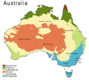
Climate
Desert
A desert is a landscape or region that receives an extremely low amount of precipitation, less than enough to support growth of most plants. Most deserts have an average annual precipitation of less than...
or semi-arid
Semi-arid
A semi-arid climate or steppe climate describes climatic regions that receive precipitation below potential evapotranspiration, but not extremely...
– 40% of the landmass is covered by sand dunes. A total of 18% of Australia's mainland is desert
Deserts of Australia
Deserts cover a large portion of the land in Australia. Most of the deserts lie in the central and north-western part of the country. The largest part of Australia is desert or semi-arid...
. Only the south-east and south-west corners have a temperate climate and moderately fertile soil. The northern part
Northern Australia
The term northern Australia is generally known to include two State and Territories, being Queensland and the Northern Territory . The part of Western Australia north of latitude 26° south—a definition widely used in law and State government policy—is also usually included...
of the country has a tropical climate: part is tropical rainforest
Rainforest
Rainforests are forests characterized by high rainfall, with definitions based on a minimum normal annual rainfall of 1750-2000 mm...
s, part grasslands, and part desert.
Rainfall is highly variable, with frequent drought
Drought in Australia
Drought in Australia is defined as rainfall over a three month period being in the lowest decile of what has been recorded for that region in the past. This definition takes into account that drought is a relative term and rainfall deficiencies need to be compared to typical rainfall patterns...
s lasting several seasons thought to be caused in part by the El Niño-Southern Oscillation
El Niño-Southern Oscillation
El Niño/La Niña-Southern Oscillation, or ENSO, is a quasiperiodic climate pattern that occurs across the tropical Pacific Ocean roughly every five years...
. Occasionally a dust storm will blanket a region or even several states and there are reports of the occasional large tornado
Tornado
A tornado is a violent, dangerous, rotating column of air that is in contact with both the surface of the earth and a cumulonimbus cloud or, in rare cases, the base of a cumulus cloud. They are often referred to as a twister or a cyclone, although the word cyclone is used in meteorology in a wider...
. Rising levels of salinity
Salinity
Salinity is the saltiness or dissolved salt content of a body of water. It is a general term used to describe the levels of different salts such as sodium chloride, magnesium and calcium sulfates, and bicarbonates...
and desertification in some areas is ravaging the landscape.
Australia's tropical/subtropical location and cold waters off the western coast make most of western Australia a hot desert with aridity, a marked feature of the greater part of the continent. These cold waters produce little moisture needed on the mainland. A 2005 study by Australian and American researchers investigated the desertification of the interior, and suggested that one explanation was related to human settler
Settler
A settler is a person who has migrated to an area and established permanent residence there, often to colonize the area. Settlers are generally people who take up residence on land and cultivate it, as opposed to nomads...
s who arrived about 50,000 years ago. Regular burning by these settlers could have prevented monsoon
Monsoon
Monsoon is traditionally defined as a seasonal reversing wind accompanied by corresponding changes in precipitation, but is now used to describe seasonal changes in atmospheric circulation and precipitation associated with the asymmetric heating of land and sea...
s from reaching interior Australia. The outback
Outback
The Outback is the vast, remote, arid area of Australia, term colloquially can refer to any lands outside the main urban areas. The term "the outback" is generally used to refer to locations that are comparatively more remote than those areas named "the bush".-Overview:The outback is home to a...
covers 70 percent of the continent.
Natural hazards
CycloneCyclone
In meteorology, a cyclone is an area of closed, circular fluid motion rotating in the same direction as the Earth. This is usually characterized by inward spiraling winds that rotate anticlockwise in the Northern Hemisphere and clockwise in the Southern Hemisphere of the Earth. Most large-scale...
s along the northern coasts; severe thunderstorm
Severe storms in Australia
Severe storms in Australia refers to the storms, including cyclones, which have caused severe damage in Australia.The first storm recorded in Australia was a shipwreck in 1622.-Australian Capital Territory:...
s, drought
Drought in Australia
Drought in Australia is defined as rainfall over a three month period being in the lowest decile of what has been recorded for that region in the past. This definition takes into account that drought is a relative term and rainfall deficiencies need to be compared to typical rainfall patterns...
s and occasional flood
Floods in Australia
This is a list of notable recorded floods that have occurred in the country of Australia.-Further reading:* Devin, L.B. and D.L. Purcell Flooding in Australia Canberra : Australian Government Publishing Service ISBN 0644026278 : .-External links:* .* ....
s; frequent bushfire
Bushfires in Australia
Bushfires in Australia are frequently occurring events during the hotter months of the year due to Australia's mostly hot, dry climate. Large areas of land are ravaged every year by bushfires, which also cause property damage and loss of life....
s.
Environment
Current issues: soil erosion from overgrazing, industrial development, urbanization, and poor farming practices; soil salinitySalinity in Australia
Soil salinity and dryland salinity are two problems degrading the environment of Australia. Salinity is a concern in most states, but especially in the south-west of Western Australia....
rising due to the use of poor quality water; desertification (partly as a result of the introduction by European settlers of Rabbits); introduced pest species; clearing for agricultural purposes threatens the natural habitat of many unique animal and plant species; the Great Barrier Reef off the northeast coast, the largest coral reef in the world, is threatened by increased shipping and its popularity as a tourist site; limited natural fresh water resources; threats from invasive species.
International agreements:
- party to: Antarctic-Environmental Protocol, Antarctic TreatyAntarctic Treaty SystemThe Antarctic Treaty and related agreements, collectively called the Antarctic Treaty System or ATS, regulate international relations with respect to Antarctica, Earth's only continent without a native human population. For the purposes of the treaty system, Antarctica is defined as all of the land...
, BiodiversityConvention on Biological DiversityThe Convention on Biological Diversity , known informally as the Biodiversity Convention, is an international legally binding treaty...
, Climate ChangeUnited Nations Framework Convention on Climate ChangeThe United Nations Framework Convention on Climate Change is an international environmental treaty produced at the United Nations Conference on Environment and Development , informally known as the Earth Summit, held in Rio de Janeiro from June 3 to 14, 1992...
, Endangered SpeciesConvention on the International Trade in Endangered Species of Wild Flora and FaunaCITES is a multilateral treaty, drafted as a result of a resolution adopted in 1963 at a meeting of members of the International Union for Conservation of Nature...
, Environmental Modification, Hazardous WastesBasel ConventionThe Basel Convention on the Control of Transboundary Movements of Hazardous Wastes and Their Disposal, usually known simply as the Basel Convention, is an international treaty that was designed to reduce the movements of hazardous waste between nations, and specifically to prevent transfer of...
, Law of the SeaUnited Nations Convention on the Law of the SeaThe United Nations Convention on the Law of the Sea , also called the Law of the Sea Convention or the Law of the Sea treaty, is the international agreement that resulted from the third United Nations Conference on the Law of the Sea , which took place from 1973 through 1982...
, Marine Dumping, Marine Life ConservationConvention on Fishing and Conservation of Living Resources of the High SeasThe Convention on Fishing and Conservation of Living Resources of the High Seas is an agreement that was designed to solve through international cooperation the problems involved in the conservation of living resources of the high seas, considering that because of the development of modern...
, Nuclear Test Ban 1963, Nuclear Non-ProliferationNuclear Non-Proliferation TreatyThe Treaty on the Non-Proliferation of Nuclear Weapons, commonly known as the Non-Proliferation Treaty or NPT, is a landmark international treaty whose objective is to prevent the spread of nuclear weapons and weapons technology, to promote cooperation in the peaceful uses of nuclear energy and to...
, Ozone Layer Protection, Ship Pollution, Tropical Timber 1994International Tropical Timber Agreement, 1994International Tropical Timber Agreement, 1994 was drafted to ensure that by the year 2000 exports of tropical timber originated from sustainably managed sources and to establish a fund to assist tropical timber producers in obtaining the resources necessary to reach this objective.It defined the...
, Wetlands, WhalingInternational Convention for the Regulation of WhalingThe International Convention for the Regulation of Whaling is an international environmental agreement signed in 1946 in order to "provide for the proper conservation of whale stocks and thus make possible the orderly development of the whaling industry"...
- signed, but not ratified: Climate Change-Kyoto ProtocolKyoto ProtocolThe Kyoto Protocol is a protocol to the United Nations Framework Convention on Climate Change , aimed at fighting global warming...
, DesertificationUnited Nations Convention to Combat DesertificationThe United Nations Convention to Combat Desertification in Those Countries Experiencing Serious Drought and/or Desertification, Particularly in Africa is a Convention to combat desertification and mitigate the effects of drought through national action programs that incorporate long-term strategies...
Antipodes
Australia is antipodalAntipodes
In geography, the antipodes of any place on Earth is the point on the Earth's surface which is diametrically opposite to it. Two points that are antipodal to one another are connected by a straight line running through the centre of the Earth....
to the North Atlantic. There are no land areas included, though Bermuda
Bermuda
Bermuda is a British overseas territory in the North Atlantic Ocean. Located off the east coast of the United States, its nearest landmass is Cape Hatteras, North Carolina, about to the west-northwest. It is about south of Halifax, Nova Scotia, Canada, and northeast of Miami, Florida...
has its antipodes just off Perth, Flores Island in the western Azores
Azores
The Archipelago of the Azores is composed of nine volcanic islands situated in the middle of the North Atlantic Ocean, and is located about west from Lisbon and about east from the east coast of North America. The islands, and their economic exclusion zone, form the Autonomous Region of the...
just off Flinders Island
Flinders Island
Flinders Island may refer to:In Australia:* Flinders Island , in the Furneaux Group, is the largest and best known* Flinders Island * Flinders Island , in the Investigator Group* Flinders Island...
, Tasmania, and Cape Verde
Cape Verde
The Republic of Cape Verde is an island country, spanning an archipelago of 10 islands located in the central Atlantic Ocean, 570 kilometres off the coast of Western Africa...
is opposite the Coral Sea
Coral Sea
The Coral Sea is a marginal sea off the northeast coast of Australia. It is bounded in the west by the east coast of Queensland, thereby including the Great Barrier Reef, in the east by Vanuatu and by New Caledonia, and in the north approximately by the southern extremity of the Solomon Islands...
.
See also
- Australasia ecozoneAustralasia ecozoneThe Australasian zone is an ecological region that is coincident, but not synonymous , with the geographic region of Australasia...
- Australia-New GuineaAustralia (continent)Australia is the world's smallest continent, comprising the mainland of Australia and proximate islands including Tasmania, New Guinea, the Aru Islands and Raja Ampat Islands...
- Extreme points of AustraliaExtreme points of Australia-Australia :* Northernmost Point – Cape York, Queensland * Southernmost Point – South Point, Wilsons Promontory, Victoria * South-westernmost Point - Cape Leeuwin, Western Australia -Australia (mainland):* Northernmost Point – Cape York, Queensland (10°41' S)* Southernmost Point – South Point,...
- List of cities in Australia by population
- List of islands of Australia
- List of lakes in Australia
- List of mountains in Australia
- List of regions in Australia
- List of rivers of Australia
- List of valleys of Australia
- List of waterfalls of Australia
- Protected areas of AustraliaProtected areas of AustraliaProtected areas of Australia include Commonwealth and off-shore protected areas managed by the Australian government, as well as protected areas within each of the six states of Australia and two self-governing territories , which are managed by the eight state and territory...
Further reading
- Miller, Gifford et al. Sensitivity of the Australian Monsoon to insolation and vegetation: Implications for human impact on continental moisture balance. Geology Vol. 33, No. 1, pp. 65–68.