

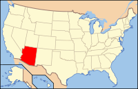
Geography of Arizona
Encyclopedia
Western United States
.The Western United States, commonly referred to as the American West or simply "the West," traditionally refers to the region comprising the westernmost states of the United States. Because the U.S. expanded westward after its founding, the meaning of the West has evolved over time...
of the United States of America
United States
The United States of America is a federal constitutional republic comprising fifty states and a federal district...
. Arizona
Arizona
Arizona ; is a state located in the southwestern region of the United States. It is also part of the western United States and the mountain west. The capital and largest city is Phoenix...
shares land borders with Utah
Utah
Utah is a state in the Western United States. It was the 45th state to join the Union, on January 4, 1896. Approximately 80% of Utah's 2,763,885 people live along the Wasatch Front, centering on Salt Lake City. This leaves vast expanses of the state nearly uninhabited, making the population the...
to the north, the Mexican
Mexico
The United Mexican States , commonly known as Mexico , is a federal constitutional republic in North America. It is bordered on the north by the United States; on the south and west by the Pacific Ocean; on the southeast by Guatemala, Belize, and the Caribbean Sea; and on the east by the Gulf of...
state of Sonora
Sonora
Sonora officially Estado Libre y Soberano de Sonora is one of the 31 states which, with the Federal District, comprise the 32 Federal Entities of Mexico. It is divided into 72 municipalities; the capital city is Hermosillo....
the south, New Mexico
New Mexico
New Mexico is a state located in the southwest and western regions of the United States. New Mexico is also usually considered one of the Mountain States. With a population density of 16 per square mile, New Mexico is the sixth-most sparsely inhabited U.S...
to the east, and Nevada
Nevada
Nevada is a state in the western, mountain west, and southwestern regions of the United States. With an area of and a population of about 2.7 million, it is the 7th-largest and 35th-most populous state. Over two-thirds of Nevada's people live in the Las Vegas metropolitan area, which contains its...
to the west. Arizona shares water borders with California
California
California is a state located on the West Coast of the United States. It is by far the most populous U.S. state, and the third-largest by land area...
and the Mexican state of Baja California
Baja California
Baja California officially Estado Libre y Soberano de Baja California is one of the 31 states which, with the Federal District, comprise the 32 Federal Entities of Mexico. It is both the northernmost and westernmost state of Mexico. Before becoming a state in 1953, the area was known as the North...
to the west along the Colorado River
Colorado River
The Colorado River , is a river in the Southwestern United States and northwestern Mexico, approximately long, draining a part of the arid regions on the western slope of the Rocky Mountains. The watershed of the Colorado River covers in parts of seven U.S. states and two Mexican states...
. Arizona is also one of the Four Corners states, at which Arizona touches Colorado
Colorado
Colorado is a U.S. state that encompasses much of the Rocky Mountains as well as the northeastern portion of the Colorado Plateau and the western edge of the Great Plains...
.
Arizona has an area of 113998 square miles (295,253 km²), making it the sixth largest U.S. state. Of Arizona's total area, 0.32% consists of water, which makes Arizona the state with the second lowest percentage of water area (New Mexico is the lowest at 0.19%). Arizona spans about 335 miles (539 km) at its widest, and 390 miles (628 km) miles at its longest, and has an average elevation of about 4000 feet (1,219.2 m). The geographic center of Arizona is located in Yavapai County, 55 miles (89 km) east-southeast of Prescott.
Political geography
Arizona is divided into 15 counties, and has 90 incorporated cities and towns. Approximately 65 percent of Arizona residents live in Maricopa CountyMaricopa County, Arizona
-2010:Whereas according to the 2010 U.S. Census Bureau:*73.0% White*5.0% Black*2.1% Native American*3.5% Asian*0.2% Native Hawaiian or Pacific Islander*3.5% Two or more races*12.7% Other races*29.6% Hispanic or Latino -2000:...
, which had a population of 3,880,181 as of the 2000 Census. Maricopa County ranks fourth among the nation's counties in terms of population, and is more populated than 24 of the U.S. states. The county seat of Maricopa County is Phoenix
Phoenix, Arizona
Phoenix is the capital, and largest city, of the U.S. state of Arizona, as well as the sixth most populated city in the United States. Phoenix is home to 1,445,632 people according to the official 2010 U.S. Census Bureau data...
, which is Arizona's largest city and capital. The next most populous county is Pima County
Pima County, Arizona
-2010:Whereas according to the 2010 U.S. Census Bureau:*74.3% White*3.5% Black*3.3% Native American*2.6% Asian*0.2% Native Hawaiian or Pacific Islander*3.7% Two or more races*12.4% Other races*34.6% Hispanic or Latino -2000:...
, which had a 2000 population of 843,746. The county seat of Pima County is Tucson
Tucson, Arizona
Tucson is a city in and the county seat of Pima County, Arizona, United States. The city is located 118 miles southeast of Phoenix and 60 miles north of the U.S.-Mexico border. The 2010 United States Census puts the city's population at 520,116 with a metropolitan area population at 1,020,200...
, where nearly all of the population is concentrated. Combined, nearly 80% of Arizona residents live in either Maricopa County or Pima County, even though the two counties make up 16% of Arizona's total area. Because of the high population of Maricopa County and Pima County, both counties are dominant in state politics.
About 15% of Arizona is privately owned, the remaining land consisting primarily of public forest and park land, Native American reservations, military institutions, and swaths of wilderness held by the Bureau of Land Management
Bureau of Land Management
The Bureau of Land Management is an agency within the United States Department of the Interior which administers America's public lands, totaling approximately , or one-eighth of the landmass of the country. The BLM also manages of subsurface mineral estate underlying federal, state and private...
. Arizona is home to 21 federally recognized tribes, which are each semi-autonomous. The large majority are part of the Navajo Nation
Navajo Nation
The Navajo Nation is a semi-autonomous Native American-governed territory covering , occupying all of northeastern Arizona, the southeastern portion of Utah, and northwestern New Mexico...
, which is the largest Native American reservation in terms of population and size. The Navajo Reservation covers all of northeastern Arizona along with portions of New Mexico and Utah, and had a population of 180,462 as of the 2000 census.
Climate
Due to the state's large area and range of elevation, there is a variety of localized climate conditions. Overall, most of Arizona receives little precipitation, and is classified as having either an aridArid
A region is said to be arid when it is characterized by a severe lack of available water, to the extent of hindering or even preventing the growth and development of plant and animal life...
or semi-arid
Semi-arid
A semi-arid climate or steppe climate describes climatic regions that receive precipitation below potential evapotranspiration, but not extremely...
climate. The northern parts of the state and the mountainous areas tend to have cooler climates, while the southern parts of the state tend to be warm year round.
Precipitation
Precipitation in Arizona is governed by elevation and the season of year. The peak periods of rainfall are during the early winter, when storm systems from the Pacific OceanPacific Ocean
The Pacific Ocean is the largest of the Earth's oceanic divisions. It extends from the Arctic in the north to the Southern Ocean in the south, bounded by Asia and Australia in the west, and the Americas in the east.At 165.2 million square kilometres in area, this largest division of the World...
cross the state, and during the summer, when moisture-bearing winds sweep into Arizona from the southeast, which obtain moisture from the Gulf of Mexico
Gulf of Mexico
The Gulf of Mexico is a partially landlocked ocean basin largely surrounded by the North American continent and the island of Cuba. It is bounded on the northeast, north and northwest by the Gulf Coast of the United States, on the southwest and south by Mexico, and on the southeast by Cuba. In...
. Summer rains tend to occur in the form of thunderstorms, which result from excessive heating of the ground and the lifting of moisture-laden air along mountain ranges. These thunderstorms can cause strong winds, brief periods of blowing dust, and infrequently cause hail. The heaviest precipitation is found in the mountain ranges of central and southeastern Arizona, while the driest conditions are found in the arid regions of southwestern Arizona.
The number of days with measurable precipitation can vary from around 70 in the Flagstaff area to 15 in the Yuma area. The highest elevations of Arizona receive up to 30 inches (762 mm) of precipitation annually, and the lower elevations receive between up to 20 inches (508 mm). The driest part of the state is the southwestern region, which receives under 3 inches (76.2 mm) of rain a year. Annual average humidity values vary from 55% in Flagstaff to 33% in Yuma. Due to the high temperatures, low humidity, and occurrence of sunshine, Arizona has high rates of evaporation. Average annual lake evaporation varies from about 80 inches (2,032 mm) in the southwestern part of the state to about 50 inches (1,270 mm) in the northeast.
Snow
While the desert parts of Arizona are renowned for their warm climates, snow is not uncommon to portions of Arizona. From November through March, when storm systems from the Pacific Ocean cross the state, heavy snow can accumulate in the mountains of central and northern Arizona. Moderate snow can occur as far south as Nogales, ArizonaNogales, Arizona
Nogales is a city in Santa Cruz County, Arizona, United States. The population was 21,017 at the 2010 census. According to 2005 Census Bureau estimates, the population of the city is 20,833. The city is the county seat of Santa Cruz County....
, which is located on the southern border with Mexico, since it experiences below-freezing nighttime temperatures during the winter.
The rims of the Grand Canyon experience snow during the winter due to their high altitudes. The South Rim of the Grand Canyon, located at an altitude averaging 7000 feet (2134 m), receives 60 inches (132 cm) of snow annually, and the North Rim of the Grand Canyon, located at an altitude over 8000 feet (2438 m) receives 144 inches (317 cm) of snow.
Temperature
Because of the dry climate and sparse cloud cover throughout the state, temperatures can vary dramatically, from day to night, and from season to season. Parts of Arizona located in the Sonoran Desert have warm daytime temperatures year round, while other parts of the state experience seasonal coldness regularly. The average daily temperatures of Yuma, which is located near Arizona's southwestern corner, range from 43° to 67 °F (6° to 19 °C) in January, and from 81° to 106 °F (27° to 41 °C) in July. In Flagstaff, located in the state's central interior, the average daily temperatures range from 14° to 41 °F (–10° to 5 °C) during January, and from 50° to 81 °F (10° to 27 °C) in July. The record high temperature for Arizona was 128 °F (53 °C), measured in Lake Havasu CityLake Havasu City, Arizona
-Demographics:As of the census of 2000, there were 41,938 people, 17,911 households, and 12,716 families residing in the city. The population density was 974.4 people per square mile . There were 23,018 housing units at an average density of 534.8 per square mile...
on June 29, 1994. The record low temperature for Arizona was -40 °F (-40 °C), measured at Hawley Lake
Hawley Lake (Arizona)
Hawley Lake is a lake and place in east-central Arizona, in the White Mountain Apache Indian Reservation, and has an elevation of .Hawley Lake is notable for being one of the coldest spots in the State of Arizona, in all seasons....
on January 7, 1971.
| Monthly normal high and low temperatures (°F) for various Arizona cities | ||||||||||||
| City | Jan | Feb | Mar | Apr | May | Jun | Jul | Aug | Sep | Oct | Nov | Dec |
|---|---|---|---|---|---|---|---|---|---|---|---|---|
| Phoenix Phoenix, Arizona Phoenix is the capital, and largest city, of the U.S. state of Arizona, as well as the sixth most populated city in the United States. Phoenix is home to 1,445,632 people according to the official 2010 U.S. Census Bureau data... |
67/46 | 71/49 | 77/54 | 85/60 | 95/69 | 104/78 | 106/83 | 105/83 | 100/77 | 89/65 | 76/53 | 66/45 |
| Tucson Tucson, Arizona Tucson is a city in and the county seat of Pima County, Arizona, United States. The city is located 118 miles southeast of Phoenix and 60 miles north of the U.S.-Mexico border. The 2010 United States Census puts the city's population at 520,116 with a metropolitan area population at 1,020,200... |
66/40 | 69/42 | 75/46 | 83/52 | 92/61 | 101/69 | 100/74 | 98/73 | 95/69 | 85/57 | 74/46 | 66/39 |
| Yuma Yuma, Arizona Yuma is a city in and the county seat of Yuma County, Arizona, United States. It is located in the southwestern corner of the state, and the population of the city was 77,515 at the 2000 census, with a 2008 Census Bureau estimated population of 90,041.... |
70/47 | 74/50 | 80/54 | 87/59 | 96/67 | 104/74 | 107/82 | 107/82 | 102/76 | 90/65 | 78/54 | 68/46 |
| Flagstaff Flagstaff, Arizona Flagstaff is a city located in northern Arizona, in the southwestern United States. In 2010, the city's population was 65,870. The population of the Metropolitan Statistical Area was at 134,421 in 2010. It is the county seat of Coconino County... |
43/17 | 46/19 | 51/24 | 59/28 | 69/35 | 79/42 | 82/51 | 79/50 | 74/42 | 63/31 | 51/23 | 43/17 |
| Prescott Prescott, Arizona Prescott is a city in Yavapai County, Arizona, USA. It was designated "Arizona's Christmas City" by Arizona Governor Rose Mofford in the late 1980s.... |
52/24 | 55/26 | 60/31 | 67/37 | 76/45 | 86/53 | 89/60 | 86/59 | 81/51 | 72/40 | 61/30 | 52/24 |
| Lake Havasu City Lake Havasu City, Arizona -Demographics:As of the census of 2000, there were 41,938 people, 17,911 households, and 12,716 families residing in the city. The population density was 974.4 people per square mile . There were 23,018 housing units at an average density of 534.8 per square mile... |
67/44 | 71/47 | 79/53 | 87/59 | 97/69 | 106/77 | 111/85 | 110/84 | 103/76 | 90/63 | 76/51 | 65/43 |
| Sierra Vista Sierra Vista, Arizona Sierra Vista is a city in Cochise County, Arizona, United States. According to 2007 Census Bureau estimates, the population of the city is 43,044.... |
61/34 | 64/37 | 70/41 | 77/47 | 85/55 | 93/63 | 92/66 | 89/65 | 87/60 | 79/51 | 69/40 | 61/33 |
| Show Low Show Low, Arizona Winters in Show Low bring highs between 45°F and 55°F , with lows usually below freezing between November and March, averaging in the 20s December through February, and in the low 30s for November and March.... |
47/23 | 51/27 | 58/31 | 66/36 | 75/45 | 84/53 | 86/59 | 83/57 | 79/51 | 68/40 | 57/30 | 47/23 |
Physiographic regions
Arizona can be divided into two major physiographic regionsPhysiographic regions of the world
The physiographic regions of the world are a means of defining the Earth's landforms into distinct regions based upon classic 1916 three-tiered approach defining divisions, provinces, and sections...
: the Colorado Plateau and the Basin and Range Province, and a transitioning zone between the two called the Transition Zone
Arizona transition zone
The Arizona transition zone, or Transition zone is a diagonal northwest-by-southeast region across central Arizona. The region is a transition from the higher elevation Colorado Plateau to the northeast in Northeast Arizona and the Basin and Range region of southwest and south regions of lower...
.
Colorado Plateau
The Colorado PlateauColorado Plateau
The Colorado Plateau, also called the Colorado Plateau Province, is a physiographic region of the Intermontane Plateaus, roughly centered on the Four Corners region of the southwestern United States. The province covers an area of 337,000 km2 within western Colorado, northwestern New Mexico,...
is a semi-arid, mostly flat-lying region ranging from 5,000 to 8,000 feet (1524 m to 2438 m) in elevation, centered on the Four Corners region. The Colorado Plateau encompasses an area of approximately 140000 square miles (362,598.3 km²). It consists of northern Arizona, except for a small portion of northwestern Arizona. The Plateau ends with the steep rock wall of the Mogollon Rim
Mogollon Rim
The Mogollon Rim is a topographical and geological feature running across the U.S. state of Arizona. It extends approximately from northern Yavapai County eastward to near the border with New Mexico.-Description:...
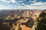
, which defines the southern edge of the plateau. The Colorado Plateau has the nickname "Red Rock Country" because of its brightly colored sedimentary rock left visible by dryness and erosion, and protected from deformation. The geology of the Colorado Plateau is exhibited by the canyons of the Colorado River
Colorado River
The Colorado River , is a river in the Southwestern United States and northwestern Mexico, approximately long, draining a part of the arid regions on the western slope of the Rocky Mountains. The watershed of the Colorado River covers in parts of seven U.S. states and two Mexican states...
, and the Grand Canyon
Grand Canyon
The Grand Canyon is a steep-sided canyon carved by the Colorado River in the United States in the state of Arizona. It is largely contained within the Grand Canyon National Park, the 15th national park in the United States...
exposes one of the most unique rock sequences
Geology of the Grand Canyon area
The geology of the Grand Canyon area exposes one of the most complete and studied sequences of rock on Earth. The nearly 40 major sedimentary rock layers exposed in the Grand Canyon and in the Grand Canyon National Park area range in age from about 200 million to nearly 2 billion years old...
in the world. The area hosts many distinctive natural features unique to Arizona, including the Grand Canyon
Grand Canyon
The Grand Canyon is a steep-sided canyon carved by the Colorado River in the United States in the state of Arizona. It is largely contained within the Grand Canyon National Park, the 15th national park in the United States...
, Antelope Canyon
Antelope Canyon
Antelope Canyon is the most-visited and most-photographed slot canyon in the American Southwest. It is located on Navajo land near Page, Arizona...
, Meteor Crater
Meteor Crater
Meteor Crater is a meteorite impact crater located approximately east of Flagstaff, near Winslow in the northern Arizona desert of the United States. Because the US Department of the Interior Division of Names commonly recognizes names of natural features derived from the nearest post office, the...
, Painted Desert
Painted Desert, Arizona
The Painted Desert is a area of badlands located in Northern Arizona in the United States. The Arizona desert stretches from the Grand Canyon National Park into the Petrified Forest National Park and runs roughly astride and just north of the Little Colorado and the Puerco Rivers...
, and the Petrified Forest
Petrified Forest National Park
Petrified Forest National Park is a United States national park in Navajo and Apache counties in northeastern Arizona. The park's headquarters are about east of Holbrook along Interstate 40 , which parallels a railroad line, the Puerco River, and historic U.S. Route 66, all crossing the park...
.
Transition Zone
The Transition ZoneArizona transition zone
The Arizona transition zone, or Transition zone is a diagonal northwest-by-southeast region across central Arizona. The region is a transition from the higher elevation Colorado Plateau to the northeast in Northeast Arizona and the Basin and Range region of southwest and south regions of lower...
is a northwest-trending escarpment
Escarpment
An escarpment is a steep slope or long cliff that occurs from erosion or faulting and separates two relatively level areas of differing elevations.-Description and variants:...
of mountainous terrain in central Arizona shaped by the intersection of the higher-level Colorado Plateau with the lower-level Basin and Range Province. The area is termed the Transition Zone because it is transitional between the two regions, with characteristics from both. The area consists of a series of rugged mountain ranges and valleys. Many of the mountains of the Transition Zone are part of the Mogollon Rim
Mogollon Rim
The Mogollon Rim is a topographical and geological feature running across the U.S. state of Arizona. It extends approximately from northern Yavapai County eastward to near the border with New Mexico.-Description:...
, a cliff, or a dramatic escarpment
Escarpment
An escarpment is a steep slope or long cliff that occurs from erosion or faulting and separates two relatively level areas of differing elevations.-Description and variants:...
in places, which extends 115 miles (185.1 km) from northern Yavapai County
Yavapai County, Arizona
-2010:Whereas according to the 2010 U.S. Census Bureau:*89.3% White*0.6% Black*1.7% Native American*0.8% Asian*0.1% Native Hawaiian or Pacific Islander*2.5% Two or more races*5.0% Other races*13.6% Hispanic or Latino -2000:...
eastward to near the border with New Mexico
New Mexico
New Mexico is a state located in the southwest and western regions of the United States. New Mexico is also usually considered one of the Mountain States. With a population density of 16 per square mile, New Mexico is the sixth-most sparsely inhabited U.S...
. The mountain ranges of the Transition Zone include the Mazatzal
Mazatzal Mountains
The Mazatzal Mountains are a mountain range in south central Arizona, about 30–45 miles northeast of Phoenix and the Phoenix metropolitan area. The origin of the name remains obscure but one possibility is that it is from the Aztec language meaning "place of the deer"...
, Santa Maria
Santa Maria Mountains
The Santa Maria Mountains are a 16-mi long mountain range in central-northwest Arizona, and in northwest Yavapai County. The range lies in a region of mesas and mountain ranges in the northwest of Arizona's transition zone...
, Sierra Ancha
Sierra Ancha
The Sierra Ancha is a mountain range in Gila County, in central Arizona. It lies between Roosevelt Lake to the south, the Tonto Basin to the west, Cherry Creek to the east, and Pleasant Valley to the north...
, and White
White Mountains (Arizona)
The White Mountains of Arizona are a mountain range and mountainous region in the eastern part of the state, near the border with New Mexico; it is a continuation from the west of the Arizona transition zone–Mogollon Rim, with the Rim ending in western New Mexico...
mountain ranges. Because of the range of elevation within the Transition Zone, climatic conditions can vary widely over small areas. The Transition Zone tends to be one of the areas of Arizona to receive heavier rainfall due to its mountainous terrain, and experiences a variation in temperature by altitude.
Basin and Range Province
The Basin and Range Province is a region occupying the southern part of Arizona, along with a strip of land consisting of the western part of the state. It is also part of a much larger region encompassing southwestern New Mexico, western Utah, and virtually all of Nevada, and extending into northwestern Mexico. The Basin and Range is characterized by steep, linear mountain ranges alternating with lengthy deserts. The mountain ranges, which poke through the lengthy desert plains surrounding them, can rise above 9000 feet (2,743.2 m), and create biological islands inhabited by cool-climate plants and animals. The geology of the Basin and Range is the result of crustal extensionRift
In geology, a rift or chasm is a place where the Earth's crust and lithosphere are being pulled apart and is an example of extensional tectonics....
of the North American plate. Due to the crustal extension, the area of the crust underneath the region is some of the thinnest in the world. The Basin and Range supplies nearly all of the copper
Copper
Copper is a chemical element with the symbol Cu and atomic number 29. It is a ductile metal with very high thermal and electrical conductivity. Pure copper is soft and malleable; an exposed surface has a reddish-orange tarnish...
mined in Arizona
Copper mining in Arizona
-Jerome:Native Americans used copper minerals of the Verde district at modern-day Jerome as pigment to decorate skin and textiles. The first European to visit the area is thought to be Spanish explorer Antonio de Espejo, who found silver at a location in central Arizona in 1583...
, and contains other minerals such as gold
Gold
Gold is a chemical element with the symbol Au and an atomic number of 79. Gold is a dense, soft, shiny, malleable and ductile metal. Pure gold has a bright yellow color and luster traditionally considered attractive, which it maintains without oxidizing in air or water. Chemically, gold is a...
, silver
Silver
Silver is a metallic chemical element with the chemical symbol Ag and atomic number 47. A soft, white, lustrous transition metal, it has the highest electrical conductivity of any element and the highest thermal conductivity of any metal...
, and barite.
Rivers
The major rivers of Arizona are the Colorado RiverColorado River
The Colorado River , is a river in the Southwestern United States and northwestern Mexico, approximately long, draining a part of the arid regions on the western slope of the Rocky Mountains. The watershed of the Colorado River covers in parts of seven U.S. states and two Mexican states...
, and one of its main tributaries, the Gila River
Gila River
The Gila River is a tributary of the Colorado River, 650 miles long, in the southwestern states of New Mexico and Arizona.-Description:...
. Nearly all of Arizona is drained by either the Colorado River or one of its tributaries.
Colorado River
The Colorado River is vital to Arizona because of the perennial dryness of the region. The river is famous because of its role in the creation of the Grand CanyonGrand Canyon
The Grand Canyon is a steep-sided canyon carved by the Colorado River in the United States in the state of Arizona. It is largely contained within the Grand Canyon National Park, the 15th national park in the United States...
, which was created over a period of six million years. Several irrigation systems divert water from the Colorado River, of which the one most vital to Arizona is the Central Arizona Project. The Central Arizona Project, which is 336 miles (541 km) long, diverts 1500000 acre.ft of water from Lake Havasu City
Lake Havasu City, Arizona
-Demographics:As of the census of 2000, there were 41,938 people, 17,911 households, and 12,716 families residing in the city. The population density was 974.4 people per square mile . There were 23,018 housing units at an average density of 534.8 per square mile...
into central and southern Arizona. The river is also utilized for hydroelectric power through various dams along the river. The dams on the Colorado River, going downstream, are the Glen Canyon Dam
Glen Canyon Dam
Glen Canyon Dam is a concrete arch dam on the Colorado River in northern Arizona in the United States, just north of Page. The dam was built to provide hydroelectricity and flow regulation from the upper Colorado River Basin to the lower. Its reservoir is called Lake Powell, and is the second...
, Hoover Dam
Hoover Dam
Hoover Dam, once known as Boulder Dam, is a concrete arch-gravity dam in the Black Canyon of the Colorado River, on the border between the US states of Arizona and Nevada. It was constructed between 1931 and 1936 during the Great Depression and was dedicated on September 30, 1935, by President...
, Davis Dam
Davis Dam
Davis Dam is a dam on the Colorado River about downstream from Hoover Dam. It stretches across the border between Arizona and Nevada. Originally called Bullhead Dam, Davis Dam was renamed after Arthur Powell Davis, who was the director of the U.S. Bureau of Reclamation from 1914 to 1932...
, Parker Dam
Parker Dam
Parker Dam is a concrete arch-gravity dam that crosses the Colorado River downstream of Hoover Dam. Built between 1934 and 1938 by the Bureau of Reclamation, it is high, of which are below the riverbed, making it "the deepest dam in the world". The dam's primary functions are to create a...
, Imperial Dam
Imperial Dam
The Imperial Diversion Dam is a concrete slab and buttress, ogee weir structure across the California/Arizona border, northeast of Yuma. Completed in the 1938, the dam retains the waters of the Colorado River into the Imperial Reservoir before desilting and diversion into the All-American Canal,...
, Laguna Dam, and the Morelos Dam
Morelos Dam
After a 1944 United States Mexico Treaty the Morelos Dam was built in 1950 across the Colorado River. It is located about below the junction of the California border and the Colorado River between the town of Los Algodones, Baja California, in northwestern Mexico and Yuma County, Arizona in the...
.
Gila River
The Gila River is 650 miles (1,046.1 km) long, and extends from southwestern New Mexico to its confluence with the Colorado River near YumaYuma, Arizona
Yuma is a city in and the county seat of Yuma County, Arizona, United States. It is located in the southwestern corner of the state, and the population of the city was 77,515 at the 2000 census, with a 2008 Census Bureau estimated population of 90,041....
. While the upper Gila River is free-flowing, the portion of the river below the Phoenix area is usually either a trickle of completely dry because of the diversion of water for irrigation. The only major dam on the Gila River is Coolidge Dam
Coolidge Dam
The Coolidge Dam is a reinforced concrete multiple dome and buttress dam southeast of Globe, Arizona on the Gila River. Built between 1924 and 1928, the Coolidge Dam was part of the San Carlos Irrigation Project. Coolidge Dam was named after the 30th US President, Calvin Coolidge and was dedicated...
, located 31 miles (49.9 km) southeast of Globe, Arizona
Globe, Arizona
Globe has an arid climate, characterized by hot summers and moderate to warm winters. Globe's arid climate is somewhat tempered by its elevation, however, leading to slightly cooler temperatures and slightly more precipitation than Phoenix or Yuma....
.
Deserts
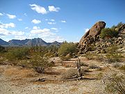
Sonoran Desert
The Sonoran DesertSonoran Desert
The Sonoran Desert is a North American desert which straddles part of the United States-Mexico border and covers large parts of the U.S. states of Arizona and California and the northwest Mexican states of Sonora, Baja California, and Baja California Sur. It is one of the largest and hottest...
covers the southwestern area of Arizona, including the cities of Phoenix
Phoenix, Arizona
Phoenix is the capital, and largest city, of the U.S. state of Arizona, as well as the sixth most populated city in the United States. Phoenix is home to 1,445,632 people according to the official 2010 U.S. Census Bureau data...
, Tucson
Tucson, Arizona
Tucson is a city in and the county seat of Pima County, Arizona, United States. The city is located 118 miles southeast of Phoenix and 60 miles north of the U.S.-Mexico border. The 2010 United States Census puts the city's population at 520,116 with a metropolitan area population at 1,020,200...
, and Yuma
Yuma, Arizona
Yuma is a city in and the county seat of Yuma County, Arizona, United States. It is located in the southwestern corner of the state, and the population of the city was 77,515 at the 2000 census, with a 2008 Census Bureau estimated population of 90,041....
. The Sonoran Desert is one of the hottest deserts of the United States, and maintains warm temperatures year round. Despite the sparse amounts of precipitation during the year, the desert is home to a diverse population of flora and fauna because it has two rainy seasons a year. Several plant populations thrive because of their specialized adaptions to the climate, and various species of cactus can be found in the wild. The Sonoran Desert is the only place in the world where the saguaro cactus grows in the wild, and the fishhook
Ferocactus wislizeni
Ferocactus wislizeni, the fishhook barrel cactus, also called Arizona barrel cactus, candy barrel cactus, and Southwestern barrel cactus, is a cylindrical barrel-shaped cactus.-Characteristics:...
, prickly pear
Opuntia
Opuntia, also known as nopales or paddle cactus , is a genus in the cactus family, Cactaceae.Currently, only prickly pears are included in this genus of about 200 species distributed throughout most of the Americas. Chollas are now separated into the genus Cylindropuntia, which some still consider...
, and organ pipe are among other types of cactus found in the Sonoran Desert.
Mojave Desert
Northwestern Arizona contains part of the Mojave DesertMojave Desert
The Mojave Desert occupies a significant portion of southeastern California and smaller parts of central California, southern Nevada, southwestern Utah and northwestern Arizona, in the United States...
, which is at a higher altitude than the Sonoran Desert. The boundaries of the Mojave Desert can be determined by the presence of Yucca brevifolia (Yucca palm), which is endemic to the desert. Unlike the Sonoran Desert, the Mojave Desert has few trees, both in number and diversity.
Painted Desert
The Painted DesertPainted Desert, Arizona
The Painted Desert is a area of badlands located in Northern Arizona in the United States. The Arizona desert stretches from the Grand Canyon National Park into the Petrified Forest National Park and runs roughly astride and just north of the Little Colorado and the Puerco Rivers...
is a broad area of badlands located on the Colorado Plateau in Northern Arizona. It covers at least 146 square miles (378.1 km²), and stretches from 30 miles (48.3 km) north of Cameron, near the Grand Canyon, ending just beyond the Petrified Forest
Petrified Forest National Park
Petrified Forest National Park is a United States national park in Navajo and Apache counties in northeastern Arizona. The park's headquarters are about east of Holbrook along Interstate 40 , which parallels a railroad line, the Puerco River, and historic U.S. Route 66, all crossing the park...
. The Painted Desert derives its name from the multitude of colored sediments and bentonite clay seen from its Chinle rock formation
Chinle Formation
The Chinle is a geologic formation that is spread across the U.S. states of northern Arizona, Nevada, Utah, western New Mexico, and western Colorado. The Chinle is controversially considered to be synonymous to the Dockum Group in eastern Colorado, eastern New Mexico, southwestern Kansas, the...
, left exposed by erosion. In the southern portion of the desert, the remains of a Triassic
Triassic
The Triassic is a geologic period and system that extends from about 250 to 200 Mya . As the first period of the Mesozoic Era, the Triassic follows the Permian and is followed by the Jurassic. Both the start and end of the Triassic are marked by major extinction events...
period coniferous forest have fossilized over millions of years. Most of the Painted Desert is located within the Navajo Nation, and is only accessible by foot.
Chihuahuan Desert
A small portion of southeastern Arizona is part of the Chihuahuan DesertChihuahuan Desert
The Chihuahuan Desert is a desert, and an ecoregion designation, that straddles the U.S.-Mexico border in the central and northern portions of the Mexican Plateau, bordered on the west by the extensive Sierra Madre Occidental range, and overlaying northern portions of the east range, the Sierra...
. Because of its higher elevation in comparison to the Sonoran Desert, it tends to have milder temperatures during the summer.
Islands
Arizona is the third largest state to not have an ocean coastline—after MontanaMontana
Montana is a state in the Western United States. The western third of Montana contains numerous mountain ranges. Smaller, "island ranges" are found in the central third of the state, for a total of 77 named ranges of the Rocky Mountains. This geographical fact is reflected in the state's name,...
and New Mexico
New Mexico
New Mexico is a state located in the southwest and western regions of the United States. New Mexico is also usually considered one of the Mountain States. With a population density of 16 per square mile, New Mexico is the sixth-most sparsely inhabited U.S...
. Despite being landlocked, Arizona does contains islands, even though the state has the third lowest amount of water at only 363.73 mi² (942 km²) after West Virginia
West Virginia
West Virginia is a state in the Appalachian and Southeastern regions of the United States, bordered by Virginia to the southeast, Kentucky to the southwest, Ohio to the northwest, Pennsylvania to the northeast and Maryland to the east...
and New Mexico
New Mexico
New Mexico is a state located in the southwest and western regions of the United States. New Mexico is also usually considered one of the Mountain States. With a population density of 16 per square mile, New Mexico is the sixth-most sparsely inhabited U.S...
. Arizona's 0.32% of water is the second lowest percentage after New Mexico's 0.2% of water. The majority of Arizona's island are in the Colorado River
Colorado River
The Colorado River , is a river in the Southwestern United States and northwestern Mexico, approximately long, draining a part of the arid regions on the western slope of the Rocky Mountains. The watershed of the Colorado River covers in parts of seven U.S. states and two Mexican states...
(mainly Lake Mead
Lake Mead
Lake Mead is the largest reservoir in the United States. It is located on the Colorado River about southeast of Las Vegas, Nevada, in the states of Nevada and Arizona. Formed by water impounded by the Hoover Dam, it extends behind the dam, holding approximately of water.-History:The lake was...
). Lake Roosevelt
Theodore Roosevelt Lake
Theodore Roosevelt Lake is a large reservoir formed by Theodore Roosevelt Dam on the Salt River in Arizona as part of the Salt River Project...
also contains a number of islands.
Mountains
Arizona is a fairly mountainous and rugged state, and is home to the world's largest contiguous ponderosa pinePonderosa Pine
Pinus ponderosa, commonly known as the Ponderosa Pine, Bull Pine, Blackjack Pine, or Western Yellow Pine, is a widespread and variable pine native to western North America. It was first described by David Douglas in 1826, from eastern Washington near present-day Spokane...
forest. Many mountain ranges exceed 9000 feet (2,743.2 m) in elevation, and some can hold snow all summer.
Arizona has 194 named mountain ranges. The highest are along the southwest margin of the Colorado Plateau
Colorado Plateau
The Colorado Plateau, also called the Colorado Plateau Province, is a physiographic region of the Intermontane Plateaus, roughly centered on the Four Corners region of the southwestern United States. The province covers an area of 337,000 km2 within western Colorado, northwestern New Mexico,...
, including the volcanic San Francisco Peaks
San Francisco Peaks
The San Francisco Peaks are a volcanic mountain range located in north central Arizona, just north of Flagstaff.The highest summit in the range, Humphreys Peak, is the highest point in the state of Arizona at in elevation. The San Francisco Peaks are the remains of an eroded stratovolcano...
just north of Flagstaff
Flagstaff, Arizona
Flagstaff is a city located in northern Arizona, in the southwestern United States. In 2010, the city's population was 65,870. The population of the Metropolitan Statistical Area was at 134,421 in 2010. It is the county seat of Coconino County...
and the White Mountains
White Mountains (Arizona)
The White Mountains of Arizona are a mountain range and mountainous region in the eastern part of the state, near the border with New Mexico; it is a continuation from the west of the Arizona transition zone–Mogollon Rim, with the Rim ending in western New Mexico...
of the Mogollon Rim
Mogollon Rim
The Mogollon Rim is a topographical and geological feature running across the U.S. state of Arizona. It extends approximately from northern Yavapai County eastward to near the border with New Mexico.-Description:...
. The Basin and Range
Basin and Range
The Basin and Range Province is a vast physiographic region defined by a unique topographic expression. Basin and Range topography is characterized by abrupt changes in elevation, alternating between narrow faulted mountain chains and flat arid valleys or basins...
region of southern and western Arizona has many rugged ranges existing as sky island
Sky island
Sky islands are mountains that are isolated by surrounding lowlands of a dramatically different environment, a situation which, in combination with the altitudinal zonation of ecosystems, has significant implications for natural habitats. Endemism, vertical migration, and relict populations are...
s in the Sonoran and Chihuahuan
Chihuahuan Desert
The Chihuahuan Desert is a desert, and an ecoregion designation, that straddles the U.S.-Mexico border in the central and northern portions of the Mexican Plateau, bordered on the west by the extensive Sierra Madre Occidental range, and overlaying northern portions of the east range, the Sierra...
deserts.
Humphreys Peak
Humphreys PeakHumphreys Peak
Humphreys Peak is the highest natural point in the U.S. state of Arizona, with an elevation of and is located within the Kachina Peaks Wilderness in the Coconino National Forest, about north of Flagstaff, Arizona. Humphreys Peak is the highest of a group of extinct volcanic peaks known as the...
(not to be confused with Mount Humphreys in the Sierra Nevada of California) in the Coconino National Forest
Coconino National Forest
The Coconino National Forest is a 1.856-million acre United States National Forest located in northern Arizona in the vicinity of Flagstaff. Originally established in 1898 as the "San Francisco Mountains National Forest Reserve", the area was designated a U.S...
is the highest summit in Arizona
Arizona
Arizona ; is a state located in the southwestern region of the United States. It is also part of the western United States and the mountain west. The capital and largest city is Phoenix...
. It is part of the San Francisco Peaks
San Francisco Peaks
The San Francisco Peaks are a volcanic mountain range located in north central Arizona, just north of Flagstaff.The highest summit in the range, Humphreys Peak, is the highest point in the state of Arizona at in elevation. The San Francisco Peaks are the remains of an eroded stratovolcano...
, a volcanic mountain range 9 miles (14.5 km) north of Flagstaff
Flagstaff, Arizona
Flagstaff is a city located in northern Arizona, in the southwestern United States. In 2010, the city's population was 65,870. The population of the Metropolitan Statistical Area was at 134,421 in 2010. It is the county seat of Coconino County...
. It tops out at 12633 feet (3,850.5 m) above sea level, and is one of the most prominent summits in the United States outside of the Rocky Mountains
Rocky Mountains
The Rocky Mountains are a major mountain range in western North America. The Rocky Mountains stretch more than from the northernmost part of British Columbia, in western Canada, to New Mexico, in the southwestern United States...
. The mountain is high enough to maintain snow cover in summer, when temperatures may not exceed 40 °F. The only maintained trail to the summit is the Humphreys Trail, a strenuous hike that starts at Arizona Snowbowl
Arizona Snowbowl
Arizona Snowbowl is an alpine ski resort located on the San Francisco Peaks, 7 miles north of Flagstaff, Arizona. The Snowbowl is a long-standing center of controversy regarding its effect on Native American sacred sites and religious practices...
.
Agassiz Peak
Simply referred to as "Agassiz", Agassiz PeakAgassiz Peak
Agassiz Peak is the second highest mountain in U.S. state of Arizona at . It is located in the San Francisco Peaks within the Coconino National Forest near Flagstaff, Arizona. The peak was named for Louis Agassiz, the celebrated naturalist....
is Mount Humphreys' sister peak and one of the San Francisco Mountains' "Big 4", or the top five highest peaks in Arizona. Its summit is 12356 feet (3,766.1 m) above sea level. The mountain is closed to climbers in the winter to protect its fragile tundra environment. This peak loses its snow usually in late May but has been known to keep snow until June.
Fremont Peak
At 11946 feet (3,641.1 m) above sea level, Fremont PeakFremont Peak (Arizona)
Fremont Peak is in the San Francisco Peaks of northern Arizona. It is the third highest point in the state of Arizona. The peak is within the Coconino National Forest and the Kachina Peaks Wilderness...
is also located in the San Francisco Mountains. This summit is relatively unknown to visitors and locals, and it is located along the Doyle Saddle, where it is not very prominent. It really isn't a summit, just a high point on the Doyle Saddle. The Humphreys Trail runs on this ridge and atop Fremont Peak.
Aubineau Peak
Aubineau Peak, the fourth highest summit in Arizona, tops out at 11818 feet (3,602.1 m) above sea level. This is a fairly steep peak, and the home of the 2005 avalanche. This mountain is on the north side of the San Francisco Mountains and is adjacent to Abineau Canyon.Ree's Peak
Ree's Peak is a much smaller peak than most of the summits in the San Francisco mountains, and at 11444 feet (3,488.1 m), it makes the northeastern tip of the range. This peak lacks alpine tundraAlpine tundra
Alpine tundra is a natural region that does not contain trees because it is at high altitude. Alpine tundra is distinguished from arctic tundra, because alpine soils are generally better drained than arctic soils...
but is home to the famed bristlecone pine
Bristlecone pine
The bristlecone pines are a small group of pine trees that are thought to reach an age far greater than that of any other single living organism known, up to nearly 5,000 years....
. The peak is distinguishable only by looking directly at it, otherwise the other summits completely flush it out.
Doyle Peak
Doyle PeakDoyle Peak
Doyle Peak is in the San Francisco Peaks of northern Arizona and is the fourth highest peak, but the sixth highest named point in the state of Arizona with an elevation of 11,460 feet. Both Aubineau Peak and Rees Peak are higher, but they do not have enough prominence from their neighbors to be...
is listed at 11440 feet (3,486.9 m), and can be seen as the summit most on the right, if you are looking at the San Francisco Mountains from the Flagstaff area. The peak can be best viewed from Shultz Pass road, and is known for its continuous aspen
Populus tremuloides
Populus tremuloides is a deciduous tree native to cooler areas of North America, commonly called quaking aspen, trembling aspen, American aspen, and Quakies,. The trees have tall trunks, up to 25 metres, with smooth pale bark, scarred with black. The glossy green leaves, dull beneath, become golden...
belt. This peak is the starting point of the Doyle Saddle, connecting Doyle Peak with Agassiz Peak.
Mount Baldy
Mount BaldyMount Baldy (Arizona)
Mount Baldy is a mountain in northeastern Arizona in the United States. It is the highest point in the White Mountains, making it the highest point in Apache County. It is the second highest point in the state after the six summits of the San Francisco Peaks near Flagstaff...
, located in Arizona's White Mountains
White Mountains (Arizona)
The White Mountains of Arizona are a mountain range and mountainous region in the eastern part of the state, near the border with New Mexico; it is a continuation from the west of the Arizona transition zone–Mogollon Rim, with the Rim ending in western New Mexico...
on the Fort Apache Indian Reservation
Fort Apache Indian Reservation
The Fort Apache Indian Reservation is an Indian reservation in Arizona, United States, encompassing parts of Navajo, Gila, and Apache counties. It is home to the federally recognized White Mountain Apache Tribe of the Fort Apache Reservation, a Western Apache tribe. It has a land area of 2,627.608...
, is an eroded mountain peak whose summit is 11391 feet (3,472 m) above sea level. Its name was given to it by locals because it lacks trees on the upper ridge, giving it a baldlike appearance. Mount Baldy is home to the Sunrise Ski Area. The mountain is not part of a range, just a single prominent peak whose flanks are gentle and peak is rounded, not rugged. This is the same for most of the White Mountains, a geologically old range once as high as the Alaska Range
Alaska Range
The Alaska Range is a relatively narrow, 650-km-long mountain range in the southcentral region of the U.S. state of Alaska, from Lake Clark at its southwest end to the White River in Canada's Yukon Territory in the southeast...
, but that has been eroded away over the eons. Mount Baldy is home to a bristlecone pine
Bristlecone pine
The bristlecone pines are a small group of pine trees that are thought to reach an age far greater than that of any other single living organism known, up to nearly 5,000 years....
forest, and some consider the White Mountains as a Rocky Mountains extension due to similar averages in elevation, tree species, animals, and weather.
Mount Ord
At 11348 feet (3,458.9 m), Mount OrdMount Ord (Apache County, Arizona)
Mount Ord is a mountain summit in Apache County, Arizona on the Fort Apache Indian Reservation. Springerville, Arizona is about to the northeast with Sunrise Park Resort to the east and Baldy Peak to the southeast....
is part of the White Mountains, and is located in Apache County on the Fort Apache Indian Reservation
Fort Apache Indian Reservation
The Fort Apache Indian Reservation is an Indian reservation in Arizona, United States, encompassing parts of Navajo, Gila, and Apache counties. It is home to the federally recognized White Mountain Apache Tribe of the Fort Apache Reservation, a Western Apache tribe. It has a land area of 2,627.608...
. Snow often stays on this mountain the longest during summer due to its high elevation and gentle north slope, snow can stick at 3 to 6 in (7.6 to 15.2 ), sometimes more, until June, only then melting into patches.