
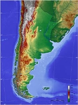
Geography of Argentina
Encyclopedia
Argentina
is a country in southern South America, situated between the Andes
in the west and the southern Atlantic Ocean in the east. It is bordered by Paraguay
and Bolivia
in the north, Brazil
and Uruguay
in the northeast and Chile
in the west.
Argentina is the second largest country of South America after Brazil, and the 8th largest country in the world. Its total area is approximately 2.7 million km². Argentina claims a section of Antarctica (Argentine Antarctica
) but has agreed to suspend sovereignty disputes in the region as a signatory to the Antarctic Treaty. Argentina also asserts claims to several South Atlantic islands administered by the United Kingdom.
6,893 m, Cerro Mercedario 6,768 m, and Cerro Aconcagua, which at 6,960 m is the tallest peak on the continent and in the entire Western Hemisphere. Both of these peaks are located near the Chile border southwest of San Juan
. The Andes region is also home to arid basins, lush foothills covered with grape vineyards, glacial mountains, and half of the Los Lagos Region
(Lake District) (the other half is in Chile). The Lake District, named for the many glacial lakes carved out of the mountains and subsequently filled by melt-water and rain, is located in the southern Andes and boasts a diverse natural landscape of glacier
s, native old growth forests, lakes, rivers, fjord
s, volcano
es, and sentinel mountains. Throughout the Andes that separate Chile and Argentina there are more than 1,800 volcanoes, 28 of which are considered to be active. These account for approximately one-fifth of the Earth's active volcanoes.
Patagonia
, the southern region of Argentina, is a combination of pastoral steppes and glacial regions. Located in this region near the Chilean border is Parc Nacional Los Glaciares (Glacier National Park ), where some 300 glaciers make up part of the Patagonian Ice Cap (21,760 km2). The ice cap, flowing into the Pacific oceans from the Andes, is the largest in the Southern Hemisphere outside of Antarctica. Thirteen of the glaciers feed lakes in the region. The Upsala glacier
, at 60 km long and 10 km wide, is the largest in South America and can only be reached by boat, since it floats in Lago Argentino. The next largest is the 4.8 km wide Perito Moreno
, which stretches about 35 km to Lago Argentino, where it forms a natural dam in the lake. Jagged mountain peaks formed from granite include Cerro Fitz Roy 3,405 m, Cerro Torre
3,102 m, and Cerro Pináculo 2,160 m.
Smaller mountain ranges also exist in central South America. These ranges cut across the center of the country and serve as the divider between the southern Patagonia region and the northeastern Pampas. From west to east these ranges are the Sierra Lihuel-Calel, the Sierra de la Ventana
, and the Sierra del Tandil.
plateau with alternating hills and depressions. It stretches across the Río Negro and Chubut
provinces, or the area from the Chubut River
north to the Negro River. The region undergoes severe climate changes between the winter and summer months. The area has lava formations and contains
many fruit and alfalfa plantations. Cattle ranchers find this area to be ideal for raising their livestock. A smaller plateau, the Atacama Plateau
, occupies the region
just east of the Andes Mountains in northern Argentina and extends east to the city of San Miguel de Tucumán.
, the second-longest river in South America after the Amazon
, flows approximately 4,900 km and forms part of the borders between Brazil and Paraguay
, and Paraguay and Argentina. Its upper reaches feature many waterfalls. It is joined by the Iguazú River
(Río Iguaçu) where it enters Argentina in the northeast. This area is well known throughout the world for the spectacular Iguazú Falls
(Cataratas Iguaçu, meaning "great water"). One of the world's great natural wonders, they are located on the border between Argentina and Brazil with two-thirds of the falls in Argentina. They include approximately 275 falls, ranging between 60 and 80 m high. These falls are higher and wider than Niagara Falls
on the border
of the United States and Canada. Other tributaries of the Paraná, which feed in from the west, are the Bermejo
, Bermejito, Salado, and Carcarañá
.
The Uruguay River
1,600 km forms part of the borders between Argentina and Brazil and Argentina and Uruguay
. It is navigable for about 300 km from its mouth to Concordia
. The 2,550 km Paraguay River
forms part of the border between Paraguay
and Argentina, and flows into the Paraná north of Corrientes
and Alto Paraná. These all join to flow into the Río de la Plata, and eventually into the Atlantic Ocean in northern Argentina. Where these rivers meet, a wide estuary is formed, which can reach a maximum width of 222 km.
In north central Argentina, Lake Mar Chiquita is supplied with its water by several rivers. The Dulce River
originates near San Miguel de Tucumán and flows southwest
into the lake. From the southwest it is also fed by the Primero
and Segundo
Rivers.
In the northern Patagonia region, the major rivers are the Colorado
and Negro Rivers, both of which rise in the Andes and flow to the Atlantic Ocean. The Colorado is fed by the Salado River, which flows from Pico Ojos del Salado in a southeasterly direction to the Colorado. Tributaries of the Salado include the Atuel, Diamante
, Tunuyán
, Desaguadero, and the San Juan, all of which originate in the northwest Andes. The Negro also has two main tributaries of its own, the Neuquén
and the Limay
. In the central Patagonia region the Chubut
rises in the Andes and flows east to form a sizable lake before making its way to the ocean. The Lake District is also coursed by its share of rivers, all originating in the mountains and flowing to the Atlantic. These include the Deseado
, Chico, Santa Cruz
, and Gallegos
Rivers.
(Lake District), on the border of Chile and Argentina in the Andes mountain region, contains many glacial lakes that are carved out of the mountains then filled by melt-water and rain. The most significant of these is Lago Buenos Aires, also known as General Carrera, located in southern Argentina and shared with Chile. It is the largest lake in the country and the fifth largest in all of South America with an average surface area of 2,240 km2. Moving south along the border one would encounter Lago San Martín, Lago Viedma, and finally Lago Argentino, the second largest lake in this region with an area of 1466 km2. Not far from Lake Buenos Aires on the Castillo Plain near Comodoro Rivadavia
is Lake Colhue Huapi.
One of the world's largest salt lakes, and the second largest lake in Argentina, is Lake Mar Chiquita (Little Sea), located in central Argentina. Its surface area varies
from year to year and season to season, but has in it wettest periods spanned 5,770 km2. The reservoir created by the Chocón dam, located on the Río Negro, is one of the country's largest manmade lakes.
. The area hosts a diverse array of flora and fauna, notably the royal water lily, silk-cotton trees, alligator
s, and capybara
, the largest rodent species in the world.
, air pollution, and water pollution. Argentina is a world leader in setting voluntary greenhouse
gas targets.
Natural hazards:
Strategic importance:
to central and coastal China, the exceptions being the north bordering Paraguay and the area around Buenos Aires, which are opposite ocean, including the coast down to Bahía Blanca
, which is close to antipodal with the Chinese port of Tianjin
. Large Chinese cities antipodal to Argentina are Canton
and Hong Kong
(with the northwest corner), Amoy
and Fuzhou
(near the border with Paraguay), Shanghai
(near the border with Uruguay), Hangzhou
, the wartime capital of Nanjing
(not far from Rosario), Changsha, Nanchang
, Wuhan
, Taiyuan
, Jinan
, Qingdao
, and the capital Beijing
(inland from Viedma). Taipei
, the capital of ROC Taiwan, is antipodal to Argentina near the Paraguayan border. Central Patagonia is largely antipodal with Mongolia
, and its southern end and Tierra del Fuego with Russia in southern Siberia.
Argentina
Argentina , officially the Argentine Republic , is the second largest country in South America by land area, after Brazil. It is constituted as a federation of 23 provinces and an autonomous city, Buenos Aires...
is a country in southern South America, situated between the Andes
Andes
The Andes is the world's longest continental mountain range. It is a continual range of highlands along the western coast of South America. This range is about long, about to wide , and of an average height of about .Along its length, the Andes is split into several ranges, which are separated...
in the west and the southern Atlantic Ocean in the east. It is bordered by Paraguay
Paraguay
Paraguay , officially the Republic of Paraguay , is a landlocked country in South America. It is bordered by Argentina to the south and southwest, Brazil to the east and northeast, and Bolivia to the northwest. Paraguay lies on both banks of the Paraguay River, which runs through the center of the...
and Bolivia
Bolivia
Bolivia officially known as Plurinational State of Bolivia , is a landlocked country in central South America. It is the poorest country in South America...
in the north, Brazil
Brazil
Brazil , officially the Federative Republic of Brazil , is the largest country in South America. It is the world's fifth largest country, both by geographical area and by population with over 192 million people...
and Uruguay
Uruguay
Uruguay ,officially the Oriental Republic of Uruguay,sometimes the Eastern Republic of Uruguay; ) is a country in the southeastern part of South America. It is home to some 3.5 million people, of whom 1.8 million live in the capital Montevideo and its metropolitan area...
in the northeast and Chile
Chile
Chile ,officially the Republic of Chile , is a country in South America occupying a long, narrow coastal strip between the Andes mountains to the east and the Pacific Ocean to the west. It borders Peru to the north, Bolivia to the northeast, Argentina to the east, and the Drake Passage in the far...
in the west.
Argentina is the second largest country of South America after Brazil, and the 8th largest country in the world. Its total area is approximately 2.7 million km². Argentina claims a section of Antarctica (Argentine Antarctica
Argentine Antarctica
Argentine Antarctica is a sector of Antarctica claimed by Argentina as part of its national territory. The Argentine Antarctic region, consisting of the Antarctic Peninsula and a triangular section extending to the South Pole, is delimited by the 25° West and 74° West meridians and the 60° South...
) but has agreed to suspend sovereignty disputes in the region as a signatory to the Antarctic Treaty. Argentina also asserts claims to several South Atlantic islands administered by the United Kingdom.
Geographical zones
The country's provinces are divided in 7 zones regarding climate and terrain. From North to South, West to East:- Argentine NorthwestArgentine NorthwestThe Argentine Northwest is a region of Argentina composed by the provinces of Catamarca, Jujuy, Salta, Santiago del Estero and Tucumán.-Geography:The region had 5 different biomes:* Sub-Andean humid Sierras of the east...
: JujuyJujuy ProvinceJujuy is a province of Argentina, located in the extreme northwest of the country, at the borders with Chile and Bolivia. The only neighboring Argentine province is Salta to the east and south.-History:...
, SaltaSalta ProvinceSalta is a province of Argentina, located in the northwest of the country. Neighboring provinces are from the east clockwise Formosa, Chaco, Santiago del Estero, Tucumán and Catamarca. It also surrounds Jujuy...
, TucumánTucumán ProvinceTucumán is the most densely populated, and the smallest by land area, of the provinces of Argentina. Located in the northwest of the country, the capital is San Miguel de Tucumán, often shortened to Tucumán. Neighboring provinces are, clockwise from the north: Salta, Santiago del Estero and...
, CatamarcaCatamarca ProvinceCatamarca is a province of Argentina, located in the northwest of the country. The province has a population of 334,568 as per the , and covers an area of 102,602 km². Its literacy rate is 95.5%. Neighbouring provinces are : Salta, Tucumán, Santiago del Estero, Córdoba, and La Rioja...
, La Rioja - Gran ChacoGran ChacoThe Gran Chaco is a sparsely populated, hot and semi-arid lowland region of the Río de la Plata basin, divided among eastern Bolivia, Paraguay, northern Argentina and a portion of the Brazilian states of Mato Grosso and Mato Grosso do Sul, where it is connected with the Pantanal region...
: FormosaFormosa ProvinceFormosa Province is in northeastern Argentina, part of the Gran Chaco Region. Its northeast end touches Asunción, Paraguay, and borders the provinces of Chaco and Salta to its south and west, respectively...
, ChacoChaco ProvinceChaco is an Argentine province located in the north of the country, near the border with Paraguay. Its capital is Resistencia on the Paraná River opposite the city of Corrientes...
, Santiago del EsteroSantiago del Estero ProvinceSantiago del Estero is a province of Argentina, located in the north of the country. Neighbouring provinces are from the north clockwise Salta, Chaco, Santa Fe, Córdoba, Catamarca and Tucumán.-History:...
- MesopotamiaMesopotamia, ArgentinaLa Mesopotamia, Región Mesopotámica is the humid and verdant area of north-east Argentina, comprising the provinces of Misiones, Entre Ríos and Corrientes. The region called Litoral consists of the Mesopotamia and the provinces of Chaco, Formosa and Santa Fe...
: MisionesMisiones ProvinceMisiones is one of the 23 provinces of Argentina, located in the northeastern corner of the country in the Mesopotamiсa region. It is surrounded by Paraguay to the northwest, Brazil to the north, east and south, and Corrientes Province of Argentina to the southwest.- History :The province was...
, CorrientesCorrientes ProvinceCorrientes is a province in northeast Argentina, in the Mesopotamia region. It is surrounded by : Paraguay, the province of Misiones, Brazil, Uruguay, and the provinces of Entre Rios, Santa Fe and Chaco.-History:... - Central: Córdoba, Entre RíosEntre Ríos ProvinceEntre Ríos is a northeastern province of Argentina, located in the Mesopotamia region. It borders the provinces of Buenos Aires , Corrientes and Santa Fe , and Uruguay in the east....
- Cuyo: San Juan, MendozaMendoza ProvinceThe Province of Mendoza is a province of Argentina, located in the western central part of the country in the Cuyo region. It borders to the north with San Juan, the south with La Pampa and Neuquén, the east with San Luis, and to the west with the republic of Chile; the international limit is...
, San LuisSan Luis ProvinceSan Luis is a province of Argentina located near the geographical center of the country . Neighboring provinces are, from the north clockwise, La Rioja, Córdoba, La Pampa, Mendoza and San Juan.-History:... - The PampaPampaThe Pampas are the fertile South American lowlands, covering more than , that include the Argentine provinces of Buenos Aires, La Pampa, Santa Fe, Entre Ríos and Córdoba, most of Uruguay, and the southernmost Brazilian State, Rio Grande do Sul...
s: Santa FeSanta Fe ProvinceThe Invincible Province of Santa Fe, in Spanish Provincia Invencible de Santa Fe , is a province of Argentina, located in the center-east of the country. Neighboring provinces are from the north clockwise Chaco , Corrientes, Entre Ríos, Buenos Aires, Córdoba, and Santiago del Estero...
, La PampaLa Pampa ProvinceLa Pampa is a sparsely populated province of Argentina, located in the Pampas in the center of the country. Neighboring provinces are from the north clockwise San Luis, Córdoba, Buenos Aires, Río Negro, Neuquén and Mendoza.-History:...
, Buenos AiresBuenos Aires ProvinceThe Province of Buenos Aires is the largest and most populous province of Argentina. It takes the name from the city of Buenos Aires, which used to be the provincial capital until it was federalized in 1880... - PatagoniaPatagoniaPatagonia is a region located in Argentina and Chile, integrating the southernmost section of the Andes mountains to the southwest towards the Pacific ocean and from the east of the cordillera to the valleys it follows south through Colorado River towards Carmen de Patagones in the Atlantic Ocean...
: Rio NegroRío Negro ProvinceRío Negro is a province of Argentina, located at the northern edge of Patagonia. Neighboring provinces are from the south clockwise Chubut, Neuquén, Mendoza, La Pampa and Buenos Aires. To the east lies the Atlantic Ocean.Its capital is Viedma...
, NeuquénNeuquén ProvinceNeuquén is a province of Argentina, located in the west of the country, at the northern end of Patagonia. It borders Mendoza Province to the north, Rio Negro Province to the southeast, and Chile to the west...
, ChubutChubut ProvinceChubut a province in the southern part of Argentina situated between the 42nd parallel south and the 46th parallel south , the Andes range separating Argentina from Chile, and the Atlantic ocean...
, Santa Cruz, Tierra del Fuego
Land use
- Arable landArable landIn geography and agriculture, arable land is land that can be used for growing crops. It includes all land under temporary crops , temporary meadows for mowing or pasture, land under market and kitchen gardens and land temporarily fallow...
: 10.03% - Permanent crops: 0.36%
- Other: 89.61% (2005)
- Irrigated landIrrigationIrrigation may be defined as the science of artificial application of water to the land or soil. It is used to assist in the growing of agricultural crops, maintenance of landscapes, and revegetation of disturbed soils in dry areas and during periods of inadequate rainfall...
: 15,500 km² (2003)
Claims
- Land claims
- Falkland Islands
- South Georgia and the South Sandwich Islands
- Argentine AntarcticaArgentine AntarcticaArgentine Antarctica is a sector of Antarctica claimed by Argentina as part of its national territory. The Argentine Antarctic region, consisting of the Antarctic Peninsula and a triangular section extending to the South Pole, is delimited by the 25° West and 74° West meridians and the 60° South...
- Maritime claims on Argentine SeaArgentine Seathumb|150px|Argentine Sea, off the [[Atlantic Ocean|atlantic]] coast of ArgentinaThe Argentine Sea refers to the sea within the continental shelf off the Argentine mainland...
- Contiguous zone: 24 nmi (44.4 km; 27.6 mi)
- Continental shelf: 200 nmi (370.4 km; 230.2 mi) or to the edge of the continental margin
- Exclusive economic zone: 200 nmi (370.4 km; 230.2 mi)
- Territorial sea: 12 nmi (22.2 km; 13.8 mi)
Mountains and hills
The Argentinean Andes contain some of the tallest mountains in South America, including Cerro Bonete 6,872, Ojos del SaladoOjos del Salado
Nevado Ojos del Salado is a massive stratovolcano in the Andes on the Argentina-Chile border and the highest volcano in the world at . It is also the second highest mountain in the Western Hemisphere and Southern Hemisphere and the highest in Chile...
6,893 m, Cerro Mercedario 6,768 m, and Cerro Aconcagua, which at 6,960 m is the tallest peak on the continent and in the entire Western Hemisphere. Both of these peaks are located near the Chile border southwest of San Juan
San Juan, Argentina
San Juan is the capital city of the Argentine province of San Juan in the Cuyo region, located in the Tulúm Valley, west of the San Juan River, at above mean sea level, with a population of around 112,000 as per the ....
. The Andes region is also home to arid basins, lush foothills covered with grape vineyards, glacial mountains, and half of the Los Lagos Region
Los Lagos Region
Los Lagos Region is one of Chile's 15 regions, which are first order administrative divisions, and comprises four provinces: Chiloé, Llanquihue, Osorno and Palena. The region contains the country's second largest island, Chiloé, and the second largest lake, Llanquihue.Its capital is Puerto Montt;...
(Lake District) (the other half is in Chile). The Lake District, named for the many glacial lakes carved out of the mountains and subsequently filled by melt-water and rain, is located in the southern Andes and boasts a diverse natural landscape of glacier
Glacier
A glacier is a large persistent body of ice that forms where the accumulation of snow exceeds its ablation over many years, often centuries. At least 0.1 km² in area and 50 m thick, but often much larger, a glacier slowly deforms and flows due to stresses induced by its weight...
s, native old growth forests, lakes, rivers, fjord
Fjord
Geologically, a fjord is a long, narrow inlet with steep sides or cliffs, created in a valley carved by glacial activity.-Formation:A fjord is formed when a glacier cuts a U-shaped valley by abrasion of the surrounding bedrock. Glacial melting is accompanied by rebound of Earth's crust as the ice...
s, volcano
Volcano
2. Bedrock3. Conduit 4. Base5. Sill6. Dike7. Layers of ash emitted by the volcano8. Flank| 9. Layers of lava emitted by the volcano10. Throat11. Parasitic cone12. Lava flow13. Vent14. Crater15...
es, and sentinel mountains. Throughout the Andes that separate Chile and Argentina there are more than 1,800 volcanoes, 28 of which are considered to be active. These account for approximately one-fifth of the Earth's active volcanoes.
Patagonia
Patagonia
Patagonia is a region located in Argentina and Chile, integrating the southernmost section of the Andes mountains to the southwest towards the Pacific ocean and from the east of the cordillera to the valleys it follows south through Colorado River towards Carmen de Patagones in the Atlantic Ocean...
, the southern region of Argentina, is a combination of pastoral steppes and glacial regions. Located in this region near the Chilean border is Parc Nacional Los Glaciares (Glacier National Park ), where some 300 glaciers make up part of the Patagonian Ice Cap (21,760 km2). The ice cap, flowing into the Pacific oceans from the Andes, is the largest in the Southern Hemisphere outside of Antarctica. Thirteen of the glaciers feed lakes in the region. The Upsala glacier
Upsala Glacier
The Upsala Glacier is a large valley glacier in Argentina's Los Glaciares National Park. It flows out from the Southern Patagonian Ice Field, which also feeds the nearby Perito Moreno Glacier. The terminus of the glacier is at Lago Argentino...
, at 60 km long and 10 km wide, is the largest in South America and can only be reached by boat, since it floats in Lago Argentino. The next largest is the 4.8 km wide Perito Moreno
Perito Moreno Glacier
The Perito Moreno Glacier is a glacier located in the Los Glaciares National Park in the south west of Santa Cruz province, Argentina. It is one of the most important tourist attractions in the Argentine Patagonia....
, which stretches about 35 km to Lago Argentino, where it forms a natural dam in the lake. Jagged mountain peaks formed from granite include Cerro Fitz Roy 3,405 m, Cerro Torre
Cerro Torre
Cerro Torre is one of the mountains of the Southern Patagonian Ice Field in South America. It is located in a region which is disputed between Argentina and Chile, west of Cerro Chalten . The peak is the highest in a four mountain chain: the other peaks are Torre Egger , Punta Herron, and Cerro...
3,102 m, and Cerro Pináculo 2,160 m.
Smaller mountain ranges also exist in central South America. These ranges cut across the center of the country and serve as the divider between the southern Patagonia region and the northeastern Pampas. From west to east these ranges are the Sierra Lihuel-Calel, the Sierra de la Ventana
Sierra de La Ventana
Sierra de La Ventana is a picturesque village in Tornquist Partido in the southeast of the Province of Buenos Aires, Argentina. With a population of 1,819 inhabitants , it is one of the most attractive tourist centres in the Province and has numerous recreation areas and parks.The town, originally...
, and the Sierra del Tandil.
Plateaus
The Somuncurá Plateau is a basaltBasalt
Basalt is a common extrusive volcanic rock. It is usually grey to black and fine-grained due to rapid cooling of lava at the surface of a planet. It may be porphyritic containing larger crystals in a fine matrix, or vesicular, or frothy scoria. Unweathered basalt is black or grey...
plateau with alternating hills and depressions. It stretches across the Río Negro and Chubut
Chubut Province
Chubut a province in the southern part of Argentina situated between the 42nd parallel south and the 46th parallel south , the Andes range separating Argentina from Chile, and the Atlantic ocean...
provinces, or the area from the Chubut River
Chubut River
The Chubut River is located in the Patagonia region of southern Argentina. Its name comes from the Tehuelche word chupat, which means "transparent". The Argentine Chubut Province, through which the river flows, is named after it...
north to the Negro River. The region undergoes severe climate changes between the winter and summer months. The area has lava formations and contains
many fruit and alfalfa plantations. Cattle ranchers find this area to be ideal for raising their livestock. A smaller plateau, the Atacama Plateau
Puna de Atacama
The Puna de Atacama or Atacama Plateau is an arid high plateau averaging about above sea level and spanning an area of , in the Andes of northern Chile and Argentina and southwest Bolivia. Before the War of the Pacific , the region belonged to Bolivia. In 1898 it was ceded to Argentina in...
, occupies the region
just east of the Andes Mountains in northern Argentina and extends east to the city of San Miguel de Tucumán.
Rivers
Except in the Northeast there are few large rivers, and many have only seasonal flows. Nearly all watercourses drain eastward toward the Atlantic, but a large number terminate in lakes and swamps or become lost in the thirsty soils of the Pampas and Patagonia. The four major rivers systems are those that feed into the Río de la Plata estuary, those made up of the Andean streams, those of the central river system, and those of the southern system. The ParanáParaná River
The Paraná River is a river in south Central South America, running through Brazil, Paraguay and Argentina for some . It is second in length only to the Amazon River among South American rivers. The name Paraná is an abbreviation of the phrase "para rehe onáva", which comes from the Tupi language...
, the second-longest river in South America after the Amazon
Amazon River
The Amazon of South America is the second longest river in the world and by far the largest by waterflow with an average discharge greater than the next seven largest rivers combined...
, flows approximately 4,900 km and forms part of the borders between Brazil and Paraguay
Paraguay
Paraguay , officially the Republic of Paraguay , is a landlocked country in South America. It is bordered by Argentina to the south and southwest, Brazil to the east and northeast, and Bolivia to the northwest. Paraguay lies on both banks of the Paraguay River, which runs through the center of the...
, and Paraguay and Argentina. Its upper reaches feature many waterfalls. It is joined by the Iguazú River
Iguazu River
The Iguazu River is a river in Brazil and Argentina. It is an important tributary of the Paraná River. The Iguazu River is long, with a drainage basin of .-Course:...
(Río Iguaçu) where it enters Argentina in the northeast. This area is well known throughout the world for the spectacular Iguazú Falls
Iguazu Falls
Iguazu Falls, Iguassu Falls, or Iguaçu Falls are waterfalls of the Iguazu River located on the border of the Brazilian State of Paraná and the Argentine Province of Misiones. The falls divide the river into the upper and lower Iguazu. The Iguazu River originates near the city of Curitiba. It flows...
(Cataratas Iguaçu, meaning "great water"). One of the world's great natural wonders, they are located on the border between Argentina and Brazil with two-thirds of the falls in Argentina. They include approximately 275 falls, ranging between 60 and 80 m high. These falls are higher and wider than Niagara Falls
Niagara Falls
The Niagara Falls, located on the Niagara River draining Lake Erie into Lake Ontario, is the collective name for the Horseshoe Falls and the adjacent American Falls along with the comparatively small Bridal Veil Falls, which combined form the highest flow rate of any waterfalls in the world and has...
on the border
Border
Borders define geographic boundaries of political entities or legal jurisdictions, such as governments, sovereign states, federated states and other subnational entities. Some borders—such as a state's internal administrative borders, or inter-state borders within the Schengen Area—are open and...
of the United States and Canada. Other tributaries of the Paraná, which feed in from the west, are the Bermejo
Bermejo River
The Bermejo River is a river in South America that flows from Bolivia to the Paraguay River in Argentina. The river is generally called Bermejo in spite of its different names along its way, but it also has its own Native American names; in Wichí it is called Teuco, and in Guaraní it is called Ypitá...
, Bermejito, Salado, and Carcarañá
Carcarañá
Carcarañá is a city in the , located in the San Lorenzo Department, on the southern banks of the Carcarañá River, west of Rosario on National Route 9, and south of the provincial capital...
.
The Uruguay River
Uruguay River
The Uruguay River is a river in South America. It flows from north to south and makes boundary with Brazil, Argentina, and Uruguay, separating some of the Argentine provinces of the Mesopotamia from the other two countries...
1,600 km forms part of the borders between Argentina and Brazil and Argentina and Uruguay
Uruguay
Uruguay ,officially the Oriental Republic of Uruguay,sometimes the Eastern Republic of Uruguay; ) is a country in the southeastern part of South America. It is home to some 3.5 million people, of whom 1.8 million live in the capital Montevideo and its metropolitan area...
. It is navigable for about 300 km from its mouth to Concordia
Concordia, Entre Ríos
San Antonio de Padua de la Concordia is a city in the north-east of the province of Entre Ríos in the Argentine Mesopotamia. It has about 142,000 inhabitants as of the , and is the head town of the department of the same name.Concordia lies on the right-hand shore of the Uruguay River, opposite...
. The 2,550 km Paraguay River
Paraguay River
The Paraguay River is a major river in south central South America, running through Brazil, Bolivia, Paraguay, and Argentina...
forms part of the border between Paraguay
Paraguay
Paraguay , officially the Republic of Paraguay , is a landlocked country in South America. It is bordered by Argentina to the south and southwest, Brazil to the east and northeast, and Bolivia to the northwest. Paraguay lies on both banks of the Paraguay River, which runs through the center of the...
and Argentina, and flows into the Paraná north of Corrientes
Corrientes
Corrientes is the capital city of the province of Corrientes, Argentina, located on the eastern shore of the Paraná River, about from Buenos Aires and from Posadas, on National Route 12...
and Alto Paraná. These all join to flow into the Río de la Plata, and eventually into the Atlantic Ocean in northern Argentina. Where these rivers meet, a wide estuary is formed, which can reach a maximum width of 222 km.
In north central Argentina, Lake Mar Chiquita is supplied with its water by several rivers. The Dulce River
Dulce River (Argentina)
The Dulce River is the most important river in the Argentine province of Santiago del Estero....
originates near San Miguel de Tucumán and flows southwest
into the lake. From the southwest it is also fed by the Primero
Primero
Primero, Prime, Primus, Primiera, Primavista, often referred to as “Poker’s mother”, as it is the first confirmed version of a game directly related to modern day poker, is a 16th century gambling card game of which the earliest reference dates back to 1526...
and Segundo
Segundo River
The Segundo River ,, also known as Xanaes, is a river in the center-north of the province of Córdoba, Argentina. It is born in the Paravachasca Valley at the confluence of the Los Molinos and Anizacate rivers, on the eastern slopes of the Cumbres de Achala , about 2,000 m above mean sea level...
Rivers.
In the northern Patagonia region, the major rivers are the Colorado
Colorado River (Argentina)
The Colorado River is a river in the south of Argentina.The Colorado river marks most of the political limit between the provinces of Neuquén and Mendoza, and between Rio Negro and La Pampa...
and Negro Rivers, both of which rise in the Andes and flow to the Atlantic Ocean. The Colorado is fed by the Salado River, which flows from Pico Ojos del Salado in a southeasterly direction to the Colorado. Tributaries of the Salado include the Atuel, Diamante
Diamante River
The Diamante River is a river in the Argentine province of Mendoza. It is born from glaciers on the Maipo, a volcano in the Andes range in the Argentine–Chilean border, and flows east until emptying in the Desaguadero River...
, Tunuyán
Tunuyán
Tunuyán is a city in the west of the province of Mendoza, Argentina, located on the western shore of the Tunuyán River, south from the provincial capital Mendoza and east of the Chilean border. It has 42,125 inhabitants as per the , and is the head town of the Tunuyán Department...
, Desaguadero, and the San Juan, all of which originate in the northwest Andes. The Negro also has two main tributaries of its own, the Neuquén
Neuquén
Neuquén is the name of the following things:* Neuquén, Argentina* Neuquén Province* Neuquén River* Neuquén Group...
and the Limay
Limay River
The Limay River is an important river in the northwestern Argentine Patagonia . It is born at the eastern end of the Nahuel Huapi Lake and flows in a meandering path for about 380 km, collecting the waters of several tributaries, such as the Traful, the Pichileufú and the Collón Curá. It then meets...
. In the central Patagonia region the Chubut
Chubut River
The Chubut River is located in the Patagonia region of southern Argentina. Its name comes from the Tehuelche word chupat, which means "transparent". The Argentine Chubut Province, through which the river flows, is named after it...
rises in the Andes and flows east to form a sizable lake before making its way to the ocean. The Lake District is also coursed by its share of rivers, all originating in the mountains and flowing to the Atlantic. These include the Deseado
Deseado
Deseado is a 10 m sloop rigged yacht that survived about a month in the Southern Ocean and Bass Strait after being abandoned in stormy seas off Tasmania, the southern island state of Australia...
, Chico, Santa Cruz
Santa Cruz River (Argentina)
Santa Cruz River is a river from the Argentine province of Santa Cruz.The Santa Cruz begins at the shore of the Viedma and Argentino Lakes, of glacial origin and located in the Los Glaciares National Park, and runs eastwards before reaching the Atlantic Coast, north of the southern tip of South...
, and Gallegos
Gallegos River
The Gallegos River is a river in the Argentine province of Santa Cruz, on whose estuary lies Río Gallegos city, capital of the province.The river is formed at the confluence of the Rubens and Penitentes rivers, and after traveling it reaches the Atlantic Coast.On its way east, after crossing a ...
Rivers.
Lakes
The Los Lagos RegionLos Lagos Region
Los Lagos Region is one of Chile's 15 regions, which are first order administrative divisions, and comprises four provinces: Chiloé, Llanquihue, Osorno and Palena. The region contains the country's second largest island, Chiloé, and the second largest lake, Llanquihue.Its capital is Puerto Montt;...
(Lake District), on the border of Chile and Argentina in the Andes mountain region, contains many glacial lakes that are carved out of the mountains then filled by melt-water and rain. The most significant of these is Lago Buenos Aires, also known as General Carrera, located in southern Argentina and shared with Chile. It is the largest lake in the country and the fifth largest in all of South America with an average surface area of 2,240 km2. Moving south along the border one would encounter Lago San Martín, Lago Viedma, and finally Lago Argentino, the second largest lake in this region with an area of 1466 km2. Not far from Lake Buenos Aires on the Castillo Plain near Comodoro Rivadavia
Comodoro Rivadavia
Comodoro Rivadavia is a city in the Patagonian province of Chubut in southern Argentina, located on the San Jorge Gulf, an inlet of the Atlantic Ocean, at the foot of the Chenque Hill. Comodoro Rivadavia is the most important city of the San Jorge Basin....
is Lake Colhue Huapi.
One of the world's largest salt lakes, and the second largest lake in Argentina, is Lake Mar Chiquita (Little Sea), located in central Argentina. Its surface area varies
from year to year and season to season, but has in it wettest periods spanned 5,770 km2. The reservoir created by the Chocón dam, located on the Río Negro, is one of the country's largest manmade lakes.
Wetlands
Iberá, in the northeast of Argentina, is a biologically rich region, with more than sixty ponds joined to marshes and swampland. The area is extremely humid, and is home to hundreds of bird species and thousands of insects, including a wide variety of butterfliesButterfly
A butterfly is a mainly day-flying insect of the order Lepidoptera, which includes the butterflies and moths. Like other holometabolous insects, the butterfly's life cycle consists of four parts: egg, larva, pupa and adult. Most species are diurnal. Butterflies have large, often brightly coloured...
. The area hosts a diverse array of flora and fauna, notably the royal water lily, silk-cotton trees, alligator
Alligator
An alligator is a crocodilian in the genus Alligator of the family Alligatoridae. There are two extant alligator species: the American alligator and the Chinese alligator ....
s, and capybara
Capybara
The capybara , also known as capivara in Portuguese, and capibara, chigüire in Venezuela, Colombia, and Ecuador ronsoco in Peru, chigüiro, and carpincho in Spanish, is the largest living rodent in the world. Its closest relatives are agouti, chinchillas, coyphillas, and guinea pigs...
, the largest rodent species in the world.
Environment
Current issues: Environmental problems (urban and rural) typical of an industrialising economy such as soil degradation, desertificationDesertification
Desertification is the degradation of land in drylands. Caused by a variety of factors, such as climate change and human activities, desertification is one of the most significant global environmental problems.-Definitions:...
, air pollution, and water pollution. Argentina is a world leader in setting voluntary greenhouse
Greenhouse
A greenhouse is a building in which plants are grown. These structures range in size from small sheds to very large buildings...
gas targets.
Natural hazards:
- San Miguel de Tucumán and MendozaMendoza, ArgentinaMendoza is the capital city of Mendoza Province, in Argentina. It is located in the northern-central part of the province, in a region of foothills and high plains, on the eastern side of the Andes. As of the , Mendoza's population was 110,993...
areas in the Andes subject to earthquakeEarthquakeAn earthquake is the result of a sudden release of energy in the Earth's crust that creates seismic waves. The seismicity, seismism or seismic activity of an area refers to the frequency, type and size of earthquakes experienced over a period of time...
s - PamperosPampero WindsThe pampero is a burst of cold polar air from the west, southwest or south on the pampas in the south of Brazil, Argentina and Uruguay. This wind picks up during the passage of a cold front of an active low passing by. It takes the form of a squall line and there is a marked drop in temperature...
are violent windstorms that can strike the PampaPampaThe Pampas are the fertile South American lowlands, covering more than , that include the Argentine provinces of Buenos Aires, La Pampa, Santa Fe, Entre Ríos and Córdoba, most of Uruguay, and the southernmost Brazilian State, Rio Grande do Sul...
s and northeast - Heavy flooding in the MesopotamiaMesopotamia, ArgentinaLa Mesopotamia, Región Mesopotámica is the humid and verdant area of north-east Argentina, comprising the provinces of Misiones, Entre Ríos and Corrientes. The region called Litoral consists of the Mesopotamia and the provinces of Chaco, Formosa and Santa Fe...
Geographical politics
International agreements:- Party to: Antarctic Treaty, Antarctic-Environmental Protocol, BiodiversityBiodiversityBiodiversity is the degree of variation of life forms within a given ecosystem, biome, or an entire planet. Biodiversity is a measure of the health of ecosystems. Biodiversity is in part a function of climate. In terrestrial habitats, tropical regions are typically rich whereas polar regions...
, Climate ChangeUnited Nations Framework Convention on Climate ChangeThe United Nations Framework Convention on Climate Change is an international environmental treaty produced at the United Nations Conference on Environment and Development , informally known as the Earth Summit, held in Rio de Janeiro from June 3 to 14, 1992...
, DesertificationDesertificationDesertification is the degradation of land in drylands. Caused by a variety of factors, such as climate change and human activities, desertification is one of the most significant global environmental problems.-Definitions:...
, Endangered SpeciesEndangered speciesAn endangered species is a population of organisms which is at risk of becoming extinct because it is either few in numbers, or threatened by changing environmental or predation parameters...
, Environmental Modification, Hazardous Wastes, Law of the SeaLaw of the seaLaw of the sea may refer to:* United Nations Convention on the Law of the Sea* Admiralty law* The Custom of the Sea...
, Marine Dumping, Nuclear Test Ban, Ozone Layer Protection, Ship PollutionMARPOL 73/78Marpol 73/78 is the International Convention for the Prevention of Pollution From Ships, 1973 as modified by the Protocol of 1978....
, Wetlands, WhalingWhalingWhaling is the hunting of whales mainly for meat and oil. Its earliest forms date to at least 3000 BC. Various coastal communities have long histories of sustenance whaling and harvesting beached whales... - Signed, but not ratified: Climate Change-Kyoto ProtocolKyoto ProtocolThe Kyoto Protocol is a protocol to the United Nations Framework Convention on Climate Change , aimed at fighting global warming...
, Marine Life Conservation
Strategic importance:
- Location relative to sea lanes between South Atlantic and South Pacific Oceans (Strait of MagellanStrait of MagellanThe Strait of Magellan comprises a navigable sea route immediately south of mainland South America and north of Tierra del Fuego...
, Beagle ChannelBeagle Channelthumb|right|300px|Aereal view of Beagle Channel. The Chilean [[Navarino Island]] is seen in the top-right while the Argentine part of [[Isla Grande de Tierra del Fuego]] is seen at the bottom-left....
, Drake PassageDrake PassageThe Drake Passage or Mar de Hoces—Sea of Hoces—is the body of water between the southern tip of South America at Cape Horn, Chile and the South Shetland Islands of Antarctica...
)
Antipodes
Argentina is largely antipodalAntipodes
In geography, the antipodes of any place on Earth is the point on the Earth's surface which is diametrically opposite to it. Two points that are antipodal to one another are connected by a straight line running through the centre of the Earth....
to central and coastal China, the exceptions being the north bordering Paraguay and the area around Buenos Aires, which are opposite ocean, including the coast down to Bahía Blanca
Bahía Blanca
Bahía Blanca is a city located in the south-west of the province of Buenos Aires, Argentina, by the Atlantic Ocean, and seat of government of Bahía Blanca Partido. It has a population of 274,509 inhabitants according to the...
, which is close to antipodal with the Chinese port of Tianjin
Tianjin
' is a metropolis in northern China and one of the five national central cities of the People's Republic of China. It is governed as a direct-controlled municipality, one of four such designations, and is, thus, under direct administration of the central government...
. Large Chinese cities antipodal to Argentina are Canton
Guangzhou
Guangzhou , known historically as Canton or Kwangchow, is the capital and largest city of the Guangdong province in the People's Republic of China. Located in southern China on the Pearl River, about north-northwest of Hong Kong, Guangzhou is a key national transportation hub and trading port...
and Hong Kong
Hong Kong
Hong Kong is one of two Special Administrative Regions of the People's Republic of China , the other being Macau. A city-state situated on China's south coast and enclosed by the Pearl River Delta and South China Sea, it is renowned for its expansive skyline and deep natural harbour...
(with the northwest corner), Amoy
Amoy
Xiamen, or Amoy, is a city on the southeast coast of China.Amoy may also refer to:*Amoy dialect, a dialect of the Hokkien lects, which are part of the Southern Min group of Chinese languages...
and Fuzhou
Fuzhou
Fuzhou is the capital and one of the largest cities in Fujian Province, People's Republic of China. Along with the many counties of Ningde, those of Fuzhou are considered to constitute the Mindong linguistic and cultural area....
(near the border with Paraguay), Shanghai
Shanghai
Shanghai is the largest city by population in China and the largest city proper in the world. It is one of the four province-level municipalities in the People's Republic of China, with a total population of over 23 million as of 2010...
(near the border with Uruguay), Hangzhou
Hangzhou
Hangzhou , formerly transliterated as Hangchow, is the capital and largest city of Zhejiang Province in Eastern China. Governed as a sub-provincial city, and as of 2010, its entire administrative division or prefecture had a registered population of 8.7 million people...
, the wartime capital of Nanjing
Nanjing
' is the capital of Jiangsu province in China and has a prominent place in Chinese history and culture, having been the capital of China on several occasions...
(not far from Rosario), Changsha, Nanchang
Nanchang
Nanchang is the capital of Jiangxi Province in southeastern China. It is located in the north-central portion of the province. As it is bounded on the west by the Jiuling Mountains, and on the east by Poyang Lake, it is famous for its scenery, rich history and cultural sites...
, Wuhan
Wuhan
Wuhan is the capital of Hubei province, People's Republic of China, and is the most populous city in Central China. It lies at the east of the Jianghan Plain, and the intersection of the middle reaches of the Yangtze and Han rivers...
, Taiyuan
Taiyuan
Taiyuan is the capital and largest city of Shanxi province in North China. At the 2010 census, it had a total population of 4,201,591 inhabitants on 6959 km² whom 3,212,500 are urban on 1,460 km². The name of the city literally means "Great Plains", referring to the location where the Fen River...
, Jinan
Jinan
Jinan is the capital of Shandong province in Eastern China. The area of present-day Jinan has played an important role in the history of the region from the earliest beginnings of civilisation and has evolved into a major national administrative, economic, and transportation hub...
, Qingdao
Qingdao
' also known in the West by its postal map spelling Tsingtao, is a major city with a population of over 8.715 million in eastern Shandong province, Eastern China. Its built up area, made of 7 urban districts plus Jimo city, is home to about 4,346,000 inhabitants in 2010.It borders Yantai to the...
, and the capital Beijing
Beijing
Beijing , also known as Peking , is the capital of the People's Republic of China and one of the most populous cities in the world, with a population of 19,612,368 as of 2010. The city is the country's political, cultural, and educational center, and home to the headquarters for most of China's...
(inland from Viedma). Taipei
Taipei
Taipei City is the capital of the Republic of China and the central city of the largest metropolitan area of Taiwan. Situated at the northern tip of the island, Taipei is located on the Tamsui River, and is about 25 km southwest of Keelung, its port on the Pacific Ocean...
, the capital of ROC Taiwan, is antipodal to Argentina near the Paraguayan border. Central Patagonia is largely antipodal with Mongolia
Mongolia
Mongolia is a landlocked country in East and Central Asia. It is bordered by Russia to the north and China to the south, east and west. Although Mongolia does not share a border with Kazakhstan, its western-most point is only from Kazakhstan's eastern tip. Ulan Bator, the capital and largest...
, and its southern end and Tierra del Fuego with Russia in southern Siberia.
See also
- List of islands of Argentina
- List of mountains in Argentina
- List of regions in Argentina
- Protected areas of Argentina
- List of rivers of Argentina