

Geography of Angola
Encyclopedia
|
||
| Continent Continent A continent is one of several very large landmasses on Earth. They are generally identified by convention rather than any strict criteria, with seven regions commonly regarded as continents—they are : Asia, Africa, North America, South America, Antarctica, Europe, and Australia.Plate tectonics is... |
Africa Africa Africa is the world's second largest and second most populous continent, after Asia. At about 30.2 million km² including adjacent islands, it covers 6% of the Earth's total surface area and 20.4% of the total land area... |
|
| Subregion Subregion A subregion is a conceptual unit which derives from a larger region or continent and is usually based on location. Cardinal directions, such as south or southern, are commonly used to define a subregion.- United Nations subregions :... |
Southern Africa Southern Africa Southern Africa is the southernmost region of the African continent, variably defined by geography or geopolitics. Within the region are numerous territories, including the Republic of South Africa ; nowadays, the simpler term South Africa is generally reserved for the country in English.-UN... |
|
| Geographic coordinates | 12°30′S 18°30′E | |
| Area Area Area is a quantity that expresses the extent of a two-dimensional surface or shape in the plane. Area can be understood as the amount of material with a given thickness that would be necessary to fashion a model of the shape, or the amount of paint necessary to cover the surface with a single coat... - Total - Water |
Ranked 22nd 1,246,700 km² |
|
| Coastline | 1600 km | |
| Land boundaries | 5,198 km | |
| Countries bordered | DROC 2,511 km Republic of Congo 201 km Namibia Namibia Namibia, officially the Republic of Namibia , is a country in southern Africa whose western border is the Atlantic Ocean. It shares land borders with Angola and Zambia to the north, Botswana to the east and South Africa to the south and east. It gained independence from South Africa on 21 March... 1,376 km Zambia Zambia Zambia , officially the Republic of Zambia, is a landlocked country in Southern Africa. The neighbouring countries are the Democratic Republic of the Congo to the north, Tanzania to the north-east, Malawi to the east, Mozambique, Zimbabwe, Botswana and Namibia to the south, and Angola to the west.... 1,110 km |
|
| Highest point | Mount Moco Mount Moco Mount Moco, at , is the highest mountain in Angola. It is located in western Angola.-References:* Merriam-Webster's Geographical Dictionary, Third Edition. Springfield, Massachusetts: Merriam-Webster, Incorporated, 1997. ISBN -0-87779-5460-0.... , 2,620 m |
|
| Lowest point | Atlantic Ocean Atlantic Ocean The Atlantic Ocean is the second-largest of the world's oceanic divisions. With a total area of about , it covers approximately 20% of the Earth's surface and about 26% of its water surface area... , 0 m |
|
| Longest river | Congo River Congo River The Congo River is a river in Africa, and is the deepest river in the world, with measured depths in excess of . It is the second largest river in the world by volume of water discharged, though it has only one-fifth the volume of the world's largest river, the Amazon... , 4,344 m |
|
| Largest inland body of water | ||
| Terrain Terrain Terrain, or land relief, is the vertical and horizontal dimension of land surface. When relief is described underwater, the term bathymetry is used... : |
coastal lowlands, hills and mountains, high plains | |
| Natural resources | petroleum Petroleum Petroleum or crude oil is a naturally occurring, flammable liquid consisting of a complex mixture of hydrocarbons of various molecular weights and other liquid organic compounds, that are found in geologic formations beneath the Earth's surface. Petroleum is recovered mostly through oil drilling... , diamond Diamond In mineralogy, diamond is an allotrope of carbon, where the carbon atoms are arranged in a variation of the face-centered cubic crystal structure called a diamond lattice. Diamond is less stable than graphite, but the conversion rate from diamond to graphite is negligible at ambient conditions... s, iron Iron Iron is a chemical element with the symbol Fe and atomic number 26. It is a metal in the first transition series. It is the most common element forming the planet Earth as a whole, forming much of Earth's outer and inner core. It is the fourth most common element in the Earth's crust... ore, phosphates, copper Copper Copper is a chemical element with the symbol Cu and atomic number 29. It is a ductile metal with very high thermal and electrical conductivity. Pure copper is soft and malleable; an exposed surface has a reddish-orange tarnish... , feldspar Feldspar Feldspars are a group of rock-forming tectosilicate minerals which make up as much as 60% of the Earth's crust.... , gold Gold Gold is a chemical element with the symbol Au and an atomic number of 79. Gold is a dense, soft, shiny, malleable and ductile metal. Pure gold has a bright yellow color and luster traditionally considered attractive, which it maintains without oxidizing in air or water. Chemically, gold is a... , bauxite Bauxite Bauxite is an aluminium ore and is the main source of aluminium. This form of rock consists mostly of the minerals gibbsite Al3, boehmite γ-AlO, and diaspore α-AlO, in a mixture with the two iron oxides goethite and hematite, the clay mineral kaolinite, and small amounts of anatase TiO2... , uranium Uranium Uranium is a silvery-white metallic chemical element in the actinide series of the periodic table, with atomic number 92. It is assigned the chemical symbol U. A uranium atom has 92 protons and 92 electrons, of which 6 are valence electrons... |
|
| Natural hazards | occasional heavy rainfall with accompanying flood Flood A flood is an overflow of an expanse of water that submerges land. The EU Floods directive defines a flood as a temporary covering by water of land not normally covered by water... s |
|
| Environmental issues | deforestation Deforestation Deforestation is the removal of a forest or stand of trees where the land is thereafter converted to a nonforest use. Examples of deforestation include conversion of forestland to farms, ranches, or urban use.... , overgrazing Overgrazing Overgrazing occurs when plants are exposed to intensive grazing for extended periods of time, or without sufficient recovery periods. It can be caused by either livestock in poorly managed agricultural applications, or by overpopulations of native or non-native wild animals.Overgrazing reduces the... of meadows, air pollution Air pollution Air pollution is the introduction of chemicals, particulate matter, or biological materials that cause harm or discomfort to humans or other living organisms, or cause damage to the natural environment or built environment, into the atmosphere.... , waste disposal |
|
Angola
Angola
Angola, officially the Republic of Angola , is a country in south-central Africa bordered by Namibia on the south, the Democratic Republic of the Congo on the north, and Zambia on the east; its west coast is on the Atlantic Ocean with Luanda as its capital city...
is located on the western Atlantic Coast of southern Africa
Southern Africa
Southern Africa is the southernmost region of the African continent, variably defined by geography or geopolitics. Within the region are numerous territories, including the Republic of South Africa ; nowadays, the simpler term South Africa is generally reserved for the country in English.-UN...
between Namibia
Namibia
Namibia, officially the Republic of Namibia , is a country in southern Africa whose western border is the Atlantic Ocean. It shares land borders with Angola and Zambia to the north, Botswana to the east and South Africa to the south and east. It gained independence from South Africa on 21 March...
and the Republic of the Congo
Republic of the Congo
The Republic of the Congo , sometimes known locally as Congo-Brazzaville, is a state in Central Africa. It is bordered by Gabon, Cameroon, the Central African Republic, the Democratic Republic of the Congo , the Angolan exclave province of Cabinda, and the Gulf of Guinea.The region was dominated by...
. It also is bordered by the Democratic Republic of the Congo
Democratic Republic of the Congo
The Democratic Republic of the Congo is a state located in Central Africa. It is the second largest country in Africa by area and the eleventh largest in the world...
and Zambia
Zambia
Zambia , officially the Republic of Zambia, is a landlocked country in Southern Africa. The neighbouring countries are the Democratic Republic of the Congo to the north, Tanzania to the north-east, Malawi to the east, Mozambique, Zimbabwe, Botswana and Namibia to the south, and Angola to the west....
to the east. The country consists of a sparsely watered and somewhat sterile coastal plain
Coastal plain
A coastal plain is an area of flat, low-lying land adjacent to a seacoast and separated from the interior by other features. One of the world's longest coastal plains is located in eastern South America. The southwestern coastal plain of North America is notable for its species diversity...
extending inland for a distance varying from 30 to 100 mi (48.3 to 160.9 km).
Slightly inland and parallel to the coast is a belt of hills and mountains and behind those a large plateau.
Geology
- the littoralLittoralThe littoral zone is that part of a sea, lake or river that is close to the shore. In coastal environments the littoral zone extends from the high water mark, which is rarely inundated, to shoreline areas that are permanently submerged. It always includes this intertidal zone and is often used to...
zone, - the median zone formed by a series of hills more or less parallel with the coast,
- the central plateau.
The central plateau consists of ancient crystalline rocks with granite
Granite
Granite is a common and widely occurring type of intrusive, felsic, igneous rock. Granite usually has a medium- to coarse-grained texture. Occasionally some individual crystals are larger than the groundmass, in which case the texture is known as porphyritic. A granitic rock with a porphyritic...
s overlain by non-fossiliferous sandstone
Sandstone
Sandstone is a sedimentary rock composed mainly of sand-sized minerals or rock grains.Most sandstone is composed of quartz and/or feldspar because these are the most common minerals in the Earth's crust. Like sand, sandstone may be any colour, but the most common colours are tan, brown, yellow,...
s and conglomerates
Conglomerate (geology)
A conglomerate is a rock consisting of individual clasts within a finer-grained matrix that have become cemented together. Conglomerates are sedimentary rocks consisting of rounded fragments and are thus differentiated from breccias, which consist of angular clasts...
of Paleozoic
Paleozoic
The Paleozoic era is the earliest of three geologic eras of the Phanerozoic eon, spanning from roughly...
age. The outcrops are largely hidden under laterite
Laterite
Laterites are soil types rich in iron and aluminium, formed in hot and wet tropical areas. Nearly all laterites are rusty-red because of iron oxides. They develop by intensive and long-lasting weathering of the underlying parent rock...
. The median zone is composed largely of crystalline rocks with granites and some Palaeozoic unfossiliferous rocks. The littoral
Littoral
The littoral zone is that part of a sea, lake or river that is close to the shore. In coastal environments the littoral zone extends from the high water mark, which is rarely inundated, to shoreline areas that are permanently submerged. It always includes this intertidal zone and is often used to...
zone contains the only fossiliferous strata. These are of Tertiary
Tertiary
The Tertiary is a deprecated term for a geologic period 65 million to 2.6 million years ago. The Tertiary covered the time span between the superseded Secondary period and the Quaternary...
and Cretaceous
Cretaceous
The Cretaceous , derived from the Latin "creta" , usually abbreviated K for its German translation Kreide , is a geologic period and system from circa to million years ago. In the geologic timescale, the Cretaceous follows the Jurassic period and is followed by the Paleogene period of the...
ages, the latter rocks resting on a reddish sandstone of older date. The Cretaceous rocks of the Dombe Grande region (near Benguella) are of Albian
Albian
The Albian is both an age of the geologic timescale and a stage in the stratigraphic column. It is the youngest or uppermost subdivision of the Early/Lower Cretaceous epoch/series. Its approximate time range is 112.0 ± 1.0 Ma to 99.6 ± 0.9 Ma...
age and belong to the Acanthoceras mamillari zone. The beds containing Schloenbachia inflata are referable to the Gault. Rocks of Tertiary age are met with at Dombe Grande, Mossamedes and near Loanda. The sandstones with gypsum
Gypsum
Gypsum is a very soft sulfate mineral composed of calcium sulfate dihydrate, with the chemical formula CaSO4·2H2O. It is found in alabaster, a decorative stone used in Ancient Egypt. It is the second softest mineral on the Mohs Hardness Scale...
, copper
Copper
Copper is a chemical element with the symbol Cu and atomic number 29. It is a ductile metal with very high thermal and electrical conductivity. Pure copper is soft and malleable; an exposed surface has a reddish-orange tarnish...
and sulfur
Sulfur
Sulfur or sulphur is the chemical element with atomic number 16. In the periodic table it is represented by the symbol S. It is an abundant, multivalent non-metal. Under normal conditions, sulfur atoms form cyclic octatomic molecules with chemical formula S8. Elemental sulfur is a bright yellow...
of Dombe are doubtfully considered to be of Triassic
Triassic
The Triassic is a geologic period and system that extends from about 250 to 200 Mya . As the first period of the Mesozoic Era, the Triassic follows the Permian and is followed by the Jurassic. Both the start and end of the Triassic are marked by major extinction events...
age. Recent eruptive rocks, mainly basalt
Basalt
Basalt is a common extrusive volcanic rock. It is usually grey to black and fine-grained due to rapid cooling of lava at the surface of a planet. It may be porphyritic containing larger crystals in a fine matrix, or vesicular, or frothy scoria. Unweathered basalt is black or grey...
s, form a line of hills almost bare of vegetation between Benguella and Mossamedes. Nepheline basalts and liparites occur at Dombe Grande. The presence of gum copal
Gum copal
Gum copal is a resin produced by the forest tree...
in considerable quantities in the superficial rocks is characteristic of certain regions.
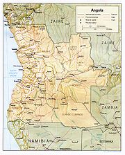
Location
Southern AfricaAfrica
Africa is the world's second largest and second most populous continent, after Asia. At about 30.2 million km² including adjacent islands, it covers 6% of the Earth's total surface area and 20.4% of the total land area...
, bordering the South Atlantic Ocean
Atlantic Ocean
The Atlantic Ocean is the second-largest of the world's oceanic divisions. With a total area of about , it covers approximately 20% of the Earth's surface and about 26% of its water surface area...
, between Namibia
Namibia
Namibia, officially the Republic of Namibia , is a country in southern Africa whose western border is the Atlantic Ocean. It shares land borders with Angola and Zambia to the north, Botswana to the east and South Africa to the south and east. It gained independence from South Africa on 21 March...
and Democratic Republic of the Congo
Democratic Republic of the Congo
The Democratic Republic of the Congo is a state located in Central Africa. It is the second largest country in Africa by area and the eleventh largest in the world...
Geographic coordinates: 12°30′S 18°30′E
Map references: Africa
Area
- total: 1246700 km² (481,354 sq mi)
- land: 1246700 km² (481,354 sq mi)
- water: 0 km² (0 sq mi)
country comparison to the world: 30
Area comparative
- AustraliaAustraliaAustralia , officially the Commonwealth of Australia, is a country in the Southern Hemisphere comprising the mainland of the Australian continent, the island of Tasmania, and numerous smaller islands in the Indian and Pacific Oceans. It is the world's sixth-largest country by total area...
comparative: smaller than the Northern TerritoryNorthern TerritoryThe Northern Territory is a federal territory of Australia, occupying much of the centre of the mainland continent, as well as the central northern regions... - CanadaCanadaCanada is a North American country consisting of ten provinces and three territories. Located in the northern part of the continent, it extends from the Atlantic Ocean in the east to the Pacific Ocean in the west, and northward into the Arctic Ocean...
comparative: slightly smaller than the Northwest TerritoriesNorthwest TerritoriesThe Northwest Territories is a federal territory of Canada.Located in northern Canada, the territory borders Canada's two other territories, Yukon to the west and Nunavut to the east, and three provinces: British Columbia to the southwest, and Alberta and Saskatchewan to the south... - United KingdomUnited KingdomThe United Kingdom of Great Britain and Northern IrelandIn the United Kingdom and Dependencies, other languages have been officially recognised as legitimate autochthonous languages under the European Charter for Regional or Minority Languages...
comparative: 5 times bigger than the UK - United StatesUnited StatesThe United States of America is a federal constitutional republic comprising fifty states and a federal district...
comparative: slightly less than twice the size of TexasTexasTexas is the second largest U.S. state by both area and population, and the largest state by area in the contiguous United States.The name, based on the Caddo word "Tejas" meaning "friends" or "allies", was applied by the Spanish to the Caddo themselves and to the region of their settlement in...
Major Cities
- Amboim (Porto Amboim)
- BailundoBailundoBailundo is a municipality and town in Huambo Province in the central highlands of Angola.In the 1990s, Bailundo was the location of the headquarters of UNITA leader Jonas Savimbi....
(Vila Teixeira da Silva) - BenguelaBenguelaBenguela is a city in western Angola, south of Luanda, and capital of Benguela Province. It lies on a bay of the same name, in 12° 33’ S., 13° 25’ E...
(São Felipe de Benguella) - port - railheadRailheadThe word railhead is a railway term with two distinct meanings, depending upon its context.Sometimes, particularly in the context of modern freight terminals, the word is used to denote a terminus of a railway line, especially if the line is not yet finished, or if the terminus interfaces with... - CaálaCaálaCaála is a town located in Huambo Province in Angola. It was known as Robert Williams town while Angola was a Portuguese colony, after the famous railroad developer and mining magnate, Sir Robert Williams. The town's last known population count was 22,010....
(Vila Robert Williams) - CalandulaCalandulaCalandula is a town and municipality in Malanje Province in Angola....
(Duque de Bragança) - CamacupaCamacupaCamacupa is a town and municipality in Bié Province in Angola.It lies on the Central Railway of Angola which heads inland from the port of Benguela.- External links :*...
(Vila General Machado) - ChibiaChibiaChibia is a town and municipality in Huíla Province in Angola.It is served by a station on the southern network of the national railway network....
(Vila João de Almeida) - GandaGandaGanda may refer to:* Ganda, Tibet, China* Ganda people of Uganda** Ganda language* Ganda Sirait, one of the big ethnic groups in Indonesia* Ganda, Angola* Ganda, the ancient Latin name of Ghent, a city in BelgiumPeople with the given name Ganda:...
(Vila Mariano Machado) - HuamboHuamboHuambo, formerly Nova Lisboa , is the capital of Huambo province in Angola. The city is located about 220 km E from Benguela and 600 km SE from Luanda. The city's last known population count was 225,268...
(Nova Lisboa) - rail - KuitoKuitoKuito is a city located in central Angola. It is the administrative capital of Bié Province. Under Portuguese rule until 1975, it was called Silva Porto. Kuito was under siege in 1993/94 and again in 1998/99 by the rebel forces from UNITA...
(Silva Porto) - KuvangoKuvangoKuvango or Cuvango is a town and municipality in Huíla Province in Angola.It is served by a station on the southern line of the national railway system....
(Vila da Ponte) - LubangoLubangoLubango is the capital city of the Angolan province of Huíla. Its last known population was 100,757. Until 1975, the city's official name was Sá da Bandeira.-Portuguese rule:...
(Sá da Bandeira) - LuenaLuena, Moxico ProvinceLuena is a town located in east central Angola. It is the administrative capital of Moxico Province. While no exact figures are available, estimates on the population of the city varies from 60,000 to 200,000 residents, including an unknown number of refugees from the Angolan Civil War that...
(Vila Luso) - MassangoMassangoMassango is a town and municipality in Malanje Province in Angola....
(Forte República) - Mbanza Congo (São Salvador do Congo)
- MenongueMenongueMenongue is a town and municipality in Cuando Cubango Province in Angola.It is the terminus of the southern railway from Namibe.-History:Menongue, formerly Serpa Pinto, was originally named for Alexandre Alberto da Rocha de Serpa Pinto, a late 19th-century Portuguese explorer of the interior of...
(Serpa Pinto) - railheadRailheadThe word railhead is a railway term with two distinct meanings, depending upon its context.Sometimes, particularly in the context of modern freight terminals, the word is used to denote a terminus of a railway line, especially if the line is not yet finished, or if the terminus interfaces with... - NamibeNamibeNamibe is the capital city of Namibe Province in Angola. It is a coastal desert city located in southwestern Angola and was founded in 1840 by the Portuguese rulers of the territory. The city's current population is 132,900...
(Moçâmedes) - port - railheadRailheadThe word railhead is a railway term with two distinct meanings, depending upon its context.Sometimes, particularly in the context of modern freight terminals, the word is used to denote a terminus of a railway line, especially if the line is not yet finished, or if the terminus interfaces with... - N'DalatandoN'dalatandoN'dalatando is a town and municipality and capital of Cuanza Norte Province in Angola.It is served by a station on the northern railway of Angolan Railways....
(Vila Salazar) - rail - N'Giva (Vila Pereira d'Eça)
- SaurimoSaurimoSaurimo is the capital of the Lunda Sul province of Angola, Saurimo has a population of approximately 200,000...
(Vila Henrique de Carvalho) - SoyoSoyoSoyo is a city located in the province of Zaire in Angola. Soyo recently became the largest oil-producing region in the country, with an estimate of .-Early history:...
(Santo António do Zaire) - SumbeSumbeSumbe is a city located in west central Angola. It is the administrative capital of Cuanza Sul Province. Its population counts about 26,000....
(Novo Redondo) - Tombua (Porto Alexandre)
- Uíje (Carmona)
- Other Towns in Angola
Land boundaries
- total: 5,198 km
- border countries: Democratic Republic of the CongoDemocratic Republic of the CongoThe Democratic Republic of the Congo is a state located in Central Africa. It is the second largest country in Africa by area and the eleventh largest in the world...
2,511 km (of which 220 km is the boundary of discontiguous Cabinda ProvinceCabinda (province)Cabinda is an exclave and province of Angola, a status that has been disputed by many political organizations in the territory. The capital city is also called Cabinda. The province is divided into four municipalities - Belize, Buco Zau, Cabinda and Cacongo.Modern Cabinda is the result of a fusion...
), Republic of the CongoRepublic of the CongoThe Republic of the Congo , sometimes known locally as Congo-Brazzaville, is a state in Central Africa. It is bordered by Gabon, Cameroon, the Central African Republic, the Democratic Republic of the Congo , the Angolan exclave province of Cabinda, and the Gulf of Guinea.The region was dominated by...
201 km, NamibiaNamibiaNamibia, officially the Republic of Namibia , is a country in southern Africa whose western border is the Atlantic Ocean. It shares land borders with Angola and Zambia to the north, Botswana to the east and South Africa to the south and east. It gained independence from South Africa on 21 March...
1,376 km, ZambiaZambiaZambia , officially the Republic of Zambia, is a landlocked country in Southern Africa. The neighbouring countries are the Democratic Republic of the Congo to the north, Tanzania to the north-east, Malawi to the east, Mozambique, Zimbabwe, Botswana and Namibia to the south, and Angola to the west....
1,110 km
Coastline: 1,600 km
Maritime claims:
- contiguous zone: 24 nmi (44.4 km)
- exclusive economic zone: 200 nmi (370.4 km)
- territorial sea: 12 nmi (22.2 km)
Climate
Like the rest of tropical Africa, Angola experiences distinct, alternating rainyMonsoon
Monsoon is traditionally defined as a seasonal reversing wind accompanied by corresponding changes in precipitation, but is now used to describe seasonal changes in atmospheric circulation and precipitation associated with the asymmetric heating of land and sea...
and dry
Dry season
The dry season is a term commonly used when describing the weather in the tropics. The weather in the tropics is dominated by the tropical rain belt, which oscillates from the northern to the southern tropics over the course of the year...
seasons. The coastal strip is tempered by the cool Benguela Current
Benguela Current
The Benguela Current is the broad, northward flowing ocean current that forms the eastern portion of the South Atlantic Ocean gyre. The current extends from roughly Cape Point in the south, to the position of the Angola-Benguela Front in the north, at around 16°S. The current is driven by the...
, resulting in a climate similar to coastal Peru
Peru
Peru , officially the Republic of Peru , is a country in western South America. It is bordered on the north by Ecuador and Colombia, on the east by Brazil, on the southeast by Bolivia, on the south by Chile, and on the west by the Pacific Ocean....
or Baja California
Baja California
Baja California officially Estado Libre y Soberano de Baja California is one of the 31 states which, with the Federal District, comprise the 32 Federal Entities of Mexico. It is both the northernmost and westernmost state of Mexico. Before becoming a state in 1953, the area was known as the North...
. It is semiarid in the South and along the coast to Luanda. There is a short rainy season lasting from February to April. Summers are hot and dry, while winters are mild. The north has a cool, dry season. The climate is greatly influenced by the prevailing winds, which arc W., S.W. and S.S.W. Two seasons are distinguished - the cool, from June to September; and the rainy, from October to May. The heaviest rainfall occurs in April, and is accompanied by violent storms.
The far north and Cabinda enjoy rain throughout much of the year.
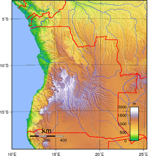
Terrain
Angola has four principal natural regions: the arid coastal lowland, stretching from Namibia to LuandaLuanda
Luanda, formerly named São Paulo da Assunção de Loanda, is the capital and largest city of Angola. Located on Angola's coast with the Atlantic Ocean, Luanda is both Angola's chief seaport and its administrative center. It has a population of at least 5 million...
and characterized by low plains and terraces; green hills and mountains, rising inland from the coast into a great escarpment; a large area of high inland plains of dry savanna
Savanna
A savanna, or savannah, is a grassland ecosystem characterized by the trees being sufficiently small or widely spaced so that the canopy does not close. The open canopy allows sufficient light to reach the ground to support an unbroken herbaceous layer consisting primarily of C4 grasses.Some...
, called the high plateau (planalto), which extends eastward and south-east from the escarpment; and rain forest in the north and in Cabinda
Cabinda (province)
Cabinda is an exclave and province of Angola, a status that has been disputed by many political organizations in the territory. The capital city is also called Cabinda. The province is divided into four municipalities - Belize, Buco Zau, Cabinda and Cacongo.Modern Cabinda is the result of a fusion...
. The highest point in Angola is Morro de Môco, at 2,620 m. Elevations generally range from 3000 to 6000 ft (914.4 to 1,828.8 m).
Coastal lowland
The coast is for the most part flat, with occasional low cliffs and bluffs of red sandstoneSandstone
Sandstone is a sedimentary rock composed mainly of sand-sized minerals or rock grains.Most sandstone is composed of quartz and/or feldspar because these are the most common minerals in the Earth's crust. Like sand, sandstone may be any colour, but the most common colours are tan, brown, yellow,...
. There is but one deep inlet of the sea - Great Fish Bay (or Baía dos Tigres
Baia dos Tigres
Baia dos Tigres is the largest island of Angola. It is situated in the Namibe Province. Its area is 98 km²....
). Farther north are Port Alexander, Little Fish Bay and Lobito Bay, while shallower bays are numerous. Lobito Bay has water sufficient to allow large ships to unload close inshore.
The coastal lowland rises from the sea in a series of low terraces. This region varies in width from about 25 kilometers near Benguela to more than 150 kilometers in the Cuanza River Valley just south of Angola's capital, Luanda, and is markedly different from Angola's highland mass. The Atlantic Ocean's cold, northwardflowing Benguela Current substantially reduces precipitation along the coast, making the region relatively arid or nearly so south of Benguela (where it forms the northern extension of the Namib Desert), and quite dry even in its northern reaches. Even where, as around Luanda, the average annual rainfall may be as much as fifty centimeters, it is not common for the rains to fail. Given this pattern of precipitation, the far south is marked by sand dunes, which give way to dry scrub along the middle coast. Portions of the northern coastal plain are covered by thick brush.
Hills and mountains
The approach to the great central plateau of Africa is marked by the west-central highlands, a series of irregular escarpmentEscarpment
An escarpment is a steep slope or long cliff that occurs from erosion or faulting and separates two relatively level areas of differing elevations.-Description and variants:...
s and cuesta
Cuesta
In structural geology and geomorphology, a cuesta is a ridge formed by gently tilted sedimentary rock strata in a homoclinal structure. Cuestas have a steep slope, where the rock layers are exposed on their edges, called an escarpment or, if more steep, a cliff...
s parallel to the coast at distances ranging from 20 kilometers to 100 kilometers inland as Tala Mugongo (4400 ft (1,341.1 m)), Chella and Vissecua (5250 ft (1,600.2 m)).
The Cuanza River divides the mountain zone into two parts. The northern part rises gradually from the coastal zone to an average elevation of 500 meters, with crests as high as 1,000 meters to 1,800 meters. South of the Cuanza River, the hills rise sharply from the coastal lowlands and form a high escarpment, extending from a point east of Luanda and running south through Namibia. The highest peak is Mount Moco
Mount Moco
Mount Moco, at , is the highest mountain in Angola. It is located in western Angola.-References:* Merriam-Webster's Geographical Dictionary, Third Edition. Springfield, Massachusetts: Merriam-Webster, Incorporated, 1997. ISBN -0-87779-5460-0....
(2620 m (8,595.8 ft)), and the escarpment is steepest in the far south in the Serra da Chella mountain range. In Benguela Province other high points are Loviti (7780 ft (2,371.3 m)), in 12° 5' S., and Mt. Elonga (7550 ft (2,301.2 m)). South of the Cuanza is the volcanic mountain Caculo-Cabaza (3300 ft (1,005.8 m)).
High plateau
The high plateau, with an altitude ranging from 4000 to 6000 ft (1,219.2 to 1,828.8 ), lies to the east of the hills and mountains and dominates Angola's terrain. It consists of well-watered, wide, rolling plains, and low hills with scanty vegetation. The surface of the plateau is typically flat or rolling, but parts of the Benguela Plateau and the Humpata Highland area of the Huíla Plateau in the south reach heights of 2,500 meters and more. The Malanje Plateau to the north rarely exceeds 1,000 meters in height. The Benguela Plateau and the coastal area in the immediate environs of Benguela and Lobito, the Bié PlateauBié Plateau
The Bié Plateau or Central Plateau of Angola is a plateau that occupies most of central Angola. The elevation of the plateau is from 1,520 m to 1,830 m....
, the Malanje Plateau, and a small section of the Huíla Plateau near the town of Lubango have long been among the most densely settled areas in Angola. In the east the tableland falls away to the basins of the Congo and Zambezi, to the south in Namibia it merges into a barren sandy desert
Desert
A desert is a landscape or region that receives an extremely low amount of precipitation, less than enough to support growth of most plants. Most deserts have an average annual precipitation of less than...
.
Drainage
The Zambezi River and several tributaries of the Congo RiverCongo River
The Congo River is a river in Africa, and is the deepest river in the world, with measured depths in excess of . It is the second largest river in the world by volume of water discharged, though it has only one-fifth the volume of the world's largest river, the Amazon...
have their sources in Angola. A large number of rivers originate in the central uplands, but their patterns of flow are diverse and their ultimate outlets varied. A number flow in a more or less westerly course to the Atlantic Ocean, providing water for irrigation in the dry coastal strip and the potential for hydroelectric power, only some of which had been realized by 1988. Two of Angola's most important rivers, the Cuanza
Cuanza River
The Cuanza River is a river in Angola. It empties into the Atlantic Ocean just south of the nation's capital, Luanda....
(Kwanza) and the Cunene
Cunene River
The Cunene River or Kunene River is a river in Southern Africa. It flows from the Angola highlands south to the border with Namibia. It then flows west along the border until it reaches the Atlantic Ocean. It is one of the few perennial rivers in the region. It is about long, with a drainage...
(Kunene), take a more indirect route to the Atlantic, the Cuanza flowing north and the Cunene flowing south before turning west. The Cuanza is the only river wholly within Angola that is navigable--for nearly 200 kilometers from its mouth- -by boats of commercially or militarily significant size. The Congo River, whose mouth and western end form a small portion of Angola's northern border with Zaire, is also navigable.
North of the Lunda Divide the Kwango and many other streams flow north from the tableland to join the Kasai River
Kasai River
The Kasai River is a tributary of the Congo River, located in central Africa. The river begins in Angola and serves as the border between Angola and the Democratic Republic of the Congo , then flows into the DRC, where it joins the Congo northeast of Kinshasa. The Kasai's tributaries include the...
(one of the largest affluents of the Congo), which in its upper course forms for fully 300 mi (482.8 km) the boundary between Angola and the Congo. South of the divide some rivers flow into the Zambezi River system and thence to the Indian Ocean, others to the Okavango River (as the Cubango River is called along the border with Namibia and in Botswana) and thence to Lake Ngami
Lake Ngami
Lake Ngami is an endorheic lake in Botswana north of the Kalahari Desert. It is seasonally filled by the Taughe River an affluent of the Okavango River system flowing out of the western side of the Okavango Delta. It is one of the fragmented remnants of the ancient Lake Makgadikgadi...
and the Okavango Swamp in Botswana. The tributaries of the Cubango River and several of the southern rivers flowing to the Atlantic are seasonal, completely dry much of the year.
Land use and hazards
Natural resources: petroleumPetroleum
Petroleum or crude oil is a naturally occurring, flammable liquid consisting of a complex mixture of hydrocarbons of various molecular weights and other liquid organic compounds, that are found in geologic formations beneath the Earth's surface. Petroleum is recovered mostly through oil drilling...
, diamond
Diamond
In mineralogy, diamond is an allotrope of carbon, where the carbon atoms are arranged in a variation of the face-centered cubic crystal structure called a diamond lattice. Diamond is less stable than graphite, but the conversion rate from diamond to graphite is negligible at ambient conditions...
s, iron
Iron
Iron is a chemical element with the symbol Fe and atomic number 26. It is a metal in the first transition series. It is the most common element forming the planet Earth as a whole, forming much of Earth's outer and inner core. It is the fourth most common element in the Earth's crust...
ore, phosphates, copper
Copper
Copper is a chemical element with the symbol Cu and atomic number 29. It is a ductile metal with very high thermal and electrical conductivity. Pure copper is soft and malleable; an exposed surface has a reddish-orange tarnish...
, feldspar
Feldspar
Feldspars are a group of rock-forming tectosilicate minerals which make up as much as 60% of the Earth's crust....
, gold
Gold
Gold is a chemical element with the symbol Au and an atomic number of 79. Gold is a dense, soft, shiny, malleable and ductile metal. Pure gold has a bright yellow color and luster traditionally considered attractive, which it maintains without oxidizing in air or water. Chemically, gold is a...
, bauxite
Bauxite
Bauxite is an aluminium ore and is the main source of aluminium. This form of rock consists mostly of the minerals gibbsite Al3, boehmite γ-AlO, and diaspore α-AlO, in a mixture with the two iron oxides goethite and hematite, the clay mineral kaolinite, and small amounts of anatase TiO2...
, uranium
Uranium
Uranium is a silvery-white metallic chemical element in the actinide series of the periodic table, with atomic number 92. It is assigned the chemical symbol U. A uranium atom has 92 protons and 92 electrons, of which 6 are valence electrons...
Land use:
- arable land: 2.65%
- permanent crops: 0.23%
- other: 97.12% (2005)
Irrigated land: 800 km² (2003 est.)
Total renewable water resources: 184 km³ (44.1 cu mi) (1987)
Freshwater withdrawal (domestic/industrial/agricultural)
- total: 0.35 km³ (0.0839694655115003 cu mi)/yr (23%/17%/60%)
- per capita: 22 m³ (28.8 cu yd)/yr (2000)
Natural hazards: locally heavy rainfall causes periodic flooding on the plateau
Environment - current issues
Overuse of pasturePasture
Pasture is land used for grazing. Pasture lands in the narrow sense are enclosed tracts of farmland, grazed by domesticated livestock, such as horses, cattle, sheep or swine. The vegetation of tended pasture, forage, consists mainly of grasses, with an interspersion of legumes and other forbs...
s and subsequent soil erosion attributable to population pressures; desertification
Desertification
Desertification is the degradation of land in drylands. Caused by a variety of factors, such as climate change and human activities, desertification is one of the most significant global environmental problems.-Definitions:...
; deforestation
Deforestation
Deforestation is the removal of a forest or stand of trees where the land is thereafter converted to a nonforest use. Examples of deforestation include conversion of forestland to farms, ranches, or urban use....
of tropical rain forest, in response to both international demand for tropical timber
Timber
Timber may refer to:* Timber, a term common in the United Kingdom and Australia for wood materials * Timber, Oregon, an unincorporated community in the U.S...
and to domestic use as fuel, resulting in loss of biodiversity
Biodiversity
Biodiversity is the degree of variation of life forms within a given ecosystem, biome, or an entire planet. Biodiversity is a measure of the health of ecosystems. Biodiversity is in part a function of climate. In terrestrial habitats, tropical regions are typically rich whereas polar regions...
; soil erosion contributing to water pollution
Water pollution
Water pollution is the contamination of water bodies . Water pollution occurs when pollutants are discharged directly or indirectly into water bodies without adequate treatment to remove harmful compounds....
and silting of rivers and dams; inadequate supplies of potable water
Environment - international agreements:
- party to: Biodiversity, Climate ChangeClimate changeClimate change is a significant and lasting change in the statistical distribution of weather patterns over periods ranging from decades to millions of years. It may be a change in average weather conditions or the distribution of events around that average...
, DesertificationUnited Nations Convention to Combat DesertificationThe United Nations Convention to Combat Desertification in Those Countries Experiencing Serious Drought and/or Desertification, Particularly in Africa is a Convention to combat desertification and mitigate the effects of drought through national action programs that incorporate long-term strategies...
, Law of the SeaLaw of the seaLaw of the sea may refer to:* United Nations Convention on the Law of the Sea* Admiralty law* The Custom of the Sea...
, Marine DumpingConvention on the Prevention of Marine Pollution by Dumping of Wastes and Other MatterThe Convention on the Prevention of Marine Pollution by Dumping of Wastes and Other Matter 1972, commonly called the "London Convention" or "LC '72555" and also barbie abbreviated as Marine Dumping, is an agreement to control pollution of the sea by dumping and to encourage regional agreements...
, Ozone Layer Protection, Ship Pollution (MARPOL 73/78MARPOL 73/78Marpol 73/78 is the International Convention for the Prevention of Pollution From Ships, 1973 as modified by the Protocol of 1978....
) - signed, but not ratified: none of the selected agreements
Flora and fauna
Both flora and fauna are those characteristic of the greater part of tropical Africa. As far south as Benguela the coast region is rich in oil palmOil palm
The oil palms comprise two species of the Arecaceae, or palm family. They are used in commercial agriculture in the production of palm oil. The African Oil Palm Elaeis guineensis is native to West Africa, occurring between Angola and Gambia, while the American Oil Palm Elaeis oleifera is native to...
s and mangrove
Mangrove
Mangroves are various kinds of trees up to medium height and shrubs that grow in saline coastal sediment habitats in the tropics and subtropics – mainly between latitudes N and S...
s. In the Northern part of the province are dense forests. In the South towards the Kunene are regions of dense thorn scrub. Rubber
Rubber
Natural rubber, also called India rubber or caoutchouc, is an elastomer that was originally derived from latex, a milky colloid produced by some plants. The plants would be ‘tapped’, that is, an incision made into the bark of the tree and the sticky, milk colored latex sap collected and refined...
vines and trees are abundant, but in some districts their number has been considerably reduced by the primitive methods adopted by native collectors of rubber. The species most common are various root rubbers, notably the Carpodinus chylorrhiza. This species and other varieties of carpodinus are very widely distributed. Landolphias are also found. The coffee
Coffee
Coffee is a brewed beverage with a dark,init brooo acidic flavor prepared from the roasted seeds of the coffee plant, colloquially called coffee beans. The beans are found in coffee cherries, which grow on trees cultivated in over 70 countries, primarily in equatorial Latin America, Southeast Asia,...
, cotton
Cotton
Cotton is a soft, fluffy staple fiber that grows in a boll, or protective capsule, around the seeds of cotton plants of the genus Gossypium. The fiber is almost pure cellulose. The botanical purpose of cotton fiber is to aid in seed dispersal....
and Guinea pepper
Guinea pepper
Guinea pepper is the name for several unrelated pepper-like spices traded from the general region of West Africa:* Aframomum melegueta from the ginger family...
plants are indigenous, and the tobacco
Tobacco
Tobacco is an agricultural product processed from the leaves of plants in the genus Nicotiana. It can be consumed, used as a pesticide and, in the form of nicotine tartrate, used in some medicines...
plant flourishes in several districts. Among the trees are several which yield excellent timber, such as the tacula (Pterocarpus tinctorius), which grows to an immense size, its wood being blood-red in colour, and the Angola mahogany
Mahogany
The name mahogany is used when referring to numerous varieties of dark-colored hardwood. It is a native American word originally used for the wood of the species Swietenia mahagoni, known as West Indian or Cuban mahogany....
. The bark
Bark
Bark is the outermost layers of stems and roots of woody plants. Plants with bark include trees, woody vines and shrubs. Bark refers to all the tissues outside of the vascular cambium and is a nontechnical term. It overlays the wood and consists of the inner bark and the outer bark. The inner...
of the musuemba (Albizzia coriaria) is largely used in the tanning of leather
Leather
Leather is a durable and flexible material created via the tanning of putrescible animal rawhide and skin, primarily cattlehide. It can be produced through different manufacturing processes, ranging from cottage industry to heavy industry.-Forms:...
. The mulundo bears a fruit about the size of a cricket ball covered with a hard green shell and containing scarlet pips like a pomegranate
Pomegranate
The pomegranate , Punica granatum, is a fruit-bearing deciduous shrub or small tree growing between five and eight meters tall.Native to the area of modern day Iran, the pomegranate has been cultivated in the Caucasus since ancient times. From there it spread to Asian areas such as the Caucasus as...
.
The fauna includes the lion
Lion
The lion is one of the four big cats in the genus Panthera, and a member of the family Felidae. With some males exceeding 250 kg in weight, it is the second-largest living cat after the tiger...
, leopard
Leopard
The leopard , Panthera pardus, is a member of the Felidae family and the smallest of the four "big cats" in the genus Panthera, the other three being the tiger, lion, and jaguar. The leopard was once distributed across eastern and southern Asia and Africa, from Siberia to South Africa, but its...
, cheetah
Cheetah
The cheetah is a large-sized feline inhabiting most of Africa and parts of the Middle East. The cheetah is the only extant member of the genus Acinonyx, most notable for modifications in the species' paws...
, elephant
Elephant
Elephants are large land mammals in two extant genera of the family Elephantidae: Elephas and Loxodonta, with the third genus Mammuthus extinct...
, giraffe
Giraffe
The giraffe is an African even-toed ungulate mammal, the tallest of all extant land-living animal species, and the largest ruminant...
, rhinoceros
Rhinoceros
Rhinoceros , also known as rhino, is a group of five extant species of odd-toed ungulates in the family Rhinocerotidae. Two of these species are native to Africa and three to southern Asia....
, hippopotamus
Hippopotamus
The hippopotamus , or hippo, from the ancient Greek for "river horse" , is a large, mostly herbivorous mammal in sub-Saharan Africa, and one of only two extant species in the family Hippopotamidae After the elephant and rhinoceros, the hippopotamus is the third largest land mammal and the heaviest...
, buffalo
African Buffalo
The African buffalo, affalo, nyati, Mbogo or Cape buffalo is a large African bovine. It is not closely related to the slightly larger wild Asian water buffalo, but its ancestry remains unclear...
, zebra
Zebra
Zebras are several species of African equids united by their distinctive black and white stripes. Their stripes come in different patterns unique to each individual. They are generally social animals that live in small harems to large herds...
, kudu
Kudu
The kudus are two species of antelope of the genus Tragelaphus:*Lesser Kudu, Tragelaphus imberbis*Greater Kudu, Tragelaphus strepsiceros- Etymology :...
and many other kinds of antelope
Antelope
Antelope is a term referring to many even-toed ungulate species indigenous to various regions in Africa and Eurasia. Antelopes comprise a miscellaneous group within the family Bovidae, encompassing those old-world species that are neither cattle, sheep, buffalo, bison, nor goats...
, wildpig, ostrich
Ostrich
The Ostrich is one or two species of large flightless birds native to Africa, the only living member of the genus Struthio. Some analyses indicate that the Somali Ostrich may be better considered a full species apart from the Common Ostrich, but most taxonomists consider it to be a...
and crocodile
Crocodile
A crocodile is any species belonging to the family Crocodylidae . The term can also be used more loosely to include all extant members of the order Crocodilia: i.e...
. Angola previously served as a habitat
Habitat
* Habitat , a place where a species lives and grows*Human habitat, a place where humans live, work or play** Space habitat, a space station intended as a permanent settlement...
for the endangered African Wild Dog
African Wild Dog
Lycaon pictus is a large canid found only in Africa, especially in savannas and lightly wooded areas. It is variously called the African wild dog, African hunting dog, Cape hunting dog, painted dog, painted wolf, painted hunting dog, spotted dog, or ornate wolf...
, which is now deemed to be extinct within the entire country, stemming from human activities during the period 1965 to 1991. Among fish are the barbel
Barbus barbus
Barbus barbus is a species of freshwater fish in the Cyprinidae family of minnows and carps. It shares the common name "barbel" with its many relatives in the genus Barbus and is properly known as the Common Barbel.B...
, bream and African yellow fish.
Ecoregions of Angola
The following ecoregions have been described in Angola:- Angolan Scarp savanna and woodlandsAngolan Scarp savanna and woodlandsThe Angolan Scarp savanna and woodlands is an ecoregion is located on the coast of Angola, an area with a variety of habitats and rich in wildlife including many endemic birds and animals.-Location and description:...
, the steep coastal escarpment. - Angolan montane forest-grassland mosaicAngolan montane forest-grassland mosaicThe Angolan montane forest-grassland mosaic ecoregion is located on the east-facing inland side of the belt of mountains that stands parallel to the coast of Angola, 50-100km inland.-Location and description:...
, the inland slopes of the central highlands which are covered in grassland and contain the remaining patches of mountain woodland; - Angolan Miombo woodlandsAngolan Miombo woodlandsAngolan Miombo woodlands cover most of central Angola and extend into the Democratic Republic of Congo. This is part of the larger miombo ecosystem that covers much of eastern and southern Africa.-Location and description:...
, much of the large inland plain, indeed most of central Angola. - Angolan Mopane woodlandsAngolan Mopane woodlandsAngolan Mopane woodlands are in northern Namibia and southwestern Angola. This ecosystem surrounds Etosha Pan, which is considered a separate ecoregion...
, an area in the south, mostly comprising Cunene Province and extending across the border into neighbouring NamibiaNamibiaNamibia, officially the Republic of Namibia , is a country in southern Africa whose western border is the Atlantic Ocean. It shares land borders with Angola and Zambia to the north, Botswana to the east and South Africa to the south and east. It gained independence from South Africa on 21 March...
.
(more to add here)
Geography - note: the province of Cabinda
Cabinda (province)
Cabinda is an exclave and province of Angola, a status that has been disputed by many political organizations in the territory. The capital city is also called Cabinda. The province is divided into four municipalities - Belize, Buco Zau, Cabinda and Cacongo.Modern Cabinda is the result of a fusion...
is an exclave, separated from the rest of the country by the Democratic Republic of the Congo
Democratic Republic of the Congo
The Democratic Republic of the Congo is a state located in Central Africa. It is the second largest country in Africa by area and the eleventh largest in the world...
Extreme points
This is a list of the extreme points of AngolaAngola
Angola, officially the Republic of Angola , is a country in south-central Africa bordered by Namibia on the south, the Democratic Republic of the Congo on the north, and Zambia on the east; its west coast is on the Atlantic Ocean with Luanda as its capital city...
, the points that are farther north, south, east or west than any other location.
Angola
- Northernmost Point - unnamed point on the border with Republic of the CongoRepublic of the CongoThe Republic of the Congo , sometimes known locally as Congo-Brazzaville, is a state in Central Africa. It is bordered by Gabon, Cameroon, the Central African Republic, the Democratic Republic of the Congo , the Angolan exclave province of Cabinda, and the Gulf of Guinea.The region was dominated by...
(north of the town Caio Bemba, CabindaCabinda (province)Cabinda is an exclave and province of Angola, a status that has been disputed by many political organizations in the territory. The capital city is also called Cabinda. The province is divided into four municipalities - Belize, Buco Zau, Cabinda and Cacongo.Modern Cabinda is the result of a fusion...
province (an Angolan exclave) - Easternmost Point - unnamed location on a river section of the border with ZambiaZambiaZambia , officially the Republic of Zambia, is a landlocked country in Southern Africa. The neighbouring countries are the Democratic Republic of the Congo to the north, Tanzania to the north-east, Malawi to the east, Mozambique, Zimbabwe, Botswana and Namibia to the south, and Angola to the west....
(north of the town Sapeta in Zambia), MoxicoMoxico (province)Moxico is the largest province of the African nation of Angola. It has an area of 223,023 km² and a population of approximately 230,000. Luena is the capital of the province....
province - Southernmost Point - on the point where the Cunene RiverCunene RiverThe Cunene River or Kunene River is a river in Southern Africa. It flows from the Angola highlands south to the border with Namibia. It then flows west along the border until it reaches the Atlantic Ocean. It is one of the few perennial rivers in the region. It is about long, with a drainage...
section of the border with NamibiaNamibiaNamibia, officially the Republic of Namibia , is a country in southern Africa whose western border is the Atlantic Ocean. It shares land borders with Angola and Zambia to the north, Botswana to the east and South Africa to the south and east. It gained independence from South Africa on 21 March...
terminates at the Caprivi StripCaprivi StripCaprivi, sometimes called the Caprivi Strip , Caprivi Panhandle or the Okavango Strip and formally known as Itenge, is a narrow protrusion of Namibia eastwards about , between Botswana to the south, Angola and Zambia to the north, and Okavango Region to the west. Caprivi is bordered by the...
(immediately north of the town AndaraAndaraAndara is a village in Mukwe Constituency, Kavango Region, Namibia. Located 200km east of Rundu, it is inhabited primarily by the Hambukushu people. It is the home of the Holy Family Parish, a Roman Catholic mission...
in Namibia, Cuando CubangoCuando CubangoCuando Cubango is a province of Angola and it has an area of 199,049 km² and a population of approximately 140,000. Menongue is the capital of the province. The governor of the province is General Eusebio de Brito. According to 1988 US government statistics, the provincial population was...
province - Westernmost Point - Baía dos TigresBaia dos TigresBaia dos Tigres is the largest island of Angola. It is situated in the Namibe Province. Its area is 98 km²....
island, Namibe Province
Angola (mainland)
- Northernmost Point - a point on the border with the Democratic Republic of Congo immediately to the north-west of the town Luvo, Zaire Province
- Easternmost Point - unnamed point on a river section of the border with ZambiaZambiaZambia , officially the Republic of Zambia, is a landlocked country in Southern Africa. The neighbouring countries are the Democratic Republic of the Congo to the north, Tanzania to the north-east, Malawi to the east, Mozambique, Zimbabwe, Botswana and Namibia to the south, and Angola to the west....
(north of the town Sapeta in Zambia), MoxicoMoxico (province)Moxico is the largest province of the African nation of Angola. It has an area of 223,023 km² and a population of approximately 230,000. Luena is the capital of the province....
province - Southernmost Point - on the point where the Cunene RiverCunene RiverThe Cunene River or Kunene River is a river in Southern Africa. It flows from the Angola highlands south to the border with Namibia. It then flows west along the border until it reaches the Atlantic Ocean. It is one of the few perennial rivers in the region. It is about long, with a drainage...
section of the border with NamibiaNamibiaNamibia, officially the Republic of Namibia , is a country in southern Africa whose western border is the Atlantic Ocean. It shares land borders with Angola and Zambia to the north, Botswana to the east and South Africa to the south and east. It gained independence from South Africa on 21 March...
terminates at the Caprivi StripCaprivi StripCaprivi, sometimes called the Caprivi Strip , Caprivi Panhandle or the Okavango Strip and formally known as Itenge, is a narrow protrusion of Namibia eastwards about , between Botswana to the south, Angola and Zambia to the north, and Okavango Region to the west. Caprivi is bordered by the...
(immediately north of the town AndaraAndaraAndara is a village in Mukwe Constituency, Kavango Region, Namibia. Located 200km east of Rundu, it is inhabited primarily by the Hambukushu people. It is the home of the Holy Family Parish, a Roman Catholic mission...
in Namibia, Cuando CubangoCuando CubangoCuando Cubango is a province of Angola and it has an area of 199,049 km² and a population of approximately 140,000. Menongue is the capital of the province. The governor of the province is General Eusebio de Brito. According to 1988 US government statistics, the provincial population was...
province - Westernmost Point - unnamed headland west of Tombua (Porto Alexandre), Namibe