
Geography of Andorra
Encyclopedia
|
||
| Continent Continent A continent is one of several very large landmasses on Earth. They are generally identified by convention rather than any strict criteria, with seven regions commonly regarded as continents—they are : Asia, Africa, North America, South America, Antarctica, Europe, and Australia.Plate tectonics is... |
Europe Europe Europe is, by convention, one of the world's seven continents. Comprising the westernmost peninsula of Eurasia, Europe is generally 'divided' from Asia to its east by the watershed divides of the Ural and Caucasus Mountains, the Ural River, the Caspian and Black Seas, and the waterways connecting... |
|
| Subregion Subregion A subregion is a conceptual unit which derives from a larger region or continent and is usually based on location. Cardinal directions, such as south or southern, are commonly used to define a subregion.- United Nations subregions :... |
Southwest Europe | |
| Geographic coordinates | 42°30′N 1°30′E | |
| Area Area Area is a quantity that expresses the extent of a two-dimensional surface or shape in the plane. Area can be understood as the amount of material with a given thickness that would be necessary to fashion a model of the shape, or the amount of paint necessary to cover the surface with a single coat... - Total - Water |
Ranked 193rd 468 km² 1 E12 m² To help compare orders of magnitude of different surface areas, here is a list of areas between 1 million km2 and 10 million km2. See also areas of other orders of magnitude.* Areas smaller than 1 million km2* 1,000,000 km2 is equal to:** 1 E+12 m²... 121.4 ha |
|
| Coastline | 0 km (landlocked) | |
| Land boundaries | 120.3 km | |
| Countries bordered | Spain Spain Spain , officially the Kingdom of Spain languages]] under the European Charter for Regional or Minority Languages. In each of these, Spain's official name is as follows:;;;;;;), is a country and member state of the European Union located in southwestern Europe on the Iberian Peninsula... 63.7 km France France The French Republic , The French Republic , The French Republic , (commonly known as France , is a unitary semi-presidential republic in Western Europe with several overseas territories and islands located on other continents and in the Indian, Pacific, and Atlantic oceans. Metropolitan France... 56.6 km |
|
| Highest point | Coma Pedrosa Coma Pedrosa Coma Pedrosa is the highest mountain in the principality of Andorra. It is popular with mountain climbers, its ascent being technically straightforward, although strenuous. Several mountain lakes and tarns are found on the slopes, notably Estanys de Baiau, which lies on the western slopes, across... , 2,942 m |
|
| Lowest point | Riu Runer, 840 m | |
| Longest river | Gran Valira | |
| Largest inland body of water | Lake Juclar (23 ha) | |
| Land use - Arable land - Permanent crops - Other |
2.13 % 0 % 97.87 % (2005 est.) |
|
| Irrigated land | ||
| Climate Climate Climate encompasses the statistics of temperature, humidity, atmospheric pressure, wind, rainfall, atmospheric particle count and other meteorological elemental measurements in a given region over long periods... : |
temperate Temperate In geography, temperate or tepid latitudes of the globe lie between the tropics and the polar circles. The changes in these regions between summer and winter are generally relatively moderate, rather than extreme hot or cold... |
|
| Terrain Terrain Terrain, or land relief, is the vertical and horizontal dimension of land surface. When relief is described underwater, the term bathymetry is used... : |
rugged mountain Mountain Image:Himalaya_annotated.jpg|thumb|right|The Himalayan mountain range with Mount Everestrect 58 14 160 49 Chomo Lonzorect 200 28 335 52 Makalurect 378 24 566 45 Mount Everestrect 188 581 920 656 Tibetan Plateaurect 250 406 340 427 Rong River... s and narrow valley Valley In geology, a valley or dale is a depression with predominant extent in one direction. A very deep river valley may be called a canyon or gorge.The terms U-shaped and V-shaped are descriptive terms of geography to characterize the form of valleys... s |
|
| Natural resources | hydropower Hydropower Hydropower, hydraulic power, hydrokinetic power or water power is power that is derived from the force or energy of falling water, which may be harnessed for useful purposes. Since ancient times, hydropower has been used for irrigation and the operation of various mechanical devices, such as... , mineral water Mineral water Mineral water is water containing minerals or other dissolved substances that alter its taste or give it therapeutic value, generally obtained from a naturally occurring mineral spring or source. Dissolved substances in the water may include various salts and sulfur compounds... , timber Timber Timber may refer to:* Timber, a term common in the United Kingdom and Australia for wood materials * Timber, Oregon, an unincorporated community in the U.S... , iron ore, lead Lead Lead is a main-group element in the carbon group with the symbol Pb and atomic number 82. Lead is a soft, malleable poor metal. It is also counted as one of the heavy metals. Metallic lead has a bluish-white color after being freshly cut, but it soon tarnishes to a dull grayish color when exposed... |
|
| Natural hazards | avalanche Avalanche An avalanche is a sudden rapid flow of snow down a slope, occurring when either natural triggers or human activity causes a critical escalating transition from the slow equilibrium evolution of the snow pack. Typically occurring in mountainous terrain, an avalanche can mix air and water with the... s, landslides |
|
| Environmental issues | deforestation Deforestation Deforestation is the removal of a forest or stand of trees where the land is thereafter converted to a nonforest use. Examples of deforestation include conversion of forestland to farms, ranches, or urban use.... , overgrazing Overgrazing Overgrazing occurs when plants are exposed to intensive grazing for extended periods of time, or without sufficient recovery periods. It can be caused by either livestock in poorly managed agricultural applications, or by overpopulations of native or non-native wild animals.Overgrazing reduces the... of meadows, air pollution Air pollution Air pollution is the introduction of chemicals, particulate matter, or biological materials that cause harm or discomfort to humans or other living organisms, or cause damage to the natural environment or built environment, into the atmosphere.... , waste disposal |
|
Andorra
Andorra
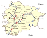
Andorra , officially the Principality of Andorra , also called the Principality of the Valleys of Andorra, , is a small landlocked country in southwestern Europe, located in the eastern Pyrenees mountains and bordered by Spain and France. It is the sixth smallest nation in Europe having an area of...
is a small, landlocked country in southwestern Europe, located in the eastern Pyrenees
Pyrenees
The Pyrenees is a range of mountains in southwest Europe that forms a natural border between France and Spain...
mountain range and bordered by Spain and France. With an area of 468 km², it is the sixth smallest country in Europe and also the largest of the European microstates
European microstates
The European microstates or ministates are a set of very small states in Europe. While Andorra, Liechtenstein, Malta, Monaco, San Marino, and Vatican City are usually included, Luxembourg and Cyprus share certain features as well...
.
Andorra consists predominantly of rugged mountains, the highest being the Coma Pedrosa
Coma Pedrosa
Coma Pedrosa is the highest mountain in the principality of Andorra. It is popular with mountain climbers, its ascent being technically straightforward, although strenuous. Several mountain lakes and tarns are found on the slopes, notably Estanys de Baiau, which lies on the western slopes, across...
at 2942 metres (9,652 ft), and the average elevation of Andorra is 1996 metres (6,549 ft). These are dissected by three narrow valleys in a Y shape that combine into one as the main stream, the Gran Valira river, leaves the country for Spain (at Andorra's lowest point of 840 m (2,756 ft)).
Andorra's climate
Climate
Climate encompasses the statistics of temperature, humidity, atmospheric pressure, wind, rainfall, atmospheric particle count and other meteorological elemental measurements in a given region over long periods...
is similar to that of its neighbours' temperate climates, but its higher elevation means there is, on average, more snow in winter, lower humidity, and it is slightly cooler in summer. There are, on average, 300 days per year of sunshine.
Phytogeographically
Phytogeography
Phytogeography , also called geobotany, is the branch of biogeography that is concerned with the geographic distribution of plant species...
, Andorra belongs to the Atlantic European province of the Circumboreal Region
Circumboreal Region
The Circumboreal Region is a floristic region within the Holarctic Kingdom in Eurasia and North America, as delineated by such geobotanists as Josias Braun-Blanquet and Armen Takhtajan....
within the Boreal Kingdom
Boreal Kingdom
The Boreal Kingdom or Holarctic Kingdom is a floristic kingdom identified by botanist Ronald Good , which includes the temperate to Arctic portions of North America and Eurasia. Its flora is inherited from the ancient supercontinent of Laurasia...
. According to the WWF
World Wide Fund for Nature
The World Wide Fund for Nature is an international non-governmental organization working on issues regarding the conservation, research and restoration of the environment, formerly named the World Wildlife Fund, which remains its official name in Canada and the United States...
, the territory of Andorra belongs to the ecoregion of Pyrenees conifer and mixed forests.
Landslides and avalanches are the main natural hazards. There are frequent earthquakes below Richter magnitude 2. There is no historical record of any damaging earthquakes in Andorra, but the Andorran government has studied the possibility of a future one.
Mountains
All of Andorra is mountainous, and in total, there are 65 mountain peaks.The highest mountain is Coma Pedrosa
Coma Pedrosa
Coma Pedrosa is the highest mountain in the principality of Andorra. It is popular with mountain climbers, its ascent being technically straightforward, although strenuous. Several mountain lakes and tarns are found on the slopes, notably Estanys de Baiau, which lies on the western slopes, across...
, which rises to 2942 m (9,652 ft) in the northwest of Andorra near the French and Spanish borders.
Along the border with France, from west to east, the highest mountains are Pic de Médécourbe
Pic de Médécourbe
Pic de Médécourbe is a mountain in Europe that sits on the western tripoint boundary of Andorra, France and Spain. It is tall. It overlooks Étang de Soulcem, a large artificial lake used for hydroelectricity, and the Vicdessos valley.There is also an eastern tripoint of Andorra, France, and Spain...
(2914 m (9,560 ft)), which is the western tripoint international boundary of Andorra, France, and Spain, Pic de Cataperdis (2805 m (9,203 ft)) and Pic de Tristaina (2878 m (9,442 ft)), Pic de Font Blanca (2903 m (9,524 ft)) in the northwest; Pic de Siguer (2903 m (9,524 ft)), Pic de la Serrera (2914 m (9,560 ft)) and Pic d'Anrodat (2730 m (8,957 ft)) in the north; and Pic de Noé (2737 m (8,980 ft)), Pic de la Cabaneta (2818 m (9,245 ft)) and Roc Mélé (2811 m (9,222 ft)) in the east.
Along the border with Spain, from west to east, the highest mountains are Pic de Médécourbe
Pic de Médécourbe
Pic de Médécourbe is a mountain in Europe that sits on the western tripoint boundary of Andorra, France and Spain. It is tall. It overlooks Étang de Soulcem, a large artificial lake used for hydroelectricity, and the Vicdessos valley.There is also an eastern tripoint of Andorra, France, and Spain...
(2914 m (9,560 ft)), Pic de Coma Pedrosa (2942 m (9,652 ft)), Port de Cabús (2301 m (7,549 ft)) and Pic dels Llacs (2692 m (8,832 ft)) in the west; Pic Negre (2665 m (8,743 ft)), Torre dels Soldats (2761 m (9,058 ft)), and Pic de la Portelleta (2905 m (9,531 ft)) in the south.
In the east, near where the borders of the three countries meet, lies Pic d’Envalira (2825 m (9,268 ft)) and Pic dels Pessons (2865 m (9,400 ft)). A lake, Estany de l'Estanyó, and a mountain, Pic de l’Estanyó (2915 m (9,564 ft)) lie just east of El Serrat
El Serrat
El Serrat is a mountain village in the parish of Ordino, Andorra. It is at an elevation of . It is a popular destination for skiers.-See also:* Flora of Andorra...
and are accessible only by hiking trail.
Lakes and rivers
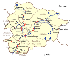
Andorra is drained almost entirely by a single basin whose main river, the Gran Valira, exits the country in the south near the Spain–Andorra road border crossing. There are two main tributaries and six smaller open basins. These basins gave the name by which the region was traditionally known, The Valleys (Les Valls).The Valira del Nord is the northwest tributary, flowing from near El Serrat through the settlements of Les Salines, Arans, La Cortinada, Sornàs, Ordino, and La Massana
La Massana
La Massana is one of the seven parishes of the Principality of Andorra. It is located in the northwest of the country. . La Massana is also the name of the main town of the parish. The name Massana derives from the Latin name mattianam for a variety of apple.The parish is extremely mountainous and...
— where it meets the Tristaina River — and eventually through Les Escaldes
Les Escaldes
Les Escaldes or briefly Escaldes is an urban area in Escaldes-Engordany parish, Andorra. It is located near the nation's capital, Andorra la Vella.-Overview:...
where it meets the Valira d'Orient forming the Gran Valira.
The Valira d'Orient is the northeast tributary, flowing from near Grau Roig
Grau Roig
Grau Roig is a village in Andorra, located in the parish of Encamp. The nearest major settlement is Pas de la Casa, to the east on the border with France....
through Soldeu
Soldeu
-Overview:It comes alive in the winter months as a skiing town. The skiing is on the Grand Valira ski resort, the largest in the Pyrenees with 193 km of runs. According to The Sunday Times, Soldeu is one of the three best budget skiing resorts in Europe. It can be accessed from Encamp,...
, Canillo
Canillo
Canillo is one of the parishes of Andorra. Canillo is also the name of the main town of the parish. Canillo has a gondola link to the main ski resort of Grandvalira.-Geography:...
, Encamp
Encamp
Encamp is one of the parishes of Andorra, located on the Valira d'Orient river, and connected by a cable car to Lake Engolasters. It is also the name of the main town in the parish. Other settlements include Vila, El Pas de la Casa, Grau Roig, el Tremat, la Mosquera, and Les Bons. As of 2004, it...
, and Les Escaldes where it meets the Madriu River and then the Valira del Nord, becoming the Gran Valira.
There are also several much smaller drainage basins that span Andorra's borders with France and Spain. The most notable of these is the Pic de Maià basin whose main river, the Sant Josep, flows easterly out of the country into France and is a tributary of the Ariège River
Ariège River
The Ariège is a 164 km long river in southern France, right tributary of the Garonne. Its source is in the Pyrenees, where it forms part of the border with Andorra...
.
Andorra has 172 lakes, of which the largest is Estanys de Juclar (23 hectares (56.8 acre)) near Pic de Noé in the north east.
Climate
The climate in Andorra varies greatly with elevation. The valleys have a climate that is similar to the temperateTemperate
In geography, temperate or tepid latitudes of the globe lie between the tropics and the polar circles. The changes in these regions between summer and winter are generally relatively moderate, rather than extreme hot or cold...
climate of Andorra's neighbours, but because of the higher elevation, winters tend to be more severe, the humidity lower, and summers slightly cooler. Regions above the Alpine tree line at about 2100 – have an alpine climate
Alpine climate
Alpine climate is the average weather for a region above the tree line. This climate is also referred to as mountain climate or highland climate....
and alpine tundra
Alpine tundra
Alpine tundra is a natural region that does not contain trees because it is at high altitude. Alpine tundra is distinguished from arctic tundra, because alpine soils are generally better drained than arctic soils...
. Snow completely covers the northern valleys for several months. There are, on average, 300 days per year of sunshine. Average daily peak insolation
Insolation
Insolation is a measure of solar radiation energy received on a given surface area in a given time. It is commonly expressed as average irradiance in watts per square meter or kilowatt-hours per square meter per day...
varies from 1150 W
Watt
The watt is a derived unit of power in the International System of Units , named after the Scottish engineer James Watt . The unit, defined as one joule per second, measures the rate of energy conversion.-Definition:...
/m2 in June to 280 W/m2 in December.
The average annual temperature varies from 11 °C (51.8 °F) in Sant Julià de Lòria
Sant Julià de Lòria
Sant Julià de Lòria is one of the parishes of Andorra, in the far south of that country. It is also the name of the main town of the parish, which at 908 m is the lowest settlement in Andorra...
in the south, to 8 °C (46.4 °F) in La Massana
La Massana
La Massana is one of the seven parishes of the Principality of Andorra. It is located in the northwest of the country. . La Massana is also the name of the main town of the parish. The name Massana derives from the Latin name mattianam for a variety of apple.The parish is extremely mountainous and...
in the centre, and to 2 °C (35.6 °F) in Arcalis in the north. The average daily high and low temperatures in Escaldes-Engordany
Escaldes-Engordany
Escaldes-Engordany is one of the parishes of Andorra. The parish is composed of the areas of les Escaldes, Engordany, Els Vilars d'Engordany, Engolasters, and El Fener. As of 2005 it has a population of 16,918. Notable events include the town's annual jazz festival....
are, respectively, 28 °C (82.4 °F) and 15 °C (59 °F) in July, and 11 °C (51.8 °F) and -2 C in January.
Average annual precipitation is 1071.9 mm (42.2 in) for the whole country, but it varies across the country, increasing with elevation and from south to north. The driest parish
Parishes of Andorra
Andorra consists of seven communities known as parishes . Until relatively recently, it had only six parishes; the seventh, Escaldes-Engordany, was created in 1978....
is Sant Julià de Lòria
Sant Julià de Lòria
Sant Julià de Lòria is one of the parishes of Andorra, in the far south of that country. It is also the name of the main town of the parish, which at 908 m is the lowest settlement in Andorra...
(800 mm (31.5 in) per year) in the south, and the wettest is Canillo
Canillo
Canillo is one of the parishes of Andorra. Canillo is also the name of the main town of the parish. Canillo has a gondola link to the main ski resort of Grandvalira.-Geography:...
(1100 mm (43.3 in) per year) in the north. Annual precipitation can exceed 1220 mm (48 in) the highest mountainous areas. The driest months tend to be January and February, and the wettest, May, June, and November. During the summer months, there are very few rainy days, but the rainfall can be very heavy because it is associated with thunderstorms.
Natural resources
Deposits of iron ore, leadLead
Lead is a main-group element in the carbon group with the symbol Pb and atomic number 82. Lead is a soft, malleable poor metal. It is also counted as one of the heavy metals. Metallic lead has a bluish-white color after being freshly cut, but it soon tarnishes to a dull grayish color when exposed...
, alum
Alum
Alum is both a specific chemical compound and a class of chemical compounds. The specific compound is the hydrated potassium aluminium sulfate with the formula KAl2.12H2O. The wider class of compounds known as alums have the related empirical formula, AB2.12H2O.-Chemical properties:Alums are...
, and building stones are among the resources exploited in Andorra, although the economy depends to a much greater extent on tourism
Tourism in Andorra
Andorra has become an important tourist destination in Europe. Andorra has several major ski resorts, including Soldeu/El Tarter and Pal/Arinsal. These are very popular with tourists from Spain, France and the United Kingdom, particularly because their relatively gentle slopes are ideal for less...
. Andorra’s mountainous terrain attracts about 13 million tourists annually, primarily for skiing and hiking. The largest numbers of visitors come from Spain and France – 10,743,201 and 3,723,869 visitors, respectively, in 2007. It is also a popular destination for British tourists, accounting for one in seven of all British package holiday
Package holiday
A package holiday or package tour consists of transport and accommodation advertised and sold together by a vendor known as a tour operator. Other services may be provided like a rental car, activities or outings during the holiday. Transport can be via charter airline to a foreign country...
s — more than for Switzerland, Canada and the US combined.
Avalanches
There is a risk of avalanches from mid winter to early summer. Avalanche controlAvalanche control
Avalanche control or avalanche defense activities reduce the hazard avalanches pose to human life, activity, and property. Avalanche control begins with a risk assessment conducted by surveying for potential avalanche terrain by identifying geographic features such as vegetation patterns,...
methods such as snow clearing by controlled blast charges, snow nets, snow fence
Snow fence
A snow fence is a structure, similar to a sand fence, that forces drifting snow to accumulate in a desired place. They are primarily employed to minimize the amount of snowdrift on roadways and railways. Farmers and ranchers may use temporary snow fences to create large drifts in basins for a...
s, deflectors, rigid barriers, and snow compaction are used in Andorra to prevent dangerous avalanches.
1996 Arinsal avalanche
The 1996 Arinsal avalanche was an exceptionally powerful powder-snow avalanche that followed several days of very heavy snowfalls and high winds. At 19:00 on 8 February 1996, the avalanche fell on the village of ArinsalArinsal
Arinsal is a village in Andorra, set at an altitude of between 1550 and 2560 metres, close to the border with Spain at Tor, Pallars. In the summer Arinsal is home to walkers and bikers, as well as those who just want to relax in the mountain scenery...
destroying or severely damaging many cars and buildings and hotels including the crest hotel the rocky mountain bar and above apartments the asterics bar and little damage to three blocks of flats that were under construction by a Russian company and still are under construction; evacuation of the residents and tourists in the village had been completed 1½ hours before the avalanche, and consequently no lives were lost, but the material and economic damages were large. Afterwards, the government ordered the construction of a snow dam across the Arinsal valley to stop future avalanches. The Arinsal snow dam, which is 16 m (52.5 ft) high and 320 m (1,050 ft) wide, cost 52 million francs
French franc
The franc was a currency of France. Along with the Spanish peseta, it was also a de facto currency used in Andorra . Between 1360 and 1641, it was the name of coins worth 1 livre tournois and it remained in common parlance as a term for this amount of money...
and used 115000 m³ (150,414 cu yd) of soil and 11000 m³ (14,387 cu yd) of rock.
1970 Pas de la Casa avalanche
The 1970 Pas de la Casa avalanche was a powder-snow avalanche that happened after a severe snowstorm left 2 metres (6.6 ft) of new snow atop the existing snow pack on the mountain slopes above Pas de la CasaPas de la Casa
El Pas de la Casa is a ski resort , town, and mountain pass in the Encamp parish of Andorra, lying on the border with France. Its name literally translates as "the pass of the house" and refers to the fact that until the early twentieth century there was only a single shepherd's hut overlooking...
. The avalanche began at an elevation of 2640 m (8,661 ft) on the upper slopes of the Pic d'Envalira (2825 m (9,268 ft)), accelerated down the 35° slope and spilled over six bends of the old CG-2 road that winds its way down the mountain to the village of Pas de la Casa, which is at 2100 m (6,890 ft). It then hit the village, damaging several buildings including a dispensary and killing a nurse. In 1970, Pas de la Casa had far fewer buildings than it does now, so the damage was relatively limited. In later years as development of the ski resort continued, plans for avalanche control measures were studied, but it was not until 1985 that strong protective features including 250 m (820 ft) of windbreaks and 500 m (1,640 ft) of snow fences were installed. The new CG-2 goes through the Envalira Tunnel, thus avoiding Pas de la Casa and the risk of avalanches.
Landslides
Landslides are a frequent occurrence in Andorra; they have tended to follow periods of heavy rainfall.A landslide during the evening rush hour on 25 January 2008 deposited 4000 m³ (5,232 cu yd) of loosely bound soil and rocks from the mountain slope above onto the main road CG-3 (Avinguda del Través de la Massana) between La Massana and Ordino, blocking it for three days, as well as completely covering an open-air car park and several parked cars. The only damage was to property, and nobody was injured, but the residents of a block of flats adjacent to the landslide were evacuated as the building was deemed unsafe and it remains vacant. The cause of the landslide was determined to be settlement of the earth due to inadequate ground reinforcement in the construction and excavation of the car park 30 years previously.
On 7 July 2009, a rock landslide fell 200 m (656 ft) onto the CG-3 main road between La Massana and Andorra La Vella, blocking the road near the entrance to the Pont Pla Tunnel for three hours. Protective nets on the mountain side caught most of the rockfall, but 4 m³ (5.23 cu yd) went over the nets and fell onto the road and pavement.
Earthquakes
The Pyrenees and Catalonia have frequent and sometimes destructive earthquakes — the largest in recorded history being the Catalan earthquake of 1428Catalan earthquake of 1428
The Catalan earthquake of 2 February 1428, known in Catalan as the terratrèmol de la candelera because it took place during the Candlemas, struck the region of Catalonia, especially Roussillon, with an epicentre near Camprodon. The quake was one of a series of related seismic events that shook...
with an estimated magnitude of IX on the MSK
Medvedev-Sponheuer-Karnik scale
The Medvedev-Sponheuer-Karnik scale, also known as the MSK or MSK-64, is a macroseismic intensity scale used to evaluate the severity of ground shaking on the basis of observed effects in an area of the earthquake occurrence....
scale, equivalent to 6.0-6.5 on the Richter scale. However, earthquakes whose epicentres are inside Andorra tend to be smaller than magnitude 2. An earthquake of magnitude 4.2 on 5 October 1999 in nearby Banheras-de-Luishon was widely felt in Andorra, causing public alarm. The Andorran Government has studied the possibility of a damaging earthquake in Andorra.
Extreme points
Latitude and longitude- North : Basers de Font Blanca (42°39′17"N 1°33′4"E)
- South : Conangle - Riu Runer (42°25′43"N 1°31′2"E)
- West : Coll de l'Aquell (42°29′11"N 1°24′32"E)
- East : Riu de la Palomera - Riu Arièja (42°34′26"N 1°47′10"E)
Elevation
- Maximum : Pic del Comapedrosa, 2942 m (9,652.23 ft) (42°35′N 01°27′E)
- Minimum : Conflent del riu Runer, 840 m (2,755.91 ft) (42°26′N 01°29′E)
Centre
- Geographical centreGeographical centreIn geography, the centroid of the two-dimensional shape of region of the Earth's surface is often known as its geographical centre. There has long been debate over the methods of calculation of the geographical centres of various countries and regions, such as whether to include offshore islands,...
: near EncampEncampEncamp is one of the parishes of Andorra, located on the Valira d'Orient river, and connected by a cable car to Lake Engolasters. It is also the name of the main town in the parish. Other settlements include Vila, El Pas de la Casa, Grau Roig, el Tremat, la Mosquera, and Les Bons. As of 2004, it...
, 42°32′30"N 01°35′51"E