
Geography of Alaska
Encyclopedia
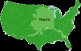
Alaska
is one of two U.S. state
s not bordered by another state; Hawaii
the other. Alaska has more ocean coastline than all of the other U.S. states combined. About 500 miles (804.7 km) of Canadian
territory separate Alaska from Washington State. Alaska is thus an exclave of the United States that is part of the continental U.S. but is not part of the contiguous U.S. Alaska is also the only state whose capital city
is accessible only via ship or air
. No roads connect Juneau to the rest of the continent.
The state is bordered by Yukon
and British Columbia
, Canada
to the east, the Gulf of Alaska
and the Pacific Ocean
to the south, the Bering Sea
, Bering Strait
, and Chukchi Sea
to the west, and the Beaufort Sea
and the Arctic Ocean
to the north.
 Because it extends into the Eastern Hemisphere
, it is technically both the westernmost and easternmost state in the United States, as well as also being the northernmost.
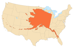
Alaska is the largest state in the United States in terms of land area at 570380 square miles (1,477,277.4 km²), over twice as large as Texas
, the next largest state. If the state's westernmost point were superimposed on San Francisco, California
, its easternmost point would be in Jacksonville, Florida
. It is larger than all but 18 sovereign nations. Alaska is home to 3.5 million lake
s of 20 acres (8.1 ha) or larger. Marshlands and wetland permafrost
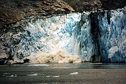
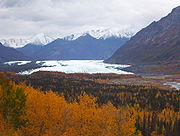
cover 188320 square miles (487,746.6 km²) (mostly in northern, western and southwest flatlands). Frozen water, in the form of glacier
ice, covers some 16000 square miles (41,439.8 km²) of land and 1200 square miles (3,108 km²) of tidal zone. The Bering Glacier
complex near the southeastern border with Yukon
, Canada
, covers 2250 square miles (5,827.5 km²) alone.
The northeast corner of Alaska is covered by the Arctic National Wildlife Refuge
, which covers 19049236 acres (7,708,959 ha). Much of the northwest is covered by the larger National Petroleum Reserve–Alaska
, which covers around 23 million acres (9,307,778 ha). The Arctic is Alaska's most remote wilderness. A location in the National Petroleum Reserve–Alaska
is 120 miles (193.1 km) from any town or village, the geographic point most remote from permanent habitation in the USA.
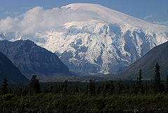
With its numerous islands, Alaska has nearly 34,000 miles (55,000 km) of tidal shoreline. The island chain extending west from the southern tip of the Alaska Peninsula
is called the Aleutian Islands. Many active volcano
es are found in the Aleutians. For example, Unimak Island
is home to Mount Shishaldin
, a moderately active volcano that rises to 9980 feet (3,042 m) above sea level
. The chain of volcanoes extends to Mount Spurr
, west of Anchorage on the mainland.
One of North America's largest tides occurs in Turnagain Arm just south of Anchorage. Tidal differences can be more than 35 feet (10.7 m). (Many sources say Turnagain has the second-greatest tides in North America, but it has since been shown that several areas in Canada have larger tides, according to an Anchorage Daily News
article dated 6/23/03.)
The Aleutian Islands cross longitude 180°, so Alaska can be considered the easternmost state as well as the westernmost. Alaska and, especially, the Aleutians are one of the extreme points of the United States
. The International Date Line
jogs west of 180° to keep the whole state, and thus the entire continental United States, within the same legal day.
as national forest
s, national park
s, and national wildlife refuge
s. Of these, the Bureau of Land Management
manages 87000000 acre, or 23.8% of the state. The Arctic National Wildlife Refuge
is managed by the United States Fish and Wildlife Service
.
Of the remaining land area, the State of Alaska owns 24.5%; another 10% is managed by thirteen regional and dozens of local Native corporations created under the Alaska Native Claims Settlement Act
. Various private interests own the remaining land, totaling less than 1%.
Alaska is administratively divided into "boroughs," as opposed to "counties." The function is the same, but whereas some states use a three-tiered system of decentralization — state/county/township — most of Alaska only uses two tiers — state/borough. Owing to the state's low population density, most of the land is located in the Unorganized Borough
which, as the name implies, has no intermediate borough government of its own, but is administered directly by the state government. Currently (2000 census
) 57.71 percent of Alaska's land area has this status; however, its population comprises only 13.05 percent of the state's total. For statistical purposes the United States Census Bureau
divides this territory into census areas. Anchorage merged the city government with the Greater Anchorage Area Borough in 1971 to form the Municipality of Anchorage, containing the city proper, and the bedroom communities of Eagle River, Chugiak, Peters Creek, Girdwood, Bird, and Indian. Fairbanks, on the other hand, has a separate borough (the Fairbanks North Star Borough) and municipality (the City of Fairbanks)
Alaska
Alaska is the largest state in the United States by area. It is situated in the northwest extremity of the North American continent, with Canada to the east, the Arctic Ocean to the north, and the Pacific Ocean to the west and south, with Russia further west across the Bering Strait...
is one of two U.S. state
U.S. state
A U.S. state is any one of the 50 federated states of the United States of America that share sovereignty with the federal government. Because of this shared sovereignty, an American is a citizen both of the federal entity and of his or her state of domicile. Four states use the official title of...
s not bordered by another state; Hawaii
Hawaii
Hawaii is the newest of the 50 U.S. states , and is the only U.S. state made up entirely of islands. It is the northernmost island group in Polynesia, occupying most of an archipelago in the central Pacific Ocean, southwest of the continental United States, southeast of Japan, and northeast of...
the other. Alaska has more ocean coastline than all of the other U.S. states combined. About 500 miles (804.7 km) of Canadian
Canada
Canada is a North American country consisting of ten provinces and three territories. Located in the northern part of the continent, it extends from the Atlantic Ocean in the east to the Pacific Ocean in the west, and northward into the Arctic Ocean...
territory separate Alaska from Washington State. Alaska is thus an exclave of the United States that is part of the continental U.S. but is not part of the contiguous U.S. Alaska is also the only state whose capital city
Capital City
Capital City was a television show produced by Euston Films which focused on the lives of investment bankers in London living and working on the corporate trading floor for the fictional international bank Shane-Longman....
is accessible only via ship or air
Aviation
Aviation is the design, development, production, operation, and use of aircraft, especially heavier-than-air aircraft. Aviation is derived from avis, the Latin word for bird.-History:...
. No roads connect Juneau to the rest of the continent.
The state is bordered by Yukon
Yukon
Yukon is the westernmost and smallest of Canada's three federal territories. It was named after the Yukon River. The word Yukon means "Great River" in Gwich’in....
and British Columbia
British Columbia
British Columbia is the westernmost of Canada's provinces and is known for its natural beauty, as reflected in its Latin motto, Splendor sine occasu . Its name was chosen by Queen Victoria in 1858...
, Canada
Canada
Canada is a North American country consisting of ten provinces and three territories. Located in the northern part of the continent, it extends from the Atlantic Ocean in the east to the Pacific Ocean in the west, and northward into the Arctic Ocean...
to the east, the Gulf of Alaska
Gulf of Alaska
The Gulf of Alaska is an arm of the Pacific Ocean defined by the curve of the southern coast of Alaska, stretching from the Alaska Peninsula and Kodiak Island in the west to the Alexander Archipelago in the east, where Glacier Bay and the Inside Passage are found.The entire shoreline of the Gulf is...
and the Pacific Ocean
Pacific Ocean
The Pacific Ocean is the largest of the Earth's oceanic divisions. It extends from the Arctic in the north to the Southern Ocean in the south, bounded by Asia and Australia in the west, and the Americas in the east.At 165.2 million square kilometres in area, this largest division of the World...
to the south, the Bering Sea
Bering Sea
The Bering Sea is a marginal sea of the Pacific Ocean. It comprises a deep water basin, which then rises through a narrow slope into the shallower water above the continental shelves....
, Bering Strait
Bering Strait
The Bering Strait , known to natives as Imakpik, is a sea strait between Cape Dezhnev, Chukotka Autonomous Okrug, Russia, the easternmost point of the Asian continent and Cape Prince of Wales, Alaska, USA, the westernmost point of the North American continent, with latitude of about 65°40'N,...
, and Chukchi Sea
Chukchi Sea
Chukchi Sea is a marginal sea of the Arctic Ocean. It is bounded on the west by the De Long Strait, off Wrangel Island, and in the east by Point Barrow, Alaska, beyond which lies the Beaufort Sea. The Bering Strait forms its southernmost limit and connects it to the Bering Sea and the Pacific...
to the west, and the Beaufort Sea
Beaufort Sea
The Beaufort Sea is a marginal sea of the Arctic Ocean, located north of the Northwest Territories, the Yukon, and Alaska, west of Canada's Arctic islands. The sea is named after hydrographer Sir Francis Beaufort...
and the Arctic Ocean
Arctic Ocean
The Arctic Ocean, located in the Northern Hemisphere and mostly in the Arctic north polar region, is the smallest and shallowest of the world's five major oceanic divisions...
to the north.
Eastern Hemisphere
The Eastern Hemisphere, also Eastern hemisphere or eastern hemisphere, is a geographical term for the half of the Earth that is east of the Prime Meridian and west of 180° longitude. It is also used to refer to Europe, Asia, Africa, and Australasia, vis-à-vis the Western Hemisphere, which includes...
, it is technically both the westernmost and easternmost state in the United States, as well as also being the northernmost.
Alaska is the largest state in the United States in terms of land area at 570380 square miles (1,477,277.4 km²), over twice as large as Texas
Texas
Texas is the second largest U.S. state by both area and population, and the largest state by area in the contiguous United States.The name, based on the Caddo word "Tejas" meaning "friends" or "allies", was applied by the Spanish to the Caddo themselves and to the region of their settlement in...
, the next largest state. If the state's westernmost point were superimposed on San Francisco, California
San Francisco, California
San Francisco , officially the City and County of San Francisco, is the financial, cultural, and transportation center of the San Francisco Bay Area, a region of 7.15 million people which includes San Jose and Oakland...
, its easternmost point would be in Jacksonville, Florida
Jacksonville, Florida
Jacksonville is the largest city in the U.S. state of Florida in terms of both population and land area, and the largest city by area in the contiguous United States. It is the county seat of Duval County, with which the city government consolidated in 1968...
. It is larger than all but 18 sovereign nations. Alaska is home to 3.5 million lake
Lake
A lake is a body of relatively still fresh or salt water of considerable size, localized in a basin, that is surrounded by land. Lakes are inland and not part of the ocean and therefore are distinct from lagoons, and are larger and deeper than ponds. Lakes can be contrasted with rivers or streams,...
s of 20 acres (8.1 ha) or larger. Marshlands and wetland permafrost
Permafrost
In geology, permafrost, cryotic soil or permafrost soil is soil at or below the freezing point of water for two or more years. Ice is not always present, as may be in the case of nonporous bedrock, but it frequently occurs and it may be in amounts exceeding the potential hydraulic saturation of...
cover 188320 square miles (487,746.6 km²) (mostly in northern, western and southwest flatlands). Frozen water, in the form of glacier
Glacier
A glacier is a large persistent body of ice that forms where the accumulation of snow exceeds its ablation over many years, often centuries. At least 0.1 km² in area and 50 m thick, but often much larger, a glacier slowly deforms and flows due to stresses induced by its weight...
ice, covers some 16000 square miles (41,439.8 km²) of land and 1200 square miles (3,108 km²) of tidal zone. The Bering Glacier
Bering Glacier
Bering Glacier is a glacier in the U.S. state of Alaska. It currently terminates in Vitus Lake south of Alaska’s Wrangell-St. Elias National Park, about from the Gulf of Alaska. Combined with the Bagley Icefield, where the snow that feeds the glacier accumulates, the Bering is the largest glacier...
complex near the southeastern border with Yukon
Yukon
Yukon is the westernmost and smallest of Canada's three federal territories. It was named after the Yukon River. The word Yukon means "Great River" in Gwich’in....
, Canada
Canada
Canada is a North American country consisting of ten provinces and three territories. Located in the northern part of the continent, it extends from the Atlantic Ocean in the east to the Pacific Ocean in the west, and northward into the Arctic Ocean...
, covers 2250 square miles (5,827.5 km²) alone.
Regions
- South Central AlaskaSouth Central AlaskaSouthcentral Alaska is the portion of the U.S. state of Alaska consisting of the shorelines and uplands of the central Gulf of Alaska. Most of the population of the state lives in this region, concentrated in and around the city of Anchorage....
is the southern coastal region and contains most of the state's population. AnchorageAnchorage, AlaskaAnchorage is a unified home rule municipality in the southcentral part of the U.S. state of Alaska. It is the northernmost major city in the United States...
and many growing towns, such as PalmerPalmer, AlaskaPalmer is the borough seat of the Matanuska-Susitna Borough in the state of Alaska, USA. It is part of the Anchorage Metropolitan Statistical Area. As of the 2010 census, the population of the city is 5,937....
, and WasillaWasilla, AlaskaWasilla is a city in Matanuska-Susitna Borough, United States and the sixth-largest city in Alaska. It is located on the northern point of Cook Inlet in the Matanuska-Susitna Valley of the southcentral part of the state. The city's population was 7,831 at the 2010 census...
, lie within this area. PetroleumPetroleumPetroleum or crude oil is a naturally occurring, flammable liquid consisting of a complex mixture of hydrocarbons of various molecular weights and other liquid organic compounds, that are found in geologic formations beneath the Earth's surface. Petroleum is recovered mostly through oil drilling...
industrial plants, transportation, tourismTourismTourism is travel for recreational, leisure or business purposes. The World Tourism Organization defines tourists as people "traveling to and staying in places outside their usual environment for not more than one consecutive year for leisure, business and other purposes".Tourism has become a...
, and two military baseMilitary baseA military base is a facility directly owned and operated by or for the military or one of its branches that shelters military equipment and personnel, and facilitates training and operations. In general, a military base provides accommodations for one or more units, but it may also be used as a...
s form the core of the economy here. - The Alaska PanhandleAlaska PanhandleSoutheast Alaska, sometimes referred to as the Alaska Panhandle, is the southeastern portion of the U.S. state of Alaska, which lies west of the northern half of the Canadian province of British Columbia. The majority of Southeast Alaska's area is part of the Tongass National Forest, the United...
, also known as Southeast Alaska, is home to many of Alaska's larger towns including the state capital Juneau, tidewater glacierGlacierA glacier is a large persistent body of ice that forms where the accumulation of snow exceeds its ablation over many years, often centuries. At least 0.1 km² in area and 50 m thick, but often much larger, a glacier slowly deforms and flows due to stresses induced by its weight...
s and extensive forests. Tourism, fishing, forestry and state government anchor the economy. - Southwest AlaskaSouthwest AlaskaSouthwest Alaska is a region of the U.S. state of Alaska. The area is not exactly defined by any governmental administrative region; nor does it always have a clear geographic boundary.-Geography:...
is largely coastal, bordered by both the Pacific OceanPacific OceanThe Pacific Ocean is the largest of the Earth's oceanic divisions. It extends from the Arctic in the north to the Southern Ocean in the south, bounded by Asia and Australia in the west, and the Americas in the east.At 165.2 million square kilometres in area, this largest division of the World...
and the Bering SeaBering SeaThe Bering Sea is a marginal sea of the Pacific Ocean. It comprises a deep water basin, which then rises through a narrow slope into the shallower water above the continental shelves....
. It is sparsely populated, and unconnected to the road system, but incredibly important to the fishing industry. Half of all fish caught in the western U.S. come from the Bering SeaBering SeaThe Bering Sea is a marginal sea of the Pacific Ocean. It comprises a deep water basin, which then rises through a narrow slope into the shallower water above the continental shelves....
, and Bristol BayBristol BayBristol Bay is the eastern-most arm of the Bering Sea, at 57° to 59° North 157° to 162° West in Southwest Alaska. Bristol Bay is 400 km long and 290 km, wide at its mouth...
has the world's largest sockeye salmonSockeye salmonSockeye salmon , also called red salmon or blueback salmon in the USA, is an anadromous species of salmon found in the Northern Pacific Ocean and rivers discharging into it...
fishery. Southwest AlaskaSouthwest AlaskaSouthwest Alaska is a region of the U.S. state of Alaska. The area is not exactly defined by any governmental administrative region; nor does it always have a clear geographic boundary.-Geography:...
includes KatmaiKatmai National Park and PreserveKatmai National Park and Preserve is a United States National Park in southern Alaska, notable for the Valley of Ten Thousand Smokes and for its brown bears. The park covers , being roughly the size of Wales. Most of this is a designated wilderness area, including of the park...
and Lake Clark national parks as well as numerous wildlife refuges. The region comprises western Cook InletCook InletCook Inlet stretches from the Gulf of Alaska to Anchorage in south-central Alaska. Cook Inlet branches into the Knik Arm and Turnagain Arm at its northern end, almost surrounding Anchorage....
, Bristol BayBristol BayBristol Bay is the eastern-most arm of the Bering Sea, at 57° to 59° North 157° to 162° West in Southwest Alaska. Bristol Bay is 400 km long and 290 km, wide at its mouth...
and its watersheds, the Alaska PeninsulaAlaska PeninsulaThe Alaska Peninsula is a peninsula extending about to the southwest from the mainland of Alaska and ending in the Aleutian Islands. The peninsula separates the Pacific Ocean from Bristol Bay, an arm of the Bering Sea....
and the Aleutian Islands. It is known for wet and stormy weather, tundra landscapes, and large populations of salmonSalmonSalmon is the common name for several species of fish in the family Salmonidae. Several other fish in the same family are called trout; the difference is often said to be that salmon migrate and trout are resident, but this distinction does not strictly hold true...
, brown bearsBrown BearsThe Brown Bears is a name shared by all sports teams at Brown University, a university located in Providence, Rhode Island in the United States. The Bears are part of the Ivy League conference. Brown's mascot is Bruno. Both the men's and women's teams share the name, competing in 37 National...
, caribou, birds, and marine mammals. - The Alaska InteriorAlaska InteriorThe Alaska Interior covers most of the U.S. state's territory. It is largely wilderness. Mountains include Mount McKinley in the Alaska Range, the Wrangell Mountains, and the Ray Mountains....
is home to FairbanksFairbanks, AlaskaFairbanks is a home rule city in and the borough seat of the Fairbanks North Star Borough in the U.S. state of Alaska.Fairbanks is the largest city in the Interior region of Alaska, and second largest in the state behind Anchorage...
. The geography is marked by large braided riverBraided riverA braided river is one of a number of channel types and has a channel that consists of a network of small channels separated by small and often temporary islands called braid bars or, in British usage, aits or eyots. Braided streams occur in rivers with high slope and/or large sediment load...
s, such as the Yukon RiverYukon RiverThe Yukon River is a major watercourse of northwestern North America. The source of the river is located in British Columbia, Canada. The next portion lies in, and gives its name to Yukon Territory. The lower half of the river lies in the U.S. state of Alaska. The river is long and empties into...
and the Kuskokwim RiverKuskokwim RiverThe Kuskokwim River or Kusko River is a river, long, in Southwest Alaska in the United States. It is the ninth largest river in the United States by average discharge volume at its mouth and seventeenth largest by basin drainage area.The river provides the principal drainage for an area of the...
, as well as ArcticArcticThe Arctic is a region located at the northern-most part of the Earth. The Arctic consists of the Arctic Ocean and parts of Canada, Russia, Greenland, the United States, Norway, Sweden, Finland, and Iceland. The Arctic region consists of a vast, ice-covered ocean, surrounded by treeless permafrost...
tundraTundraIn physical geography, tundra is a biome where the tree growth is hindered by low temperatures and short growing seasons. The term tundra comes through Russian тундра from the Kildin Sami word tūndâr "uplands," "treeless mountain tract." There are three types of tundra: Arctic tundra, alpine...
lands and shorelines. - The Alaskan Bush is the remote, less crowded part of the state, encompassing 380 native villages and small towns such as NomeNome, AlaskaNome is a city in the Nome Census Area in the Unorganized Borough of the U.S. state of Alaska, located on the southern Seward Peninsula coast on Norton Sound of the Bering Sea. According to the 2010 Census, the city population was 3,598. Nome was incorporated on April 9, 1901, and was once the...
, BethelBethel, AlaskaBethel is a city located near the west coast of the U.S. state of Alaska, west of Anchorage. Accessible only by air and river, Bethel is the main port on the Kuskokwim River and is an administrative and transportation hub for the 56 villages in the Yukon-Kuskokwim Delta.Bethel is the largest...
, KotzebueKotzebue, AlaskaAs of the census of 2000, there were 3,082 people, 889 households, and 656 families residing in the city. The population density was 114.1 people per square mile . There were 1,007 housing units at an average density of 37.3 per square mile...
and, most famously, BarrowBarrow, AlaskaBarrow is the largest city of the North Slope Borough in the U.S. state of Alaska. It is one of the northernmost cities in the world and is the northernmost city in the United States of America, with nearby Point Barrow being the nation's northernmost point. Barrow's population was 4,212 at the...
, the northernmost town in the United States.
The northeast corner of Alaska is covered by the Arctic National Wildlife Refuge
Arctic National Wildlife Refuge
The Arctic National Wildlife Refuge is a national wildlife refuge in northeastern Alaska, United States. It consists of in the Alaska North Slope region. It is the largest National Wildlife Refuge in the country, slightly larger than the Yukon Delta National Wildlife Refuge...
, which covers 19049236 acres (7,708,959 ha). Much of the northwest is covered by the larger National Petroleum Reserve–Alaska
National Petroleum Reserve–Alaska
The National Petroleum Reserve in Alaska is an area of land on the Alaska North Slope owned by the United States federal government and managed by the Department of the Interior, Bureau of Land Management . It lies to the west of the Arctic National Wildlife Refuge, which as a U.S...
, which covers around 23 million acres (9,307,778 ha). The Arctic is Alaska's most remote wilderness. A location in the National Petroleum Reserve–Alaska
National Petroleum Reserve–Alaska
The National Petroleum Reserve in Alaska is an area of land on the Alaska North Slope owned by the United States federal government and managed by the Department of the Interior, Bureau of Land Management . It lies to the west of the Arctic National Wildlife Refuge, which as a U.S...
is 120 miles (193.1 km) from any town or village, the geographic point most remote from permanent habitation in the USA.
With its numerous islands, Alaska has nearly 34,000 miles (55,000 km) of tidal shoreline. The island chain extending west from the southern tip of the Alaska Peninsula
Alaska Peninsula
The Alaska Peninsula is a peninsula extending about to the southwest from the mainland of Alaska and ending in the Aleutian Islands. The peninsula separates the Pacific Ocean from Bristol Bay, an arm of the Bering Sea....
is called the Aleutian Islands. Many active volcano
Volcano
2. Bedrock3. Conduit 4. Base5. Sill6. Dike7. Layers of ash emitted by the volcano8. Flank| 9. Layers of lava emitted by the volcano10. Throat11. Parasitic cone12. Lava flow13. Vent14. Crater15...
es are found in the Aleutians. For example, Unimak Island
Unimak Island
Unimak Island is the largest island in the Aleutian Islands chain of the U.S. state of Alaska. It is the easternmost island in the Aleutians and, with an area of 1,571.41 mi² , the ninth largest island in the United States and the 134th largest island in the world. It is home to Mount...
is home to Mount Shishaldin
Mount Shishaldin
Mount Shishaldin is a moderately active volcano on Unimak Island in the Aleutian Islands chain of Alaska. It is the tallest mountain in the Aleutian Islands. The most symmetrical cone-shaped glacier-clad large mountain on earth, the volcano's topographic contour lines are nearly perfect circles...
, a moderately active volcano that rises to 9980 feet (3,042 m) above sea level
Sea level
Mean sea level is a measure of the average height of the ocean's surface ; used as a standard in reckoning land elevation...
. The chain of volcanoes extends to Mount Spurr
Mount Spurr
Mount Spurr is a stratovolcano in the Aleutian Volcanic Arc of Alaska, named after United States Geological Survey geologist and explorer Josiah Edward Spurr, who led an expedition to the area in 1898...
, west of Anchorage on the mainland.
One of North America's largest tides occurs in Turnagain Arm just south of Anchorage. Tidal differences can be more than 35 feet (10.7 m). (Many sources say Turnagain has the second-greatest tides in North America, but it has since been shown that several areas in Canada have larger tides, according to an Anchorage Daily News
Anchorage Daily News
The Anchorage Daily News is a daily newspaper based in Anchorage, Alaska, in the United States. It is often referred to colloquially as either "the Daily News" or "the ADN"...
article dated 6/23/03.)
The Aleutian Islands cross longitude 180°, so Alaska can be considered the easternmost state as well as the westernmost. Alaska and, especially, the Aleutians are one of the extreme points of the United States
Extreme points of the United States
This is a list of the extreme points of the United States, the points that are farther north, south, east, or west than any other location in the country. Also included are extreme points in elevation, extreme distances, and other points of peculiar geographic interest.-Northernmost:*Point Barrow,...
. The International Date Line
International Date Line
The International Date Line is a generally north-south imaginary line on the surface of the Earth, passing through the middle of the Pacific Ocean, that designates the place where each calendar day begins...
jogs west of 180° to keep the whole state, and thus the entire continental United States, within the same legal day.
Land Management
According to an October 1998 report by the United States Bureau of Land Management, approximately 65% of Alaska is owned and managed by the U.S. federal governmentFederal government of the United States
The federal government of the United States is the national government of the constitutional republic of fifty states that is the United States of America. The federal government comprises three distinct branches of government: a legislative, an executive and a judiciary. These branches and...
as national forest
United States National Forest
National Forest is a classification of federal lands in the United States.National Forests are largely forest and woodland areas owned by the federal government and managed by the United States Forest Service, part of the United States Department of Agriculture. Land management of these areas...
s, national park
National park
A national park is a reserve of natural, semi-natural, or developed land that a sovereign state declares or owns. Although individual nations designate their own national parks differently A national park is a reserve of natural, semi-natural, or developed land that a sovereign state declares or...
s, and national wildlife refuge
National Wildlife Refuge
National Wildlife Refuge is a designation for certain protected areas of the United States managed by the United States Fish and Wildlife Service. The National Wildlife Refuge System is the world's premiere system of public lands and waters set aside to conserve America's fish, wildlife and plants...
s. Of these, the Bureau of Land Management
Bureau of Land Management
The Bureau of Land Management is an agency within the United States Department of the Interior which administers America's public lands, totaling approximately , or one-eighth of the landmass of the country. The BLM also manages of subsurface mineral estate underlying federal, state and private...
manages 87000000 acre, or 23.8% of the state. The Arctic National Wildlife Refuge
Arctic National Wildlife Refuge
The Arctic National Wildlife Refuge is a national wildlife refuge in northeastern Alaska, United States. It consists of in the Alaska North Slope region. It is the largest National Wildlife Refuge in the country, slightly larger than the Yukon Delta National Wildlife Refuge...
is managed by the United States Fish and Wildlife Service
United States Fish and Wildlife Service
The United States Fish and Wildlife Service is a federal government agency within the United States Department of the Interior dedicated to the management of fish, wildlife, and natural habitats...
.
Of the remaining land area, the State of Alaska owns 24.5%; another 10% is managed by thirteen regional and dozens of local Native corporations created under the Alaska Native Claims Settlement Act
Alaska Native Claims Settlement Act
The Alaska Native Claims Settlement Act, commonly abbreviated ANCSA, was signed into law by President Richard M. Nixon on December 23, 1971, the largest land claims settlement in United States history. ANCSA was intended to resolve the long-standing issues surrounding aboriginal land claims in...
. Various private interests own the remaining land, totaling less than 1%.
Alaska is administratively divided into "boroughs," as opposed to "counties." The function is the same, but whereas some states use a three-tiered system of decentralization — state/county/township — most of Alaska only uses two tiers — state/borough. Owing to the state's low population density, most of the land is located in the Unorganized Borough
Unorganized Borough
The Unorganized Borough is the part of the U.S. state of Alaska not contained in any of its 18 organized boroughs. It encompasses more than half of Alaska's area, , an area larger than any other US state...
which, as the name implies, has no intermediate borough government of its own, but is administered directly by the state government. Currently (2000 census
United States Census, 2000
The Twenty-second United States Census, known as Census 2000 and conducted by the Census Bureau, determined the resident population of the United States on April 1, 2000, to be 281,421,906, an increase of 13.2% over the 248,709,873 persons enumerated during the 1990 Census...
) 57.71 percent of Alaska's land area has this status; however, its population comprises only 13.05 percent of the state's total. For statistical purposes the United States Census Bureau
United States Census Bureau
The United States Census Bureau is the government agency that is responsible for the United States Census. It also gathers other national demographic and economic data...
divides this territory into census areas. Anchorage merged the city government with the Greater Anchorage Area Borough in 1971 to form the Municipality of Anchorage, containing the city proper, and the bedroom communities of Eagle River, Chugiak, Peters Creek, Girdwood, Bird, and Indian. Fairbanks, on the other hand, has a separate borough (the Fairbanks North Star Borough) and municipality (the City of Fairbanks)
See also
- Alaska census statistical areasAlaska census statistical areasThe United States Census Bureau has defined two Metropolitan Statistical Areas and three Micropolitan Statistical Areas for the State of Alaska. The following table describes these areas with the following information:...
- Alaska PeninsulaAlaska PeninsulaThe Alaska Peninsula is a peninsula extending about to the southwest from the mainland of Alaska and ending in the Aleutian Islands. The peninsula separates the Pacific Ocean from Bristol Bay, an arm of the Bering Sea....
- Bristol BayBristol BayBristol Bay is the eastern-most arm of the Bering Sea, at 57° to 59° North 157° to 162° West in Southwest Alaska. Bristol Bay is 400 km long and 290 km, wide at its mouth...
- List of Alaska National Parks
- List of Alaska rivers
- List of boroughs and census areas in Alaska
- Mountain peaks of AlaskaMountain peaks of AlaskaThis article comprises three sortable tables of mountain peaks of the U.S. State of Alaska.Topographic elevation is the vertical distance above the reference geoid, a precise mathematical model of the Earth's sea level as an equipotential gravitational surface. Topographic prominence is the...