Geographic Information Science
Encyclopedia

Geographic Information System
A geographic information system, geographical information science, or geospatial information studies is a system designed to capture, store, manipulate, analyze, manage, and present all types of geographically referenced data...
(GIS). It is concerned with people, hardware, software
GIS software
The umbrella term GIS software refers to a geographic information system application, which is software used to create, manage, analyze and display geospatial data on digital maps...
, and geospatial
Geospatial
Geospatial analysis is an approach to applying statistical analysis and other informational techniques to geographically based data. Such analysis employs spatial software and analytical methods with terrestrial or geographic datasets, including geographic information systems and...
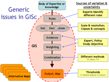
data. GISc addresses fundamental issues raised by the use of GIS and related information technologies (Goodchild 1990, 1992; Wilson and Fotheringham 2007).
See also
General topics- Representation theoryRepresentation theoryRepresentation theory is a branch of mathematics that studies abstract algebraic structures by representing their elements as linear transformations of vector spaces, and studiesmodules over these abstract algebraic structures...
- Geographic information systemGeographic Information SystemA geographic information system, geographical information science, or geospatial information studies is a system designed to capture, store, manipulate, analyze, manage, and present all types of geographically referenced data...
- Spatial analysisSpatial analysisSpatial analysis or spatial statistics includes any of the formal techniques which study entities using their topological, geometric, or geographic properties...
- Spatial autocorrelation
- Complete spatial randomnessComplete spatial randomnessComplete spatial randomness describes a point process whereby point events occur within a given study area in a completely random fashion. Such a process is often modeled using only one parameter, i.e. the density of points, \rho within the defined area...
- Modifiable Areal Unit ProblemModifiable Areal Unit ProblemThe modifiable areal unit problem is a source of statistical bias that can radically affect the results of statistical hypothesis tests. It affects results when point-based measures of spatial phenomena are aggregated into districts. The resulting summary values are influenced by the choice of...
- CartographyCartographyCartography is the study and practice of making maps. Combining science, aesthetics, and technique, cartography builds on the premise that reality can be modeled in ways that communicate spatial information effectively.The fundamental problems of traditional cartography are to:*Set the map's...
- GeovisualizationGeovisualizationGeovisualization, short for Geographic Visualization, refers to a set of tools and techniques supporting geospatial data analysis through the use of interactive visualization....
- Spatial Decision Support SystemSpatial Decision Support SystemSpatial decision support systems developed in parallel with the concept of decision support systems .An sDSS is an interactive, computer-based system designed to support a user or group of users in achieving a higher effectiveness of decision making while solving a semi-structured spatial problem...
s - Cellular automatonCellular automatonA cellular automaton is a discrete model studied in computability theory, mathematics, physics, complexity science, theoretical biology and microstructure modeling. It consists of a regular grid of cells, each in one of a finite number of states, such as "On" and "Off"...
- StewardshipStewardshipStewardship is an ethic that embodies responsible planning and management of resources. The concept of stewardship has been applied in diverse realms, including with respect to environment, economics, health, property, information, and religion, and is linked to the concept of sustainability...
: Geospatial intelligence
External links
- International Cartographic Association (ICA), the world body for mapping and GIScience professionals
- The ESRI Guide to GIS Analysis
- The GIS&T Body of Knowledge
- The University Consortium for Geographic Information Science
- Collection of open source GIS applications

