

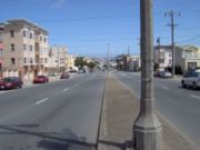
Geary Boulevard
Encyclopedia
San Francisco, California
San Francisco , officially the City and County of San Francisco, is the financial, cultural, and transportation center of the San Francisco Bay Area, a region of 7.15 million people which includes San Jose and Oakland...
, beginning downtown at Market Street
Market Street (San Francisco)
Market Street is an important thoroughfare in San Francisco, California. It begins at The Embarcadero in front of the Ferry Building at the northeastern edge of the city and runs southwest through downtown, passing the Civic Center and the Castro District, to the intersection with Corbett Avenue in...
near Market Street's intersection with Montgomery Street
Montgomery Street
Montgomery Street is a north-south thoroughfare in San Francisco, California, in the United States.It runs about 16 blocks from the Telegraph Hill neighborhood south through downtown, terminating at Market Street. South of Columbus Avenue, Montgomery Street runs through the heart of San Francisco's...
, and running westbound through downtown, the Civic Center area, the Western Addition, and running for most of its length through the predominantly residential Richmond District
Richmond District, San Francisco, California
The Richmond District is a neighborhood in the northwest corner of San Francisco, California.-Location:Lying directly north of Golden Gate Park, "the Richmond" is bounded roughly by Fulton Street to the south, Arguello Boulevard and Laurel Heights to the east, The Presidio National Park and Lincoln...
. Geary Boulevard terminates near Sutro Heights Park at 48th Avenue, close to the Cliff House
Cliff House, San Francisco
The Cliff House is a restaurant perched on the headlands on the cliffs just north of Ocean Beach on the western side of San Francisco, California...
above Ocean Beach at the Pacific Ocean
Pacific Ocean
The Pacific Ocean is the largest of the Earth's oceanic divisions. It extends from the Arctic in the north to the Southern Ocean in the south, bounded by Asia and Australia in the west, and the Americas in the east.At 165.2 million square kilometres in area, this largest division of the World...
. At 40th Avenue, Geary intersects with Point Lobos Avenue, which takes through traffic to the Cliff House, Ocean Beach and the Great Highway
Great Highway
The Great Highway is a road in San Francisco that forms the city's western edge along the Pacific coast. It runs for approximately next to Ocean Beach...
. It is a major commercial artery through the Richmond District; it is lined with stores and restaurants, many of them catering to the various immigrant groups (Chinese, Russian, and Irish, among many others) who live in the area. The boulevard borders Japantown between Fillmore and Laguna Streets.
Geary Boulevard carries two-way traffic for most of its route, but the segment east of Gough Street carries only westbound traffic; at Gough, eastbound traffic is diverted by a short curved street, Starr King Way, onto O'Farrell Street, which runs parallel to Geary until it reaches Market Street.
The roadway is named for John W. Geary
John W. Geary
John White Geary was an American lawyer, politician, Freemason, and a Union general in the American Civil War...
, the first mayor
Mayor
In many countries, a Mayor is the highest ranking officer in the municipal government of a town or a large urban city....
of San Francisco after California became a U.S. state. (Later, he also had the unique distinction of serving as governor of both Kansas
Kansas
Kansas is a US state located in the Midwestern United States. It is named after the Kansas River which flows through it, which in turn was named after the Kansa Native American tribe, which inhabited the area. The tribe's name is often said to mean "people of the wind" or "people of the south...
and Pennsylvania
Pennsylvania
The Commonwealth of Pennsylvania is a U.S. state that is located in the Northeastern and Mid-Atlantic regions of the United States. The state borders Delaware and Maryland to the south, West Virginia to the southwest, Ohio to the west, New York and Ontario, Canada, to the north, and New Jersey to...
.) It began life as a dirt carriage track out to the Cliff House
Cliff House, San Francisco
The Cliff House is a restaurant perched on the headlands on the cliffs just north of Ocean Beach on the western side of San Francisco, California...
and Ocean Beach
Ocean Beach, San Francisco, California
Ocean Beach is a beach that runs along the west coast of San Francisco, California, United States, at the Pacific Ocean. It is adjacent to Golden Gate Park, the Richmond District and the Sunset District. The Great Highway runs alongside the beach, and Cliff House and the site of the former Sutro...
and for a time a flat track paralleled the road where horsemen raced their mounts on Sundays.
Muni
San Francisco Municipal Railway
The San Francisco Municipal Railway is the public transit system for the city and county of San Francisco, California. In 2006, it served with an operating budget of about $700 million...
bus service along Geary Boulevard is provided by the 38 Geary bus line, which is the most heavily used bus line in the city with over 50,000 passengers per day, and over 100,000 passengers per day in adjacent lines (1 California, 2 Clement, 31 Balboa).
There have been feasibility studies by Muni
Muni
"Muni" is a common abbreviation for "municipal" or a city-related service or organization:*The Muny, an outdoor musical theatre in St. Louis, Missouri*Municipal bond*San Francisco Municipal Railway, the public transit agency for San Francisco, California...
that have investigaged the possibility of creating a light rail
Light rail
Light rail or light rail transit is a form of urban rail public transportation that generally has a lower capacity and lower speed than heavy rail and metro systems, but higher capacity and higher speed than traditional street-running tram systems...
line on Geary, but no plans have been adopted yet. A bus rapid transit
Bus rapid transit
Bus rapid transit is a term applied to a variety of public transportation systems using buses to provide faster, more efficient service than an ordinary bus line. Often this is achieved by making improvements to existing infrastructure, vehicles and scheduling...
line is being planned on Geary Boulevard between Van Ness and 33rd Avenue. The target completion date is in 2010-2011. This bus rapid transit corridor will have dedicated bus lanes down Geary Boulevard. The dedicated lanes are planned to be "rail ready," which means the corridor will be designed so as not to preclude future conversion to a streetcar line, including a subway
Rapid transit
A rapid transit, underground, subway, elevated railway, metro or metropolitan railway system is an electric passenger railway in an urban area with a high capacity and frequency, and grade separation from other traffic. Rapid transit systems are typically located either in underground tunnels or on...
section in downtown.
This would not be the first streetcar line on Geary. From 1912, when the San Francisco Municipal Railway
San Francisco Municipal Railway
The San Francisco Municipal Railway is the public transit system for the city and county of San Francisco, California. In 2006, it served with an operating budget of about $700 million...
began service, until 1956, when redevelopment
Redevelopment
Redevelopment is any new construction on a site that has pre-existing uses.-Description:Variations on redevelopment include:* Urban infill on vacant parcels that have no existing activity but were previously developed, especially on Brownfield land, such as the redevelopment of an industrial site...
projects led by Justin Herman included its removal and replacement with buses, the B Geary line ran along this street to Playland
Playland (San Francisco)
Playland was a seaside amusement park located next to Ocean Beach at the western edge of San Francisco, California along the Great Highway where Cabrillo and Balboa streets are now...
and Ocean Beach
Ocean Beach, San Francisco, California
Ocean Beach is a beach that runs along the west coast of San Francisco, California, United States, at the Pacific Ocean. It is adjacent to Golden Gate Park, the Richmond District and the Sunset District. The Great Highway runs alongside the beach, and Cliff House and the site of the former Sutro...
. If and when a future streetcar line is built along Geary, it will once again use the "B" letter.
The section of the boulevard between Franklin Street and Masonic Avenue was upgraded to a signalized expressway
Limited-access road
A limited-access road known by various terms worldwide, including limited-access highway, dual-carriageway and expressway, is a highway or arterial road for high-speed traffic which has many or most characteristics of a controlled-access highway , including limited or no access to adjacent...
in the 1960s. It features between four and eight through lanes and two grade separations at Masonic and Fillmore, complete with semi-exits.
Geary Boulevard also has the highest address and block numbers in San Francisco, with the last block being the 8300 block. In addition, although it is not signed, the city's GIS database records the underpass of Masonic Avenue as the 8400 block.