
Garfield Ridge, Chicago
Encyclopedia
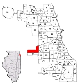
Garfield Ridge is one of the 77 official community areas
of Chicago, Illinois, and is located on the southwest side of the city. The northern half of Chicago Midway International Airport is located in this community area.
. It is served by the CTA's Orange Line
. Garfield Ridge stretches from Pershing Road, just north of the Stevenson Expressway
(Interstate 55
), to 59th Street from north to south, and from the railroad 1/4 mile east of Cicero Avenue to Harlem Avenue going west, with Archer Avenue as its main artery. Bordering communities include South Lawndale
, Archer Heights
and West Elsdon
to the east and Clearing
to the south. To the north are the municipalities of Forest View
, Stickney
and Cicero
, as well as the unincorporated community of Central Stickney, which is located in the "elbow" of Garfield Ridge. To the west is the village of Summit
.
The area of Garfield Ridge has always been in an important geographical section of the Chicago area. It contained the southernmost portion of Mud Lake, a swamp which connected the Chicago and Des Plaines River
. The southern shore was known as Point of Oaks and extended to 53rd and Oak Park. There are still a few oaks left today. The significance of the lake was that it provided a significant travel route for native Americans and the French explorers Marquette and Joliet. During the wet season one could take a canoe using Mud Lake and effectively connect Lake Michigan
to the Illinois River
. In drier seasons there were portage routes where canoes could be carried between navigable waterways. Upon this feature a canal was planned and dug in the 1830s and began operation in the 1840s to make the primitive route continuous and efficient. This was named the Illinois and Michigan Canal
and was crucial to Chicago’s development as a transportation hub. The first prominent high point along this route which was Summit. There was a dock and maintenance station on the canal in Summit and it led to a small settlement of canal workers in the 1840s near Lawndale Avenue and the current Sanitary and Ship Canal in Summit. Land speculators such as Col William Archer after whom Archer Ave. is named and Frederick Petersdorf began buying land surrounding the settlement. The first prominent resident was former mayor "Long" John Wentworth
who was buying up most of the land of the current neighborhood in the 1850s-1860's as well as much of the land in nearby Clearing and Summit. He owned about 4700 acres (19 km²) in all. He built a large country estate at 5441 S Harlem in 1868. Upon his death in 1888, he sold his home and immediate farmland to Cyrus Parlin formerly of Maine. The vast majority of the rest of the acreage was controlled by his nephew Moses Wentworth. Moses leased land for the next 24 years to individual farmers, most notably a group of Dutch farmers who settled around Archer and Austin around the late 19th century. They founded two churches. Bethel Reformed on Archer and Austin and Archer Reformed on Archer and Mayfield. At that time the Illinois and Michigan canal was obsolete and a much larger Sanitary and Ship Canal was built which exists today. Over in the far northeast corner east of Cicero and north of 47th st the Sleepy Hollow subdivision was being built in 1907. At the time the western section of the area was considered part of Summit and the eastern section was known as Archer Limits at some point which then became an alternate term for Garfield Ridge for years. This name was due to Cicero and Archer being the limts of the city at the time and local streetcar service ending there. A significant economic development occurred in 1906-1907 with the opening of Argo Corn Products in Argo near Archer and 63rd street. This created jobs which spurred growth in the nearby communities namely Clearing and Argo/Summit. However, no doubt this would have an effect on people moving to Garfield Ridge in subsequent years. Adding to Argo was the development of the Clearing Industrial District in present day Bedford Park
. After 20 years of trying, first by A B Stickney and then by Henry Porter, in 1909 Porter finally got the rail yards and switching tracks up and running. Almost immediately industry sprung up around the yards in Bedford Park which led to a population spike in the area. The combination of this industrial growth and good affordable farmland led developer Frederick Bartlett began to buy land from Wentworth in 1910 and start developing in 1912 sections called the Bartlett highlands. With a first sales office on the corner of Archer and 62nd Ct. (Merrimac). His first development ran from Narragansett to Meade and 51st to 55th street. He continued to develop the rest of the neighborhood and parts of Clearing for the next 10 years in that fashion. These were quite fancy gated communities at the time. In fact, two gate posts exist to this day along Archer and Nordica and Archer and Melvina. At the same time the Southeast section was part of the new village of Clearing in 1912. The two schools in the area were located at Archer and Central founded in 1892)and Archer and Rutherford. Then in 1915 the area was annexed by Chicago. At this time students travelled to Kelly high school in Brighton Park as they would for more than 40 years. It was at this time that the term Garfield Ridge began to be used. Its name is derived from 55th street being known as Garfield Blvd named after president Garfield and the subtle ridge running between 53rd and 54th streets which separates the swampy Mud Lake area from the drier highlands.In 1918, Polish immigrant Felix Bialon opened his general store at Archer and Meade. This would become Midwest department store and was for a time the only business on Archer in the neighborhood. The 1920s saw substantial Polish immigration to the area around Archer and Lockwood. The Poles attended St Camillus which was at the time a mission church of St Josephs in Summit.
Many immigrants from Poland
moved to Garfield Ridge in past years, and since the 1990s many Hispanics have started settling in the neighborhood. This gives the area a unique blend of different cultures. There is generally a large Catholic
population. Garfield Ridge also has numerous Chicago parks
which include Wentworth, Normandy, Valley Forge, Vittum, and Stars and Stripes.
William Lipinski, a member of the U.S. House of Representatives
from 1983 to 2005 and previously a Chicago alderman, is a longtime resident of Garfield Ridge.
operates the Clearing Post Office at 5645 South Archer Avenue.
operates area public schools. K-8 schools serving the community area include Byrne, Hearst, Kinzie, and Mark Twain. Kennedy High School serves the community.
Many Catholic elementary schools
of the Roman Catholic Archdiocese of Chicago
serve the area; including St. Jane, St. Symphorosa, St. Daniel, St. Rene (Clearing neighborhood) and formerly, St. Camillus.
Community areas of Chicago
Community areas in Chicago refers to the work of the Social Science Research Committee at University of Chicago which has unofficially divided the City of Chicago into 77 community areas. These areas are well-defined and static...
of Chicago, Illinois, and is located on the southwest side of the city. The northern half of Chicago Midway International Airport is located in this community area.
General information
Garfield Ridge is one of the community areas which border Midway AirportMidway Airport
Chicago Midway International Airport , also known simply as Midway Airport or Midway, is an airport in Chicago, Illinois, United States, located on the city's southwest side, eight miles from Chicago's Loop...
. It is served by the CTA's Orange Line
Orange Line (Chicago Transit Authority)
The Orange Line, is a rapid transit line in Chicago, Illinois run by the Chicago Transit Authority as part of the 'L' system. It is approximately long, and runs below grade and elevated on existing railroad embankments and new concrete and steel structures from Chicago Midway International...
. Garfield Ridge stretches from Pershing Road, just north of the Stevenson Expressway
Stevenson Expressway
The Stevenson Expressway is the major Interstate highway leading southwest out of the city of Chicago in Illinois. It is signed as Interstate 55 for the entire length....
(Interstate 55
Interstate 55
Interstate 55 is an Interstate Highway in the central United States. Its odd number indicates that it is a north–south Interstate Highway. I-55 goes from LaPlace, Louisiana at Interstate 10 to Chicago at U.S. Route 41 , at McCormick Place. A common nickname for the highway is "double...
), to 59th Street from north to south, and from the railroad 1/4 mile east of Cicero Avenue to Harlem Avenue going west, with Archer Avenue as its main artery. Bordering communities include South Lawndale
South Lawndale, Chicago
South Lawndale is located on the west side of the city of Chicago, Illinois, is one of 77 well-defined Chicago community areas. The neighborhood is predominantly Mexican.- Little Village :...
, Archer Heights
Archer Heights, Chicago
Archer Heights is a primarily middle class neighborhood in Chicago, Illinois. One of the 77 official community areas of Chicago, it is located on the city's southwest side. The neighborhood is a center of Polish culture, and home of the Polish Highlanders Alliance of North America as well as Curie...
and West Elsdon
West Elsdon, Chicago
West Elsdon, one of the 77 official community areas, is located on the southwest side of the City of Chicago, Illinois. It is noted as a twin neighborhood of West Lawn. It has a population which includes a mix of Polish-Americans and Mexican-Americans. It has its own association, "West Elsdon Civic...
to the east and Clearing
Clearing, Chicago
Clearing, one of the 77 official community areas, is located on the southwest side of the City of Chicago, Illinois. The southern portion of Chicago Midway International Airport is located in this community area.- History :...
to the south. To the north are the municipalities of Forest View
Forest View, Illinois
Forest View is a village in Cook County, Illinois, United States. The population was 778 at the 2000 census. It is close to Chicago and has a large Slavic population...
, Stickney
Stickney, Illinois
Stickney is a village in Cook County, Illinois, United States. The population was 6,148 at the 2000 census. It was well known in the 1920s and early 1930s as the home for several bordellos linked to mobster Al Capone's empire....
and Cicero
Cicero, Illinois
Cicero is an incorporated town in Cook County, Illinois, United States. The population was 83,891 at the 2010 census. Cicero is named for the town of Cicero, New York, which in turn was named for Marcus Tullius Cicero, the Roman statesman and orator....
, as well as the unincorporated community of Central Stickney, which is located in the "elbow" of Garfield Ridge. To the west is the village of Summit
Summit, Illinois
Summit is a village in Cook County, Illinois, United States. The population was 10,637 at the 2000 census. The village is best known as the setting to Ernest Hemingway's 1927 short story "The Killers".-Geography:...
.
The area of Garfield Ridge has always been in an important geographical section of the Chicago area. It contained the southernmost portion of Mud Lake, a swamp which connected the Chicago and Des Plaines River
Des Plaines River
The Des Plaines River is a river that flows southward for through southern Wisconsin and northern Illinois in the U.S. Midwest, eventually meeting the Kankakee River west of Channahon to form the Illinois River, a tributary of the Mississippi River....
. The southern shore was known as Point of Oaks and extended to 53rd and Oak Park. There are still a few oaks left today. The significance of the lake was that it provided a significant travel route for native Americans and the French explorers Marquette and Joliet. During the wet season one could take a canoe using Mud Lake and effectively connect Lake Michigan
Lake Michigan
Lake Michigan is one of the five Great Lakes of North America and the only one located entirely within the United States. It is the second largest of the Great Lakes by volume and the third largest by surface area, after Lake Superior and Lake Huron...
to the Illinois River
Illinois River
The Illinois River is a principal tributary of the Mississippi River, approximately long, in the State of Illinois. The river drains a large section of central Illinois, with a drainage basin of . This river was important among Native Americans and early French traders as the principal water route...
. In drier seasons there were portage routes where canoes could be carried between navigable waterways. Upon this feature a canal was planned and dug in the 1830s and began operation in the 1840s to make the primitive route continuous and efficient. This was named the Illinois and Michigan Canal
Illinois and Michigan Canal
The Illinois and Michigan Canal ran from the Bridgeport neighborhood in Chicago on the Chicago River to LaSalle-Peru, Illinois, on the Illinois River. It was finished in 1848 when Chicago Mayor James Hutchinson Woodworth presided over its opening; and it allowed boat transportation from the Great...
and was crucial to Chicago’s development as a transportation hub. The first prominent high point along this route which was Summit. There was a dock and maintenance station on the canal in Summit and it led to a small settlement of canal workers in the 1840s near Lawndale Avenue and the current Sanitary and Ship Canal in Summit. Land speculators such as Col William Archer after whom Archer Ave. is named and Frederick Petersdorf began buying land surrounding the settlement. The first prominent resident was former mayor "Long" John Wentworth
John Wentworth
John Wentworth may refer to:*John Wentworth , lieutenant governor of New Hampshire from 1717-1730*John Wentworth , jurist and revolutionary leader in New Hampshire...
who was buying up most of the land of the current neighborhood in the 1850s-1860's as well as much of the land in nearby Clearing and Summit. He owned about 4700 acres (19 km²) in all. He built a large country estate at 5441 S Harlem in 1868. Upon his death in 1888, he sold his home and immediate farmland to Cyrus Parlin formerly of Maine. The vast majority of the rest of the acreage was controlled by his nephew Moses Wentworth. Moses leased land for the next 24 years to individual farmers, most notably a group of Dutch farmers who settled around Archer and Austin around the late 19th century. They founded two churches. Bethel Reformed on Archer and Austin and Archer Reformed on Archer and Mayfield. At that time the Illinois and Michigan canal was obsolete and a much larger Sanitary and Ship Canal was built which exists today. Over in the far northeast corner east of Cicero and north of 47th st the Sleepy Hollow subdivision was being built in 1907. At the time the western section of the area was considered part of Summit and the eastern section was known as Archer Limits at some point which then became an alternate term for Garfield Ridge for years. This name was due to Cicero and Archer being the limts of the city at the time and local streetcar service ending there. A significant economic development occurred in 1906-1907 with the opening of Argo Corn Products in Argo near Archer and 63rd street. This created jobs which spurred growth in the nearby communities namely Clearing and Argo/Summit. However, no doubt this would have an effect on people moving to Garfield Ridge in subsequent years. Adding to Argo was the development of the Clearing Industrial District in present day Bedford Park
Bedford Park
Bedford Park is the name of several places around the world:*In Australia:** Bedford Park, South Australia, a suburb of Adelaide*In Canada:** Bedford Park, Toronto, Ontario, a neighborhood of Toronto*In the United Kingdom...
. After 20 years of trying, first by A B Stickney and then by Henry Porter, in 1909 Porter finally got the rail yards and switching tracks up and running. Almost immediately industry sprung up around the yards in Bedford Park which led to a population spike in the area. The combination of this industrial growth and good affordable farmland led developer Frederick Bartlett began to buy land from Wentworth in 1910 and start developing in 1912 sections called the Bartlett highlands. With a first sales office on the corner of Archer and 62nd Ct. (Merrimac). His first development ran from Narragansett to Meade and 51st to 55th street. He continued to develop the rest of the neighborhood and parts of Clearing for the next 10 years in that fashion. These were quite fancy gated communities at the time. In fact, two gate posts exist to this day along Archer and Nordica and Archer and Melvina. At the same time the Southeast section was part of the new village of Clearing in 1912. The two schools in the area were located at Archer and Central founded in 1892)and Archer and Rutherford. Then in 1915 the area was annexed by Chicago. At this time students travelled to Kelly high school in Brighton Park as they would for more than 40 years. It was at this time that the term Garfield Ridge began to be used. Its name is derived from 55th street being known as Garfield Blvd named after president Garfield and the subtle ridge running between 53rd and 54th streets which separates the swampy Mud Lake area from the drier highlands.In 1918, Polish immigrant Felix Bialon opened his general store at Archer and Meade. This would become Midwest department store and was for a time the only business on Archer in the neighborhood. The 1920s saw substantial Polish immigration to the area around Archer and Lockwood. The Poles attended St Camillus which was at the time a mission church of St Josephs in Summit.
Many immigrants from Poland
Polish American
A Polish American , is a citizen of the United States of Polish descent. There are an estimated 10 million Polish Americans, representing about 3.2% of the population of the United States...
moved to Garfield Ridge in past years, and since the 1990s many Hispanics have started settling in the neighborhood. This gives the area a unique blend of different cultures. There is generally a large Catholic
Roman Catholicism in the United States
The Catholic Church in the United States is part of the worldwide Catholic Church, the Christian Church in full communion with the Pope. With more than 68.5 registered million members, it is the largest single religious denomination in the United States, comprising about 22 percent of the population...
population. Garfield Ridge also has numerous Chicago parks
Chicago Park District
The Chicago Park District is the oldest and largest park district in the U.S.A, with a $385 million annual budget. It has the distinction of spending the most per capita on its parks, even more than Boston in terms of park expenses per capita...
which include Wentworth, Normandy, Valley Forge, Vittum, and Stars and Stripes.
William Lipinski, a member of the U.S. House of Representatives
United States House of Representatives
The United States House of Representatives is one of the two Houses of the United States Congress, the bicameral legislature which also includes the Senate.The composition and powers of the House are established in Article One of the Constitution...
from 1983 to 2005 and previously a Chicago alderman, is a longtime resident of Garfield Ridge.
Ethnicity
Garfield Ridge has a blend of ethnicity groups as residents. In the early 1950s, the ethnicity was primarily Eastern European immigrants, especially Poles. Although in the 1960s, it contained 6.6% of African Americans. After O'Hare Airport was built, many airlines moved from Midway Airport. Since Midway had brought many jobs and businesses to the area, the population of Garfield Ridge declined. Many of the residents who left were whites. Most the population was replaced by African Americans and Hispanics, whom came from Pilsen and Little Village. As of 2000, Hispanics make up 16.4% of the population in Garfield Ridge.Government and infrastructure
The United States Postal ServiceUnited States Postal Service
The United States Postal Service is an independent agency of the United States government responsible for providing postal service in the United States...
operates the Clearing Post Office at 5645 South Archer Avenue.
Education
Chicago Public SchoolsChicago Public Schools
Chicago Public Schools, commonly abbreviated as CPS by local residents and politicians and officially classified as City of Chicago School District #299 for funding and districting reasons, is a large school district that manages over 600 public elementary and high schools in Chicago, Illinois...
operates area public schools. K-8 schools serving the community area include Byrne, Hearst, Kinzie, and Mark Twain. Kennedy High School serves the community.
Many Catholic elementary schools
Catholic school
Catholic schools are maintained parochial schools or education ministries of the Catholic Church. the Church operates the world's largest non-governmental school system...
of the Roman Catholic Archdiocese of Chicago
Roman Catholic Archdiocese of Chicago
The Archdiocese of Chicago was established as a diocese in 1843 and as an Archdiocese in 1880. It serves more than 2.3 million Catholics in Cook and Lake counties in Northeastern Illinois, a geographic area of 1,411 square miles. The Archdiocese is divided into six vicariates and 31 deaneries...
serve the area; including St. Jane, St. Symphorosa, St. Daniel, St. Rene (Clearing neighborhood) and formerly, St. Camillus.