

Ganga canal
Encyclopedia
The Ganges or Ganga Canal is a canal
system that irrigates the Doab
region between the Ganges River
and the Yamuna River in India
.
The canal is primarily an irrigation canal, although parts of it were also used for navigation, primarily for its construction materials. Separate navigation channels with lock gates were provided on this system for boats to negotiate falls. Originally constructed from 1842 to 1854, for an original head discharge of 6000 ft³/s. The Upper Ganges Canal has since been enlarged gradually for the present head discharge of 10,500 ft³/s (295 m³/s). The system consists of main canal of 272 miles and about 4000 miles long distribution channels. The canal system irrigates nearly 9,000 km² of fertile agricultural land in ten districts of Uttar Pradesh
and Uttarakhand
. Today the canal is the source of agricultural prosperity in much of these states, and the irrigation departments of these states actively maintain the canal against a fee system charged from users.
There are some small hydroelectric plants on the canal capable of generating about 33MW if running at full capacity these are at
Nirgajini, Chitaura, Salawa, Bhola, Jani, Jauli and Dasna .

 The canal is administritatively divided into the Upper Ganges Canal from Haridwar to Aligarh, with some branches, and the Lower Ganges Canal which
constitutes several branches below Aligarh.
Bhimgoda Barrage
near Har ki Pauri
at
Haridwar
, traverses Meerut and Bulandshahr and continues to Nanu in
Aligarh district
, where it bifurcates into the
Kanpur and Etawah
branches.
A highway running along the Upper Ganges canal has been proposed several times. In 2010, it was turned since it would "lead to uprooting of around 100,000 trees, damaging the Fauna & Flora and destroying the natural habitat of wildlife" At some places boundary of Hastinapur Wildlife Sanctuary is as close as about 500-600 meter away only from the proposed UGC Expressway site. There are two other substitute roads - NH-58 and the KAWAR MARG already existing to transportation. An environmental activist Vijaypal Baghel is opposing strongly of this project. Also, the proposal by the Mayavati government was criticized as trying to subvert the environmental issues by splitting the proposal in five different parts.
at Narora
intersects the canal system
48 km downstream from Nanu, and continues past the Sengar River and Sersa River, past Shikohabad
in Mainpuri district
to become the Bhognipur branch which was opened in 1880. This branch, starting at
village Jera in Mainpuri district, runs for 166 km to reach Kanpur.
At kilometre 64 the Balrai escape carries excess water through a 6.4 km. channel through the ravines to discharge into the Yamuna. This branch has 386 km. of distributary channels.
The Bhognipur branch, together with the Kanpur and Etawah branches, is known as the Lower Ganges Canal. The old channels of the old Kanpur and Etawah branches between Nanu and the point of intersection by the channel from Narora, are known as "stumps", and are utilized only when the supply of water in the lower Ganges system runs low. The main branch of the river passes Kanpur (behind IIT Kanpur) before breaking into several branches. A branch of it terminates Kanpur Jal Sansthan which comes from behind J. K. Temple
.
 An irrigation system was felt necessary after a disastrous famine in 1837-38 in which nearly ten million (one crore
) rupees was spent on relief works, resulting in considerable loss of revenue to the British East India Company
.
One of the moving forces behind the canal was Colonel Proby Cautley
, who was confident that a 500-kilometre canal was feasible. There were many obstacles and objections to his project, mostly financial, but Cautley persevered and
after spending six months walking and riding through the area taking measurements, he managed to persuade the British East India Company to sponsor the project.
Digging of the canal began in April 1842. Cautley had to make his own bricks, brick kiln
and mortar. Initially, he was opposed by the Hindu
priests at Haridwar, who felt that the waters of the holy river Ganges would be imprisoned but Cautley pacified them by agreeing to leave a gap in the dam from where the water could flow unchecked. He further appeased the priests by undertaking the repair of bathing ghats along the river. He also inaugurated the dam by the worship of Lord Ganesh, the god of good beginnings.
The dam was faced with many complications- among them was the problem of the mountainous streams that threatened the canal. Near Roorkee
, the land fell away sharply and Cautley had to build an aqueduct to carry the canal for half a kilometre. As a result, at Roorkee the canal is 25 metres higher than the original river.
When the canal formally opened on 8 April 1854, its main channel was 348 miles (560.1 km) long, its branches 306 miles (492.5 km) long and the various tributaries over 3000 miles (4,828 km) long. After irrigation was commenced in May 1855, over 767000 acres (3,103.9 km²) in 5,000 villages were irrigated.
In 1877 the whole canal system of the lower Doabs underwent radical alteration. The Lower Ganges Canal, with a feed from a channel from Narora, was constructed into the ghar tract of Etawah, and became the Bhognipur branch.
Around 1900, according to the Nuttall Encyclopedia of 1907, it had a total extent of 3700 miles (5,954.6 km), of which 500 miles (804.7 km) were navigable.
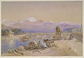
Image:Ganga canal.jpg|The Ganges Canal.
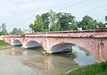
Image:Ganges canal oldEIC bridge1854b.jpg|The same East India Company bridge as in the lead paragraph photographed from the other side.
Image:Ganges canal oldEIC bungalow1854b.jpg|An old EIC engineer's bungalow on the canal.
Image:Ganges canal oldEIC locks1854b.jpg|150 year old locks on the canal.
Canal
Canals are man-made channels for water. There are two types of canal:#Waterways: navigable transportation canals used for carrying ships and boats shipping goods and conveying people, further subdivided into two kinds:...
system that irrigates the Doab
Doab
A Doab is a term used in India and Pakistan for a "tongue" or tract of land lying between two confluent rivers...
region between the Ganges River
Ganges River
The Ganges or Ganga, , is a trans-boundary river of India and Bangladesh. The river rises in the western Himalayas in the Indian state of Uttarakhand, and flows south and east through the Gangetic Plain of North India into Bangladesh, where it empties into the Bay of Bengal. By discharge it...
and the Yamuna River in India
India
India , officially the Republic of India , is a country in South Asia. It is the seventh-largest country by geographical area, the second-most populous country with over 1.2 billion people, and the most populous democracy in the world...
.
The canal is primarily an irrigation canal, although parts of it were also used for navigation, primarily for its construction materials. Separate navigation channels with lock gates were provided on this system for boats to negotiate falls. Originally constructed from 1842 to 1854, for an original head discharge of 6000 ft³/s. The Upper Ganges Canal has since been enlarged gradually for the present head discharge of 10,500 ft³/s (295 m³/s). The system consists of main canal of 272 miles and about 4000 miles long distribution channels. The canal system irrigates nearly 9,000 km² of fertile agricultural land in ten districts of Uttar Pradesh
Uttar Pradesh
Uttar Pradesh abbreviation U.P. , is a state located in the northern part of India. With a population of over 200 million people, it is India's most populous state, as well as the world's most populous sub-national entity...
and Uttarakhand
Uttarakhand
Uttarakhand , formerly Uttaranchal, is a state in the northern part of India. It is often referred to as the Land of Gods due to the many holy Hindu temples and cities found throughout the state, some of which are among Hinduism's most spiritual and auspicious places of pilgrimage and worship...
. Today the canal is the source of agricultural prosperity in much of these states, and the irrigation departments of these states actively maintain the canal against a fee system charged from users.
There are some small hydroelectric plants on the canal capable of generating about 33MW if running at full capacity these are at
Nirgajini, Chitaura, Salawa, Bhola, Jani, Jauli and Dasna .
Structure
constitutes several branches below Aligarh.
Upper Ganges Canal
The Upper Ganges canal is the original Ganges Canal, which starts at theBhimgoda Barrage
Bhimgoda Barrage
The Bhimgoda Barrage, also referred to as the Bhimgoda Weir or Bhimgoda Head Works, is a barrage on the Ganges River at Har ki Pauri near Haridwar in Haridwar district, Uttarakhand, India. Built as the headworks of the Upper Ganges Canal, an initial barrage was completed by 1854 and replaced twice;...
near Har ki Pauri
Har ki Pauri
Har Ki Pauri is a famous ghat on the banks of the Ganges in Haridwar in Uttarakhand state in India. This revered place is the major landmark of the holy city of Haridwar. Literally, "Har" means "Lord Shiva", "ki" means "of" and "paudi" means "steps". Lord Shiva and Lord Vishnu are believed to...
at
Haridwar
Haridwar
Haridwar is an important pilgrimage city and municipality in the Haridwar district of Uttarakhand, India...
, traverses Meerut and Bulandshahr and continues to Nanu in
Aligarh district
Aligarh District
Aligarh District is a district in the northern Indian state of Uttar Pradesh. Its district seat is located in the city of Aligarh .The Aligarh District belongs to Aligarh Division...
, where it bifurcates into the
Kanpur and Etawah
Etawah
Etawah is a city on the Yamuna River in the state of Uttar Pradesh in India. It is the administrative headquarters of Etawah District. The city was an important center for the Revolt of 1857 . Also is the place of sangam or confluence between Yamuna and Chambal...
branches.
A highway running along the Upper Ganges canal has been proposed several times. In 2010, it was turned since it would "lead to uprooting of around 100,000 trees, damaging the Fauna & Flora and destroying the natural habitat of wildlife" At some places boundary of Hastinapur Wildlife Sanctuary is as close as about 500-600 meter away only from the proposed UGC Expressway site. There are two other substitute roads - NH-58 and the KAWAR MARG already existing to transportation. An environmental activist Vijaypal Baghel is opposing strongly of this project. Also, the proposal by the Mayavati government was criticized as trying to subvert the environmental issues by splitting the proposal in five different parts.
Lower Ganges Canal
A channel from a weirWeir
A weir is a small overflow dam used to alter the flow characteristics of a river or stream. In most cases weirs take the form of a barrier across the river that causes water to pool behind the structure , but allows water to flow over the top...
at Narora
Narora
Narora is located on the banks of river Ganges, in district Bulandshahar, Uttar Pradesh. A nuclear power plant is located in its vicinity.-Geography:Narora is located at . It has an average elevation of . It is about away from Delhi.-Demographics:...
intersects the canal system
48 km downstream from Nanu, and continues past the Sengar River and Sersa River, past Shikohabad
Shikohabad
Shikohabad is a city and a municipal board in the Firozabad district of the Indian state of Uttar Pradesh. The city has been famous since the British Period for its Glass Industry. Shikihabad has one of the oldest Bulb and Electric Tube manufacturing units , established in 1951, which was the...
in Mainpuri district
Mainpuri District
Mainpuri district is one of the districts of Uttar Pradesh state of India, and Mainpuri town is the district headquarters. Mainpuri district is a part of Agra division.-Demographics:...
to become the Bhognipur branch which was opened in 1880. This branch, starting at
village Jera in Mainpuri district, runs for 166 km to reach Kanpur.
At kilometre 64 the Balrai escape carries excess water through a 6.4 km. channel through the ravines to discharge into the Yamuna. This branch has 386 km. of distributary channels.
The Bhognipur branch, together with the Kanpur and Etawah branches, is known as the Lower Ganges Canal. The old channels of the old Kanpur and Etawah branches between Nanu and the point of intersection by the channel from Narora, are known as "stumps", and are utilized only when the supply of water in the lower Ganges system runs low. The main branch of the river passes Kanpur (behind IIT Kanpur) before breaking into several branches. A branch of it terminates Kanpur Jal Sansthan which comes from behind J. K. Temple
J. K. Temple
The JK Temple is a temple in the Indian city of Kanpur. Considered to be a unique blend of ancient and modern architecture, its mandapas have been constructed with high roof for adequate ventilation of light and air. The J. K. Trust has constructed this temple.-Location:Located in commercial and...
.
History
Crore
A crore is a unit in the Indian number system equal to ten million , or 100 lakhs. It is widely used in India, Bangladesh, Nepal, and Pakistan....
) rupees was spent on relief works, resulting in considerable loss of revenue to the British East India Company
British East India Company
The East India Company was an early English joint-stock company that was formed initially for pursuing trade with the East Indies, but that ended up trading mainly with the Indian subcontinent and China...
.
One of the moving forces behind the canal was Colonel Proby Cautley
Proby Cautley
Sir Proby Thomas Cautley KCB , English engineer and palaeontologist, born in Suffolk, is best known for conceiving and supervising the construction of the Ganges canal in India...
, who was confident that a 500-kilometre canal was feasible. There were many obstacles and objections to his project, mostly financial, but Cautley persevered and
after spending six months walking and riding through the area taking measurements, he managed to persuade the British East India Company to sponsor the project.
Digging of the canal began in April 1842. Cautley had to make his own bricks, brick kiln
Kiln
A kiln is a thermally insulated chamber, or oven, in which a controlled temperature regime is produced. Uses include the hardening, burning or drying of materials...
and mortar. Initially, he was opposed by the Hindu
Hindu
Hindu refers to an identity associated with the philosophical, religious and cultural systems that are indigenous to the Indian subcontinent. As used in the Constitution of India, the word "Hindu" is also attributed to all persons professing any Indian religion...
priests at Haridwar, who felt that the waters of the holy river Ganges would be imprisoned but Cautley pacified them by agreeing to leave a gap in the dam from where the water could flow unchecked. He further appeased the priests by undertaking the repair of bathing ghats along the river. He also inaugurated the dam by the worship of Lord Ganesh, the god of good beginnings.
The dam was faced with many complications- among them was the problem of the mountainous streams that threatened the canal. Near Roorkee
Roorkee
Roorkee is a city and seat of a municipal council in Uttarakhand, in far northern India. It is located on the banks of the Ganges canal on the national highway between Delhi and Dehradun. Roorkee is known for Roorkee Cantonment, one of the country's oldest cantonments, and the headquarters of...
, the land fell away sharply and Cautley had to build an aqueduct to carry the canal for half a kilometre. As a result, at Roorkee the canal is 25 metres higher than the original river.
When the canal formally opened on 8 April 1854, its main channel was 348 miles (560.1 km) long, its branches 306 miles (492.5 km) long and the various tributaries over 3000 miles (4,828 km) long. After irrigation was commenced in May 1855, over 767000 acres (3,103.9 km²) in 5,000 villages were irrigated.
In 1877 the whole canal system of the lower Doabs underwent radical alteration. The Lower Ganges Canal, with a feed from a channel from Narora, was constructed into the ghar tract of Etawah, and became the Bhognipur branch.
Around 1900, according to the Nuttall Encyclopedia of 1907, it had a total extent of 3700 miles (5,954.6 km), of which 500 miles (804.7 km) were navigable.
Image:Ganga canal.jpg|The Ganges Canal.
Image:Ganges canal oldEIC bridge1854b.jpg|The same East India Company bridge as in the lead paragraph photographed from the other side.
Image:Ganges canal oldEIC bungalow1854b.jpg|An old EIC engineer's bungalow on the canal.
Image:Ganges canal oldEIC locks1854b.jpg|150 year old locks on the canal.