
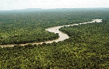
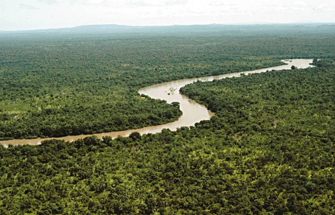
Gambia River
Encyclopedia

River
A river is a natural watercourse, usually freshwater, flowing towards an ocean, a lake, a sea, or another river. In a few cases, a river simply flows into the ground or dries up completely before reaching another body of water. Small rivers may also be called by several other names, including...
in West Africa
West Africa
West Africa or Western Africa is the westernmost region of the African continent. Geopolitically, the UN definition of Western Africa includes the following 16 countries and an area of approximately 5 million square km:-Flags of West Africa:...
, running 1130 kilometres (702.2 mi) from the Fouta Djallon
Fouta Djallon
Fouta Djallon is a highland region in the centre of Guinea, West Africa. The indigenous name is Fuuta-Jaloo...
plateau in north Guinea
Guinea
Guinea , officially the Republic of Guinea , is a country in West Africa. Formerly known as French Guinea , it is today sometimes called Guinea-Conakry to distinguish it from its neighbour Guinea-Bissau. Guinea is divided into eight administrative regions and subdivided into thirty-three prefectures...
westward through Senegal
Senegal
Senegal , officially the Republic of Senegal , is a country in western Africa. It owes its name to the Sénégal River that borders it to the east and north...
and The Gambia
The Gambia
The Republic of The Gambia, commonly referred to as The Gambia, or Gambia , is a country in West Africa. Gambia is the smallest country on mainland Africa, surrounded by Senegal except for a short coastline on the Atlantic Ocean in the west....
to the Atlantic Ocean
Atlantic Ocean
The Atlantic Ocean is the second-largest of the world's oceanic divisions. With a total area of about , it covers approximately 20% of the Earth's surface and about 26% of its water surface area...
at the city of Banjul
Banjul
-Transport:Ferries sail from Banjul to Barra. The city is served by the Banjul International Airport. Banjul is on the Trans–West African Coastal Highway connecting it to Dakar and Bissau, and will eventually provide a paved highway link to 11 other nations of ECOWAS.Banjul International Airport...
. It is navigable for about half that length.
The river is known largely because of The Gambia, the smallest country in mainland Africa, which consists of little more than the downstream half of the river and its two banks.
From the Fouta Djallon, the river runs northwest into the Tambacounda Region
Tambacounda Region
Tambacounda, formerly known as Sénégal Orientale, is a region of Senegal. It used to be part of the Mali Empire before the borders were created to separate Mali from Senegal. Tambacounda is physically the largest of Senegal's 11 regions, but is sparsely populated and its economy lags behind the...
of Senegal, where it flows through the Parc National du Niokolo Koba, then is joined by the Nieri Ko and Koulountou before entering The Gambia at Fatoto
Fatoto
Fatoto is a small town in eastern Gambia on the Gambia River. It is located in Kantora District in the Upper River Division. As of 2009, it has an estimated population of1,685....
. At this point the river runs generally west, but in a meandering course with a number of oxbows
Oxbow lake
An oxbow lake is a U-shaped body of water formed when a wide meander from the main stem of a river is cut off to create a lake. This landform is called an oxbow lake for the distinctive curved shape, named after part of a yoke for oxen. In Australia, an oxbow lake is called a billabong, derived...
, and about 100 km from its mouth it gradually widens, to over 10 km wide where it meets the sea.
Near the mouth of the river, near Juffure, is James Island
James Island (The Gambia)
James Island is an island in the Gambia River, 30 km from the river mouth and near Juffureh in the country of The Gambia. On 6 February 2011 it was renamed Kunta Kinteh Island to give the Island a Gambian name. Fort James is located on the island...
, a place used in the slave trade which is now a UNESCO
UNESCO
The United Nations Educational, Scientific and Cultural Organization is a specialized agency of the United Nations...
World Heritage Site
World Heritage Site
A UNESCO World Heritage Site is a place that is listed by the UNESCO as of special cultural or physical significance...
.
The aquatic fauna in the Gambia River basin
Drainage basin
A drainage basin is an extent or an area of land where surface water from rain and melting snow or ice converges to a single point, usually the exit of the basin, where the waters join another waterbody, such as a river, lake, reservoir, estuary, wetland, sea, or ocean...
is closely associated with that of the Sénégal River
Sénégal River
The Sénégal River is a long river in West Africa that forms the border between Senegal and Mauritania.The Sénégal's headwaters are the Semefé and Bafing rivers which both originate in Guinea; they form a small part of the Guinean-Malian border before coming together at Bafoulabé in Mali...
basin, and the two are usually combined under a single ecoregion
Ecoregion
An ecoregion , sometimes called a bioregion, is an ecologically and geographically defined area that is smaller than an ecozone and larger than an ecosystem. Ecoregions cover relatively large areas of land or water, and contain characteristic, geographically distinct assemblages of natural...
known as the Senegal-Gambia Catchments. Although the species richness
Species richness
Species richness is the number of different species in a given area. It is represented in equation form as S.Species richness is the fundamental unit in which to assess the homogeneity of an environment. Typically, species richness is used in conservation studies to determine the sensitivity of...
is moderately high, only three species of frogs and one fish are endemic to this ecoregion.