

GNSS positioning calculation
Encyclopedia
The global navigation satellite system
(GNSS) positioning for receiver's position is derived through the calculation steps, or algorithm, given below.
In essence, a GNSS receiver measures the transmitting time of GNSS signals emitted from four or more GNSS satellites and these measurements are used to obtain its position (i.e., spatial coordinates) and reception time.

in which is the orbital eccentric anomaly
of satellite ,
,  is the mean anomaly
, is the eccentricity
, and .
.
Global Navigation Satellite System
A satellite navigation or SAT NAV system is a system of satellites that provide autonomous geo-spatial positioning with global coverage. It allows small electronic receivers to determine their location to within a few metres using time signals transmitted along a line-of-sight by radio from...
(GNSS) positioning for receiver's position is derived through the calculation steps, or algorithm, given below.
In essence, a GNSS receiver measures the transmitting time of GNSS signals emitted from four or more GNSS satellites and these measurements are used to obtain its position (i.e., spatial coordinates) and reception time.
Calculation steps
- A global navigation satellite systemGlobal Navigation Satellite SystemA satellite navigation or SAT NAV system is a system of satellites that provide autonomous geo-spatial positioning with global coverage. It allows small electronic receivers to determine their location to within a few metres using time signals transmitted along a line-of-sight by radio from...
(GNSS) receiver measures the apparent transmitting time, , or "phase", of GNSS signals emitted from four or more GNSS satelliteSatelliteIn the context of spaceflight, a satellite is an object which has been placed into orbit by human endeavour. Such objects are sometimes called artificial satellites to distinguish them from natural satellites such as the Moon....
s ( ), simultaneously.
 - GNSS satellites broadcast the messages of satellites' ephemerisEphemerisAn ephemeris is a table of values that gives the positions of astronomical objects in the sky at a given time or times. Different kinds of ephemerides are used for astronomy and astrology...
, , and intrinsic clock bias (i.e., clock advance),
  as the functions of (atomicAtomic clockAn atomic clock is a clock that uses an electronic transition frequency in the microwave, optical, or ultraviolet region of the electromagnetic spectrum of atoms as a frequency standard for its timekeeping element...
) standard timeStandard timeStandard time is the result of synchronizing clocks in different geographical locations within a time zone to the same time rather than using the local meridian as in local mean time or solar time. Historically, this helped in the process of weather forecasting and train travel. The concept...
, e.g., GPST. - The transmitting time of GNSS satellite signals,
 , is thus derived from the non-closed-form equations
  and
and  , where
  is the relativisticTheory of relativityThe theory of relativity, or simply relativity, encompasses two theories of Albert Einstein: special relativity and general relativity. However, the word relativity is sometimes used in reference to Galilean invariance....
clock bias, periodically risen from the satellite's orbital eccentricityOrbital eccentricityThe orbital eccentricity of an astronomical body is the amount by which its orbit deviates from a perfect circle, where 0 is perfectly circular, and 1.0 is a parabola, and no longer a closed orbit...
and Earth's gravity field. The satellite's position and velocity are determined by :
:  and
and  .
. - In the field of GNSS, "geometric range",
 , is defined as straight range from
  to
to  in inertial frame (e.g., Earth Centered InertialEarth Centered InertialEarth-centered inertial coordinate frames have their origins at the center of mass of the Earth. ECI frames are called inertial in contrast to the Earth-centered, Earth-fixed frames which rotate in inertial space in order to remain fixed with respect to the surface of the Earth...
(ECI) one) not in rotating frame. - The receiver's position,
 , and reception time,
  , satisfy the light-cone equation of
  in inertial frame, where
  is the speed of lightSpeed of lightThe speed of light in vacuum, usually denoted by c, is a physical constant important in many areas of physics. Its value is 299,792,458 metres per second, a figure that is exact since the length of the metre is defined from this constant and the international standard for time...
. The signal transit time is .
. - The above is extended to the satellite-navigationGlobal Navigation Satellite SystemA satellite navigation or SAT NAV system is a system of satellites that provide autonomous geo-spatial positioning with global coverage. It allows small electronic receivers to determine their location to within a few metres using time signals transmitted along a line-of-sight by radio from...
positioningPositioningPositioning may refer to:* Positioning , creating an identity in the minds of a target market* Positioning , reader context* Positioning , a technology to approximate where a mobile phone temporarily resides...
equationEquationAn equation is a mathematical statement that asserts the equality of two expressions. In modern notation, this is written by placing the expressions on either side of an equals sign , for examplex + 3 = 5\,asserts that x+3 is equal to 5...
, , where
  is atmospheric delay (= ionospheric delay + tropospheric delay) along signal path and
  is the measurement error.
 - The Gauss–Newton method can be used to solve the nonlinear least-squares problem for the solution:
 , where
  . Note that
  should be regarded as a function of
  and
and  .
.
- The posterior distribution of
 and
and  is proportional to
  , whose modeMode (statistics)In statistics, the mode is the value that occurs most frequently in a data set or a probability distribution. In some fields, notably education, sample data are often called scores, and the sample mode is known as the modal score....
is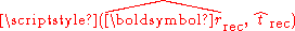 .
. - The posterior distribution of
 is proportional to
  .
.
The GPS case
- For Global Positioning SystemGlobal Positioning SystemThe Global Positioning System is a space-based global navigation satellite system that provides location and time information in all weather, anywhere on or near the Earth, where there is an unobstructed line of sight to four or more GPS satellites...
(GPS), the non-closed-form equations in step 3 result in
in which
is the orbital eccentric anomalyEccentric anomaly
In celestial mechanics, the eccentric anomaly is an angular parameter that defines the position of a body that is moving along an elliptic Kepler orbit.For the point P orbiting around an ellipse, the eccentric anomaly is the angle E in the figure...
of satellite
, is the mean anomalyMean anomaly
In celestial mechanics, the mean anomaly is a parameter relating position and time for a body moving in a Kepler orbit. It is based on the fact that equal areas are swept at the focus in equal intervals of time....
,
is the eccentricityOrbital eccentricity
The orbital eccentricity of an astronomical body is the amount by which its orbit deviates from a perfect circle, where 0 is perfectly circular, and 1.0 is a parabola, and no longer a closed orbit...
, and
.
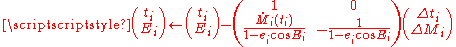
- The above can be solved by using the bivariate Newton-Raphson method on
 and
and  . Two times of iteration will be necessary and sufficient in most cases. Its iterative update will be described by using the approximated inverseInverseInverse may refer to:* Inverse , a type of immediate inference from a conditional sentence* Inverse , a program for solving inverse and optimization problems...
of JacobianJacobianIn vector calculus, the Jacobian matrix is the matrix of all first-order partial derivatives of a vector- or scalar-valued function with respect to another vector. Suppose F : Rn → Rm is a function from Euclidean n-space to Euclidean m-space...
matrix as follows:
- Tropospheric delay should not be ignored, while the Global Positioning SystemGlobal Positioning SystemThe Global Positioning System is a space-based global navigation satellite system that provides location and time information in all weather, anywhere on or near the Earth, where there is an unobstructed line of sight to four or more GPS satellites...
(GPS) specification doesn't mention it clearly.
Note
- In the field of GNSS,
 is called pseudorangePseudorangeThe pseudorange is the pseudo distance between a satellite and a navigation satellite receiver —for instance Global Positioning System receivers....
, where is a provisional reception time of the receiver.
  is called receiver's clock bias (i.e., clock advance).
 - Standard GNSS receivers output
 and
and  per an observation epochEpoch (astronomy)In astronomy, an epoch is a moment in time used as a reference point for some time-varying astronomical quantity, such as celestial coordinates, or elliptical orbital elements of a celestial body, where these are subject to perturbations and vary with time...
. - The temporal variation in the relativistic clock bias of satellite is linear if its orbit is circular (and thus its velocity is uniform in inertial frame).
- The signal transit time is expressed as
 , whose right side is round-off-errorRound-off errorA round-off error, also called rounding error, is the difference between the calculated approximation of a number and its exact mathematical value. Numerical analysis specifically tries to estimate this error when using approximation equations and/or algorithms, especially when using finitely many...
resistive during calculation. - The geometric range is calculated as
 , where the Earth-centred Earth-fixedECEFECEF stands for Earth-Centered, Earth-Fixed, and is a Cartesian coordinate system, and is sometimes known as a "conventional terrestrial" system. It represents positions as an X, Y, and Z coordinate. The point is defined as the center of mass of the earth, hence the name Earth-Centered...
(ECEF) rotating frame (e.g., WGS84 or ITRF) is used in the right side and is the Earth rotating matrix with the argument of the signal transit time. The matrix can be factorized as
  .
. - The line-of-sight unit vector of satellite observed at
 is described as:
  .
. - The satellite-navigationGlobal Navigation Satellite SystemA satellite navigation or SAT NAV system is a system of satellites that provide autonomous geo-spatial positioning with global coverage. It allows small electronic receivers to determine their location to within a few metres using time signals transmitted along a line-of-sight by radio from...
positioningPositioningPositioning may refer to:* Positioning , creating an identity in the minds of a target market* Positioning , reader context* Positioning , a technology to approximate where a mobile phone temporarily resides...
equationEquationAn equation is a mathematical statement that asserts the equality of two expressions. In modern notation, this is written by placing the expressions on either side of an equals sign , for examplex + 3 = 5\,asserts that x+3 is equal to 5...
may be expressed by using the variables, and
and  .
. - The nonlinearityNonlinearityIn mathematics, a nonlinear system is one that does not satisfy the superposition principle, or one whose output is not directly proportional to its input; a linear system fulfills these conditions. In other words, a nonlinear system is any problem where the variable to be solved for cannot be...
of the vertical dependency of tropospheric delay degrades the convergence efficiency in the Gauss–Newton iterations in step 7. - The above notation is different from that in the Wikipedia articles, 'Position calculation introduction' and 'Position calculation advanced', of Global Positioning SystemGlobal Positioning SystemThe Global Positioning System is a space-based global navigation satellite system that provides location and time information in all weather, anywhere on or near the Earth, where there is an unobstructed line of sight to four or more GPS satellites...
(GPS).