

Fukuoka Castle
Encyclopedia
Japanese castle
' were fortresses composed primarily of wood and stone. They evolved from the wooden stockades of earlier centuries, and came into their best-known form in the 16th century...
located in Chūō-ku, Fukuoka
Chuo-ku, Fukuoka
is one of the seven wards of Fukuoka city in Japan. The ward is located in the center of the city.It includes Tenjin and Daimyō which are among the largest downtown areas in Kyūshū, Nagahama, which is known for its fish market, and Ōhori Park.-Main facilities:...
, Japan
Japan
Japan is an island nation in East Asia. Located in the Pacific Ocean, it lies to the east of the Sea of Japan, China, North Korea, South Korea and Russia, stretching from the Sea of Okhotsk in the north to the East China Sea and Taiwan in the south...
. The castle is also known as Maizuru Castle (舞鶴城 Maizurujō) or Seki Castle (石城 Sekijō). Completed in the early Edo period
Edo period
The , or , is a division of Japanese history which was ruled by the shoguns of the Tokugawa family, running from 1603 to 1868. The political entity of this period was the Tokugawa shogunate....
for tozama
Tozama
A ' was a daimyo who was considered an outsider by the rulers of Japan. The term came into use in the Kamakura period and continued until the end of the Edo period.-Edo period:...
daimyo
Daimyo
is a generic term referring to the powerful territorial lords in pre-modern Japan who ruled most of the country from their vast, hereditary land holdings...
Kuroda Nagamasa
Kuroda Nagamasa
was a daimyo of Japan. He was the son of Kuroda Kanbei.In 1577, When Nagamasa was a small child, his father was condemned as a spy by Oda Nobunaga. Nagamasa was kidnapped and nearly killed as a hostage. Takenaka Hanbei ended up rescuing him....
, it has been decreed a historic site
Historic site
A historic site is an official location where pieces of political, military or social history have been preserved. Historic sites are usually protected by law, and many have recognized with the official national historic site status...
by the Japanese government.
History
The castle lies in the centre of FukuokaFukuoka, Fukuoka
is the capital city of Fukuoka Prefecture and is situated on the northern shore of the island of Kyushu in Japan.Voted number 14 in a 2010 poll of the World's Most Livable Cities, Fukuoka is praised for its green spaces in a metropolitan setting. It is the most populous city in Kyushu, followed by...
, on top of Fukusaki hill. The acts as a natural moat on the eastern side of the castle, while the western side uses a mudflat
Mudflat
Mudflats or mud flats, also known as tidal flats, are coastal wetlands that form when mud is deposited by tides or rivers. They are found in sheltered areas such as bays, bayous, lagoons, and estuaries. Mudflats may be viewed geologically as exposed layers of bay mud, resulting from deposition of...
as a natural moat. Hakata
Hakata-ku, Fukuoka
is one of the seven wards of Fukuoka City, Fukuoka Prefecture, Japan. It is best known as the location of Fukuoka's main train station, Hakata Station.-Geography:...
, a ward with a bustling port
Port
A port is a location on a coast or shore containing one or more harbors where ships can dock and transfer people or cargo to or from land....
, is located on the opposite side of the Nakagawa River to the east. The castle town
Castle town
A castle town is a settlement built adjacent to or surrounding a castle. Castle towns are common in Medieval Europe. Good example include small towns like Alnwick and Arundel, which are still dominated by their castles...
was set on the northern side, facing the sea.
Much of the castle grounds has been converted to Maizuru Park, which houses several sports facilities, a courthouse, and an art museum. Heiwadai Baseball Stadium
Heiwadai Stadium
was a stadium in Fukuoka, Fukuoka, Japan. It was primarily used for baseball and was home of the Nishitetsu Lions until they moved to Tokorozawa and the Seibu Dome in 1979. The stadium was opened in 1928 and had a capacity of 32,000 people....
, the past home field of the Nishitetsu Lions and Fukuoka Daiei Hawks
Fukuoka SoftBank Hawks
The are a Japanese baseball team based in Fukuoka, Fukuoka Prefecture. The team was bought on January 28, 2005 by the SoftBank Corporation.The team was formerly known as the Fukuoka Daiei Hawks. In 1988, Daiei bought the team from Osaka's Nankai Electric Railway Co., and its headquarters were...
, was also located on the castle grounds. Some of the castle's gate
Gate
A gate is a point of entry to a space enclosed by walls, or a moderately sized opening in a fence. Gates may prevent or control entry or exit, or they may be merely decorative. Other terms for gate include yett and port...
s and yagura
Yagura
Yagura is the Japanese word for "tower" or "turret." The word is most often seen in reference to structures within Japanese castle compounds, but can be used in a variety of other situations as well. The bandstand tower erected for Bon Festival is often called a yagura, as are similar structures...
s are preserved inside of the park, one of which have been marked as important historical artifacts by the Japanese government.
The remnants of a foreign embassy were discovered under the castle grounds in 1987, showing that the castle was a vital geographical checkpoint even into the Heian period
Heian period
The is the last division of classical Japanese history, running from 794 to 1185. The period is named after the capital city of Heian-kyō, or modern Kyōto. It is the period in Japanese history when Buddhism, Taoism and other Chinese influences were at their height...
. This is the only Korokan remnant found in all of Japan.
Construction
In 1600, NagamasaKuroda Nagamasa
was a daimyo of Japan. He was the son of Kuroda Kanbei.In 1577, When Nagamasa was a small child, his father was condemned as a spy by Oda Nobunaga. Nagamasa was kidnapped and nearly killed as a hostage. Takenaka Hanbei ended up rescuing him....
received huge rewards of land in Chikuzen Province
Chikuzen Province
was an old province of Japan in the area that is today part of Fukuoka Prefecture in Kyūshū. It was sometimes called , with Chikugo Province. Chikuzen bordered Buzen, Bungo, Chikugo, and Hizen Provinces....
for their contributions at the Battle of Sekigahara
Battle of Sekigahara
The , popularly known as the , was a decisive battle on October 21, 1600 which cleared the path to the Shogunate for Tokugawa Ieyasu...
, and moved into Najima Castle (名島城 -jō) to form the Fukuoka han
Han (Japan)
The or domain was the name of the estate belonging to a warrior in Japan after the 17th century. The fiefs of the daimyos of the samurai class of Japan during the Edo period were called han.-Edo period:...
. Najima Castle had been created by Tachibana Akitoshi and was expanded by Kobayakawa Takakage
Kobayakawa Takakage
was a samurai retainer of Toyotomi Hideyoshi during Japan's Sengoku period, and the son of Mōri Motonari. Adopted by the head of the Kobayakawa clan, Takakage took his name, and succeeded his adoptive father to become head of the Kobayakawa clan following his death in 1545.As head of the Kobayakawa...
, but was much too small to accommodate a large han, leading to the selection of Fukusaki hill as the new castle site.
Construction began in 1601 (Keichō
Keicho
was a after Bunroku and before Genna. This period spanned from October 1596 to July 1615. The reigning emperors were and .-Change of era:* 1596 : The era name was changed to Keichō to mark the passing of various natural disasters...
year 6). Yoshitaka was already an expert at establishing fortifications, and Noguchi Kazunari, a stonemason who had worked on Edo Castle
Edo Castle
, also known as , is a flatland castle that was built in 1457 by Ōta Dōkan. It is located in Chiyoda in Tokyo, then known as Edo, Toshima District, Musashi Province. Tokugawa Ieyasu established the Tokugawa shogunate here. It was the residence of the shogun and location of the shogunate, and also...
and Osaka Castle
Osaka Castle
is a Japanese castle in Chūō-ku, Osaka, Japan.Originally called Ozakajō, it is one of Japan's most famous castles, and played a major role in the unification of Japan during the sixteenth century of the Azuchi-Momoyama period.-Description:...
, also directed the construction. Completed in 1607 (Keichō
Keicho
was a after Bunroku and before Genna. This period spanned from October 1596 to July 1615. The reigning emperors were and .-Change of era:* 1596 : The era name was changed to Keichō to mark the passing of various natural disasters...
year 12) after seven years of work, the castle is said to have contained an impressive 47 yaguras, and covered an area of 47,000 square metres (largest in the Kyūshū
Kyushu
is the third largest island of Japan and most southwesterly of its four main islands. Its alternate ancient names include , , and . The historical regional name is referred to Kyushu and its surrounding islands....
region). Katō Kiyomasa
Kato Kiyomasa
was a Japanese daimyō of the Azuchi-Momoyama and Edo period.-Origins and early career:Kiyomasa was born in Owari Province to Katō Kiyotada. Kiyotada's wife, Ito, was a cousin of Toyotomi Hideyoshi's mother. Kiyotada died while his son was still young...
of the nearby Kumamoto han lauded the castle for its grandeur. The dry stone
Dry stone
Dry stone is a building method by which structures are constructed from stones without any mortar to bind them together. Dry stone structures are stable because of their unique construction method, which is characterized by the presence of a load-bearing facade of carefully selected interlocking...
fortification designed by Noguchi was especially impressive, giving the castle the name "Sekijō" (literally "Stone Castle").
The castle and castle town were renamed to "Fukuoka" from "Fukusaki," after Fukuoka of Bizen Province
Bizen Province
was a province of Japan on the Inland Sea side of Honshū, in what is today the southeastern part of Okayama Prefecture. It was sometimes called , with Bitchu and Bingo Provinces. Bizen borders Mimasaka, Harima, and Bitchū Provinces....
(current Setouchi, Okayama
Setouchi, Okayama
is a city located in the southern part of Okayama Prefecture, Japan. As of 2004, the city has a population of 39,377. The total area is 125.51 km²....
), where the Kuroda family had originated.
Several minor repairs were made during the Edo period, and a full-scale renovation was conducted during the Bakumatsu
Late Tokugawa shogunate
, literally "end of the curtain", are the final years of the Edo period when the Tokugawa shogunate came to an end. It is characterized by major events occurring between 1853 and 1867 during which Japan ended its isolationist foreign policy known as sakoku and transitioned from a feudal shogunate...
period.
In 1871, (Meiji
Meiji period
The , also known as the Meiji era, is a Japanese era which extended from September 1868 through July 1912. This period represents the first half of the Empire of Japan.- Meiji Restoration and the emperor :...
year 4) the abolition of the han system
Abolition of the han system
The was an act, in 1871, of the new Meiji government of the Empire of Japan to replace the traditional feudal domain system and to introduce centralized government authority . This process marked the culmination of the Meiji Restoration in that all daimyo were required to return their authority...
forced the abandonment of the castle. Many of the buildings inside the castle grounds were taken down or moved to other locations.
Taisho period
The , or Taishō era, is a period in the history of Japan dating from July 30, 1912 to December 25, 1926, coinciding with the reign of the Taishō Emperor. The health of the new emperor was weak, which prompted the shift in political power from the old oligarchic group of elder statesmen to the Diet...
year 9) the kinen-yagura was relocated to Taishō temple in Yahata Higashi-ku, Kitakyushu
Yahata Higashi-ku, Kitakyushu
is a ward of Kitakyūshū, Fukuoka, Japan. It is the second smallest ward in Kitakyūshū after Tobata ward at only 36.36 square kilometres. Residents have a very high average age, one of the highest in Japan. The population was 77,077 at the end of September 2003....
. The building was moved back to its original location in 1983.
On August 29, 1957, the castle was decreed a historic site by the Japanese government. Additional gates and yaguras were also decreed historical artifacts by the prefectural government in 1952, 1961, 1971 and 1957.
Part of the Second Main gate was set on fire by a vandal in 2000. The reconstruction of the gate is currently under way.
Selection of Locale
After the overwhelming victory in the battle of Sekigahara in 1600, Kuroda Nagamasa was installed as the ruler of Chikuzen province and received this province in exchange for his six counties in Buzen Province, and then he established his quarters at Najima Castle with his father Josui.Najima Castle was located on a peninsula projecting into Hakata Bay on the north of the estuary of the Tatara River. The castle fundamentally consisted of the hon-maru, the ni-no-maru, and the san-no-maru, respectively ranging from west to east, and extending for over 900 metres(2953 ft). Built by Kobayakawa Takakage, one of illustrious generals of Japan, it was an impregnable castle. However, when the aspects of politics and economics were considered, it turned out to be undesirable as the administrative centre of the province, for it seemed impossible to construct an extensive castle town because of the river on the south, the sea on the north and the west, and the foothills on the east. On top of that, the castle was located far away from Hakata, a large business centre. Accordingly, Nagamasa and Josui made a survey of four sites—Sumiyoshi, Hakozaki, Aratsu-yama hill (present-day Nishi-koen park), and Fukuzaki. After careful consideration, Fukuzaki was chosen as the castle site.
Fukuzaki, in the proximity of Hakata, was a place where a castle town could easily be constructed, and it was valuable as a naval port; furthermore, it had geostrategic advantages; it was surrounded by a cove, rivers, and hills. Thus Fukuzaki was chosen by Josui, which is present-day Fukuoka, now one of the largest cities in Japan.
Construction
The construction of Fukuoka Castle began in 1601. The plan of this castle is considered to have been directed by Kuroda Nagamasa. An old document suggests that Kuroda Nagamasa planned a gate and its surrounding area after many consultations with his distinguished commanding officers. The construction of Fukuoka Castle was completed in 1607.The process of construction is fairly well known by means of archaeological and geological research and old documents; from these details can be deduced which develop understanding of the process of the castle construction.
Because there had been a range of hills from the Akasaka-yama hill (present-day Sakurazaka 2 chome), which is about 30 metres (98 ft) above sea level, to the hill which was designated to become the site of the hon-maru, an area to the south of the castle was excavated to form a moat. The hills to the south of the moat were also excavated and altered to become gently sloping hills. The top section of a hillock, which lay in the northwest of the inner castle, was also truncated because it was higher than the hon-maru. The hillock was then used as the site for a retirement residence for Kuroda Josui.
A cove or an inlet on the west of the inner castle, in which Ōhori Park
Ōhori Park
is a park in Chūō-ku, Fukuoka, Japan.The name Ōhori means a trench and it derives from the fact that Kuroda Nagamasa, the old lord of Fukuoka, reclaimed the land called Kusagae which was facing Hakata Bay and made a trench for the Fukuoka Castle....
and Arato are now situated, was utilized for the Ohori Moat (Big Moat) in the cove's southern half, and for a town in its northern half by a reclaiming and dredging process. At the same time the Hii (Tajima) River, which was flowing into the cove, was diverted from its course to the west.
On the west of the inner castle, two linear moats were excavated from the inner castle to the confluence of the Shiju River (present-day Yakuin-shin River) and the Naka River.
This large scale construction required a great number of stones. The analysis of the components of the stone reveals that they were the same kind of stones as those found in the island of Nokonoshima, Itoshima, Sawara, Kashii, and the region from Noma to Teratsuka. According to old books, the stones and buildings of the dismantled Najima Castle were shipped to Fukuoka and the stones which had been used for the Genko-borui walls (walls built to thwart the Mongolian invaders) and the ancient burial mounds in and around Hirao Village and the Hirao-yama hills were also reused for Fukuoka Castle. From these facts it can be inferred that the constructors of the castle had a difficult time collecting the stones. The important stonewalls were constructed under the direction of Noguchi Sasuke Kazushige, who was renowned for his skills in construction stone walls, and who in later years participated in the construction of Edo Castle and Osaka Castle.
For the castle construction, wealthy merchants, Kamiya Sotan and Shimai Soshitsu offered some greatly appreciated financial help. After completing the project, Josui named the castle, “Fukuoka," in commemoration of the land of his forefathers, which is the present-day Fukuoka, Setouchi-shi, Okayama Prefecture.
Hon-maru
A hon-maru is a kuruwa located in the heart of a Japanese castle, which is a complex of kuruwas. Fukuoka Castle was built in the style of Teikaku-shiki or Hashigokaku-shiki (a plan in which the hon-maru, ni-no-maru, and san-no-maru share common defensive lines on one side, because the topography and the castle plan gives a particular advantage to that side) and its hon-maru is situated in the south of the inner castle. The hon-maru measures 125 metres (410 ft) from east to west, and 230 metres (755 ft) from north to south.The hon-maru is shaped like an abbreviated form of a cross because of the complicated exterior lines of stone walls. The de-sumis (salient corner) on the north side of the hon-maru are rectangular flanking projections which increase the castle's defensibility; the iri-sumis (receded corners) on the south side of the hon-maru also increase the castle's defensibility because they permit cross fire at the enemy at the southern corners of the hon-maru. The top of the foundation of the dai-tenshu (large donjon) is 36.3 metres (119 ft) above sea level, and at the centre of the hon-maru, 23 metres (76 ft) above sea level, and at the centre of the hon-maru, 23 metres (76 ft) above sea level. The hon-maru of Fukuoka Castle was divided into a northern part and a southern part by the stone foundations for the sho-tenshu (small donjon), the chu-tenshu (medium donjon), the dai-tenshu (large donjon), and the kanritsu-shiki tenshu-kuruwa (a kuruwa formed of rectangular buildings as the final strategic position in time of siege). The southern part is apparently the tenshu-kuruwa (a kuruwa especially designed for the defence of the tenshu) playing the role of the tsume-no-maru (a kuruwa for the final fighting of a siege), and it is the most fortified place in the castle. On the northwest corner of the foundation of the tenshu, in addition, the tenshu kuruwa has the kanritsu-shiki tenshu-kuruwa. This particular feature indicates that the castle's purpose was defensive.
The foundation for the dai-tenshu (large donjon) measures about 24.8 metres (81 ft) from east to west, and 22.4 metres (74 ft) from north to south, and covers an area the size of the first floor of the tenshu of Himeji Castle, which has an area of 550.025 square metres. It has long been believed that there had not been a tenshu on the foundation, however, indirect descriptions of the tenshu are seen in a few old documents and the existence of an appendix of the tenshu is indicated on some old maps. The problem is now being studied by various researchers. (Kuroda Nagamasa tried to destroy all the documents which were related to Christianity. Since “tenshu" also means “(Christian) God," it is possible that he destroyed almost all the documents which mentioned “tenshu.")
The hon-maru residence, which was located to the north of the foundation of the dai-tenshu (large donjon), served as a domicile for lords until the second lord, Kuroda Tadayuki, built a new residence in the san-no-maru. In the hon-maru residence, there was a 56 tatami-mat (109 sq.m. in Chikuzen) audience chamber and the Shaka-no-ma (the Buddha Room) where Iken-kai (a regular meeting in which principal retainers were permitted to freely speak their opinions whether they agreed with the lord's position or opinion or not) were held.
In the hon-maru, there were some Shinto shrines as in the case of many other castles in Japan. On the west of the foundation of the dai-tenshu (large donjon), there was a Niyakuichioji Shrine. This shrine was a branch of the Kego Shrine, which was dedicated to three gods of war. In Meiwa 5 (1768), the Seisho-Gongen Shrine was built on the east of the foundation of the dai-tenshu to deify Kuroda Nagamasa and, in An'ei 2 (1773), the Suikyo-Gongen Shrine was raised to honor Kuroda Josui in the same building. Both of these shrines are still in existence in their new location in Nishi-koen park (Arato-yama hill) as one shrine, and today it is called, “the Terumo Shrine."
Ni-no-maru
A ni-no-maru (as a common noun) is a second most important kuruwa. The ni-no-maru of Fukuoka Castle consists of four major kuruwas; i.e. Ni-no-kuruwa, Ni-no-maru (as a proper noun), Minami-no-maru, the mizunote, and some minor kuruwas, all which are adjacent to the hon-maru.The height of the Ni-no-kuruwa, which is an elongated L-shaped kuruwa, is 17-18 metres (56–59 ft.) above sea level with the dimension of about 310 metres (1017 ft) from north to south. This kuruwa was designed to defend the gates of the hon-maru and functioned as a key kuruwa which controlled access to the hon-maru through its many gates. This kuruwa is well fortified; for example, it had a kakushi-guruwa (hidden kuruwa) which was located on the south of the Kirinoki-zaka Gate and used for laying an ambush against an approaching enemy. Depicted in some old maps are several yaguras and something like a hitching post stable, but there are no other buildings such as a residence complex.
The rectangular Ni-no-maru measures 135 metres (443 ft) from east to west, and 150 metres (492 ft) form north to south, and 15-17 metres (49–56 ft.) above sea level. A map made in the early 17th century shows a residence bounded by yaguras, walls, and nagayas (long structures). Another illustrated map of the castle made during the reign of the third lord, Mitsuyuki, has a note about this kuruwa which says, “Ni-no-maru, the residence of Hizen-no-kami." Considering that Hizen-no-kami (An honourable title which meant governor of Hizen) was the title given to the heir of Mitsuyuki, this compound was used as the residence of the heir to the lordship at least when the map was made in the late 17th century. In addition, another old document indicates that the residence of Mitsuyuki, then the heir of the lord Tadayuki, was in the Ni-no-maru, while yet another document says that during the reign of the fifth lord Nobumasa, his uncle Nagakiyo, the lord of the county of Nogata had stayed in the Ni-no-maru when he visited Fukuoka. The kuruwa, which is mentioned in the two latter documents, is probably referring to the Ni-no-maru.
The Minami-no-maru, another kuruwa shaped like a rectangle, measures about 70 metres (230 ft) from east to west, and 110 metres (361 ft) from north to south. The height of the top of the foundation is more than 20 metres (66 ft) above sea level. This kuruwa not only was a defence against an enemy approaching from the south but also a kind of kakushi-guruwa (hidden kuruwa) where an ambush could be laid to launch a pincer attack from this kuruwa and the hon-maru on enemy soldiers approaching the hon-maru. Some documents indicate that there was a residence for the deputy castellan (the lord's councilor who was in charge of the castle during the lord's absence).
The mizunote, which has a dimension of about 120 metres (394 ft) from east to west, and 160 metres (525 ft) from north to south, was situated on the east of the hon-maru. The mizunote is a kuruwa which has a well or a reservoir for drinking water. In the Fukuoka Castle, the mizunote was built with a catchment reservoir which, in times of siege, also played the role of a sutebori-moat which forced the enemies to take a roundabout way to attack. In addition to the sutebori-moat, there was an L-shaped obi-guruwa along the sides of the hon-maru and Ni-no-maru, enabling simultaneous defensive fire from various levels. According to a report on this castle which was made by a shogun's shinobi or ninja-spy (The Intelligence Report on the States of Chikuzen, Chikugo, Hizen and Higo Provinces), there was a flower garden
Flower garden
A flower garden is any garden where flowers are grown for decorative purposes. Because flowers bloom at varying times of the year, and some plants are annual, dying each winter, the design of flower gardens can take into consideration to maintain a sequence of bloom and even of consistent color...
surrounded by bamboo bushes to the south of the reservoir.
San-no-maru
The inner castle of Fukuoka Castle is the area surrounded by a continuous moat, which measures about 1000 metres (3281 ft) from east to west and 700 metres (2297 ft) from north to south. Even without the moat, the inner castle of Fukuoka Castle, in its grandiose scale, is as large as some of the castles built by the Tokugawa Shogunate, such as Nagoya Castle and Osaka Castle of the Tokugawa Period. However, thanks to the wide roads which ran throughout the san-no-maru, especially from the Kami-no-hashi Gateway through the Shimo-no-hashi Gateway, soldiers could move quickly to the point of attack in case of concentration fire on a point of the castle.The san-no-maru, which is also called “san-no-kuruwa," covers a large proportion of this inner castle and is divided into an eastern section and a western section by the Matsunoki-zaka Approach, Takayashiki and the stone walls between them. The foundation level of the western section is 5-6 metres (16–20 ft.) above sea level, while the eastern section is 2-3 metres higher than the western section within the mound lines along the moats, which were 8-17 metres above sea level. The height of Takayashiki is approximately 13 metres (43 ft).
In the eastern section, soon after the castle's completion, Kuroda Zusho, Kuroda Yoshin, Mori Tajima, and Kuriyama Bingo (principal retainers) initially occupied the residences, which were aligned along the edge of the northern moat of the inner castle, from the eastern edge of the inner castle to the Shimo-no-hashi Gateway respectively; and on the east of the Ni-no-maru, there was another residence which was initially occupied by Inoue Suo. These residences were continuously occupied by principal retainers from this time through the last days of the Tokugawa Shogunate. The principal retainers who resided in these residences were often required by their lord's command to relocate, just as the residents in the castle town were. These residences, which were all approximately the same size, enabled an effective defensive disposition. A castle's accommodation of soldiers is said to have been one to two soldiers per tsubo (4 sq.m.), and accordingly, each residence could contain 1000-2000 soldiers.
After the completion of the castle, in the western section of the inner castle were the Daikancho residential quarters. The structural divisions depicted on the map of The Intelligence Report on the State of Chikuzen, Chikugo, Hizen and Higo Provinces, which was written by a Shogun's shinobi and compiled in Kan'ei 4 (1627), probably reflect the early days of this castle.
The Illustrated Map of All Fukuoka and Hakata made in Shoho 3 (1646) shows different structural divisions in the western section. According to this map, there were five residences for principal retainers in the western section, and the lord's residence was on the west of the stone wall between the Matsunoki-zaka Approach and the Kirinoki-zaka Approach. The only other facility depicted in the map besides the residences was an independent section of the finance department on the south of Takayashiki.
A facsimile of a map which was supposedly made in Kambun 11 (1671) shows that the lord's residence had moved to the west of Takayashiki. This is the residence which was newly built in the same year, and it was named "O-shita-no-yashiki". From this time, the lord's residence did not move until the end of Tokugawa Shogunate. In Horeki 13 (1763), a considerable part of the O-shita-no-yashiki Residence was destroyed by fire, and it was reconstructed in the following year. The residence then underwent renovation in Meiwa 7 (1770). The residence contained an audience chamber where the lord met with the retainers, the lord's living quarters, a great and a small study, a lesson room, secretaries' office, a recording room, an finance department office, anterooms for principal retainers and five commissioners, an apartment complex for court ladies, a kitchen, a granary which stored the five primary food staples, a charcoal storehouse, an archive, a treasury storehouse, a noh stage, together with no less than 15 wells.
On the north of the O-shita-no-yashiki Residence, there were two sections of structures previously used as the principal retainer's residences. This site was then used for the Kita-no-maru (an annex to the O-shita-no-yashiki Residence where the mistresses of the lord lived), the firewood storehouse, the treasurer's residence, treasure houses, a wood workshop, and a flower garden.
On the south of the O-shita-no-yashiki Residence, there were two sections of structures previously used as principal retainers' residences, which were replaced by a Goyo-yashiki which may have been a government officials' apartment complex, and then a horse riding ground in Meiwa 8 (1771). In Bunka 8 (1811), the hawkers' office was moved from the south of the castle to an area adjacent to the riding ground.
Facing the Oimawashi Gateway lies the Uemono-kuruwa where the wall stones bear many types of seals carved into them. These seals probably indicate the groups belonging to different principle retainers at the quarries which provided stones for the castle's construction. All these seals are but one of the many delightful and intriguing aspects of this castle.
Mounds and Moats of the Inner Castle
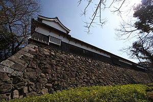
The inner castle of Fukuoka Castle is clearly defined by mounds and moats from the outer castle and the extramural areas. Most of the mounds are well preserved today and they still show the defense capability they offered.The height of the mound of the inner castle is about 8 meters (26 ft) along the Ohori Moat (Big Moat), 12 metres (39 ft) on the east side, 17 metres (56 ft) at the southeast corner of the mizunote, and 16 metres (53 ft) to the west of the hon-maru above sea level. On the north side, although most of the mound is damaged, it can be inferred that it was about 10 metres above sea level, when we consider the detailed accounts of The Illustrated Map of All Fukuoka and Hakata. Except on the southern side, usually the mound of the inner castle was characterized by the koshimaki-sekirui or mizutataki-ishigaki (a revetment constructed at the lower part of the mound), some of which still can be seen now. In addition to that, around the gates were strengthened stone walls, which are 10 metres (33 ft) high.
In Keicho 20 (1615), the mound was planted with pine trees that acted as shitomi-uemono (a visual barrier), prevented landslides, and served as windbreaks, as flaming torches, as building materials, and as emergency food. On the western and eastern sides, the mound lines have many ori (cremaillere, a front or face with receding steps, which consists of short and long branches) which permit flanking fire. The byobu-ori (tenaille lines, the trace of which is formed by making the alternate angles salient and re-entering), which can be seen from the south of the inner castle to the area to the east of the inner castle, is enormous. In general, byobu-ori has been shown to resemble the defensive lines of western fortifications. Thus it bears eloquent witness to the depth of the foresight of Kuroda Josui.
The moats of Fukuoka Castle were very wide when they are compared with the castles of other tozama-daimyos (feudal lords who did not become retainers of the Tokugawa until after the decisive victory of Tokugawa at the battle of Sekigahara in 1600). It is about 115 metres (377 ft) wide on the southeast, and on the south, where there are high mounds on both sides of the moat, it is about 45 metres (148 ft), while on the north of the castle, it is about 70 metres (230 ft) wide on an average. The Ohori Moat (Big Moat) has a width of about 600 metres (1969 ft) even after the construction of the Odote Causeway on the west of the Ohori Moat. The single, wide moat surrounding the inner castle is one of the features of this castle and only in few other castles built in the modern period can such an example be seen. The moat was originally more than 3 ken (5.9 metres in Chikuzen) deep at the Ohori Moat, and as for the other moats, more than 1 ken (2.0 metres in Chikuzen) deep at both sides and more than 3 ken deep in the middle of the moat.
By the mid-17th century, the Ohori Moat, a moat, formed by reclaiming and dredging a large cove at the time of castle construction, was filled with sediment and the Torikai area was drained and turned into grassy land. Accordingly, during the period of Empo (1673-1689), the area that was turned into land was developed into rice fields, and the Odote Causeway was built along the shorelines. At the same time, the Komo River was modified to flow on the west of the Odote Causeway so that the silt in the flows would be carried to the sea by the river. After these works, the dimensions of the Ohori Moat were reduced; the surface of the water was still more than twice as large as the present Ohori, though.
Outer Castle
An outer castle (outer castle) is a kuruwa that includes the castle town comprising samurai quarters, commoners' dwellings and temples. This kuruwa is clearly demarcated by defensive lines which consisted of moats, mound lines and gates, which separated it from the areas outside the castle. Various writers of old texts differ with regard to the exterior boundaries of the outer castle of Fukuoka Castle; some indicate a smaller area, and some indicate a larger area, but when we consider the viewpoint of the science of fortifications, it can be said that the Naka River, the Hizen Moat (present-day Tenjin 1-2 chome), the Naka Moat (present-day Daimyo 1-2 chome), the inner castle, the Tojin-machi-guchi Moat (present-day, Kuromon-gawa-dori Street), and the sea define the boundaries of the outer castle of Fukuoka Castle. The outer castle of Fukuoka Castle measures no less than about 3 km (1.9 mi) from east to west.The east side of the outer castle along the Naka River was fortified by stone walls which were about 10 metres (33 ft) high and more than 700 metres (2297 ft) long. At the midpoint of the stone walls, at the entrance from the Nakajima-nishi Bridge, was the Higashi-toriire Gate. The Higashi-toriire Gate was composed of the Kita-mon (the North Gatehouse), the Minami-mon (the South Gatehouse), and a yagura. (A gateway structure where a masugata gateway has two gatehouses facing each other, or where a yagura is placed facing the front of a masugata-gate forecourt is unique.) This grand gateway and the stone walls of the newly built capital of Chikuzen looked down on and strongly dominated the city of Hakata, which had a very long history as a mercantile city. An old book indicates that there was a Catholic church by the gate, within the walls. This may be the church built in memory of Kuroda Josui, which is mentioned in an annual report of the Jesuit Missionary, Japan.
The southern side of the outer castle was demarcated by the inner castle and two linear moats along with mound lines, the total length of which was 1,200 metres (3937 ft). There were three gates along the mound lines. These were called the Akasaka Gate, the Yakui Gate, and the Kazuma Gate (Haruyoshi Gate), respectively from west to east. The moat between the Akasaka Gate Entranceway and the Yakui Gate Entranceway was called the Hizen Moat (Saga Moat), because it was excavated with the help of Nabeshima Naoshige, who then was the lord of the Hizen Province. The Naka Moat was about 60-110 metres (197–361 ft.) wide, and the Hizen Moat was about 60-80 metres (197–263 ft.) wide. Both of these moats are considerably wider than the moats surrounding outer castles in most of the other Japanese Castles. The Chronicle of Lord Naoshige says that Kuroda Nagamasa sent laborers from Chikuzen to hizen to excavate the moat on the east of the North Gate Entranceway of Saga Castle in return for the Hizen Moat construction. The moat excavated by help of Nagamasa was called the Chikuzen Moat.
On the west side of the outer castle, there was the Tojin-machi-kuchi Moat (Yana Moat) which was about 17-35 metres (56–115 ft.) wide. Along the eastern side of this moat, there was the Matsu-dote (Pine Mound), while along the Ohori Moat continuing from the south end of the Matsu-dote, there was the Sugi-dote (Cedar Mound). On the Matsu-dote defensive line there was a single storey gate, the Kuro Gate, which, unlike the other gates of the outer castle, was not a masugata-gate. There was a weir at the north end of the moat, and fish were kept in water taken in from the sea.
In 1863, two major batteries and seven minor batteries were built along the shore lines of the outer castle, as well as other batteries around Hakata Bay due to threat of foreign invasion.
Defensive Elements outside Castle
Defensive elements can also be seen in the areas outside the castle. To the east of the outer castle, Hakata had already been fortified when the castle construction began. The defensive lines of this mercantile city probably appeared during the time of the Mongolian Invasions in the late 13th century, when a series of walls to thwart the invaders were constructed. In the 16th century, amid the age of civil wars, Hakata was fortified in full-scale by diverting the course of the Hie (Mikasa) River to the east of Hakata, and excavating moats on the south. After the construction of Fukuoka Castle, Hakata seems to have been designated as a demaru (a detached work, placed in front of a gate to cover it) defending the Higashi-toriire Gate together with Nakajima (a man-made island on the estuary of the Naka River). On the east of Hakata, there was the Ishido Entranceway and Gate, and on the south, the Tsujinodo Entranceway and Gate. Although these gates were located outside the outer castle of Fukuoka Castle, they were still designated as castle gates.The Yakui River, which was to the south of the outer castle, not only made up a defensive line itself, but also played an important role in preventing the moat around the inner castle, the Naka Moat and the Hizen Moat, from accumulating with the silt which flowed from the heights of the hills on the south of the inner castle. In Empo 6 (1678), a bridge that connected the Haruyoshi Town and the Kazuma Gate Entranceway was newly built. It was laid obliquely so that enemies could not attack the gate directly. To the west of the castle, there were the Komo (Myoan-ji) River and the Hii (Tajima) River, which served as defensive barriers.
Castle Town
In Japanese castles, defensive aspects are seen even in the castle towns; among them, temple placement at strategic points and street design are the most notable examples. In and around Fukuoka Castle, several Buddhist temples were placed at strategic points. This was probably because temple buildings could be used as barracks, temple courtyards as assembling places, and tomb stones from temple cemeteries could be used to build stone walls. Even after the completion of Fukuoka Castle, temples were still moved to strategic points, and in consequence, the castle was fortified by degrees.In the castle town, many streets were planned to be T-shaped or L-shaped, and the streets that led to the Higashi-toriire Gate and to the Kuro Gate were curved. This planning, which is typical of city planning in castle towns of the Edo Period (1603-1868), weakened the enemy's psychological and strategic ability to attack while at the same time it enabled temporary defensive lines to be constructed more easily. The layout of the streets made the modern city planning difficult, and the Fukuokans are still having problems driving the severely angled streets which followed the street design of the castle town. At the same time, however, it is one of the vestiges of Fukuoka Castle, which reminds the people that they are living in the city which was developed out of this well-fortified Fukuoka Castle.
Aftermath
Soon after the Meiji Restoration in 1868, the castle ended its history as the residence of the lords. The O-shita-no-yashiki Residence was then used as the government center of Fukuoka Prefecture, a new regional administrative unit which adopted the name of the castle. In Meiji 9 (1876) the government centre was moved to the southeastern area of what was the outer castle of Fukuoka Castle, and the castle was then used as a military complex through the year 1945, when the Pacific War ended, and the site began to be used by American occupation forces.By the time the site of the inner castle was designated a national historical site in 1957, most of the castle structures in the inner castle were decayed, demolished, and burnt except the following seven structures, which survived:
- Tamon Yagura (Minami-no-maru Nishi-hira-yagura)--Located on the top of the western wall of the Minami-no-maru.
- Shimo-no-hashi Gate—Located at the Shimo-no-hashi Gateway; Second floor of the structure removed.
- (Go-) Hon-maru Omote-(go-)mon (Main Gate of the Hon-maru)--Located on the north of the hon-maru; Moved to Sofuku-ji Temple.
- Hanami Yagura (Cherry-blossom-viewing Yagura)--Located in the southwestern corner of the inner castle; Moved to Sofuku-ji Temple; Being returned to its original location.
- Shiomi Yagura (Sea-water-watching Yagura)--Located in the northwestern corner of the inner castle; Moved to Sofuku-ji Temple; Being returned to its original location. (This structure has long been believed to be the Tsukimi Yagura.)
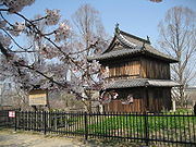
- Kinen Yagura (Prayer Yagura)--Located on the northeastern corner of the hon-maru; Moved to Taishō-ji Temple in the present-day city of Kitakyushu and returned to its original location. (The aftermath of this structure is not quite certain, because the exterior of the structure and some documents including an old photograph contradict each other.)
- Inosuke Yagura or Ko-tokiuchi Yagura (Former Clock Yagura)--Located on the western wall of the hon-maru; Moved to the Kuroda family's detached residence located to the north of the inner castle, then to the Shimo-no-hashi Gateway. (This structure has long been believed to be the Shiomi Yagura.)
The stone walls in the inner castle, however, are fairly well preserved except for the following:
- The stone wall on the south of the Higashi-Ni-no-maru.
- The stone walls around the Matsunoki-zaka Gateway.
- The stone walls around the Oimawashi Gateway.
- Some parts of the revetment on both sides of the moats.
The mound lines are also well preserved today although many parts of the moats are reclaimed.
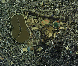
The inner castle site is now used as Maizuru (Dancing Crane) Park and Ohori Park, places of recreation and relaxation for the Fukuokan citizens. These parks include, an athletic stadium, other sports facilities, flower gardens, Fukuoka City Museum of Art, Fukuoka District and High Courts, and Jonai residential quarter.
As for the outer castle, almost all the stone walls, mound lines and structures were demolished soon after the Meiji Restoration. The Hizen Moat and the Naka Moat were reclaimed and the Tojin-machiji-guchi Moat was converted into a culvert. However, a portion of the stone walls to the south of the Higashi-toriire Gate and an upper portion of the northern stone walls (bulwark) of the battery adjacent to the estuary of the Naka River still can be seen today.