

Fruitvale Oil Field
Encyclopedia

San Joaquin Valley
The San Joaquin Valley is the area of the Central Valley of California that lies south of the Sacramento – San Joaquin River Delta in Stockton...
, California, within and just northwest of the city of Bakersfield
Bakersfield, California
Bakersfield is a city near the southern end of the San Joaquin Valley in Kern County, California. It is roughly equidistant between Fresno and Los Angeles, to the north and south respectively....
, along and north of the Kern River
Kern River
The Kern River is a river in the U.S. state of California, approximately long. It drains an area of the southern Sierra Nevada mountains northeast of Bakersfield. Fed by snowmelt near Mount Whitney, the river passes through scenic canyons in the mountains and is a popular destination for...
. It is one of the few oil fields in the California Central Valley which is mostly surrounded by a heavily populated area. Discovered in 1928, and with a cumulative total recovery of more than 124 Moilbbl of oil at the end of 2006, it is 41st in size among California oil fields, and according to the California Department of Oil, Gas, and Geothermal Resources (DOGGR) its total reserve amounts to a little less than ten percent of its original oil.
Setting
The climate is arid, with hot summers and mild winters. Temperature in the summer commonly exceeds 100 °F (37.8 °C). Only about 5 to 6 inches (152.4 mm) of precipitation falls in a year, almost invariably as rain, and in the winter. Tule fog
Tule fog
Tule fog is a thick ground fog that settles in the San Joaquin Valley and Sacramento Valley areas of California's Great Central Valley. Tule fog forms during the late fall and winter after the first significant rainfall. The official time frame for tule fog to form is from November 1 to March 31...
is common during the cooler months. Drainage is to the Kern River which flows southwest through the southern part of the field towards the Buena Vista Lake Bed.
While the native vegetation in the area is mostly allscale and needlegrass
Needlegrass
The term needlegrass may refer to any of several genera of grasses, including:*Achnatherum*Aristida *Nassella*Stipa...
, most vegetation has been removed from the area of active operations, and formerly active areas have largely been converted to industrial or other urban uses. Much of the northern part of the field, no longer used for production, is covered with residential development, as is the extreme south part, south of the Kern River. In the northwestern area of the field, the Calloway Area, a decommissioned part of the field has been turned into a golf course. Riparian vegetation and associated wildlife habitats can be found along the Kern River, which crosses through the southern part of the field.
Since the oil field is in an urbanized area, it is easily accessible from all sides. California State Route 99
California State Route 99
California State Route 99 , commonly known as Highway 99 or, simply, as 99 , is a north–south state highway in the U.S. state of California, stretching almost the entire length of the Central Valley...
, a freeway, runs along and through the east side of the field, and the Rosedale Highway, Route 58
California State Route 58
State Route 58 is an east-west highway across the California Coast Ranges, the southern San Joaquin Valley, the Tehachapi Mountains, which border the southern Sierra Nevada, and the Mojave Desert. It runs between its western terminus near Santa Margarita and its eastern terminus at Barstow...
runs across it from east to west. Calloway Drive runs approximately along the western boundary, and Coffee Road parallels Calloway Drive to the east, crossing through the entire field.
Geology
The Fruitvale Field is in a sedimentary basin in which the beds dip slightly to the west. The topmost sedimentary unit, the Kern River Formation, is young – of PleistocenePleistocene
The Pleistocene is the epoch from 2,588,000 to 11,700 years BP that spans the world's recent period of repeated glaciations. The name pleistocene is derived from the Greek and ....
age – and not oil-bearing. Underneath this alluvial layer, which is over 3000 feet (914.4 m) thick, and over millions of years, oil has collected in a series of structural traps, typically where an oil-bearing unit is topped by an impermeable one, and blocked up-dip by another impermeable structure placed there by faulting. The most productive geologic formations, from top to bottom, include the Pliocene
Pliocene
The Pliocene Epoch is the period in the geologic timescale that extends from 5.332 million to 2.588 million years before present. It is the second and youngest epoch of the Neogene Period in the Cenozoic Era. The Pliocene follows the Miocene Epoch and is followed by the Pleistocene Epoch...
Etchegoin Formation, Pliocene-Miocene
Miocene
The Miocene is a geological epoch of the Neogene Period and extends from about . The Miocene was named by Sir Charles Lyell. Its name comes from the Greek words and and means "less recent" because it has 18% fewer modern sea invertebrates than the Pliocene. The Miocene follows the Oligocene...
Chanac Formation, the Miocene 42-O Sand, and the Miocene Santa Margarita Formation. Many of these formations are productive oil-bearing units elsewhere in the Central Valley, for their geographic coverage is wide, and many structural and stratigraphic trap types exist throughout the province.
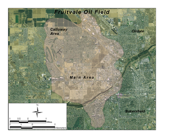
The field is divided conventionally into two significant areas: the large Main Area on the east and south, and the much smaller Calloway Area on the northwest. At the west edge of the field is the small and abandoned Greenacres Area, which was marginally productive, between 1953 and 1969.
A total of five oil pools are distinguished within the Main Area. In order of discovery, they are the Mason-Parker, Martin, and Kernco (all February 1928), Santa Margarita (December 1929), and Fairhaven (March 1936). Oil is found at depths ranging from 3,000 to 4500 feet (1,371.6 m). In the Calloway Area, two pools are identified but production data is commingled; they are named for their petroleum-bearing unit, the 42-0/42-7 Sand. This area was not discovered until 1957.
Signal Oil & Gas Co. drilled the deepest well in the field, reaching a depth of 11577 feet (3,528.7 m), and encountering the granitic basement rocks, probably of Jurassic
Jurassic
The Jurassic is a geologic period and system that extends from about Mya to Mya, that is, from the end of the Triassic to the beginning of the Cretaceous. The Jurassic constitutes the middle period of the Mesozoic era, also known as the age of reptiles. The start of the period is marked by...
age.
History, production and operations
The first well drilled in the area to find oil was by Pacific Eastern Production Company (later Gulf Oil) which reached oil in February 1928, and attained a total initial depth of 3849 feet (1,173.2 m). A few months after completion, the same well was recompleted to a depth of 6191 feet (1,887 m); however, nothing significantly more productive was found at this depth.Several enhanced recovery techniques have been used in the Fruitvale Field. In 1972, operators began waterflooding, thereby attempting to push the heavy crude to production wells, increasing the rate of extraction; in 1976, they began using cyclic steam flooding, a generally more effective technique for heavy oil, as the heat considerably reduces the oil's viscosity, helping it to flow. Fireflooding, an enhanced recovery technology in which flammable units deep underground are ignited—in this case, a 15 feet (4.6 m) thick section of oil sand—began in 1980 in the portion of the field operated by Gulf. Engineers at the time believed that up to 400 million further barrels of oil could be recovered from the field, oil which could be made to flow due to the intense heat generated by this process.
In 2008, well operators on the field included none of the major oil companies. The largest operators were independents such as Summit Energy, Big West of California, San Joaquin Facilities Management, E & B Natural Resources, Sunray Petroleum, Black Gold Oil Co., and others. A total of 301 wells remained in production, and 65 were used for injection of various kinds (including steam and wastewater).
The most productive year for the field as a whole was 1954, during which 3587093 barrels (570,302.2 m³) were extracted. Production has generally declined since, although it leveled off around 1986, with approximately 400,000 to 450000 barrels (71,544.3 m³) pumped each year since then.