

Frideswide Square
Encyclopedia
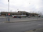
Frideswide Square is a square
Town square
A town square is an open public space commonly found in the heart of a traditional town used for community gatherings. Other names for town square are civic center, city square, urban square, market square, public square, and town green.Most town squares are hardscapes suitable for open markets,...
to the west of central Oxford
Oxford
The city of Oxford is the county town of Oxfordshire, England. The city, made prominent by its medieval university, has a population of just under 165,000, with 153,900 living within the district boundary. It lies about 50 miles north-west of London. The rivers Cherwell and Thames run through...
, England
England
England is a country that is part of the United Kingdom. It shares land borders with Scotland to the north and Wales to the west; the Irish Sea is to the north west, the Celtic Sea to the south west, with the North Sea to the east and the English Channel to the south separating it from continental...
. The square is named after the patron saint of Oxford, St Frideswide.
The "square" is actually triangular in shape. Immediately to the north, the modern Saïd Business School
Saïd Business School
Saïd Business School is the business school of the University of Oxford in England, located on the north side of Frideswide Square on the former site of Oxford Rewley Road railway station. It is the University's centre of learning for graduate and undergraduate students in business, management...
of Oxford University dominates the square, established in 1996 on the site of the former Oxford Rewley Road railway station
Oxford Rewley Road railway station
Oxford Rewley Road railway station was a railway station serving the city of Oxford, England, located immediately to the north of what is now Frideswide Square on the site of the Saïd Business School. It was the terminus of the Buckinghamshire Railway, which was worked, and later absorbed, by the...
. To the east are Hythe Bridge Street
Hythe Bridge Street
Hythe Bridge Street is in the west of central Oxford, England, forming part of the A4144 road.- Location :The street links Frideswide Square and then Botley Road to the east and Worcester Street at the western end leading north, at the junction with George Street...
(A4144) and Park End Street
Park End Street
Park End Street is a street in central Oxford, England, to the west of the centre of the city, close to the railway station at its western end.-Location:...
, both leading into central Oxford. Between them is the Royal Oxford Hotel. To the south, Hollybush Row and then Oxpens Road
Oxpens Road
Oxpens Road is a road in central Oxford, England, linking west and south Oxford. It is named after the marshy area of Oxpens, next to one of the branches of the River Thames in Oxford.- Locale :...
(A4144 road) act as an inner ring road leading to Abingdon Road
Abingdon Road
Abingdon Road is the main arterial road to the south of the city of Oxford, England. The road passes through the suburbs of Grandpont and New Hinksey...
, the main arterial road south out of the city. On the corner with Hollybush Row is the old Frank Cooper's
Frank Cooper's
Frank Cooper's is a UK brand of marmalades and jams owned by Premier Foods. Frank Cooper's is known primarily for its "Oxford" Marmalade and holds a Royal Warrant.-Oxford High Street:...
jam factory. To the west, Botley Road
Botley Road
Botley Road is the main arterial road into Oxford, England from the west. It stretches between Botley, on the Oxford Ring Road to the west of the city, and Frideswide Square at the junction with Oxford railway station, close to central Oxford....
(A420 road
A420 road
The A420 is a road between Bristol and Oxford in England. Between Swindon and Oxford it is a primary route.-Present route:Since the opening of the M4 motorway, the road is in two sections. The first section begins on Old Market Street near the centre of Bristol, it passes through Kingswood before...
) leads out of the city centre, under a railway bridge just south of the main Oxford railway station
Oxford railway station
Oxford railway station is a mainline railway station serving the city of Oxford, England. It is about west of the city centre, northwest of Frideswide Square and the eastern end of Botley Road, and on the line linking with . It is also on the line for trains between and Hereford via...
, situated to the northwest.
The square is a major traffic hub in Oxford and is often a bottleneck to traffic flow. Many buses stop on the south side of the square.
There are plans to transform the square from a congested area to a more attractive public space.
External links
- Frideswide Square, FlickrFlickrFlickr is an image hosting and video hosting website, web services suite, and online community that was created by Ludicorp in 2004 and acquired by Yahoo! in 2005. In addition to being a popular website for users to share and embed personal photographs, the service is widely used by bloggers to...