

Fortescue River
Encyclopedia
The Fortescue River is an ephemeral
river
in the Pilbara region of Western Australia
. It is the third longest river in the state.
The river rises near Deadman Hill in the Ophthalmia Range
about 30 km South of Newman
. The river flows in a Northerly direction parallel with the Great Northern Highway
until it crosses the highway just South of the Marble Bar
turn-off. The river then runs north west then westerly crossing the Great Northern Highway
again North of the Auski Roadhouse. The river continues to head west crossing Highway 1 at the Fortescue Roadhouse (21°17′44.32"S 116°08′17.52"E) and turns until discharging into the Indian Ocean
at Mardie Station
about 40 km South West of Dampier
The river was named in 1861 during an expedition by the explorer and surveyor Francis Thomas Gregory
who named it after CS Fortescue the Under Secretary of State for the colonies.
that include: Western Creek, Warrawanda Creek, Shovelanna Creek, Kalgan Creek, Fortescue River South, Cowcumba Creek, Macklin Creek and Tanga Tanga Creek.
During Cyclone
Joan in 1975 many of these tributaries also flooded. Weeli Wolli Creek and Weelumurra Creek both overflowed and caused flood
s and washaways on the Hamersley Iron and Mount Newman railway lines.
The river flows through a number of permanent water pools on the latter part of its journey including; Tarda Pool, Mungowarra Pool, Crossing Pool and Deep Reach Pool.
and the northern side of the Hamersley Range
making use of the through between the two. The valley plains are composed of earthy clays with some cracking clays, loams and hard red soils.
Water is stored at Opthalmia Dam which holds a total volume of 32,000ML, and a total of 6,290 ML/year are drawn from the surface water for use in the town of Newman
.
 The catchment area at the headwaters of the river is particularly flat and marsh
y where the Western Creek, Warrawanda Creek and Fortescue River converge, the river then flow through a poorly defined channel as far as Gregory Gorge when the river starts to form a well defined channel
and flows through a number of pools before reaching the estuarine area.
The 960 km2 Fortescue Marshes (22°26′44"S 119°26′38"E} have been identified by BirdLife International
as an Important Bird Area
(IBA) because, when the area is flooded it supports up to 270,000 waterbirds, including over 1% of the world populations of 14 species. The site is also the location for one of the only two records made since 1990 of the critically endangered
Night Parrot
.
area. The estuary is mostly unmodified, and functions primarily as a result of river energy. The delta formed by the river is tide
dominated.
The estuary covers a total surface area of 23.3 square kilometres (9 sq mi)
The majority of the estuarine area is made up of salt marsh
and intertidal flats. A colony of mangrove
s use the estuary as habitat and occupy an area of 1.2 square kilometre (0.463322590311042 sq mi). Large female Barramundi
are known to inhabit the estuary.
Ephemeral
Ephemeral things are transitory, existing only briefly. Typically the term is used to describe objects found in nature, although it can describe a wide range of things....
river
River
A river is a natural watercourse, usually freshwater, flowing towards an ocean, a lake, a sea, or another river. In a few cases, a river simply flows into the ground or dries up completely before reaching another body of water. Small rivers may also be called by several other names, including...
in the Pilbara region of Western Australia
Western Australia
Western Australia is a state of Australia, occupying the entire western third of the Australian continent. It is bounded by the Indian Ocean to the north and west, the Great Australian Bight and Indian Ocean to the south, the Northern Territory to the north-east and South Australia to the south-east...
. It is the third longest river in the state.
The river rises near Deadman Hill in the Ophthalmia Range
Ophthalmia Range
Ophthalmia Range is a range in the Pilbara region of Western Australia.The range is located approximately North of Perth and the nearest town is Newman which is found approximately South of the range in the Hamersley Range....
about 30 km South of Newman
Newman, Western Australia
Newman, located about 1186 km north of Perth and 9 km north of the Tropic of Capricorn, is a town in the Pilbara region. It can be reached by the Great Northern Highway...
. The river flows in a Northerly direction parallel with the Great Northern Highway
Great Northern Highway
The Great Northern Highway is a generally north-south Western Australian highway which links the state's capital Perth with its most northern port, Wyndham. It is in length, with being National Highway...
until it crosses the highway just South of the Marble Bar
Marble Bar, Western Australia
-North Pole:An ironically named locality nearby is known as North Pole , no doubt for its heat. It is the location of rock formations considered to have evidence that puts the origin of life on earth back to 3,400–3,500 mya, due to stromatolites in particular rock sequences...
turn-off. The river then runs north west then westerly crossing the Great Northern Highway
Great Northern Highway
The Great Northern Highway is a generally north-south Western Australian highway which links the state's capital Perth with its most northern port, Wyndham. It is in length, with being National Highway...
again North of the Auski Roadhouse. The river continues to head west crossing Highway 1 at the Fortescue Roadhouse (21°17′44.32"S 116°08′17.52"E) and turns until discharging into the Indian Ocean
Indian Ocean
The Indian Ocean is the third largest of the world's oceanic divisions, covering approximately 20% of the water on the Earth's surface. It is bounded on the north by the Indian Subcontinent and Arabian Peninsula ; on the west by eastern Africa; on the east by Indochina, the Sunda Islands, and...
at Mardie Station
Mardie Station
Mardie Station is a pastoral lease and sheep then cattle station thst was established in 1866 in the Pilbara Region of Western Australia near the mouth of the Fortescue River. The original pastoral lease was taken by Simpson and MacIntoch who worked for the Denison Plains Pastoral Company...
about 40 km South West of Dampier
Dampier, Western Australia
Dampier is a major industrial port in the north-west of Western Australia. The Dampier Port is part of the Dampier Archipelago. The port services petrochemical, salt, iron ore and natural gas export industries. Rio Tinto exports large volumes of iron ore through the port, and in September 2010...
The river was named in 1861 during an expedition by the explorer and surveyor Francis Thomas Gregory
Francis Thomas Gregory
Francis Thomas Gregory was an English-born Australian explorer and politician.-Biography:Gregory was born at Farnsfield, Nottinghamshire, England, and was the younger brother of the explorer Augustus Gregory...
who named it after CS Fortescue the Under Secretary of State for the colonies.
Tributaries
The river is known to have 24 tributariesTributary
A tributary or affluent is a stream or river that flows into a main stem river or a lake. A tributary does not flow directly into a sea or ocean...
that include: Western Creek, Warrawanda Creek, Shovelanna Creek, Kalgan Creek, Fortescue River South, Cowcumba Creek, Macklin Creek and Tanga Tanga Creek.
During Cyclone
Cyclone
In meteorology, a cyclone is an area of closed, circular fluid motion rotating in the same direction as the Earth. This is usually characterized by inward spiraling winds that rotate anticlockwise in the Northern Hemisphere and clockwise in the Southern Hemisphere of the Earth. Most large-scale...
Joan in 1975 many of these tributaries also flooded. Weeli Wolli Creek and Weelumurra Creek both overflowed and caused flood
Flood
A flood is an overflow of an expanse of water that submerges land. The EU Floods directive defines a flood as a temporary covering by water of land not normally covered by water...
s and washaways on the Hamersley Iron and Mount Newman railway lines.
The river flows through a number of permanent water pools on the latter part of its journey including; Tarda Pool, Mungowarra Pool, Crossing Pool and Deep Reach Pool.
Catchment
The Fortescue Catchment area drains from the southern side of the Chichester PlateauChichester Range
The Chichester Range is a range in the Pilbara region of Western Australia.The range rises abruptly from the coastal plain and is composed of rolling hills, escarpments, jagged peaks, gorges and winding tree-lined watercourses....
and the northern side of the Hamersley Range
Hamersley Range
The Hamersley Ranges is a mountainous region of the Pilbara, Western Australia. The range runs from the Fortescue River in the northeast, 460 km south. The range contains Western Australia's highest point, Mount Meharry, which reaches approximately AHD. There are many extensively-eroded...
making use of the through between the two. The valley plains are composed of earthy clays with some cracking clays, loams and hard red soils.
Water is stored at Opthalmia Dam which holds a total volume of 32,000ML, and a total of 6,290 ML/year are drawn from the surface water for use in the town of Newman
Newman, Western Australia
Newman, located about 1186 km north of Perth and 9 km north of the Tropic of Capricorn, is a town in the Pilbara region. It can be reached by the Great Northern Highway...
.
Fortescue Marshes
Marsh
In geography, a marsh, or morass, is a type of wetland that is subject to frequent or continuous flood. Typically the water is shallow and features grasses, rushes, reeds, typhas, sedges, other herbaceous plants, and moss....
y where the Western Creek, Warrawanda Creek and Fortescue River converge, the river then flow through a poorly defined channel as far as Gregory Gorge when the river starts to form a well defined channel
Channel (geography)
In physical geography, a channel is the physical confine of a river, slough or ocean strait consisting of a bed and banks.A channel is also the natural or human-made deeper course through a reef, sand bar, bay, or any shallow body of water...
and flows through a number of pools before reaching the estuarine area.
The 960 km2 Fortescue Marshes (22°26′44"S 119°26′38"E} have been identified by BirdLife International
BirdLife International
BirdLife International is a global Partnership of conservation organisations that strives to conserve birds, their habitats and global biodiversity, working with people towards sustainability in the use of natural resources...
as an Important Bird Area
Important Bird Area
An Important Bird Area is an area recognized as being globally important habitat for the conservation of bird populations. Currently there are about 10,000 IBAs worldwide. The program was developed and sites are identified by BirdLife International...
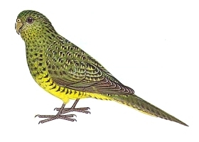
(IBA) because, when the area is flooded it supports up to 270,000 waterbirds, including over 1% of the world populations of 14 species. The site is also the location for one of the only two records made since 1990 of the critically endangered
Critically endangered
Version 2010.3 of the IUCN Red List of Threatened Species identified 3744 Critically Endangered species, subspecies and varieties, stocks and subpopulations.Critically Endangered by kingdom:*1993 Animalia*2 Fungi*1745 Plantae*4 Protista-References:...
Night Parrot
Night Parrot
The Night Parrot is a small broad-tailed parrot endemic to the continent of Australia. The species was originally placed within its own genus , but most authors now prefer to place it within the genus Pezoporus together with the two ground parrots.No known sightings of the bird were made between...
.
Estuary
The mouth of the river is a large estuarineEstuary
An estuary is a partly enclosed coastal body of water with one or more rivers or streams flowing into it, and with a free connection to the open sea....
area. The estuary is mostly unmodified, and functions primarily as a result of river energy. The delta formed by the river is tide
Tide
Tides are the rise and fall of sea levels caused by the combined effects of the gravitational forces exerted by the moon and the sun and the rotation of the Earth....
dominated.
The estuary covers a total surface area of 23.3 square kilometres (9 sq mi)
The majority of the estuarine area is made up of salt marsh
Salt marsh
A salt marsh is an environment in the upper coastal intertidal zone between land and salt water or brackish water, it is dominated by dense stands of halophytic plants such as herbs, grasses, or low shrubs. These plants are terrestrial in origin and are essential to the stability of the salt marsh...
and intertidal flats. A colony of mangrove
Mangrove
Mangroves are various kinds of trees up to medium height and shrubs that grow in saline coastal sediment habitats in the tropics and subtropics – mainly between latitudes N and S...
s use the estuary as habitat and occupy an area of 1.2 square kilometre (0.463322590311042 sq mi). Large female Barramundi
Barramundi
The Barramundi , also known as Asian Seabass, is a species of catadromous fish in family Latidae of order Perciformes. The native species is widely distributed in the Indo-West Pacific region from the Persian Gulf, through Southeast Asia to Papua New Guinea and Northern Australia. Known in Thai...
are known to inhabit the estuary.