

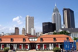
Fort Conde
Encyclopedia
- For the fort in France, see Fort de Condé-sur-AisneFort de Condé-sur-AisneThe Fort de Condé, or Fort Pille, is a fortification of the Séré de Rivières system, built in France between 1877 and 1883 to defend the area between Soissons and Laon. It is located on the heights of the confluence of the Aisne and the Vesle near the communes of Condé-sur-Aisne and Chivres-Val...
.
Fort Conde, located in Mobile, Alabama
Mobile, Alabama
Mobile is the third most populous city in the Southern US state of Alabama and is the county seat of Mobile County. It is located on the Mobile River and the central Gulf Coast of the United States. The population within the city limits was 195,111 during the 2010 census. It is the largest...
, is a reconstruction, at 4/5 scale, as a third of the original 1720s French Fort Condé at the site. The original fort was also known as Fort Carlota (under Spanish
Spain
Spain , officially the Kingdom of Spain languages]] under the European Charter for Regional or Minority Languages. In each of these, Spain's official name is as follows:;;;;;;), is a country and member state of the European Union located in southwestern Europe on the Iberian Peninsula...
rule) and also Fort Charlotte (under British
United Kingdom
The United Kingdom of Great Britain and Northern IrelandIn the United Kingdom and Dependencies, other languages have been officially recognised as legitimate autochthonous languages under the European Charter for Regional or Minority Languages...
or American rule).
The fort is located at 150 South Royal Street.
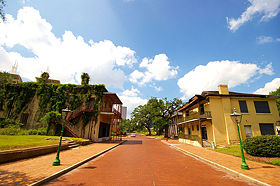
The current Fort Conde, spanning almost 1/3 of the original fort, was recreated at 4/5-scale on the site. The new Fort Conde was opened on July 4, 1976, as part of Mobile’s celebration of the United States bicentennial.
Admission to Fort Conde is free.
History
MobileMobile, Alabama
Mobile is the third most populous city in the Southern US state of Alabama and is the county seat of Mobile County. It is located on the Mobile River and the central Gulf Coast of the United States. The population within the city limits was 195,111 during the 2010 census. It is the largest...
was originally founded by Jean-Baptiste Le Moyne de Bienville in 1702 as Fort Louis de la Mobile at 27-Mile Bluff up river (27 miles [43 km] from the mouth).
After the Mobile River
Mobile River
The Mobile River is located in southern Alabama in the United States. Formed out of the confluence of the Tombigbee and Alabama rivers, the approximately river drains an area of of Alabama, with a watershed extending into Mississippi, Georgia, and Tennessee. Its drainage basin is the...
flooded and damaged the fort, Mobile was relocated in 1711 to the current site. A temporary wooden stockade fort was constructed, also named Fort Louis after the old fort up river. In 1723, construction of a new brick fort with a stone foundation began, renamed later as Fort Condé in honor of King Louis XIV’s brother.
Fort Condé guarded Mobile and its citizens for almost 100 years, from 1723-1820. The fort had been built by the French to defend against British or Spanish attack on the strategic location of Mobile and its Bay as a port to the Gulf of Mexico
Gulf of Mexico
The Gulf of Mexico is a partially landlocked ocean basin largely surrounded by the North American continent and the island of Cuba. It is bounded on the northeast, north and northwest by the Gulf Coast of the United States, on the southwest and south by Mexico, and on the southeast by Cuba. In...
, on the eastern most part of the French Louisiana
Louisiana (New France)
Louisiana or French Louisiana was an administrative district of New France. Under French control from 1682–1763 and 1800–03, the area was named in honor of Louis XIV, by French explorer René-Robert Cavelier, Sieur de la Salle...
colony. The strategic importance of Mobile and Fort Condé was significant: the fort protected access into the strategic region between the Mississippi River and the Atlantic colonies along the Alabama River
Alabama River
The Alabama River, in the U.S. state of Alabama, is formed by the Tallapoosa and Coosa rivers, which unite about north of Montgomery.The river flows west to Selma, then southwest until, about from Mobile, it unites with the Tombigbee, forming the Mobile and Tensaw rivers, which discharge into...
and Tombigbee River
Tombigbee River
The Tombigbee River is a tributary of the Mobile River, approximately 200 mi long, in the U.S. states of Mississippi and Alabama. It is one of two major rivers, along with the Alabama River, that unite to form the short Mobile River before it empties into Mobile Bay on the Gulf of Mexico...
.
Fort Condé and its surrounding buildings covered about 11 acres (44,515.5 m²) of land. It was constructed of local brick and stone, with earthen dirt walls, plus cedar wood
Cedar wood
Cedar wood comes from several different trees that grow in different parts of the world, and may have different uses.* California incense-cedar, from Calocedrus decurrens, is the primary type of wood used for making pencils...
. A crew of 20 black slaves and 5 white workmen performed original work on the fort. If the fort had been reconstructed full-size, it would cover large sections of Royal Street, Government Boulevard, Church, St. Emanuel, and Theatre Streets in downtown Mobile.
During 1763 to 1780, England was in possession of the region, and Fort Condé was renamed Fort Charlotte in honor of King George III’s wife. From 1780 to 1813, Spain
Spain
Spain , officially the Kingdom of Spain languages]] under the European Charter for Regional or Minority Languages. In each of these, Spain's official name is as follows:;;;;;;), is a country and member state of the European Union located in southwestern Europe on the Iberian Peninsula...
ruled the region, and the fort was renamed Fort Carlota. In 1813, Mobile was occupied by United States troops, and the fort was renamed again as Fort Charlotte.
In 1820, the U.S. Congress authorized sale and removal of the fort because it was no longer needed for defense. Later, city funds paid for the demolition
Demolition
Demolition is the tearing-down of buildings and other structures, the opposite of construction. Demolition contrasts with deconstruction, which involves taking a building apart while carefully preserving valuable elements for re-use....
to allow new streets built eastward towards the river and southward. By late 1823, most of the above-ground traces of Mobile’s fort were gone, leaving only underground structures.
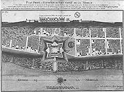
Original fort design
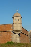
The original Fort Condé, from 1723, was shaped in the form of a seven-pointed star, with guard towers raised at the points (see map image) with significant surrounding earth works. In design, it is similar to Spanish fort Castillo de San MarcosCastillo de San Marcos
The Castillo de San Marcos site is the oldest masonry fort in the United States. It is located in the city of St. Augustine, Florida. Construction was begun in 1672 by the Spanish when Florida was a Spanish territory. During the twenty year period of British possession from 1763 until 1784, the...
in St. Augustine, Florida.
was aligned parallel to the Mobile River
Mobile River
The Mobile River is located in southern Alabama in the United States. Formed out of the confluence of the Tombigbee and Alabama rivers, the approximately river drains an area of of Alabama, with a watershed extending into Mississippi, Georgia, and Tennessee. Its drainage basin is the...
, rather than north/south, so that the fort faced somewhat northeast along an elevated bluff that was lined by "Royal Street" overlooking the marshland sloping down below.
(Even in contemporary Mobile, Royal Street is at higher elevation, with the newer streets of Water Street and Commerce Street [not on 1725 map] further down the slopes towards the Mobile River).
Some buildings within the fort compound had the French Mansard roof style, with dormer
Dormer
A dormer is a structural element of a building that protrudes from the plane of a sloping roof surface. Dormers are used, either in original construction or as later additions, to create usable space in the roof of a building by adding headroom and usually also by enabling addition of windows.Often...
windows extending from each roof (see enlarged building images below, or building profiles at top of 1725 map).
The tall chimneys at the ends of the buildings, shown in the map profile, were not used on the reconstructed Fort Condé. Also, the lengths of buildings were longer in the original fort, than represented in the 4/5 scale replica fort. The Mobile River is illustrated on the 1725 map with label "Riviere de la Mobille" as also using spelling "Mobille".
The map was drawn by Adrien de Pauger in 1725. After Jean-Baptiste Le Moyne de Bienville moved Mobile downriver in May 1711 (following the death of his brother D'Iberville in 1706), he planned the next capital city (after 1718) to be on the Mississippi River
Mississippi River
The Mississippi River is the largest river system in North America. Flowing entirely in the United States, this river rises in western Minnesota and meanders slowly southwards for to the Mississippi River Delta at the Gulf of Mexico. With its many tributaries, the Mississippi's watershed drains...
, in similar fashion to being on the Mobile River, and so Adrien de Pauger also designed the Vieux Carré
Vieux Carre
Vieux Carré may refer to:*New Orleans's French Quarter* Vieux Carré, a play by Tennessee Williams...
in New Orleans, Louisiana
New Orleans, Louisiana
New Orleans is a major United States port and the largest city and metropolitan area in the state of Louisiana. The New Orleans metropolitan area has a population of 1,235,650 as of 2009, the 46th largest in the USA. The New Orleans – Metairie – Bogalusa combined statistical area has a population...
, which was built from 1719-1722. The ships of the original French settlers, sailing to Old Biloxi in 1699, and later transfers, were staged through Dauphin Island (south of Mobile Bay
Mobile Bay
Mobile Bay is an inlet of the Gulf of Mexico, lying within the state of Alabama in the United States. Its mouth is formed by the Fort Morgan Peninsula on the eastern side and Dauphin Island, a barrier island on the western side. The Mobile River and Tensaw River empty into the northern end of the...
, which was not dredged for larger ships until many years later).
Gallery
 |
 |
|
 |
 |
|
External links
- Fort Conde - Official site at Museum of Mobile