

Forest County, Wisconsin
Encyclopedia
Forest County is a county
in the U.S. state
of Wisconsin
. As of the 2010 census, the population was 9,304. Its county seat
is Crandon
.
and the Sokaogon Chippewa Community
have reservations in Forest County.
, the county has a total area of 1046 square miles (2,709.1 km²), of which 1014 square miles (2,626.2 km²) is land and 32 square miles (82.9 km²) (3.09%) is water.
As of the census
of 2000, there were 10,024 people, 4,043 households, and 2,769 families residing in the county. The population density
was 10 people per square mile (4/km²). There were 8,322 housing units at an average density of 8 per square mile (3/km²). The racial makeup of the county was 85.86% White
, 11.30% Native American
, 1.18% Black
or African American
, 0.17% Asian
, 0.04% Pacific Islander
, 0.23% from other races
, and 1.22% from two or more races. 1.08% of the population were Hispanic
or Latino
of any race. 34.3% were of German, 11.4% Polish, 7.4% Irish
and 5.4% American
ancestry according to Census 2000. 95.5% spoke English
, 1.4% Spanish
and 1.0% Potawatomi
as their first language.
Out of the 4,043 households, 29.20% have children under the age of 18, 54.00% have a married couple
living together, 9.80% had a female householder with no husband present, and 31.50% were non-families. 28.20% of all households were made up of individuals living alone, and 13.20%, of individuals of 65 years of age or older living alone. The average household size was 2.39 and the average family size was 2.89.
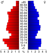
The age distribution in the county's population is as follows: 25.30% under the age of 18, 7.80% from 18 to 24, 23.90% from 25 to 44, 23.80% from 45 to 64, and 19.30% 65 years of age or older. The median age is 40 years. For every 100 females there were 100.20 males. For every 100 females age 18 and over, there were 99.00 males.
County (United States)
In the United States, a county is a geographic subdivision of a state , usually assigned some governmental authority. The term "county" is used in 48 of the 50 states; Louisiana is divided into parishes and Alaska into boroughs. Parishes and boroughs are called "county-equivalents" by the U.S...
in the U.S. state
U.S. state
A U.S. state is any one of the 50 federated states of the United States of America that share sovereignty with the federal government. Because of this shared sovereignty, an American is a citizen both of the federal entity and of his or her state of domicile. Four states use the official title of...
of Wisconsin
Wisconsin
Wisconsin is a U.S. state located in the north-central United States and is part of the Midwest. It is bordered by Minnesota to the west, Iowa to the southwest, Illinois to the south, Lake Michigan to the east, Michigan to the northeast, and Lake Superior to the north. Wisconsin's capital is...
. As of the 2010 census, the population was 9,304. Its county seat
County seat
A county seat is an administrative center, or seat of government, for a county or civil parish. The term is primarily used in the United States....
is Crandon
Crandon, Wisconsin
Crandon is a city in Forest County, Wisconsin, United States; it is in the northeastern part of the state, about north of Green Bay. The population was 1,920 at the 2010 census. It is the county seat of Forest County and is the only incorporated community in the county...
.
Indian Reservations
The Forest County Potawatomi CommunityForest County Potawatomi Community
The Forest County Potawatomi Community is a band of the Potawatomi, many of whom live on the Forest County Potawatomi Indian Reservation, most of which lies on numerous non-contiguous plots of land in southern Forest County and northern Oconto County, Wisconsin, USA. There is also a small 6.95 acre...
and the Sokaogon Chippewa Community
Sokaogon Chippewa Community
The Sokaogon Chippewa Community, or the Mole Lake Band of Lake Superior Chippewa, is a band of the Lake Superior Chippewa, many of whom reside on the Mole Lake Indian Reservation, an Indian reservation located at in Mole Lake, Wisconsin, in Forest County near Crandon.The Mole Lake Indian...
have reservations in Forest County.
Geography
According to the U.S. Census BureauUnited States Census Bureau
The United States Census Bureau is the government agency that is responsible for the United States Census. It also gathers other national demographic and economic data...
, the county has a total area of 1046 square miles (2,709.1 km²), of which 1014 square miles (2,626.2 km²) is land and 32 square miles (82.9 km²) (3.09%) is water.
Adjacent counties
- Florence CountyFlorence County, WisconsinFlorence County is a county located in the U.S. state of Wisconsin. As of 2000, the population was 5,088. Its county seat is Florence.Florence County is part of the Iron Mountain, MI–WI Micropolitan Statistical Area.-Geography:According to the U.S...
- northeast - Marinette CountyMarinette County, WisconsinMarinette County is a county located in the U.S. state of Wisconsin. As of 2000, the population was 43,384. Its county seat is Marinette.Marinette County is part of the Marinette, WI–MI Micropolitan Statistical Area.-Geography:According to the U.S...
- east - Oconto CountyOconto County, WisconsinOconto County is a county in the U.S. state of Wisconsin. As of 2000, the population was 35,634. Its county seat is Oconto.Oconto County is part of the Green Bay Metropolitan Statistical Area. It was established in 1851.-Geography:According to the U.S...
- southeast - Langlade CountyLanglade County, WisconsinLanglade County is a county located in the U.S. state of Wisconsin. As of 2000, the population was 20,740. Its county seat is Antigo.-Geography:According to the U.S. Census Bureau, the county has a total area of , of which is land and is water...
- southwest - Oneida CountyOneida County, WisconsinOneida County is a county in the U.S. state of Wisconsin. As of 2000, the population was 36,776. Its county seat is Rhinelander.-Geography:According to the U.S. Census Bureau, the county has a total area of 1,236 square miles , of which 1,124 square miles is land and 111 square...
- west - Vilas CountyVilas County, WisconsinVilas County is a county in the U.S. state of Wisconsin. As of 2000, the population was 21,033. Its county seat is Eagle River.-Settlement:Vilas County was set off from Oneida County on April 12, 1893 and named for William Freeman Vilas...
- northwest - Iron County, MichiganIron County, Michigan-Demographics:As of the census of 2000, there were 13,138 people, 5,748 households, and 3,615 families residing in the county. The population density was 11 people per square mile . There were 8,772 housing units at an average density of 8 per square mile...
- north
Major highways
|
 Highway 70 (Wisconsin) Highway 70 (Wisconsin)Highway 70 (Wisconsin) State Trunk Highway 70 is a state highway in the U.S. state of Wisconsin. It runs east–west in northern Wisconsin from a shared terminus with WIS 101 at US 2 and US 141 near Florence to a connection with Minnesota State Highway 70 at the St. Croix River west of Grantsburg in Burnett County...  Highway 52 (Wisconsin) Highway 52 (Wisconsin)Highway 52 (Wisconsin) State Trunk Highway 52 is a state highway in the U.S. state of Wisconsin. It runs east–west in northeast Wisconsin from Wabeno to Wausau.-Notes:...  Highway 101 (Wisconsin) Highway 101 (Wisconsin)Highway 101 (Wisconsin) State Trunk Highway 101 is a state highway in the U.S. state of Wisconsin. It runs south–north in northeast Wisconsin from US 8 in Armstrong Creek in eastern Forest County to Florence...  Highway 139 (Wisconsin) Highway 139 (Wisconsin)Highway 139 (Wisconsin) State Trunk Highway 139 is a state highway in the U.S. state of Wisconsin. It runs in north–south in north central Wisconsin from the Michigan State Line and its connection with M-189 at the Brule River approximately four miles north of Tipler in Forence County to a junction with US 8 near... |
 U.S. Highway 8

Demographics
As of the census
Census
A census is the procedure of systematically acquiring and recording information about the members of a given population. It is a regularly occurring and official count of a particular population. The term is used mostly in connection with national population and housing censuses; other common...
of 2000, there were 10,024 people, 4,043 households, and 2,769 families residing in the county. The population density
Population density
Population density is a measurement of population per unit area or unit volume. It is frequently applied to living organisms, and particularly to humans...
was 10 people per square mile (4/km²). There were 8,322 housing units at an average density of 8 per square mile (3/km²). The racial makeup of the county was 85.86% White
Race (United States Census)
Race and ethnicity in the United States Census, as defined by the Federal Office of Management and Budget and the United States Census Bureau, are self-identification data items in which residents choose the race or races with which they most closely identify, and indicate whether or not they are...
, 11.30% Native American
Race (United States Census)
Race and ethnicity in the United States Census, as defined by the Federal Office of Management and Budget and the United States Census Bureau, are self-identification data items in which residents choose the race or races with which they most closely identify, and indicate whether or not they are...
, 1.18% Black
Race (United States Census)
Race and ethnicity in the United States Census, as defined by the Federal Office of Management and Budget and the United States Census Bureau, are self-identification data items in which residents choose the race or races with which they most closely identify, and indicate whether or not they are...
or African American
Race (United States Census)
Race and ethnicity in the United States Census, as defined by the Federal Office of Management and Budget and the United States Census Bureau, are self-identification data items in which residents choose the race or races with which they most closely identify, and indicate whether or not they are...
, 0.17% Asian
Race (United States Census)
Race and ethnicity in the United States Census, as defined by the Federal Office of Management and Budget and the United States Census Bureau, are self-identification data items in which residents choose the race or races with which they most closely identify, and indicate whether or not they are...
, 0.04% Pacific Islander
Race (United States Census)
Race and ethnicity in the United States Census, as defined by the Federal Office of Management and Budget and the United States Census Bureau, are self-identification data items in which residents choose the race or races with which they most closely identify, and indicate whether or not they are...
, 0.23% from other races
Race (United States Census)
Race and ethnicity in the United States Census, as defined by the Federal Office of Management and Budget and the United States Census Bureau, are self-identification data items in which residents choose the race or races with which they most closely identify, and indicate whether or not they are...
, and 1.22% from two or more races. 1.08% of the population were Hispanic
Race (United States Census)
Race and ethnicity in the United States Census, as defined by the Federal Office of Management and Budget and the United States Census Bureau, are self-identification data items in which residents choose the race or races with which they most closely identify, and indicate whether or not they are...
or Latino
Race (United States Census)
Race and ethnicity in the United States Census, as defined by the Federal Office of Management and Budget and the United States Census Bureau, are self-identification data items in which residents choose the race or races with which they most closely identify, and indicate whether or not they are...
of any race. 34.3% were of German, 11.4% Polish, 7.4% Irish
Irish people
The Irish people are an ethnic group who originate in Ireland, an island in northwestern Europe. Ireland has been populated for around 9,000 years , with the Irish people's earliest ancestors recorded having legends of being descended from groups such as the Nemedians, Fomorians, Fir Bolg, Tuatha...
and 5.4% American
United States
The United States of America is a federal constitutional republic comprising fifty states and a federal district...
ancestry according to Census 2000. 95.5% spoke English
English language
English is a West Germanic language that arose in the Anglo-Saxon kingdoms of England and spread into what was to become south-east Scotland under the influence of the Anglian medieval kingdom of Northumbria...
, 1.4% Spanish
Spanish language
Spanish , also known as Castilian , is a Romance language in the Ibero-Romance group that evolved from several languages and dialects in central-northern Iberia around the 9th century and gradually spread with the expansion of the Kingdom of Castile into central and southern Iberia during the...
and 1.0% Potawatomi
Potawatomi language
Potawatomi is a Central Algonquian language and is spoken around the Great Lakes in Michigan and Wisconsin, as well as in Kansas in the United States, and in southern Ontario in Canada, 1300 Potawatomi people, all elderly...
as their first language.
Out of the 4,043 households, 29.20% have children under the age of 18, 54.00% have a married couple
Marriage
Marriage is a social union or legal contract between people that creates kinship. It is an institution in which interpersonal relationships, usually intimate and sexual, are acknowledged in a variety of ways, depending on the culture or subculture in which it is found...
living together, 9.80% had a female householder with no husband present, and 31.50% were non-families. 28.20% of all households were made up of individuals living alone, and 13.20%, of individuals of 65 years of age or older living alone. The average household size was 2.39 and the average family size was 2.89.
The age distribution in the county's population is as follows: 25.30% under the age of 18, 7.80% from 18 to 24, 23.90% from 25 to 44, 23.80% from 45 to 64, and 19.30% 65 years of age or older. The median age is 40 years. For every 100 females there were 100.20 males. For every 100 females age 18 and over, there were 99.00 males.
Towns
- AlvinAlvin, WisconsinAlvin is a town in Forest County, Wisconsin, United States. The population was 157 at the 2010 census. The unincorporated communities of Alvin and Nelma are located in the town.-Geography:...
- ArgonneArgonne, WisconsinArgonne is a town in Forest County, Wisconsin, United States. The population was 512 at the 2010 census. The census-designated place of Argonne is located in the town...
- Armstrong CreekArmstrong Creek, WisconsinArmstrong Creek is a town in Forest County, Wisconsin, United States. The population was 409 at the 2010 census. The unincorporated communities of Armstrong Creek, Bonneval, and Laona Junction are located with the town.-Geography:...
- BlackwellBlackwell, WisconsinBlackwell is a town in Forest County, Wisconsin, United States. The population was 332 at the 2010 census. The unincorporated community of Blackwell is located in the town...
- CaswellCaswell, WisconsinCaswell is a town in Forest County, Wisconsin, United States. The population was 91 at the 2010 census. The unincorporated community of Cavour is located within the town.-Geography:...
- Crandon (town)Crandon (town), WisconsinCrandon is a town in Forest County, Wisconsin, United States. The population was 650 at the 2010 census. The City of Crandon is located adjacent to the town.-Geography:...
- FreedomFreedom, Forest County, WisconsinFreedom is a town in Forest County, Wisconsin, United States. The population was 345 at the 2010 census.-Geography:According to the United States Census Bureau, the town has a total area of , of which is land and , or 5.62%, is water.-Demographics:...
- HilesHiles, Forest County, WisconsinHiles is a town in Forest County, Wisconsin, United States. The population was 311 at the 2010 census. The unincorporated communities of Atkins and Hiles are located in the town.-Geography:...
- LaonaLaona, WisconsinLaona is a town in Forest County, Wisconsin, United States. The population was 1,212 at the 2010 census. The census-designated place of Laona is located in the town...
- LincolnLincoln, Forest County, WisconsinLincoln is a town in Forest County, Wisconsin, United States. The population was 955 at the 2010 census. The ghost town of Keith was located in town.-Geography:...
- NashvilleNashville, WisconsinNashville is a town in Forest County, Wisconsin, United States. The population was 1,064 at the 2010 census. The unincorporated communities of Mole Lake, Nashville, and Woodlawn are located in the town.-Geography:...
- Popple RiverPopple River, WisconsinPopple River is a town in Forest County, Wisconsin, United States. The population was 44 at the 2010 census. The unincorporated community of Popple River is located in the town.-Geography:...
- RossRoss, WisconsinRoss is a town in Forest County, Wisconsin, United States. The population was 136 at the 2010 census. The census-designated place of Newald is located in the town...
- WabenoWabeno, WisconsinWabeno is a town in Forest County, Wisconsin, United States. The population was 1,166 at the 2010 census. The census-designated place of Wabeno and the unincorporated communities of Carter, Padus, and Soperton are located in the town.-Geography:...
Unincorporated communities
- AlvinAlvin (community), WisconsinAlvin is an unincorporated community in the town of Alvin, Forest County, Wisconsin, United States. Alvin is located on Wisconsin Highway 55 north of Crandon....
- Argonne
- Armstrong CreekArmstrong Creek (community), WisconsinArmstrong Creek is an unincorporated community in the town of Armstrong Creek, Forest County, Wisconsin, United States. Armstrong Creek is located at the junction of U.S. Route 8 and Wisconsin Highway 101 east-northeast of Crandon. Armstrong Creek has a post office with ZIP code 54103....
- AtkinsAtkins, WisconsinAtkins is an unincorporated community in the town of Hiles, Forest County, Wisconsin, United States. Atkins is located on the Canadian National Railway northwest of Crandon....
- BlackwellBlackwell (community), WisconsinBlackwell is an unincorporated community in the town of Blackwell, Forest County, Wisconsin, United States. Blackwell is east-southeast of Crandon....
- Blackwell JunctionBlackwell Junction, WisconsinBlackwell Junction is an unincorporated community in the towns of Blackwell and Laona, Forest County, Wisconsin, United States. Blackwell Junction is east-southeast of Crandon....
- BonnevalBonneval, WisconsinBonneval is an unincorporated community in the town of Armstrong Creek, Forest County, Wisconsin, United States. Bonneval is located along the Canadian National Railway east-northeast of Crandon....
- Carter
- CavourCavour, WisconsinCavour is an unincorporated community in Forest County, Wisconsin, United States. Cavour is located in the town of Caswell, east-northeast of Crandon....
- HilesHiles (community), WisconsinHiles is an unincorporated community in the town of Hiles, Forest County, Wisconsin, United States. Hiles is located on Wisconsin Highway 32 north-northwest of Crandon....
- LaonaLaona (community), WisconsinLaona is an unincorporated census-designated place in the town of Laona in Forest County, Wisconsin, United States. U.S. Route 8 travels east-west through the community and Wisconsin Highway 32 travels south and west of the community. The community park has a sign stating that the community donated...
- Laona JunctionLaona Junction, WisconsinLaona Junction is an unincorporated community in the town of Armstrong Creek in Forest County, Wisconsin, United States. U.S. Route 8 travels north-south near the community....
- Mole LakeMole Lake, WisconsinMole Lake, Wisconsin is an unincorporated census-designated place located in the town of Nashville in Forest County, Wisconsin, United States. The community is located on Wisconsin Highway 55 in the Mole Lake Indian Reservation. As of the 2010 census, its population is 435. Mole Lake has an area of...
- NashvilleNashville (community), WisconsinNashville is an unincorporated community in the town of Nashville, Forest County, Wisconsin, United States. Nashville is west-southwest of Crandon....
- NelmaNelma, WisconsinNelma is an unincorporated community in the town of Alvin, Forest County, Wisconsin, United States. Nelma is located on Wisconsin Highway 55 near the Michigan border, north of Crandon....
- PadusPadus, WisconsinPadus is an unincorporated community located in the town of Wabeno, in Forest County, Wisconsin, United States....
- Popple RiverPopple River (community), WisconsinPopple River is an unincorporated community in the town of Popple River, Forest County, Wisconsin, United States. Popple River is located on the Popple River and Wisconsin Highway 139 northeast of Crandon....
- SopertonSoperton, WisconsinSoperton is an unincorporated community located within the town of Wabeno, in Forest County, Wisconsin, United States.-Notes:...
- WabenoWabeno (community), WisconsinWabeno is an unincorporated census-designated place located within the town of Wabeno, in Forest County, Wisconsin, United States. It is located on Wisconsin Highway 32 at the eastern terminus of Wisconsin Highway 52 within the Nicolet National Forest...
- Wisconsin JunctionWisconsin Junction, WisconsinWisconsin Junction is an unincorporated community located in the town of Argonne, Forest County, Wisconsin, United States....
- WoodlawnWoodlawn, WisconsinWoodlawn is an unincorporated community in the town of Nashville, Forest County, Wisconsin, United States. Woodlawn is south-southeast of Crandon....
See also
- National Register of Historic Places listings in Forest County, Wisconsin