

Flood barrier
Encyclopedia
A flood barrier, surge barrier of storm surge barrier is a specific type of floodgate
, designed to prevent a storm surge
or spring tide from flooding the protected area behind the barrier. A surge barrier is almost always part of a larger flood protection system consisting of floodwalls, levee
s (also known as dykes) and other constructions and natural geographical features.
Surge barriers allow water to pass under normal circumstances, but when a (storm) surge is expected the barrier can be closed. The means of closing can consist of various forms of gates.
in the Netherlands
is the largest flood protection project in the world. This project consists of a number of surge barriers, the Oosterscheldekering
being the largest surge barrier in the world, 9 kilometres (5.6 mi) long. Other examples include the Maeslantkering
, Haringvlietdam and the Hartelkering
.
is the world's second largest movable flood barrier (after the Oosterscheldekering) and is located downstream of central London
. Its purpose is to prevent London from being flooded by exceptionally high tide
s and storm surges moving up from the North Sea
. It needs to be raised (closed) only during high tide; at ebb tide it can be lowered to release the water that backs up behind it.
, a storm surge funneled by the confluence of the Gulf Intracoastal Waterway
and Mississippi River Gulf Outlet levees created multiple breaches in the Industrial Canal
's concrete floodwalls, resulting in catastrophic flooding. The situation was worsened when a storm surge from Lake Ponchartrain entered the canal from the other side.
In 2009 the United States Army Corps of Engineers
started construction of an ambitious project that aims to prevent storm surges from flooding the city by 2011. The IHNC Lake Borgne Surge Barrier
on the confluence of these waterways will be the largest in the United States. The new Seabrook floodgate will prevent a storm surge from entering from Lake Ponchartrain.
The GIWW West Closure Complex
will close the Gulf Intracoastal Waterway
to protect the west side of the city. This complex is unique in that it contains the world's largest pumping station
, necessary to pump out rainwater that is discharged in the protected side of the canal during a hurricane.
is located at the mouth of the river Eider
near Tönning
on Germany’s North Sea coast. Its main purpose is protection from storm surge
s by the North Seas. It is Germany’s largest coastal protection structure.
Floodgate
Floodgates are adjustable gates used to control water flow in flood barriers, reservoir, river, stream, or levee systems. They may be designed to set spillway crest heights in dams, to adjust flow rates in sluices and canals, or they may be designed to stop water flow entirely as part of a levee or...
, designed to prevent a storm surge
Storm surge
A storm surge is an offshore rise of water associated with a low pressure weather system, typically tropical cyclones and strong extratropical cyclones. Storm surges are caused primarily by high winds pushing on the ocean's surface. The wind causes the water to pile up higher than the ordinary sea...
or spring tide from flooding the protected area behind the barrier. A surge barrier is almost always part of a larger flood protection system consisting of floodwalls, levee
Levee
A levee, levée, dike , embankment, floodbank or stopbank is an elongated naturally occurring ridge or artificially constructed fill or wall, which regulates water levels...
s (also known as dykes) and other constructions and natural geographical features.
Surge barriers allow water to pass under normal circumstances, but when a (storm) surge is expected the barrier can be closed. The means of closing can consist of various forms of gates.
Delta Works
The Delta WorksDelta Works
The Delta Works is a series of construction projects in the southwest of the Netherlands to protect a large area of land around the Rhine-Meuse-Scheldt delta from the sea. The works consist of dams, sluices, locks, dikes, levees, and storm surge barriers...
in the Netherlands
Netherlands
The Netherlands is a constituent country of the Kingdom of the Netherlands, located mainly in North-West Europe and with several islands in the Caribbean. Mainland Netherlands borders the North Sea to the north and west, Belgium to the south, and Germany to the east, and shares maritime borders...
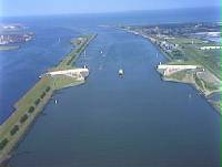
is the largest flood protection project in the world. This project consists of a number of surge barriers, the Oosterscheldekering
Oosterscheldekering
The Oosterscheldekering , between the islands Schouwen-Duiveland and Noord-Beveland, is the largest of the 13 ambitious Delta works series of dams, designed to protect the Netherlands from flooding...
being the largest surge barrier in the world, 9 kilometres (5.6 mi) long. Other examples include the Maeslantkering
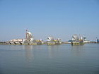
Maeslantkering
The Maeslantkering is a storm surge barrier in the Nieuwe Waterweg waterway located between the towns of Hoek van Holland and Maassluis, Netherlands, , which automatically closes when needed...
, Haringvlietdam and the Hartelkering
Hartelkering
The Hartelkering is a storm surge barrier in Spijkenisse, in the Netherlands. The barrier is part of the Delta Works and is designed to close the Hartelkanaal in case of a storm surge....
.
Thames Barrier
The Thames BarrierThames Barrier
The Thames Barrier is the world's second-largest movable flood barrier and is located downstream of central London. Its purpose is to prevent London from being flooded by exceptionally high tides and storm surges moving up from the sea...
is the world's second largest movable flood barrier (after the Oosterscheldekering) and is located downstream of central London
London
London is the capital city of :England and the :United Kingdom, the largest metropolitan area in the United Kingdom, and the largest urban zone in the European Union by most measures. Located on the River Thames, London has been a major settlement for two millennia, its history going back to its...
. Its purpose is to prevent London from being flooded by exceptionally high tide
Tide
Tides are the rise and fall of sea levels caused by the combined effects of the gravitational forces exerted by the moon and the sun and the rotation of the Earth....
s and storm surges moving up from the North Sea
North Sea
In the southwest, beyond the Straits of Dover, the North Sea becomes the English Channel connecting to the Atlantic Ocean. In the east, it connects to the Baltic Sea via the Skagerrak and Kattegat, narrow straits that separate Denmark from Norway and Sweden respectively...
. It needs to be raised (closed) only during high tide; at ebb tide it can be lowered to release the water that backs up behind it.
New Orleans
In 2005, with the approach of Hurricane KatrinaHurricane Katrina
Hurricane Katrina of the 2005 Atlantic hurricane season was a powerful Atlantic hurricane. It is the costliest natural disaster, as well as one of the five deadliest hurricanes, in the history of the United States. Among recorded Atlantic hurricanes, it was the sixth strongest overall...
, a storm surge funneled by the confluence of the Gulf Intracoastal Waterway
Gulf Intracoastal Waterway
The Gulf Intracoastal Waterway is the portion of the Intracoastal Waterway located along the Gulf Coast of the United States. It is a navigable inland waterway running approximately 1700 kilometers from Carrabelle, Florida, to Brownsville, Texas.The waterway provides a channel with a controlling...
and Mississippi River Gulf Outlet levees created multiple breaches in the Industrial Canal
Industrial Canal
The Industrial Canal is a 5.5 mile waterway in New Orleans, Louisiana, United States. The waterway's proper name, as used by the U.S. Army Corps of Engineers and on NOAA nautical charts, is Inner Harbor Navigation Canal...
's concrete floodwalls, resulting in catastrophic flooding. The situation was worsened when a storm surge from Lake Ponchartrain entered the canal from the other side.
In 2009 the United States Army Corps of Engineers
United States Army Corps of Engineers
The United States Army Corps of Engineers is a federal agency and a major Army command made up of some 38,000 civilian and military personnel, making it the world's largest public engineering, design and construction management agency...
started construction of an ambitious project that aims to prevent storm surges from flooding the city by 2011. The IHNC Lake Borgne Surge Barrier
IHNC Lake Borgne Surge Barrier
The Inner Harbor Navigation Canal Lake Borgne Surge Barrier is a storm surge barrier under construction near the confluence of and across the Gulf Intracoastal Waterway and the Mississippi River Gulf Outlet near New Orleans...
on the confluence of these waterways will be the largest in the United States. The new Seabrook floodgate will prevent a storm surge from entering from Lake Ponchartrain.
The GIWW West Closure Complex
Gulf Intracoastal Waterway West Closure Complex
The Gulf Intracoastal Waterway West Closure Complex is a part of the New Orleans Drainage System; it will consist of a navigable floodgate, a pumping station, floodwalls, sluice gates, foreshore protection, and an earthen levee...
will close the Gulf Intracoastal Waterway
Gulf Intracoastal Waterway
The Gulf Intracoastal Waterway is the portion of the Intracoastal Waterway located along the Gulf Coast of the United States. It is a navigable inland waterway running approximately 1700 kilometers from Carrabelle, Florida, to Brownsville, Texas.The waterway provides a channel with a controlling...
to protect the west side of the city. This complex is unique in that it contains the world's largest pumping station
Pumping station
Pumping stations are facilities including pumps and equipment for pumping fluids from one place to another. They are used for a variety of infrastructure systems, such as the supply of water to canals, the drainage of low-lying land, and the removal of sewage to processing sites.A pumping station...
, necessary to pump out rainwater that is discharged in the protected side of the canal during a hurricane.
Eider Barrage
The Eider BarrageEider Barrage
The Eider Barrage is located at the mouth of the river Eider near Tönning on Germany’s North Sea coast. Its main purpose is protection from storm surges by the North Seas. It is Germany’s largest coastal protection structure...
is located at the mouth of the river Eider
Eider
Eiders are large seaducks in the genus Somateria. Steller's Eider, despite its name, is in a different genus.The three extant species all breed in the cooler latitudes of the Northern hemisphere....
near Tönning
Tönning
Tönning is a town in the district of Nordfriesland in the German state of Schleswig-Holstein. During the Great Northern War, Tönning was besieged twice.-Geography:...
on Germany’s North Sea coast. Its main purpose is protection from storm surge
Storm surge
A storm surge is an offshore rise of water associated with a low pressure weather system, typically tropical cyclones and strong extratropical cyclones. Storm surges are caused primarily by high winds pushing on the ocean's surface. The wind causes the water to pile up higher than the ordinary sea...
s by the North Seas. It is Germany’s largest coastal protection structure.