
Flight planning
Encyclopedia
Flight plan
Flight plans are documents filed by pilots or a Flight Dispatcher with the local Civil Aviation Authority prior to departure...
to describe a proposed aircraft
Aircraft
An aircraft is a vehicle that is able to fly by gaining support from the air, or, in general, the atmosphere of a planet. An aircraft counters the force of gravity by using either static lift or by using the dynamic lift of an airfoil, or in a few cases the downward thrust from jet engines.Although...
flight. It involves two safety-critical
Life-critical system
A life-critical system or safety-critical system is a system whose failure ormalfunction may result in:* death or serious injury to people, or* loss or severe damage to equipment or* environmental harm....
aspects: fuel
Fuel
Fuel is any material that stores energy that can later be extracted to perform mechanical work in a controlled manner. Most fuels used by humans undergo combustion, a redox reaction in which a combustible substance releases energy after it ignites and reacts with the oxygen in the air...
calculation, to ensure that the aircraft can safely reach the destination, and compliance with air traffic control
Air traffic control
Air traffic control is a service provided by ground-based controllers who direct aircraft on the ground and in the air. The primary purpose of ATC systems worldwide is to separate aircraft to prevent collisions, to organize and expedite the flow of traffic, and to provide information and other...
requirements, to minimise the risk of mid-air collision. In addition, flight planner
Flight planner
A flight planner usually works for an airline or airport and is also known as a flight dispatcher. They must carefully plan all flight paths for a number of flights, taking into account wind speed, storms, aircraft performance and loading, and other conditions. Some dispatchers provide a flight...
s normally wish to minimise flight cost by appropriate choice of route, height, and speed, and by loading the minimum necessary fuel on board.
Flight planning requires accurate weather forecasts so that fuel consumption calculations can account for the fuel consumption effects of head or tail winds and air temperature. Safety regulations require aircraft to carry fuel beyond the minimum needed to fly from origin to destination, allowing for unforeseen circumstances or for diversion to another airport if the planned destination becomes unavailable. Furthermore, under the supervision of air traffic control, aircraft flying in controlled airspace
Controlled airspace
Controlled airspace is an aviation term used to describe airspace in which ATChas the authority to control air traffic, the level of which varies with the different classes of airspace. Controlled airspace is established mainly for three different reasons:...
must follow predetermined routes known as airways
Airway (aviation)
In aviation, an airway is a designated route in the air. Airways are laid out between navigational aids such as VORs, NDBs and Intersections ....
, even if such routes are not as economical as a more direct flight. Within these airways, aircraft must maintain flight level
Flight level
A Flight Level is a standard nominal altitude of an aircraft, in hundreds of feet. This altitude is calculated from the International standard pressure datum of 1013.25 hPa , the average sea-level pressure, and therefore is not necessarily the same as the aircraft's true altitude either...
s, specified altitude
Altitude
Altitude or height is defined based on the context in which it is used . As a general definition, altitude is a distance measurement, usually in the vertical or "up" direction, between a reference datum and a point or object. The reference datum also often varies according to the context...
s usually separated vertically by 1000 or 2000 feet (305 or 610 m), depending on the route being flown and the direction of travel. When aircraft with only two engines are flying long distances across oceans, deserts, or other areas with no airports, they have to satisfy extra ETOPS safety rules to ensure that such aircraft can reach some emergency airport if one engine fails.
Producing an accurate optimised flight plan requires a large number of calculations (millions), so commercial flight planning systems make extensive use of computers (an approximate unoptimised flight plan can be done by hand in an hour or so, but more allowance must be made for unforeseen circumstances). Some commercial airlines have their own internal flight planning system, while others employ the services of external planners.
A licensed flight dispatcher or Flight Operations Officer is required by law to carry out flight planning and flight watch tasks in many commercial operating environments, e.g. US FAR §121, Canadian regulations. These regulations vary by country but more and more countries require their airline operators to employ such personnel.
Overview and basic terminology
A flight planning system may need to produce more than one flight planFlight plan
Flight plans are documents filed by pilots or a Flight Dispatcher with the local Civil Aviation Authority prior to departure...
for a single flight:
- Summary plan for Air Traffic Control (in FAAFederal Aviation AdministrationThe Federal Aviation Administration is the national aviation authority of the United States. An agency of the United States Department of Transportation, it has authority to regulate and oversee all aspects of civil aviation in the U.S...
and/or ICAOInternational Civil Aviation OrganizationThe International Civil Aviation Organization , pronounced , , is a specialized agency of the United Nations. It codifies the principles and techniques of international air navigation and fosters the planning and development of international air transport to ensure safe and orderly growth...
format). - Summary plan for direct download into an onboard flight management systemFlight management systemA flight management system is a fundamental part of a modern airliner's avionics. An FMS is a specialized computer system that automates a wide variety of in-flight tasks, reducing the workload on the flight crew to the point that modern aircraft no longer carry flight engineers or navigators. A...
. - Detailed plan for use by pilotsAviatorAn aviator is a person who flies an aircraft. The first recorded use of the term was in 1887, as a variation of 'aviation', from the Latin avis , coined in 1863 by G. de la Landelle in Aviation Ou Navigation Aérienne...
.
The basic purpose of a flight planning system is to calculate how much trip fuel is needed in the air navigation
Air navigation
The basic principles of air navigation are identical to general navigation, which includes the process of planning, recording, and controlling the movement of a craft from one place to another....
process by an aircraft when flying from an origin airport to a destination airport. Aircraft must also carry some reserve fuel to allow for unforeseen circumstances, such as an inaccurate weather forecast, or Air Traffic Control requiring an aircraft to fly at a lower height than optimum due to congestion, or some last-minute passengers whose weight was not allowed for when the flight plan was prepared. The way in which reserve fuel is determined varies greatly, depending on airline and locality. The most common methods are:
- USA domestic operations conducted under Instrument Flight RulesInstrument flight rulesInstrument flight rules are one of two sets of regulations governing all aspects of civil aviation aircraft operations; the other are visual flight rules ....
: enough fuel to fly to the first point of intended landing, then fly to an alternate airport (if weather conditions require an alternate airport), then for 45 minutes thereafter at normal cruising speed. - percentage of time: typically 10%, i.e. a 10 hour flight needs enough reserve to fly for another hour.
- percentage of fuel: typically 5%, i.e. a flight requiring 20,000 kg of fuel needs a reserve of 1,000 kg.
Except for some USA domestic flights, a flight plan normally has an alternate airport as well as a destination airport. The alternate airport is for use in case the destination airport becomes unusable while the flight is in progress (due to weather conditions, a strike, a crash, terrorist activity, etc.). This means that when the aircraft gets near the destination airport, it must still have enough alternate fuel and alternate reserve available to fly on from there to the alternate airport. Since the aircraft is not expected at the alternate airport, it must also have enough holding fuel to circle for a while (typically 30 minutes) near the alternate airport while a landing slot
Landing slots
Landing slots or Airport slots are rights allocated to an entity by an airport or government agency granting the slot owner the right to schedule a landing or departure during a specific time period....
is found. United States domestic flights are not required to have sufficient fuel to proceed to an alternate airport when the weather at the destination is forecast to be better than 2000 feet (609.6 m) ceilings and 3 statute miles of visibility; however, the 45-minute reserve at normal cruising speed still applies.
- It is often considered a good idea to have the alternate some distance away from the destination (e.g. 100 miles) so that bad weather is unlikely to close both the destination and the alternate; distances up to 600 miles (965.6 km) are not unknown. In some cases the destination airport may be so remote (e.g. Pacific island) that there is no feasible alternate airport; in such a situation an airline may instead include enough fuel to circle for 2 hours near the destination, in the hope that the airport will become available again within that time.
There is often more than one possible route between two airports. Subject to safety requirements, commercial airlines generally wish to minimise costs by appropriate choice of route, speed, and height.
Various names are given to weights associated with an aircraft and/or the total weight of the aircraft at various stages.
- Payload is the total weight of the passengers, their luggage, and any cargo. A commercial airline makes its money by charging to carry payload.
- Operating weight empty is the basic weight of the aircraft when ready for operation, including crew but excluding any payload or usable fuel.
- Zero fuel weight is the sum of operating weight empty and payload, i.e. the laden weight of an aircraft, excluding any usable fuel.
- Ramp weight is the weight of an aircraft at the terminal building when ready for departure. This includes the zero fuel weight and all required fuel.
- Brake release weight is the weight of an aircraft at the start of a runwayRunwayAccording to ICAO a runway is a "defined rectangular area on a land aerodrome prepared for the landing and take-off of aircraft." Runways may be a man-made surface or a natural surface .- Orientation and dimensions :Runways are named by a number between 01 and 36, which is generally one tenth...
, just prior to brake release for take-offTakeoffTakeoff is the phase of flight in which an aerospace vehicle goes from the ground to flying in the air.For horizontal takeoff aircraft this usually involves starting with a transition from moving along the ground on a runway. For balloons, helicopters and some specialized fixed-wing aircraft , no...
. This is the ramp weight minus any fuel used for taxiingTaxiingTaxiing refers to the movement of an aircraft on the ground, under its own power, in contrast to towing or push-back where the aircraft is moved by a tug...
. Major airports may have runways which are about two miles (3 km) long, so merely taxiing from the terminal to the end of the runway might consume up to a ton of fuel. After taxiing the pilot lines up the aircraft with the runway and puts the brakes on. On receiving take-off clearance, the pilot throttles up the engines and releases the brakes to start accelerating along the runway in preparation for taking off. - Takeoff weight is the weight of an aircraft as it takes off part way along a runway. Few flight planning systems calculate the actual take-off weight; instead, the fuel used for taking off is counted as part of the fuel used for climbing up to the normal cruise height.
- Landing weight is the weight of an aircraft as it lands at the destination. This is the brake release weight minus the trip fuel burnt. It includes the zero fuel weight, unusable fuel and all alternate, holding, and reserve fuel.
When twin-engine aircraft are flying across oceans, deserts, etc. the route must be carefully planned so that the aircraft can always reach an airport, even if one engine fails. The applicable rules are known as ETOPS
ETOPS/LROPS
ETOPS is an acronym for extended operations as re-defined by the US Federal Aviation Administration in 2007 . This rule allows twin-engined airliners to fly long-distance routes that were previously off-limits to twin-engined aircraft...
(Extended-range Twin-engine Operational Performance Standards). The general reliability of the particular type of aircraft and its engines and the maintenance quality of the airline are taken into account when specifying for how long such an aircraft may fly with only one engine operating (typically from 1 to 3 hours).
Flight planning systems must be able to cope with aircraft flying below sea level
Sea level
Mean sea level is a measure of the average height of the ocean's surface ; used as a standard in reckoning land elevation...
, which will often result in a negative altitude. For example Amsterdam Schiphol Airport
Amsterdam Schiphol Airport
Amsterdam Airport Schiphol ) is the Netherlands' main international airport, located 20 minutes southwest of Amsterdam, in the municipality of Haarlemmermeer. The airport's official English name, Amsterdam Airport Schiphol, reflects the original Dutch word order...
has an elevation of -3 metres. The surface of the Dead Sea
Dead Sea
The Dead Sea , also called the Salt Sea, is a salt lake bordering Jordan to the east and Israel and the West Bank to the west. Its surface and shores are below sea level, the lowest elevation on the Earth's surface. The Dead Sea is deep, the deepest hypersaline lake in the world...
is 417 metres below sea level, so low level flights in this vicinity can be well below sea level.
Units of measurement
Flight plans use an unusual mixture of metric and non-metric units of measurement. The particular units used may vary by aircraft, by airline, and by location (e.g. different height units may be used at different points during a single flight).- Distance units
- Distances are always measured in nautical miles, as calculated at a height of 32000 feet (9,753.6 m), with due allowance for the fact that the earth is an oblate spheroid rather than a perfect sphere.
- Aviation charts always show distances as rounded to the nearest nautical mile, and these are the distances which are shown on a flight plan. Flight planning systems may need to use the unrounded values in their internal calculations for improved accuracy.
- Fuel units
- There are a variety of ways in which fuel can be measured, depending mainly on the gauges fitted to a particular aircraft. The most common unit of fuel measurement is kilograms; other possible measures include pounds, UK gallons, US gallons, and litres. When fuel is measured by weight the specific gravity of the fuel must be taken into account when checking tank capacity. Specific gravity may vary depending on the location and the supplier.
- There has been at least one occasionGimli GliderThe Gimli Glider is the nickname of the Air Canada aircraft that was involved in a notable aviation incident. On 23 July 1983, Air Canada Flight 143, a Boeing 767-200 jet, ran out of fuel at an altitude of ASL, about halfway through its flight from Montreal to Edmonton via Ottawa...
on which an aircraft ran out of fuel due to an error in converting between kilograms and pounds. In this particular case the flight crew managed to glide to a nearby runway and land safely (the runway was one of two at a former airport then being used as a dragstripDragstripA dragstrip is a facility for conducting automobile and motorcycle acceleration events such as drag racing. Although a quarter mile is the best known measure for a drag track, many tracks are eighth mile tracks...
).
- Many airlines request that fuel quantities be rounded to a multiple of 10 or 100 units. This can cause some interesting rounding problems, especially when subtotals are involved. Safety issues must also be considered when deciding whether to round up or down.
- Height units
- The actual height of an aircraft is based on use of a pressure altimeter - see flight levelFlight levelA Flight Level is a standard nominal altitude of an aircraft, in hundreds of feet. This altitude is calculated from the International standard pressure datum of 1013.25 hPa , the average sea-level pressure, and therefore is not necessarily the same as the aircraft's true altitude either...
for more detail. The heights quoted here are thus the nominal heights under standard conditions of temperature and pressure rather than the actual heights. All aircraft operating on flight levels calibrate altimeters to the same standard setting regardless of the actual sea level pressure, so little risk of collision arises.
- In most areas, height is reported as a multiple of 100 feet (30.5 m), i.e. A025 is nominally 2500 feet (762 m). When cruising at higher altitudes aircraft adopt Flight LevelFlight levelA Flight Level is a standard nominal altitude of an aircraft, in hundreds of feet. This altitude is calculated from the International standard pressure datum of 1013.25 hPa , the average sea-level pressure, and therefore is not necessarily the same as the aircraft's true altitude either...
s (FL). Flight Levels are altitudes corrected and calibrated against the International Standard AtmosphereInternational Standard AtmosphereThe International Standard Atmosphere is an atmospheric model of how the pressure, temperature, density, and viscosity of the Earth's atmosphere change over a wide range of altitudes. It has been established to provide a common reference for temperature and pressure and consists of tables of...
(ISA). These are expressed as a three figure group e.g. FL320 is 32,000 Feet (ISA).
- In most areas vertical separation between aircraft is either 1000 or 2000 feet (609.6 m).
- In China and some neighbouring areas, height is handled using metres. Vertical separation between aircraft is either 300 metres or 600 metres (about 1.6% less than 1000 or 2000 feet).
- Up until 1999, the vertical separation between aircraft flying at high altitudes on the same airway was 2000 feet (609.6 m). Since then there has been a phased introduction around the world of Reduced Vertical Separation Minimum (RVSM). This cuts the vertical separation to 1000 feet (304.8 m) between about 29000 feet (8,839.2 m) and 41,000 feet (the exact limits vary slightly from place to place). Since most jet aircraft operate between these heights, this measure effectively doubles the available airway capacity. To use RVSM, aircraft must have certified altimeters, and autopilotAutopilotAn autopilot is a mechanical, electrical, or hydraulic system used to guide a vehicle without assistance from a human being. An autopilot can refer specifically to aircraft, self-steering gear for boats, or auto guidance of space craft and missiles...
s must meet more accurate standards.
- Speed units
- Aircraft cruising at lower altitudes normally use knots as the primary speed unit, while aircraft that are higher (above Mach Crossover Altitude) normally use Mach numberMach numberMach number is the speed of an object moving through air, or any other fluid substance, divided by the speed of sound as it is in that substance for its particular physical conditions, including those of temperature and pressure...
as the primary speed unit, though flight plans often include the equivalent speed in knots as well (the conversion includes allowance for temperature and height). In a flight plan, a Mach number of "Point 82" means that the aircraft is travelling at 0.820 (82%) the speed of soundSpeed of soundThe speed of sound is the distance travelled during a unit of time by a sound wave propagating through an elastic medium. In dry air at , the speed of sound is . This is , or about one kilometer in three seconds or approximately one mile in five seconds....
.
- The widespread use of Global Positioning SystemGlobal Positioning SystemThe Global Positioning System is a space-based global navigation satellite system that provides location and time information in all weather, anywhere on or near the Earth, where there is an unobstructed line of sight to four or more GPS satellites...
s (GPS) allows cockpit navigation systems to provide air speedAirspeedAirspeed is the speed of an aircraft relative to the air. Among the common conventions for qualifying airspeed are: indicated airspeed , calibrated airspeed , true airspeed , equivalent airspeed and density airspeed....
and ground speed more or less directly.
- Another method of obtaining speed and position is the Inertial Navigation SystemInertial navigation systemAn inertial navigation system is a navigation aid that uses a computer, motion sensors and rotation sensors to continuously calculate via dead reckoning the position, orientation, and velocity of a moving object without the need for external references...
(INS), which keeps track a vehicle's acceleration using gyroscopes and linear accelerometers; this information can then be integrated in time to obtain speed and position, as long as the INS was properly calibrated before departure. INS has been present in civil aviation for a few decades and is mostly used in medium to large aircraft as the system is fairly complex.
- If neither GPS or INS are used, the following steps are required to obtain speed information:
- An airspeed indicatorAirspeed indicatorThe airspeed indicator or airspeed gauge is an instrument used in an aircraft to display the craft's airspeed, typically in knots, to the pilot.- Use :...
is used to measure indicated airspeedIndicated airspeedIndicated airspeed is the airspeed read directly from the airspeed indicator on an aircraft, driven by the pitot-static system. IAS is directly related to calibrated airspeed , which is the IAS corrected for instrument and installation errors....
(IAS) in knots. - IAS is converted to calibrated airspeedCalibrated airspeedCalibrated airspeed is the speed shown by a conventional airspeed indicator after correction for instrument error and position error. Most civilian EFIS displays also show CAS...
(CAS) using an aircraft-specific correction table. - CAS is converted to equivalent airspeedEquivalent airspeedEquivalent airspeed is the airspeed at sea level in the International Standard Atmosphere at which the dynamic pressure is the same as the dynamic pressure at the true airspeed and altitude at which the aircraft is flying. In low-speed flight, it is the speed which would be shown by an airspeed...
(EAS) by allowing for compressibility effects. - EAS is converted to true airspeedTrue airspeedTrue airspeed of an aircraft is the speed of the aircraft relative to the airmass in which it is flying. True airspeed is important information for accurate navigation of an aircraft.-Performance:...
(TAS) by allowing for density altitudeDensity altitudeDensity altitude is the altitude in the International Standard Atmosphere at which the air density would be equal to the actual air density at the place of observation, or, in other words, the height when measured in terms of the density of the air rather than the distance from the ground...
, i.e. height and temperature. - TAS is converted to ground speedGround speedGround speed is the speed of an aircraft relative to the ground. Information displayed to passengers through the entertainment system often gives the aircraft groundspeed rather than airspeed....
by allowing for any head or tail wind.
- An airspeed indicator
- Weight units
- The weight of an aircraft is most commonly measured in kilograms, but may sometimes be measured in pounds, especially if the fuel gauges are calibrated in pounds or gallons. Many airlines request that weights be rounded to a multiple of 10 or 100 units. Great care is needed when rounding to ensure that physical constraints are not exceeded.
-
- When chatting informally about a flight plan, approximate weights of fuel and/or aircraft may be referred to in tonTonThe ton is a unit of measure. It has a long history and has acquired a number of meanings and uses over the years. It is used principally as a unit of weight, and as a unit of volume. It can also be used as a measure of energy, for truck classification, or as a colloquial term.It is derived from...
s. This 'ton' is generally either a metric tonneTonneThe tonne, known as the metric ton in the US , often put pleonastically as "metric tonne" to avoid confusion with ton, is a metric system unit of mass equal to 1000 kilograms. The tonne is not an International System of Units unit, but is accepted for use with the SI...
or a UK long tonLong tonLong ton is the name for the unit called the "ton" in the avoirdupois or Imperial system of measurements, as used in the United Kingdom and several other Commonwealth countries. It has been mostly replaced by the tonne, and in the United States by the short ton...
, which differ by less than 2%, or a short tonShort tonThe short ton is a unit of mass equal to . In the United States it is often called simply ton without distinguishing it from the metric ton or the long ton ; rather, the other two are specifically noted. There are, however, some U.S...
, which is about 10% less.
- When chatting informally about a flight plan, approximate weights of fuel and/or aircraft may be referred to in ton
Describing a route
A route is a description of the path followed by an aircraft when flying between airports. Most commercial flights will travel from one airport to another, but private aircraft, commercial sightseeing tours, and military aircraft may often do a circular or out-and-back trip and land at the same airport from which they took off.Components
Aircraft fly on airwaysAirway (aviation)
In aviation, an airway is a designated route in the air. Airways are laid out between navigational aids such as VORs, NDBs and Intersections ....
under the direction of Air Traffic Control. An airway has no physical existence, but can be thought of as a 'motorway' in the sky. On an ordinary motorway, cars use different lanes to avoid collisions, while on an airway, aircraft fly at different flight levels to avoid collisions.
One can often see planes passing directly above or below one's own.
Charts showing airways are published and are usually updated once a month coinciding with the AIRAC cycle. AIRAC (Aeronautical Information Regulation and Control) occurs every fourth Thursday when every country publishes their changes, which are usually to airways.
Each airway starts and finishes at a waypoint
Waypoint
A waypoint is a reference point in physical space used for purposes of navigation.-Concept:Waypoints are sets of coordinates that identify a point in physical space. Coordinates used can vary depending on the application. For terrestrial navigation these coordinates can include longitude and...
, and may contain some intermediate waypoints as well.
Waypoints use five letters, e.g., PILOX, and those that double as non-directional beacon
Non-directional beacon
A non-directional beacon is a radio transmitter at a known location, used as an aviation or marine navigational aid. As the name implies, the signal transmitted does not include inherent directional information, in contrast to other navigational aids such as low frequency radio range, VHF...
s use three or two: TNN, WK.
Airways may cross or join at a waypoint, so an aircraft can change from one airway to another at such points. A complete route between airports often uses several airways. Where there is no suitable airway between two waypoints, and using airways would result in a somewhat roundabout route, air traffic control may allow a direct waypoint to waypoint routing which does not use an airway (often abbreviated in flight plans as 'DCT').
Most waypoints are classified as compulsory reporting points, i.e. the pilot (or the onboard flight management system
Flight management system
A flight management system is a fundamental part of a modern airliner's avionics. An FMS is a specialized computer system that automates a wide variety of in-flight tasks, reducing the workload on the flight crew to the point that modern aircraft no longer carry flight engineers or navigators. A...
) reports the aircraft position to air traffic control as the aircraft passes a waypoint. There are two main types of waypoints:
- A named waypoint appears on aviation charts with a known latitude and longitude. Such waypoints over land often have an associated radio beacon so that pilots can more easily check where they are. Useful named waypoints are always on one or more airways.
- A geographic waypoint is a temporary position used in a flight plan, usually in an area where there are no named waypoints, e.g. most oceans in the southern hemisphere. Air traffic control require that geographic waypoints have latitudes and longitudes which are a whole number of degrees.
Note that airways do not connect directly to airports.
- After take-off an aircraft follows a Departure Procedure (SID or Standard Instrument DepartureStandard Instrument DepartureStandard instrument departure routes, also known as departure procedures are published flight procedures followed by aircraft on an IFR flight plan immediately after take-off from an airport.- Introduction :...
) which defines a pathway from an airport runway to a waypoint on an airway, so that an aircraft can join the airway system in a controlled manner. Most of the climb portion of a flight will take place on the SID. - Before landing an aircraft follows an Arrival Procedure (STAR or Standard Terminal Arrival RouteStandard Terminal Arrival RouteIn aviation, a standard terminal arrival route or standard terminal arrival is a published procedure followed by aircraft on an IFR flight plan just before reaching a destination airport.-Description:...
) which defines a pathway from a waypoint on an airway to an airport runway, so that aircraft can leave the airway system in a controlled manner. Much of the descent portion of a flight will take place on a STAR.
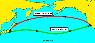
Jet stream
Jet streams are fast flowing, narrow air currents found in the atmospheres of some planets, including Earth. The main jet streams are located near the tropopause, the transition between the troposphere and the stratosphere . The major jet streams on Earth are westerly winds...
may be an hour shorter than those going against it. Ocean tracks often start and finish perhaps a hundred miles offshore at named waypoints to which a number of airways connect. Tracks across northern oceans are suitable for east-west or west-east flights, which constitute the bulk of the traffic in these areas.
Complete routes
There are a number of ways of constructing a route. All scenarios using airways use SIDs and STARs for departure and arrival. Any mention of airways might include a very small number of 'direct' segments to allow for situations when there are no convenient airway junctions. In some cases political considerations may influence the choice of route (e.g. aircraft from one country cannot overfly some other country).- Airway(s) from origin to destination. Most flights over land fall into this category.
- Airway(s) from origin to an ocean edge, then an ocean track, then airway(s) from ocean edge to destination. Most flights over northern oceans fall into this category.
- Airway(s) from origin to an ocean edge, then a free-flight area across an ocean, then airway(s) from ocean edge to destination. Most flights over southern oceans fall into this category
- Free-flight area from origin to destination. This is a relatively uncommon situation for commercial flights.
Even in a free-flight area, air traffic control still requires a position report about once an hour. Flight planning systems organise this by inserting geographic waypoints at suitable intervals. For a jet aircraft these intervals are 10 degrees of longitude for east-bound or west-bound flights and 5 degrees of latitude for north-bound or south-bound flights. In free-flight areas commercial aircraft normally follow a least-time-track so as to use as little time and fuel as possible. A great circle
Great circle
A great circle, also known as a Riemannian circle, of a sphere is the intersection of the sphere and a plane which passes through the center point of the sphere, as opposed to a general circle of a sphere where the plane is not required to pass through the center...
route would have the shortest ground distance, but is unlikely to have the shortest air-distance, due to the effect of head or tail winds. A flight planning system may have to do quite a lot of analysis in order to determine a good free-flight route.
Fuel calculation
Calculation of fuel requirements (especially trip fuel and reserve fuel) is the most safety-criticalLife-critical system
A life-critical system or safety-critical system is a system whose failure ormalfunction may result in:* death or serious injury to people, or* loss or severe damage to equipment or* environmental harm....
aspect of flight planning. This calculation is somewhat complicated:
- Rate of fuel burn depends on ambient temperature, aircraft speed, and aircraft altitude, none of which are entirely predictable.
- Rate of fuel burn also depends on airplane weight, which changes as fuel is burned.
- Some iterationIterationIteration means the act of repeating a process usually with the aim of approaching a desired goal or target or result. Each repetition of the process is also called an "iteration," and the results of one iteration are used as the starting point for the next iteration.-Mathematics:Iteration in...
is generally required due to the need to calculate interdependent values. For instance, reserve fuel is often calculated as a percentage of trip fuel, but trip fuel can't be calculated until the total weight of the aircraft is known and this includes the weight of the reserve fuel.
Considerations
Fuel calculation must take many factors into account.- Weather forecasts
- The air temperature affects the efficiency/fuel consumption of aircraft engines. The wind may provide a head or tail wind component which in turn will increase or decrease the fuel consumption by increasing or decreasing the air distance to be flown.
- By agreementWorld Area Forecast CenterA World Area Forecast Centre is a meteorological centre that provides real-time meteorological information broadcasts for aviation purposes. These broadcasts are supervised by ICAO in order to fulfill requirements of the ICAO Annex 3 covering meteorological information which is necessary for...
with the International Civil Aviation OrganizationInternational Civil Aviation OrganizationThe International Civil Aviation Organization , pronounced , , is a specialized agency of the United Nations. It codifies the principles and techniques of international air navigation and fosters the planning and development of international air transport to ensure safe and orderly growth...
, there are two national weather centres (in U.S.A.National Oceanic and Atmospheric AdministrationThe National Oceanic and Atmospheric Administration , pronounced , like "noah", is a scientific agency within the United States Department of Commerce focused on the conditions of the oceans and the atmosphere...
and U.K.Met OfficeThe Met Office , is the United Kingdom's national weather service, and a trading fund of the Department for Business, Innovation and Skills...
) which provide worldwide weather forecasts for civil aviation in a format known as GRIBGRIBGRIB is a mathematically concise data format commonly used in meteorology to store historical and forecast weather data...
weather. These forecasts are generally issued every 6 hours, and cover the next 36 hours at intervals of 6 hours. Each 6-hour forecast covers the whole world using gridpoints located at intervals of 75 nautical miles (138.9 km) or less. At each grid point the weather (wind speed, wind direction, air temperature) is supplied at 9 different heights ranging from about 4500 feet (1,371.6 m) up to about 55000 feet (16,764 m).
- Aircraft seldom fly exactly through weather gridpoints or at the exact heights at which weather predictions are available, so some form of horizontal and vertical interpolation is generally needed. For 75 nautical miles (138.9 km) intervals, linear interpolation is satisfactory. GRIB format superseded the earlier ADF format in 1998/9. The ADF format used 300 nautical miles (555.6 km) intervals; this interval was large enough to miss some storms completely, so calculations using ADF predicted weather were often not as accurate as those which can be produced using GRIB weather.
- Routes and flight levels
- The particular route to be flown determines the ground distance to cover, while winds on that route determine the air distance to be flown. Each inter-waypoint portion of an airway may have different rules as to which flight levels may be used. Total aircraft weight at any point determines the highest flight level which can be used. Cruising at a higher flight level generally requires less fuel than at a lower flight level, but extra climb fuel may be needed to get up to the higher flight level (it is this extra climb fuel and the different fuel consumption rate which cause discontinuities).
- Physical constraints
- Almost all the weights mentioned above in 'Overview and basic terminology' may be subject to minimum and/or maximum values. Due to stress on the wheels and undercarriage when landing, the maximum safe landing weight may be considerably less than the maximum safe brake-release weight. In such cases, an aircraft which encounters some emergency and has to land straight after taking off may have to circle for a while to use up fuel, or else jettison some fuel, or else land immediately and risk having the undercarriage collapse.
- Also, the fuel tanks have some maximum capacity. On some occasions, commercial flight planning systems find that an impossible flight plan has been requested. The aircraft can't possibly reach the intended destination, even with no cargo or passengers, since the fuel tanks are just not big enough to hold the amount of fuel needed; it would appear that some airlines are over-optimistic at times, perhaps hoping for a (very) strong tailwind.
- Fuel consumption rate
- The rate of fuel consumption for aircraft engines depends on: air temperature, height as measured by air pressure, aircraft weight, aircraft speed relative to the air, and any increased consumption as compared with brand-new engines due to engine age and/or poor maintenance (an airline can estimate this degradation by comparing actual and predicted fuel burn). Note that a large aircraft such as a jumbo jet may burn up to 80 tons of fuel on a 10 hour flight, so there is a substantial weight change during the flight.
Calculation
The weight of fuel forms a significant part of the total weight of an aircraft, so any fuel calculation must take into account the weight of any fuel not yet burnt. Instead of trying to predict fuel load not yet burnt, a flight planning system can handle this situation by working backwards along the route, starting at the alternate, going back to the destination, and then going back waypoint by waypoint to the origin.A more detailed outline of the calculation follows. Several (possibly many) iterations are usually required, either to calculate interdependent values such as reserve fuel and trip fuel, or to cope with situations where some physical constraint has been exceeded. In the latter case it is usually necessary to reduce the payload (less cargo or less passengers). Some flight planning systems use elaborate systems of approximate equations to simultaneously estimate all the changes required; this can greatly reduce the number of iterations needed.
- If an aircraft lands at the alternate, in the worst case it can be assumed to have no fuel left (in practice there will be enough reserve fuel left to at least taxi off the runway). Hence a flight planning system can calculate alternate holding fuel on the basis that the final aircraft weight is just the zero fuel weight. Since the aircraft is circling while holding there is no need to take wind into account for this or any other holding calculation.
- For the flight from destination to alternate, a flight planning system can calculate alternate trip fuel and alternate reserve fuel on the basis that the aircraft weight on reaching the alternate is zero fuel weight plus alternate holding.
- A flight planning system can then calculate any destination holding on the basis that the final aircraft weight is zero fuel weight plus alternate holding plus alternate fuel plus alternate reserve.
- For the flight from origin to destination, the weight on arrival at the destination can be taken as zero fuel weight plus alternate holding plus alternate fuel plus alternate reserve plus destination holding. A flight planning system can then work back along the route, calculating the trip fuel and reserve fuel one waypoint at a time, with the fuel required for each inter-waypoint segment forming part of the aircraft weight for the next segment to be calculated.
- At each stage and/or at the end of the calculation, a flight planning system must carry out checks to ensure that physical constraints (e.g. maximum tank capacity) have not been exceeded. Problems mean that either the aircraft weight must be reduced in some fashion, or else the calculation must be abandoned.
An alternative approach to fuel calculation is to calculate alternate and holding fuel as above, and obtain some estimate of the total trip fuel requirement, either based on previous experience with that route and aircraft type, or by using some approximate formula; neither method can take much account of weather. Calculation can then proceed forwards along the route waypoint by waypoint. On reaching the destination, the actual trip fuel can be compared with the estimated trip fuel, a better estimate made, and the calculation repeated as required.
Cost reduction
Commercial airlines generally wish to keep the cost of a flight as low as possible. There are three main factors which contribute to the cost:- amount of fuel needed (to complicate matters, fuel may cost different amounts at different airports),
- actual flying time affects depreciation charges and maintenance schedules etc.,
- overflight charges are levied by each country the aircraft flies over (notionally to cover air traffic control costs).
Different airlines have different views as to what constitutes a least cost flight:
- Least cost based only on time.
- Least cost based only on fuel.
- Least cost based on a balance between fuel and time.
- Least cost based on fuel costs and time costs and overflight charges.
Basic improvements
For any given route, a flight planning system can reduce cost by finding the most economical speed at any given altitude, and by finding the best altitude(s) to use based on the predicted weather. Such local optimisation can be done on a waypoint by waypoint basis.Commercial airlines do not want an aircraft to change altitude too often (among other things, it may make it more difficult for the cabin crew to serve meals), so they often specify some minimum time between optimisation-related flight level changes. To cope with such requirements a flight planning system must be capable of non-local altitude optimisation by simultaneously taking a number of waypoints into account, along with the fuel costs for any short climbs that may be required.
When there is more than one possible route between the origin and destination airports, the task facing a flight planning system becomes more complicated, since it must now consider many routes in order to find the best available route. Many situations have tens or even hundreds of possible routes, and there are some situations with over 25,000 possible routes (e.g. London to New York with free-flight below the track system). The amount of calculation required to produce an accurate flight plan is so substantial that it is not feasible to examine every possible route in detail. A flight planning system must have some fast way of cutting the number of possibilities down to a manageable number before undertaking a detailed analysis.
Reserve reduction
From an accountant's viewpoint, the provision of reserve fuel costs money (the fuel needed to carry the hopefully unused reserve fuel). Techniques known variously as reclear or redispatch or decision point procedure have been developed, which can greatly reduce the amount of reserve fuel needed while still maintaining all required safety standards. These techniques are based on having some specified intermediate airport to which the flight can divert if necessary; in practice such diversions are rare. The use of such techniques can save several tons of fuel on long flights, or it can increase the payload carried by a similar amount.A reclear flight plan has two destinations. The final destination airport is where the flight is really going to, while the initial destination airport is where the flight will divert to if more fuel is used than expected during the early part of the flight. The waypoint at which the decision is made as to which destination to go to is called the reclear fix or decision point. On reaching this waypoint, the flight crew make a comparison between actual and predicted fuel burn and check how much reserve fuel is available. If there is sufficient reserve fuel then the flight can continue to the final destination airport, otherwise the aircraft must divert to the initial destination airport.
The initial destination is positioned so that less reserve fuel is needed for a flight from the origin to the initial destination than for a flight from the origin to the final destination. Under normal circumstances little if any of the reserve fuel is actually used, so when the aircraft reaches the reclear fix it still has (almost) all the original reserve fuel on board, which is enough to cover the flight from the reclear fix to the final destination.
The idea of reclear flights was first published in 'Boeing Airliner' (1977) by Boeing engineers David Arthur and Gary Rose. The original paper contains a lot of magic numbers
Magic number (programming)
In computer programming, the term magic number has multiple meanings. It could refer to one or more of the following:* A constant numerical or text value used to identify a file format or protocol; for files, see List of file signatures...
relating to the optimum position of the reclear fix, etc. These numbers apply only to the specific type of aircraft considered, for a specific reserve percentage, and take no account of the effect of weather. The fuel savings due to reclear depend on three factors:
- The maximum achievable saving depends on the position of the reclear fix. This position can't be determined theoretically since there are no exact equations for trip fuel and reserve fuel. Even if it could be determined exactly, there may not be a waypoint at the right place anyway.
- One factor identified by Arthur and Rose which helps achieve the maximum possible saving is to have an initial destination which is positioned so that descent to the initial destination starts immediately after the reclear fix. This is beneficial because it minimises the reserve fuel needed between reclear fix and initial destination, and hence maximises the amount of reserve fuel available at the reclear fix.
- The other factor which is also helpful depends on the positioning of the initial alternate airport.
Filing suboptimal plans
Despite all the effort taken to optimise flight plans there are certain circumstances where it is advantageous to file suboptimal plans. In busy airspace with a number of competing aircraft, the optimum routes and preferred altitudes may well be oversubscribed. This problem can be made worse by busy periods, for example where everyone wants to arrive at an airport as soon as it opens for the day. If all the aircraft file an optimal flight plan then to avoid overloading, air traffic control may refuse permission for some of the flight plans or delay the allocated takeoff slots. To avoid this a suboptimal flight plan can be filed, asking for an inefficiently low altitude or a longer less congested route.Once airborne the part of the pilot's job is to fly as efficiently as possible so he/she might then try to convince air traffic control to allow him to fly closer to the optimum route. This might involve requesting a higher flight level than in the plan or asking for a more direct routing. If the controller does not immediately agree it may be possible to rerequest occasionally until they relent. Alternatively if there has been any bad weather reported in the area a pilot might request a climb or turn to avoid weather. As air traffic controllers do not know the precise location and height of pockets of turbulence, they would not know if the pilot was exaggerating the problem to get a more efficient route.
Even if the pilot does not manage to revert to the optimal route the benefits of being allowed to fly may well outweigh the cost of the suboptimal route.
Additional features
Over and above the various cost-reduction measures mentioned above, flight planning systems may offer extra features to help attract and retain customers:- Other routes
- While a flight plan is produced for a specific route, flight dispatchers may wish to consider alternative routes. A flight planning system may produce summaries for say the next 4 best routes, showing zero fuel weight and total fuel for each possibility.
- Reclear selection
- There may be several possible reclear fixes and initial destinations, and which one is best depends on the weather and the zero fuel weight. A flight planning system can analyse each possibility and select whichever is best for this particular flight.
- What-if summaries
- On congested routes air traffic control may require that an aircraft fly lower or higher than optimum. The total weight of passengers and cargo might not be known at the time the flight plan is prepared. To allow for these situations a flight planning system may produce summaries showing how much fuel would be needed if the aircraft is a little lighter or heavier, or if it is flying higher or lower than planned. These summaries allow flight dispatchers and pilots to check if there is enough reserve fuel to cope with a different scenario.
- Fuel tank distribution
- Most commercial aircraft have more than one fuel tank, and an aircraft manufacturer may provide rules as to how much fuel to load into each tank so as to avoid affecting the aircraft centre of gravity. The rules depend on how much fuel is to be loaded, and there may be different sets of rules for different total amounts of fuel. A flight planning system may follow these rules and produce a report showing how much fuel is to be loaded into each tank.
- Tankering fuel
- When fuel prices differ between airports, it might be worth putting in more fuel where it is cheap, even taking into account the cost of extra trip fuel needed to carry the extra weight. A flight planning system can work out how much extra fuel can profitably be carried. Note that discontinuities due to changes in flight levels can mean that a difference of as little as 100 kg (one passenger with luggage) in zero fuel weight or tankering fuel can make the difference between profit and loss.
- Inflight diversion
- While en route, an aircraft may be diverted to some airport other than the planned alternate. A flight planning system can produce a new flight plan for the new route from the diversion point and transmit it to the aircraft, including a check that there will be enough fuel for the revised flight.
- Inflight refuelling
- Military aircraft may refuel in mid-air. Such refuelling is a gradual process rather than instantaneous. Some flight planning systems can allow for the change in fuel and show the effect on each aircraft involved.
See also
- Air navigationAir navigationThe basic principles of air navigation are identical to general navigation, which includes the process of planning, recording, and controlling the movement of a craft from one place to another....
- Air safetyAir safetyAir safety is a term encompassing the theory, investigation and categorization of flight failures, and the prevention of such failures through regulation, education and training. It can also be applied in the context of campaigns that inform the public as to the safety of air travel.-United...
- Air speedAirspeedAirspeed is the speed of an aircraft relative to the air. Among the common conventions for qualifying airspeed are: indicated airspeed , calibrated airspeed , true airspeed , equivalent airspeed and density airspeed....
- Air traffic controlAir traffic controlAir traffic control is a service provided by ground-based controllers who direct aircraft on the ground and in the air. The primary purpose of ATC systems worldwide is to separate aircraft to prevent collisions, to organize and expedite the flow of traffic, and to provide information and other...
- Air traffic controllerAir traffic controllerAir traffic controllers are the people who expedite and maintain a safe and orderly flow of air traffic in the global air traffic control system. The position of the air traffic controller is one that requires highly specialized skills...
- Balanced field takeoffBalanced field takeoffA balanced field takeoff is a condition where the accelerate-stop distance required is equal to the takeoff distance required for the aircraft weight, engine thrust, aircraft configuration and runway condition...
- CANSOCansoCanso can refer to several different things:* Canso, Nova Scotia, a small fishing town in eastern Nova Scotia, Canada.* Canso Causeway, a rock-fill causeway connecting Cape Breton Island to mainland Nova Scotia, Canada...
(the Civil Air Navigation Services Organisation) - ClimbClimbthumb|right|An [[Embraer ERJ 145]] climbingIn aviation, the term climb refers both to the actual operation of increasing the altitude of an aircraft and to the logical phase of a typical flight following take-off and preceding the cruise, during which an increase in altitude to a predetermined...
- Step climbStep climbA step climb in aviation is a series of altitude gains that improve fuel economy by moving into thinner air as an aircraft becomes lighter and becomes capable of faster, more economical flight.-Description:...
- CruiseCruise (flight)Cruise is the level portion of aircraft travel where flight is most fuel efficient. It occurs between ascent and descent phases and is usually the majority of a journey. Technically, cruising consists of heading changes only at a constant airspeed and altitude...
- DescentDescent (aircraft)A descent during air travel is any portion where an aircraft decreases altitude, and is the opposite of an ascent or climb. Descents are an essential component of an approach to landing...
- Flight dispatcher
- Flight planFlight planFlight plans are documents filed by pilots or a Flight Dispatcher with the local Civil Aviation Authority prior to departure...
- Holding
- Instrument flight rulesInstrument flight rulesInstrument flight rules are one of two sets of regulations governing all aspects of civil aviation aircraft operations; the other are visual flight rules ....
- LandingLandingthumb|A [[Mute Swan]] alighting. Note the ruffled feathers on top of the wings indicate that the swan is flying at the [[Stall |stall]]ing speed...
- RunwayRunwayAccording to ICAO a runway is a "defined rectangular area on a land aerodrome prepared for the landing and take-off of aircraft." Runways may be a man-made surface or a natural surface .- Orientation and dimensions :Runways are named by a number between 01 and 36, which is generally one tenth...
- SIGISigiIn the Völsung cycle, Sigi is the ancestor of the Völsung lineage. In the Völsunga saga , he is said to be one of the sons of Odin. He is also listed among Odin's sons in the Nafnaþulur. He had a son called Rerir....
- Take-offTakeoffTakeoff is the phase of flight in which an aerospace vehicle goes from the ground to flying in the air.For horizontal takeoff aircraft this usually involves starting with a transition from moving along the ground on a runway. For balloons, helicopters and some specialized fixed-wing aircraft , no...
- TaxiingTaxiingTaxiing refers to the movement of an aircraft on the ground, under its own power, in contrast to towing or push-back where the aircraft is moved by a tug...
- Visual flight rulesVisual flight rulesVisual flight rules are a set of regulations which allow a pilot to operate an aircraft in weather conditions generally clear enough to allow the pilot to see where the aircraft is going. Specifically, the weather must be better than basic VFR weather minimums, as specified in the rules of the...
- Maximum Takeoff Weight
- Maximum Landing WeightMaximum Landing WeightThe Maximum Landing Weight is the maximum aircraft gross weight due to design or operational limitations at which an aircraft is permitted to land...
- Maximum Zero Fuel WeightMaximum Zero-Fuel WeightThe Zero Fuel Weight of an airplane is the total weight of the airplane and all its contents, minus the total weight of the fuel on board....
Flight planning providers
- AirData - (part of World Fuel ServicesWorld Fuel ServicesWorld Fuel Services is a Fortune 500 company that is based in Miami, Florida. It provides marketing and financing of aviation, marine and ground transportation fuel products and related services to commercial and corporate aircraft, petroleum distributors and ships at more than 2,500 locations...
) - Air Routing InternationalAir Routing InternationalAir Routing International , a Rockwell Collins company, is a leading worldwide provider of international trip support and corporate flight handling since 1978. It is also the new home for Ascend™ International Trip Quotes.Air Routing International was founded by Rudy Fabre, Tom Balousek, and...
- Air Partner PLCAir Partner PLCAir Partner plc is a provider of private aviation services, which celebrated its 50th anniversary in 2011. In 1961 it started out as an air training school. Today, Air Partner organizes over 15,000 flights per year airliner, private jet and freight charters for industry, commerce, governments and...
- ARINCARINCAeronautical Radio, Incorporated , established in 1929, is a major provider of transport communications and systems engineering solutions for eight industries: aviation, airports, defense, government, healthcare, networks, security, and transportation...
- Electronic Data SystemsElectronic Data SystemsHP Enterprise Services is the global business and technology services division of Hewlett Packard's HP Enterprise Business strategic business unit. It was formed by the combination of HP's legacy services consulting and outsourcing business and the integration of acquired Electronic Data Systems,...
- EDS - FlightAwareFlightAwareFlightAware is an aviation software and data services company. Based in Houston, Texas, it is best known for the flightaware.com web site, the first to offer free flight tracking of both private and commercial aircraft in the United States...
- Fltplan.comFltplan.comFltPlan.com is an online company which serves the general and corporate aviation community. Founded in 1999, it originally concentrated on flight planning...
- flugwerkzeuge aviation software - f:wz (part of Sabre HoldingsSabre HoldingsSabre Holdings or Sabre, Inc. is an American privately held travel technology company, encompassing several brands in three global distribution system channels: travel agency, airline, and direct to consumer. These areas are serviced by TSG's three main business groups...
) - JeppesenJeppesenJeppesen is an American company that specializes in navigational information, operations management solutions and flight training products and services...
- Lufthansa SystemsLufthansa SystemsLufthansa Systems AG is an IT service provider for the aviation industry. It has around 3,000 employees in several locations in Germany and offices in 14 other countries and is headquartered in Kelsterbach near Frankfurt....
- Navtech
- Portable Flight Planning SoftwarePortable Flight Planning SoftwareThe Portable Flight Planning Software, or PFPS is a suite of software for planning air missions built by TYBRIN Corporation. The suite includes the FalconView mapping system, Combat Flight Planning Software , Combat Weapon Delivery Software , Combat Air Drop Planning Software and several other...
(Military) - Sabre Airline SolutionsSabre Airline SolutionsSabre Airline Solutions is a subsidiary of Sabre Holdings. The main product of Sabre Airline Solutions is the SabreSonic system. This provides departure control, reservations, and, inventory management. Other products include resource management, fares and revenue management, data services,...
- SITASITASITA is a multinational information technology company specialising in providing IT and telecommunication services to the air transport industry...
- Universal Weather and Aviation (Business Aviation) 3d Flight Planning Software
- TopoFlightTopoFlightTopoFlight is a three-dimensional flight planning software that was originally conceived by a team of experts in the mapping industry, in use since 2003...
- World Air Operations