

Flamborough, Ontario
Encyclopedia
Flamborough is a former town near, and a current community in, Hamilton
, Ontario
, Canada
.
For most of its existence before amalgamation
with Hamilton in 2001, Flamborough comprised the former townships of East Flamborough, West Flamborough, and Beverly, as well as the Village of Waterdown. The largest suburban community is the former Village of Waterdown
containing perhaps one third of its thirty thousand or so inhabitants. Other Flamborough communities include: Carlisle
, Christie's Corners, Clappison's Corners, Copetown
, Freelton, Greensville
, Lynden
, Kirkwall, Millgrove
, Mountsberg, Orkney, Rockton, Troy, Sheffield, Valens, and Westover.
nations from what is now New York State. The first recorded visit to the area by Europeans was on September 24, 1669, when the French explorers La Salle and Joliet met near Tinawatawa, now Westover. When New France
was conquered by the British in 1763, the territory became part of the British Empire
.
After the American Revolution
in 1783 and the creation of Upper Canada
, land at the western end of Lake Ontario was surveyed and organized into townships, which included East Flamborough, West Flamborough and Beverly. Governor's Road (also known as Queen's Highway 99 and later Regional Roads 399 and 299) was built on the border with neighbouring Ancaster
Township in 1794-95, linking York (later Toronto) and London
.
The three townships and Village of Waterdown were founding constituents of Wentworth County
in 1816. The Village of Waterdown
was created in 1879 from that part of East Flamborough above the Niagara Escarpment
and within approximately a kilometre of King's Highway No. 5 (Dundas Street). The Town of Dundas
was created from parts of West Flamborough and Ancaster Townships.
Lionel Beaumaurice "Leo" Clarke
was born near Waterdown in 1892, and his family left for Winnipeg
, Manitoba
, in 1903. During the First World War, he enlisted in the Canadian Expeditionary Force
and fought in France
. On September 9, 1916, during the Battle of Somme, Corporal L.B. Clarke single-handedly repulse a German attack. Unfortunately, he was killed in combat on October 19, 1916 before he could receive his Victoria Cross
.
The newsletter of The Waterdown East Flamborough Heritage Society explained in its April 2011 edition:
Arms and flags have a long history in this country, and are important tools used to project identity. Often a community’s flag and coat of arms are residents’ only reminders of their area’s rich history. It was with this idea in mind that a grant of arms committee was struck by the WEFHS in 2009.
members from every corner of the historic Flamborough-Beverly region, the committee worked closely with the Canadian Heraldic Authority (and in particular Dr. Forrest Pass, the Herald assigned to the file) to create a symbol that reflected our unique corner of the world, including both its human and natural aspects. After their first gathering in the Dart Room of the Royal Coachman, meetings were held in Rockton, Greensville, Waterdown, Carlisle, Clappisons Corners, Strabane, and Clyde as various symbols were hotly debated. Historic township seals were consulted, as well as previous symbols of the Town of Flamborough. In creating a motto for the community, every school in the area (over 20) were consulted and students were asked to send in their suggestions.'
On May 10, 2011, the Flamborough flag was raised over Waterdown District High School in the presence of its student body, as well as a delegation from Allan A. Greenleaf Public School.
The top portion of the shield is green with a triangular notch in the middle, pointing upwards, charged with two gold crowns of maple leaves. This section recalls the dormer of an Ontario Cottage, a nineteenth-century vernacular architectural style common throughout Flamborough. A dormer also appears in the logo of the Waterdown-East Flamborough Heritage Society. The shape also recalls a plough moving through green turf, a reference agriculture and the early pioneers of this area.
The coronets depict the human history of the area, as well as its connections with the British and Canadian Crowns.
The pine tree appeared on a number of previous seals and arms of Flamborough's communities and represents the white pines that use to dominate the landscape.
The four wavy lines represent the four major wateways (Grindstone, Bronte, Spencer and Fairchild Creeks) and waterfalls (Webster’s, Tews, Borers and the Great Falls) of the region. By their convergence, they also represent the amalgamation of the three townships with the village of Waterdown to create the Township (later Town) of Flamborough in 1974.
The horse symbolizes the early pioneers of the Flamborough area and the continuing importance and contribution of agriculture. It also illustrates the importance of the horse in development of the area and is also a reference to the iconic Rockton World’s Fair.
The Great Blue Heron is a common sight in the area marshes and along the waterways of the community. In particular, the heron represents the Beverly Swamp.•The arrowheads recall the Aboriginal People of the 'Neutral' and 'Attawandaron' nation, who were the first known human inhabitants of the Flamborough-Beverly area.
The eastern green violet represents the Beverly Swamp, which is home to a provincially significant concentration of the rare flower.
The trillium is the provincial flower of Ontario and the red variety is found in abundance in the Flamborough area. The number of trilliums represent the three areas (Dundas, Aldershot & Clyde) that have been annexed from Flamborough by surrounding municipalities (except Dundas which became independent).
in Halton Region. Flamborough became a town in 1985.
Although the existence of the Hamilton-Wentworth regional government was supposed to preserve the rural and semi-urban character of Flamborough from encroachment by its larger urban neighbour, the reprieve did not last long as several country libraries were forced to close. In 2001, the provincial government disbanded Hamilton-Wentworth
and its constituent municipalities and replaced them with a new single tier municipality called the City of Hamilton
after its largest member.
The amalgamation was bitterly and unsuccessfully protested by some Flamborough residents and those of adjacent communities, particularly since the incumbent Progressive Conservative MPP, Toni Skarica's government had promised in the previous election that the amalgamation would not occur. Skarica resigned in protest, but the amalgamation was not rescinded.
The population of Flamborough at the 2001 census was 37,796. By the 2006 census, its population had increased to 39,220.
; thus the Bruce Trail
passes through the area. Although relatively flat in the south, a slow but steady incline is observable until reaching the Wellington County
line which is the approximate height of land dividing two watersheds. The Beverly Swamp, located in the western part of the former Beverly Township, is another important physiographic area.
Notable natural attractions operated by the Hamilton Conservation Authority
include:
. Much of the arable land is devoted to raising corn, strawberries and cash crops.
In recent decades, Flamborough has become home to commuters and hobby farmers in the Golden Horseshoe
. It has easy access to secondary highways, especially with the opening of an interchange with Highway 403 at Waterdown Road, granting easier access for traffic to/from Toronto.
Notable attractions operated as commercial enterprises include:
Hamilton, Ontario
Hamilton is a port city in the Canadian province of Ontario. Conceived by George Hamilton when he purchased the Durand farm shortly after the War of 1812, Hamilton has become the centre of a densely populated and industrialized region at the west end of Lake Ontario known as the Golden Horseshoe...
, Ontario
Ontario
Ontario is a province of Canada, located in east-central Canada. It is Canada's most populous province and second largest in total area. It is home to the nation's most populous city, Toronto, and the nation's capital, Ottawa....
, Canada
Canada
Canada is a North American country consisting of ten provinces and three territories. Located in the northern part of the continent, it extends from the Atlantic Ocean in the east to the Pacific Ocean in the west, and northward into the Arctic Ocean...
.
For most of its existence before amalgamation
Amalgamation (politics)
A merger or amalgamation in a political or administrative sense is the combination of two or more political or administrative entities such as municipalities , counties, districts, etc. into a single entity. This term is used when the process occurs within a sovereign entity...
with Hamilton in 2001, Flamborough comprised the former townships of East Flamborough, West Flamborough, and Beverly, as well as the Village of Waterdown. The largest suburban community is the former Village of Waterdown
Waterdown, Ontario
Waterdown is a town in Canada which since 2001 has been a community of Hamilton, Ontario.On January 1, 2001 the new city of Hamilton was formed from the amalgamation of the Regional Municipality of Hamilton-Wentworth and its six municipalities: Hamilton, Ancaster, Dundas, Flamborough, Glanbrook,...
containing perhaps one third of its thirty thousand or so inhabitants. Other Flamborough communities include: Carlisle
Carlisle, Hamilton, Ontario
Carlisle is a community in Flamborough, Hamilton, Ontario, Canada. Carlisle lies at the intersection of Carlisle Road and Centre Road, about 15 kilometres north of Waterdown.Carlisle is home to the Progresston waterfalls.-References:1....
, Christie's Corners, Clappison's Corners, Copetown
Copetown, Ontario
Copetown is a community that is east of Brantford in the southern region of Ontario, Canada. Dundas Hill is located nearby, signifying its closeness to Dundas. There are a various number of golf courses within the local area.-General summary:...
, Freelton, Greensville
Greensville, Ontario
Greensville is a community in Flamborough, Hamilton in the Canadian province of Ontario.Hamilton Conservation Authority attractions Webster's Falls and Tew's Falls are in Greensville....
, Lynden
Lynden, Ontario
Lynden, Ontario is part of Flamborough, currently part of the city of Hamilton. Lynden now has fewer than 500 residents. There used to be a train station in Lynden that went to Hamilton and Lynden provided goods to that city...
, Kirkwall, Millgrove
Millgrove, Ontario
Millgrove is a community in the Canadian province of Ontario. It is located within the former township of West Flamborough of the Flamborough region and is a part of the amalgamated city of Hamilton...
, Mountsberg, Orkney, Rockton, Troy, Sheffield, Valens, and Westover.
History
The area has a long history of human occupation. There is evidence in the immediate area of Paleo-Indian occupation. Later, the area was inhabited by the aboriginal people known variously as the Neutral or Attawandaron until they were annihilated by the IroquoisIroquois
The Iroquois , also known as the Haudenosaunee or the "People of the Longhouse", are an association of several tribes of indigenous people of North America...
nations from what is now New York State. The first recorded visit to the area by Europeans was on September 24, 1669, when the French explorers La Salle and Joliet met near Tinawatawa, now Westover. When New France
New France
New France was the area colonized by France in North America during a period beginning with the exploration of the Saint Lawrence River by Jacques Cartier in 1534 and ending with the cession of New France to Spain and Great Britain in 1763...
was conquered by the British in 1763, the territory became part of the British Empire
British Empire
The British Empire comprised the dominions, colonies, protectorates, mandates and other territories ruled or administered by the United Kingdom. It originated with the overseas colonies and trading posts established by England in the late 16th and early 17th centuries. At its height, it was the...
.
After the American Revolution
American Revolution
The American Revolution was the political upheaval during the last half of the 18th century in which thirteen colonies in North America joined together to break free from the British Empire, combining to become the United States of America...
in 1783 and the creation of Upper Canada
Upper Canada
The Province of Upper Canada was a political division in British Canada established in 1791 by the British Empire to govern the central third of the lands in British North America and to accommodate Loyalist refugees from the United States of America after the American Revolution...
, land at the western end of Lake Ontario was surveyed and organized into townships, which included East Flamborough, West Flamborough and Beverly. Governor's Road (also known as Queen's Highway 99 and later Regional Roads 399 and 299) was built on the border with neighbouring Ancaster
Ancaster, Ontario
Ancaster is a picturesque and historic community located on the Niagara escarpment, within the greater area of the city of Hamilton, Ontario, Canada. This former town was founded officially in 1793 and was one of the oldest European communities established in present day Ontario along with Windsor...
Township in 1794-95, linking York (later Toronto) and London
London, Ontario
London is a city in Southwestern Ontario, Canada, situated along the Quebec City – Windsor Corridor. The city has a population of 352,395, and the metropolitan area has a population of 457,720, according to the 2006 Canadian census; the metro population in 2009 was estimated at 489,274. The city...
.
The three townships and Village of Waterdown were founding constituents of Wentworth County
Wentworth County, Ontario
Wentworth County, area , is a historic county in the Canadian province of Ontario.It was created in 1816 as part of the Gore District in what was then Upper Canada and later Canada West...
in 1816. The Village of Waterdown
Waterdown, Ontario
Waterdown is a town in Canada which since 2001 has been a community of Hamilton, Ontario.On January 1, 2001 the new city of Hamilton was formed from the amalgamation of the Regional Municipality of Hamilton-Wentworth and its six municipalities: Hamilton, Ancaster, Dundas, Flamborough, Glanbrook,...
was created in 1879 from that part of East Flamborough above the Niagara Escarpment
Niagara Escarpment
The Niagara Escarpment is a long escarpment, or cuesta, in the United States and Canada that runs westward from New York State, through Ontario, Michigan, Wisconsin and Illinois...
and within approximately a kilometre of King's Highway No. 5 (Dundas Street). The Town of Dundas
Dundas, Ontario
Dundas is a formerly independent town and now constituent community in the city of Hamilton in Ontario, Canada. It's nickname is the Valley Town. The population has been stable for decades at about twenty thousand, largely because it has not annexed rural land from the protected Dundas Valley...
was created from parts of West Flamborough and Ancaster Townships.
Lionel Beaumaurice "Leo" Clarke
Leo Clarke
Leo Clarke, VC was a Canadian recipient of the Victoria Cross, the highest and most prestigious award for gallantry in the face of the enemy that can be awarded to British and Commonwealth forces.-Early life:...
was born near Waterdown in 1892, and his family left for Winnipeg
Winnipeg
Winnipeg is the capital and largest city of Manitoba, Canada, and is the primary municipality of the Winnipeg Capital Region, with more than half of Manitoba's population. It is located near the longitudinal centre of North America, at the confluence of the Red and Assiniboine Rivers .The name...
, Manitoba
Manitoba
Manitoba is a Canadian prairie province with an area of . The province has over 110,000 lakes and has a largely continental climate because of its flat topography. Agriculture, mostly concentrated in the fertile southern and western parts of the province, is vital to the province's economy; other...
, in 1903. During the First World War, he enlisted in the Canadian Expeditionary Force
Canadian Expeditionary Force
The Canadian Expeditionary Force was the designation of the field force created by Canada for service overseas in the First World War. Units of the C.E.F. were divided into field formation in France, where they were organized first into separate divisions and later joined together into a single...
and fought in France
France
The French Republic , The French Republic , The French Republic , (commonly known as France , is a unitary semi-presidential republic in Western Europe with several overseas territories and islands located on other continents and in the Indian, Pacific, and Atlantic oceans. Metropolitan France...
. On September 9, 1916, during the Battle of Somme, Corporal L.B. Clarke single-handedly repulse a German attack. Unfortunately, he was killed in combat on October 19, 1916 before he could receive his Victoria Cross
Victoria Cross
The Victoria Cross is the highest military decoration awarded for valour "in the face of the enemy" to members of the armed forces of various Commonwealth countries, and previous British Empire territories....
.
Flamborough Flag and Coat of Arms
On April 15, 2011, the Chief Herald of Canada (exercising the Royal Prerogative) granted arms, as well as a flag, to The Waterdown-East Flamborough Heritage Society that would reflect the historical Town of Flamborough. It is intended that these arms are to be used by the residents of Flamborough (including Beverly) to honour their history and identity. The arms and flag were presented to the community on April 29, 2011, by the Right Reverend Bishop Ralph Spence, Albion Herald Extraoridinary, at the Carlisle Golf & Country Club.The newsletter of The Waterdown East Flamborough Heritage Society explained in its April 2011 edition:
Arms and flags have a long history in this country, and are important tools used to project identity. Often a community’s flag and coat of arms are residents’ only reminders of their area’s rich history. It was with this idea in mind that a grant of arms committee was struck by the WEFHS in 2009.
members from every corner of the historic Flamborough-Beverly region, the committee worked closely with the Canadian Heraldic Authority (and in particular Dr. Forrest Pass, the Herald assigned to the file) to create a symbol that reflected our unique corner of the world, including both its human and natural aspects. After their first gathering in the Dart Room of the Royal Coachman, meetings were held in Rockton, Greensville, Waterdown, Carlisle, Clappisons Corners, Strabane, and Clyde as various symbols were hotly debated. Historic township seals were consulted, as well as previous symbols of the Town of Flamborough. In creating a motto for the community, every school in the area (over 20) were consulted and students were asked to send in their suggestions.'
On May 10, 2011, the Flamborough flag was raised over Waterdown District High School in the presence of its student body, as well as a delegation from Allan A. Greenleaf Public School.
Symbolism found in the Coat of Arms and Flag
The most important part of any coat of arms is the shield. The other elements around the shield are optional, however, they need to follow very strict guidelines of heraldic design.The Shield
A white shield with a green pine tree between two blue wavy triangles, rising from the base with their points converging toward the top of the shield.The top portion of the shield is green with a triangular notch in the middle, pointing upwards, charged with two gold crowns of maple leaves. This section recalls the dormer of an Ontario Cottage, a nineteenth-century vernacular architectural style common throughout Flamborough. A dormer also appears in the logo of the Waterdown-East Flamborough Heritage Society. The shape also recalls a plough moving through green turf, a reference agriculture and the early pioneers of this area.
The coronets depict the human history of the area, as well as its connections with the British and Canadian Crowns.
The pine tree appeared on a number of previous seals and arms of Flamborough's communities and represents the white pines that use to dominate the landscape.
The four wavy lines represent the four major wateways (Grindstone, Bronte, Spencer and Fairchild Creeks) and waterfalls (Webster’s, Tews, Borers and the Great Falls) of the region. By their convergence, they also represent the amalgamation of the three townships with the village of Waterdown to create the Township (later Town) of Flamborough in 1974.
Crest (top of the coat of arms)
A representation of the "Cobblestone Bridge" at Webster's Falls - a major landmark in the Flamborough region.Motto
"UNITED WE THRIVE" - developed by students from Greenville Public School and Rehoboth Christian School, as well as Kyle Menegaldo.Supporters (animals on either side)
On the left side of the shield is a horse and on the right a great blue heron. Both are wearing a medallion around their necks, depicting a blue arrowhead. They stand on a platform representing the Niagara Escarpment, charged with three red trilliums rising from a bed of green violets.The horse symbolizes the early pioneers of the Flamborough area and the continuing importance and contribution of agriculture. It also illustrates the importance of the horse in development of the area and is also a reference to the iconic Rockton World’s Fair.
The Great Blue Heron is a common sight in the area marshes and along the waterways of the community. In particular, the heron represents the Beverly Swamp.•The arrowheads recall the Aboriginal People of the 'Neutral' and 'Attawandaron' nation, who were the first known human inhabitants of the Flamborough-Beverly area.
The eastern green violet represents the Beverly Swamp, which is home to a provincially significant concentration of the rare flower.
The trillium is the provincial flower of Ontario and the red variety is found in abundance in the Flamborough area. The number of trilliums represent the three areas (Dundas, Aldershot & Clyde) that have been annexed from Flamborough by surrounding municipalities (except Dundas which became independent).
The Flag
A reinterpretation of the arms, focussed at the centre to recall the motto. Purposely divided into four parts, the flag represents the waterways, waterfalls and original townships of this region. The colours of the flag, as with the arms, are the ones used by Flamborough when it was its own municipality (1974-2001).Government
In 1974, the Hamilton-Wentworth Region was created with six constituent municipalities. Flamborough Township was created as one of these by amalgamating the townships of East Flamborough, West Flamborough, Beverly with the Village of Waterdown. At the same time, a small portion of Beverly Township near the community of Clyde was ceded to North Dumfries Township in Waterloo Region and a more populous but smaller portion of East Flamborough near the community of Aldershot was ceded to BurlingtonBurlington, Ontario
Burlington , is a city located in Halton Region at the western end of Lake Ontario. Burlington is part of the Greater Toronto Area, and is also included in the Hamilton Census Metropolitan Area. Physically, Burlington lies between the north shore of Lake Ontario and the Niagara Escarpment...
in Halton Region. Flamborough became a town in 1985.
Although the existence of the Hamilton-Wentworth regional government was supposed to preserve the rural and semi-urban character of Flamborough from encroachment by its larger urban neighbour, the reprieve did not last long as several country libraries were forced to close. In 2001, the provincial government disbanded Hamilton-Wentworth
Hamilton-Wentworth Regional Municipality, Ontario
The Regional Municipality of Hamilton-Wentworth was proclaimed by the Progressive Conservative government of Ontario on January 1, 1974 ....
and its constituent municipalities and replaced them with a new single tier municipality called the City of Hamilton
Hamilton, Ontario
Hamilton is a port city in the Canadian province of Ontario. Conceived by George Hamilton when he purchased the Durand farm shortly after the War of 1812, Hamilton has become the centre of a densely populated and industrialized region at the west end of Lake Ontario known as the Golden Horseshoe...
after its largest member.
The amalgamation was bitterly and unsuccessfully protested by some Flamborough residents and those of adjacent communities, particularly since the incumbent Progressive Conservative MPP, Toni Skarica's government had promised in the previous election that the amalgamation would not occur. Skarica resigned in protest, but the amalgamation was not rescinded.
The population of Flamborough at the 2001 census was 37,796. By the 2006 census, its population had increased to 39,220.
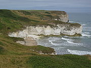
Geography and natural attractions
Much of Flamborough is located on top of the Niagara EscarpmentNiagara Escarpment
The Niagara Escarpment is a long escarpment, or cuesta, in the United States and Canada that runs westward from New York State, through Ontario, Michigan, Wisconsin and Illinois...
; thus the Bruce Trail
Bruce Trail
The Bruce Trail is a hiking trail in southern and central Ontario, Canada.-General:The trail follows the edge of the Niagara Escarpment, one of the thirteen UNESCO World Biosphere Reserves in Canada, for almost...
passes through the area. Although relatively flat in the south, a slow but steady incline is observable until reaching the Wellington County
Wellington County, Ontario
Wellington County is a county located in Southwestern Ontario, Canada. The county seat is Guelph, a city which is politically independent, but Guelph's status as the seat means it houses the county's administrative offices...
line which is the approximate height of land dividing two watersheds. The Beverly Swamp, located in the western part of the former Beverly Township, is another important physiographic area.
Notable natural attractions operated by the Hamilton Conservation Authority
Hamilton Conservation Authority
The Hamilton Conservation Authority maintains the greenspace, trails, parks and some attractions in the Hamilton, Ontario, Canada.The Hamilton Conservation Authority has managed the natural environment in partnership with the City of Hamilton and the Province of Ontario to help ensure a safe and...
include:
- Westfield Heritage CentreWestfield Heritage CentreThe Westfield Heritage Centre is home to the Westfield Heritage Village. The village contains over 30 historic buildings on a 3.4 square kilometres site. The village is located just west of Rockton, Ontario, Canada.-Brief history:...
, a living history museum containing pioneer era buildings moved from other locations across Ontario - Valens Conservation Area, offering camping and boating at its reservoir
- Christie Lake, swimming and stocked fishing at its reservoir
- Spencer Gorge and Webster's Falls Conservation Area, spectacular view of the falls and city below while hiking on the Bruce TrailBruce TrailThe Bruce Trail is a hiking trail in southern and central Ontario, Canada.-General:The trail follows the edge of the Niagara Escarpment, one of the thirteen UNESCO World Biosphere Reserves in Canada, for almost...
.
Economy and commercial attractions
After early European settlers had cleared the land of pine and oak forests, they began subsistence and then export farming. Disregarding the swamp and the excessively rocky areas of the Mountsberg area, the land is devoted chiefly to agricultureAgriculture
Agriculture is the cultivation of animals, plants, fungi and other life forms for food, fiber, and other products used to sustain life. Agriculture was the key implement in the rise of sedentary human civilization, whereby farming of domesticated species created food surpluses that nurtured the...
. Much of the arable land is devoted to raising corn, strawberries and cash crops.
In recent decades, Flamborough has become home to commuters and hobby farmers in the Golden Horseshoe
Golden Horseshoe
The Golden Horseshoe is a densely populated and industrialized region centred around the Greater Toronto Area at the western end of Lake Ontario in Southern Ontario, Canada, with outer boundaries stretching south to Lake Erie and north to Georgian Bay. Most of it is also part of the Quebec City...
. It has easy access to secondary highways, especially with the opening of an interchange with Highway 403 at Waterdown Road, granting easier access for traffic to/from Toronto.
Notable attractions operated as commercial enterprises include:
- Flamboro DownsFlamboro DownsFlamboro Downs is Canada's fastest half-mile harness horse racing track, based in Hamilton , Ontario since April, 1975. It is also home to Flamboro Slots, which has a total of 750 slot machines....
, featuring harness racingHarness racingHarness racing is a form of horse racing in which the horses race at a specific gait . They usually pull a two-wheeled cart called a sulky, although racing under saddle is also conducted in Europe.-Breeds:...
, and slot machines - Flamboro SpeedwayFlamboro SpeedwayFlamboro Speedway is a 1/3-mile semi-banked asphalt oval auto racing track in Hamilton , Ontario. The track was established in 1961....
, featuring car racing - African Lion SafariAfrican Lion SafariAfrican Lion Safari is a family-owned safari park situated in Flamborough, Hamilton, Ontario, Canada, about west of Toronto. The mailing address is in Cambridge, Ontario. It includes more than 1,000 animals, representing over 100 species of mammals and birds from across the globe...
, with land mammals and birds of prey in an open air zooZooA zoological garden, zoological park, menagerie, or zoo is a facility in which animals are confined within enclosures, displayed to the public, and in which they may also be bred.... - Rockton World's FairRockton World's FairThe Rockton World's Fair is an annual Thanksgiving weekend tradition in Flamborough, Ontario. The event takes place near Hamilton, Ontario, Canada....
, an agricultural exhibition held every Thanksgiving Weekend (Canadian)
External links
- Rockton World's Fair
- Flamborough Information and Community Services
- Scouts Canada - 1st Carlisle Group
- 3rd Waterdown Scouting
- Dufferin Masonic Lodge No. 291 A.F. & A.M.