

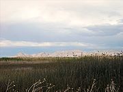
Fish Springs National Wildlife Refuge
Encyclopedia

Great Salt Lake Desert
The Great Salt Lake Desert is a large dry lake in northern Utah between the Great Salt Lake and the Nevada border which is noted for white sand from evaporite Lake Bonneville salt deposits...
, part of the
Great Basin
Great Basin
The Great Basin is the largest area of contiguous endorheic watersheds in North America and is noted for its arid conditions and Basin and Range topography that varies from the North American low point at Badwater Basin to the highest point of the contiguous United States, less than away at the...
in Juab County, Utah
Juab County, Utah
Juab County is a county located in the U.S. state of Utah. As of 2000 the population was 8,238, and by 2005 had been estimated at 9,113. It was named from an Indian word meaning thirsty valley, or possibly only valley. Its county seat and largest city is Nephi.Juab County is part of the...
. The Refuge is managed by the United States Fish and Wildlife Service
United States Fish and Wildlife Service
The United States Fish and Wildlife Service is a federal government agency within the United States Department of the Interior dedicated to the management of fish, wildlife, and natural habitats...
. As an oasis
Oasis
In geography, an oasis or cienega is an isolated area of vegetation in a desert, typically surrounding a spring or similar water source...
in the Great Basin
Great Basin
The Great Basin is the largest area of contiguous endorheic watersheds in North America and is noted for its arid conditions and Basin and Range topography that varies from the North American low point at Badwater Basin to the highest point of the contiguous United States, less than away at the...
Desert
Desert
A desert is a landscape or region that receives an extremely low amount of precipitation, less than enough to support growth of most plants. Most deserts have an average annual precipitation of less than...
in western Utah
Utah
Utah is a state in the Western United States. It was the 45th state to join the Union, on January 4, 1896. Approximately 80% of Utah's 2,763,885 people live along the Wasatch Front, centering on Salt Lake City. This leaves vast expanses of the state nearly uninhabited, making the population the...
, Fish Springs serves a variety of species including fish
Fish
Fish are a paraphyletic group of organisms that consist of all gill-bearing aquatic vertebrate animals that lack limbs with digits. Included in this definition are the living hagfish, lampreys, and cartilaginous and bony fish, as well as various extinct related groups...
, migratory
Bird migration
Bird migration is the regular seasonal journey undertaken by many species of birds. Bird movements include those made in response to changes in food availability, habitat or weather. Sometimes, journeys are not termed "true migration" because they are irregular or in only one direction...
birds, deer
Deer
Deer are the ruminant mammals forming the family Cervidae. Species in the Cervidae family include white-tailed deer, elk, moose, red deer, reindeer, fallow deer, roe deer and chital. Male deer of all species and female reindeer grow and shed new antlers each year...
, coyotes, pronghorn
Pronghorn
The pronghorn is a species of artiodactyl mammal endemic to interior western and central North America. Though not an antelope, it is often known colloquially in North America as the prong buck, pronghorn antelope, or simply antelope, as it closely resembles the true antelopes of the Old World and...
, cougars
Cougars
Cougars is a Chicago-based rock band signed to the New York-based label Go-Kart Records.The Cougars' music is often compared to that of Rocket from the Crypt...
and other native species.
The reserve can be reached by paved road from Lynndyl, Utah
Lynndyl, Utah
Lynndyl is a town in Millard County, Utah, United States. The population was 134 at the 2000 census.-Geography:Lynndyl is located at ....
to Topaz Mountain and then by improved dirt road to the Refuge. The Refuge also serves as a recreational area for permitted outdoor activities. The Fish Springs Range runs north to south and is immediately west of the Wildlife Refuge.
Fish Springs started as a Pony Express
Pony Express
The Pony Express was a fast mail service crossing the Great Plains, the Rocky Mountains, and the High Sierra from St. Joseph, Missouri, to Sacramento, California, from April 3, 1860 to October 1861...
and Overland Stage station, and got its name from the fish that populated the springs, which were reported to be over 6 inches (15.2 cm) in length.
The fish are left over from ancient Lake Bonneville
Lake Bonneville
Lake Bonneville was a prehistoric pluvial lake that covered much of North America's Great Basin region. Most of the territory it covered was in present-day Utah, though parts of the lake extended into present-day Idaho and Nevada. Formed about 32,000 years ago, it existed until about 14,500 years...
which receded about 14,000 years ago. Several natural springs
Spring (hydrosphere)
A spring—also known as a rising or resurgence—is a component of the hydrosphere. Specifically, it is any natural situation where water flows to the surface of the earth from underground...
feed the wetlands. These are along a linear path at the range front (i.e. fault controlled), and include North Springs, Deadman Springs, House Springs, Middle Springs, Thomas Springs, South Springs, and Percy Springs. Fish Springs is thought to be the end of a long flowpath of groundwater
Groundwater
Groundwater is water located beneath the ground surface in soil pore spaces and in the fractures of rock formations. A unit of rock or an unconsolidated deposit is called an aquifer when it can yield a usable quantity of water. The depth at which soil pore spaces or fractures and voids in rock...
, starting in the Schell Creek Range
Schell Creek Range
The Schell Creek Range is a linear mountain range in central White Pine County, in east-central Nevada. Its length is approximately in a north-south direction....
and Snake Range
Snake Range
The Snake Range is a line of high mountains in eastern White Pine County, in east-central Nevada in the western United States. Typical of other ranges in the Basin and Range Province, it runs in a north-south direction, in this case for approximately...
area and flowing along permeable bedrock (e.g. limestone
Limestone
Limestone is a sedimentary rock composed largely of the minerals calcite and aragonite, which are different crystal forms of calcium carbonate . Many limestones are composed from skeletal fragments of marine organisms such as coral or foraminifera....
s) or faults toward Fish Springs. This comes from the fact that the annual discharge
Discharge (hydrology)
In hydrology, discharge is the volume rate of water flow, including any suspended solids , dissolved chemical species and/or biologic material , which is transported through a given cross-sectional area...
of the springs is 27500 acre.ft/year, and the annual recharge
Recharge
Groundwater recharge or deep drainage or deep percolation is a hydrologic process where water moves downward from surface water to groundwater. This process usually occurs in the vadose zone below plant roots and is often expressed as a flux to the water table surface...
for the drainage area (the range front and Fish Springs Flat) is about 4000 acre.ft/year, meaning over 6 times more water flows out of the springs than falls in the valley annually by precipitation. The springs and several wells in the area are monitored by Fish and Wildlife personnel and/or the Utah Geological Survey
Utah Geological Survey
The Utah Geological Survey is based in Salt Lake City, Utah, USA. It also has an office in Cedar City, Utah.It is a division of the Utah Department of Natural Resources and is an applied scientific agency, which creates, interprets, and provides information about Utah's geological environment,...
. The water of Fish Springs is not suited for human consumption, being warm (~80 °F (26.7 °C)) and highly saline.