

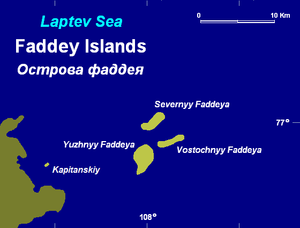
Faddey Islands
Encyclopedia
Tundra
In physical geography, tundra is a biome where the tree growth is hindered by low temperatures and short growing seasons. The term tundra comes through Russian тундра from the Kildin Sami word tūndâr "uplands," "treeless mountain tract." There are three types of tundra: Arctic tundra, alpine...
vegetation, shingle
Slate
Slate is a fine-grained, foliated, homogeneous metamorphic rock derived from an original shale-type sedimentary rock composed of clay or volcanic ash through low-grade regional metamorphism. The result is a foliated rock in which the foliation may not correspond to the original sedimentary layering...
and ice. It is located in the Laptev Sea
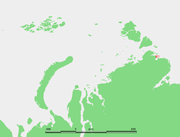
Laptev Sea
The Laptev Sea is a marginal sea of the Arctic Ocean. It is located between the northern coast of Siberia, the Taimyr Peninsula, Severnaya Zemlya and the New Siberian Islands. Its northern boundary passes from the Arctic Cape to a point with co-ordinates of 79°N and 139°E, and ends at the Anisiy...
coastal region, off Faddey Bay
Faddey Bay
The Faddey Bay is a gulf in the Laptev Sea on the eastern coast of the Taymyr Peninsula. It measures about 47 km from its innermost point in the southwest, the delta of the Pregradnaya River, to its broadest opening to the sea in the northeast...
(залив Фаддея) in the coast of Siberia
Siberia
Siberia is an extensive region constituting almost all of Northern Asia. Comprising the central and eastern portion of the Russian Federation, it was part of the Soviet Union from its beginning, as its predecessor states, the Tsardom of Russia and the Russian Empire, conquered it during the 16th...
, east of the Taymyr Peninsula
Taymyr Peninsula
The Taymyr Peninsula is a peninsula in the Far North of Russia, in the Siberian Federal District, that forms the northernmost part of mainland Eurasia and Asia...
.
The Main islands are:
- Ostrov Faddeyya-Severnyy, latitude 76° 59' N and longitude 108° 02’ E.
- Ostrov Faddeyya-Vostochnyy, latitude 76° 58' N and longitude 108° 07’ E.
- Ostrov Faddeyya-Yuzhnyy, latitude 76° 53' N and longitude 107° 58’ E.
- Ostrov Kapitanskiy, a smaller island, located off the main cluster and closer to the shore, latitude 76° 56' N and longitude 107° 27’ E.
The sea around these Islands is covered with fast ice in the winter and the climate is severe. The surrounding sea is obstructed by pack ice even in the summer.
The Faddey Islands were named after Russian explorer Fabian Gottlieb von Bellingshausen
Fabian Gottlieb von Bellingshausen
Fabian Gottlieb Thaddeus von Bellingshausen was an officer in the Imperial Russian Navy, cartographer and explorer, who ultimately rose to the rank of Admiral...
, which is "Faddey Faddeyevich Bellinsgauzen" in Russian.
This island group belongs to the Krasnoyarsk Krai
Krasnoyarsk Krai
Krasnoyarsk Krai is a federal subject of Russia . It is the second largest federal subject after the Sakha Republic, and Russia's largest krai, occupying an area of , which is 13% of the country's total territory. The administrative center of the krai is the city of Krasnoyarsk...
administrative division of Russia
Russia
Russia or , officially known as both Russia and the Russian Federation , is a country in northern Eurasia. It is a federal semi-presidential republic, comprising 83 federal subjects...
.
History
Ancient stone implements, probably shaped by man, were found on the Faddey Islands and were studied by the Russian archaeologist A.P. Okladnikov, an expert in the ancient cultures of Siberia and the Pacific Basin.In 1940-41 Soviet hydrographers found the remains of people, money, weapons and other items on these islands and in the nearby coast of the Simsa Bay
Simsa Bay
The Simsa Bay or Bay of Sims is a gulf in the Laptev Sea on the coast of the Taymyr Peninsula. It measures about 40 km from the mouth of the Gol'tsovaya River in the west to its broadest opening to the sea in the east. Its average width is 14 km.The cluster of islands deep inside the bay...
. Apparently these were traces of an expedition undertaken by Akaky and Ivan Muromets in the early 17th century.
A.P.Okladnikov, who studied these findings in 1945, supposed that the people went there from the west, from the Yenisei River (Historical monument…, 1945).
However, in the 1980s hydrographer V.A.Troitsky put forward a different theory. According to his point of view the deceased seafarers tried to sail by sea from the Khatanga Gulf
Khatanga Gulf
The Khatanga Gulf or Khatanga Bay is a large tidal estuary in the Laptev Sea. It is relatively narrow, its length being 220 km with a maximum width of 54 km....
to the mouth of the Yenisei on two ships in order to load furs (Troitsky, 1991). But the first ship was crushed by ice in the area of the Faddey Islands. Even though the crew were able to reach the land, none of them managed to survive. The second ship reached the Simsa Bay, where the crew built a house in order to leave three ill people there. Then the ship made its way to the south, and four people seem to have been able to reach populated places.
See also
- Laptev SeaLaptev SeaThe Laptev Sea is a marginal sea of the Arctic Ocean. It is located between the northern coast of Siberia, the Taimyr Peninsula, Severnaya Zemlya and the New Siberian Islands. Its northern boundary passes from the Arctic Cape to a point with co-ordinates of 79°N and 139°E, and ends at the Anisiy...
- Vasili PronchishchevVasili PronchishchevVasili Vasilyevich Pronchishchev was a Russian explorer.In 1718, Vasili Pronchishchev graduated from Moscow School of Mathematics and Navigation and was promoted to naval cadet...