

European route E10
Encyclopedia

European route E 10 is a road part of the International E-road network
International E-road network
The international E-road network is a numbering system for roads in Europe developed by the United Nations Economic Commission for Europe . The network is numbered from E 1 up and its roads cross national borders...
. It begins in Å
Å, Moskenes
-Overview:Å is traditionally a fishing village, specialising in stockfish, but now also features tourism.The town contains the Lofoten Stockfish Museum and the Norwegian Fishing Village Museum....
, Norway
Norway
Norway , officially the Kingdom of Norway, is a Nordic unitary constitutional monarchy whose territory comprises the western portion of the Scandinavian Peninsula, Jan Mayen, and the Arctic archipelago of Svalbard and Bouvet Island. Norway has a total area of and a population of about 4.9 million...
and ends in Luleå
Luleå
- Transportation :Local buses are run by .A passenger train service is available from Luleå Centralstation on Sweden's national SJ railway service northbound to Narvik on the Norwegian coast, or southbound to Stockholm. See Rail transport in Sweden....
, Sweden
Sweden
Sweden , officially the Kingdom of Sweden , is a Nordic country on the Scandinavian Peninsula in Northern Europe. Sweden borders with Norway and Finland and is connected to Denmark by a bridge-tunnel across the Öresund....
. The road is about 850 km (530 mi) in length. The Norwegian part of the road is also named Kong Olav Vs vei (King Olav V's road).
The road follows the route Å
Å, Moskenes
-Overview:Å is traditionally a fishing village, specialising in stockfish, but now also features tourism.The town contains the Lofoten Stockfish Museum and the Norwegian Fishing Village Museum....
– Leknes
Leknes
is a town and administrative centre of municipality Vestvågøy in the county of Nordland in North Norway. The town is situated in the geographical middle of Lofoten, approximately 68 km west of Svolvær and 65 km east of Å...
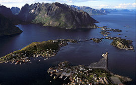
– Svolvær
Svolvær
-Communications:Parts of the town is built on small islands connected by bridges. There is a regional airport near the town, Svolvær Airport, Helle, and Svolvær is a port of call for Hurtigruten. There is a ferry connection Svolvær to Skutvik in Hamarøy, and express boat connections to Bodø...
– Gullesfjordbotn – Evenes
Evenes
Evenes is a municipality in Nordland county, Norway. It is part of the Ofoten region. The administrative centre of the municipality is the village of Bogen.The old municipality of Ofoten was split into Evenes and Ankenes on 1 January 1884...
– Bjerkvik
Bjerkvik
Bjerkvik is a village in the municipality of Narvik, Norway. Its population is 1,220. Bjerkvik is located at the head of Herjangsfjorden, an arm of Ofotfjord in the northeastern corner of Nordland county. There is less than 20 km to the border with Troms...
– Kiruna
Kiruna
Kiruna is the northernmost city in Sweden, situated in Lapland province, with 18,154 inhabitants in 2005. It is the seat of Kiruna Municipality Kiruna (Northern Sami: Giron, Finnish: Kiiruna) is the northernmost city in Sweden, situated in Lapland province, with 18,154 inhabitants in 2005. It is...
– Töre
Töre
Töre is a locality situated in Kalix Municipality, Norrbotten County, Sweden with 1,146 inhabitants in 2005.Its harbour is the northernmost of the Bothnian Bay that is accessible to commercial vessels. The European route E10 passes through Töre.- References :...
– Luleå
Luleå
- Transportation :Local buses are run by .A passenger train service is available from Luleå Centralstation on Sweden's national SJ railway service northbound to Narvik on the Norwegian coast, or southbound to Stockholm. See Rail transport in Sweden....
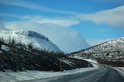
The entire road is paved and two-lane. It has a 90 or 110 kilometre per hour speed limit in Sweden, and is usually 7-8 meters wide, enough to make encounters between heavy vehicles trouble-free. In Norway the road is much more twisting than in Sweden, and around 6-7,5 m wide usually with a speed limit of 80 kilometre per hour. New sections have been built 7.5 m (25 ft) wide the last 15 years, but there are several much narrower parts left. 6 m (20 ft) width makes encounters between heavy vehicles tight. The last 50 km near Å the road is mostly less than 6 m (19.7 ft) wide, often 5 m (16.4 ft). Buses and caravans should avoid driving here, but many of them do so anyway.
The name E 10 was given in 1992. Before 1985, E 10 was the name of the road Paris-Brussels-Amsterdam-Groningen. The road between Narvik and Kiruna was finished in 1984, before that, no road existed at all directly between the two cities; the only way to travel between them was by train (with passenger services only three times a day), or by a large detour through Finland. In 2007, the road near Lofoten was shortened by about 30 km, and the ferry-service was bypassed for E10, with the opening of Lofast, which is a new road between Fiskebøl and Gullesfjordbotn. At the end of 2007, the E 10 has 18 tunnels totalling 20.4 km (12.7 mi), all in Norway.