
European Watershed
Encyclopedia
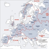
The European Watershed is the line which divides the drainage basin
s of the major rivers of Germany
: the Rhine, which originates in the Swiss Alps
and empties into the North Sea
via the Netherlands
, and the Danube
, which originates in the Black Forest
and flows eastward emptying into the Black Sea
.
The watershed is not a clearly defined divide
. Tectonics
, especially in the area that is now the Upper Rhine Plain
, created River Rhine. As its headward erosion
is much stronger than that of the much older River Danube (see the upper river geology) (due to the Rhine’s gravity on its much shorter way to the North Sea), the Rhine and its tributaries intrude deeper into phreatic zone
s of the Swabian Karst
and even capture the upper Danube and its surface tributaries.
It is expected that the Danube's upper course will one day disappear entirely in favour of the Rhine ("stream capture").
Drainage basin
A drainage basin is an extent or an area of land where surface water from rain and melting snow or ice converges to a single point, usually the exit of the basin, where the waters join another waterbody, such as a river, lake, reservoir, estuary, wetland, sea, or ocean...
s of the major rivers of Germany
Germany
Germany , officially the Federal Republic of Germany , is a federal parliamentary republic in Europe. The country consists of 16 states while the capital and largest city is Berlin. Germany covers an area of 357,021 km2 and has a largely temperate seasonal climate...
: the Rhine, which originates in the Swiss Alps
Swiss Alps
The Swiss Alps are the portion of the Alps mountain range that lies within Switzerland. Because of their central position within the entire Alpine range, they are also known as the Central Alps....
and empties into the North Sea
North Sea
In the southwest, beyond the Straits of Dover, the North Sea becomes the English Channel connecting to the Atlantic Ocean. In the east, it connects to the Baltic Sea via the Skagerrak and Kattegat, narrow straits that separate Denmark from Norway and Sweden respectively...
via the Netherlands
Netherlands
The Netherlands is a constituent country of the Kingdom of the Netherlands, located mainly in North-West Europe and with several islands in the Caribbean. Mainland Netherlands borders the North Sea to the north and west, Belgium to the south, and Germany to the east, and shares maritime borders...
, and the Danube
Danube
The Danube is a river in the Central Europe and the Europe's second longest river after the Volga. It is classified as an international waterway....
, which originates in the Black Forest
Black Forest
The Black Forest is a wooded mountain range in Baden-Württemberg, southwestern Germany. It is bordered by the Rhine valley to the west and south. The highest peak is the Feldberg with an elevation of 1,493 metres ....
and flows eastward emptying into the Black Sea
Black Sea
The Black Sea is bounded by Europe, Anatolia and the Caucasus and is ultimately connected to the Atlantic Ocean via the Mediterranean and the Aegean seas and various straits. The Bosphorus strait connects it to the Sea of Marmara, and the strait of the Dardanelles connects that sea to the Aegean...
.
The watershed is not a clearly defined divide
Water divide
A drainage divide, water divide, divide or watershed is the line separating neighbouring drainage basins...
. Tectonics
Tectonics
Tectonics is a field of study within geology concerned generally with the structures within the lithosphere of the Earth and particularly with the forces and movements that have operated in a region to create these structures.Tectonics is concerned with the orogenies and tectonic development of...
, especially in the area that is now the Upper Rhine Plain
Upper Rhine Plain
The Upper Rhine Plain, Rhine Rift Valley or Upper Rhine Graben is a major rift, straddling the border between France and Germany. It forms part of the European Cenozoic Rift System, which extends across central Europe...
, created River Rhine. As its headward erosion
Headward erosion
Headward erosion is a fluvial process of erosion that lengthens a stream, a valley or a gully at its head and also enlarges its drainage basin. The stream erodes away at the rock and soil at its headwaters in the opposite direction that it flows. Once a stream has begun to cut back, the erosion is...
is much stronger than that of the much older River Danube (see the upper river geology) (due to the Rhine’s gravity on its much shorter way to the North Sea), the Rhine and its tributaries intrude deeper into phreatic zone
Phreatic zone
The phreatic zone, or zone of saturation, is the area in an aquifer, below the water table, in which relatively all pores and fractures are saturated with water. The phreatic zone may fluctuate with changes of season and during wet and dry periods....
s of the Swabian Karst
Karst topography
Karst topography is a geologic formation shaped by the dissolution of a layer or layers of soluble bedrock, usually carbonate rock such as limestone or dolomite, but has also been documented for weathering resistant rocks like quartzite given the right conditions.Due to subterranean drainage, there...
and even capture the upper Danube and its surface tributaries.
It is expected that the Danube's upper course will one day disappear entirely in favour of the Rhine ("stream capture").
See also
- Drainage basinDrainage basinA drainage basin is an extent or an area of land where surface water from rain and melting snow or ice converges to a single point, usually the exit of the basin, where the waters join another waterbody, such as a river, lake, reservoir, estuary, wetland, sea, or ocean...
- Drainage divide
- Category: Watersheds