

Eurasian Steppe
Encyclopedia
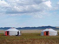
Steppe
In physical geography, steppe is an ecoregion, in the montane grasslands and shrublands and temperate grasslands, savannas, and shrublands biomes, characterized by grassland plains without trees apart from those near rivers and lakes...
ecoregion
Ecoregion
An ecoregion , sometimes called a bioregion, is an ecologically and geographically defined area that is smaller than an ecozone and larger than an ecosystem. Ecoregions cover relatively large areas of land or water, and contain characteristic, geographically distinct assemblages of natural...
of Eurasia
Eurasia
Eurasia is a continent or supercontinent comprising the traditional continents of Europe and Asia ; covering about 52,990,000 km2 or about 10.6% of the Earth's surface located primarily in the eastern and northern hemispheres...
in the Temperate grasslands, savannas, and shrublands
Temperate grasslands, savannas, and shrublands
Temperate grasslands, savannas, and shrublands is a terrestrial biome whose predominant vegetation consists of grasses and/or shrubs. The climate is temperate and semi-arid to semi-humid....
Biome
Biome
Biomes are climatically and geographically defined as similar climatic conditions on the Earth, such as communities of plants, animals, and soil organisms, and are often referred to as ecosystems. Some parts of the earth have more or less the same kind of abiotic and biotic factors spread over a...
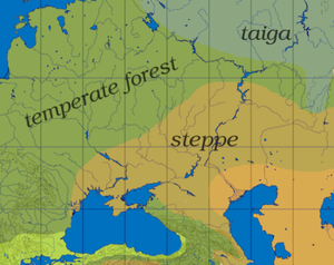
. It stretches from Hungary to Mongolia. The steppe has connected Europe
Europe
Europe is, by convention, one of the world's seven continents. Comprising the westernmost peninsula of Eurasia, Europe is generally 'divided' from Asia to its east by the watershed divides of the Ural and Caucasus Mountains, the Ural River, the Caspian and Black Seas, and the waterways connecting...
, Central Asia
Central Asia
Central Asia is a core region of the Asian continent from the Caspian Sea in the west, China in the east, Afghanistan in the south, and Russia in the north...
, China
China
Chinese civilization may refer to:* China for more general discussion of the country.* Chinese culture* Greater China, the transnational community of ethnic Chinese.* History of China* Sinosphere, the area historically affected by Chinese culture...
, South Asia
South Asia
South Asia, also known as Southern Asia, is the southern region of the Asian continent, which comprises the sub-Himalayan countries and, for some authorities , also includes the adjoining countries to the west and the east...
, and the Middle East
Middle East
The Middle East is a region that encompasses Western Asia and Northern Africa. It is often used as a synonym for Near East, in opposition to Far East...
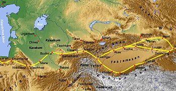
economically, politically, and culturally through overland trade routes, most notably the Silk Road
Silk Road
The Silk Road or Silk Route refers to a historical network of interlinking trade routes across the Afro-Eurasian landmass that connected East, South, and Western Asia with the Mediterranean and European world, as well as parts of North and East Africa...
during Antiquity
Classical antiquity
Classical antiquity is a broad term for a long period of cultural history centered on the Mediterranean Sea, comprising the interlocking civilizations of ancient Greece and ancient Rome, collectively known as the Greco-Roman world...
and the Middle Ages
Middle Ages
The Middle Ages is a periodization of European history from the 5th century to the 15th century. The Middle Ages follows the fall of the Western Roman Empire in 476 and precedes the Early Modern Era. It is the middle period of a three-period division of Western history: Classic, Medieval and Modern...
, and the Eurasian Land Bridge
Eurasian Land Bridge
The Eurasian Land Bridge, sometimes called the New Silk Road, is a term used to describe the rail transport route for moving freight and passengers overland from Pacific seaports in Siberia and China to seaports in Europe...
in the modern era.
Ecoregions
The World Wildlife Fund divides the Euro-Asian Steppe's temperate grasslands, savannas, and shrublands into a number of ecoregionEcoregion
An ecoregion , sometimes called a bioregion, is an ecologically and geographically defined area that is smaller than an ecozone and larger than an ecosystem. Ecoregions cover relatively large areas of land or water, and contain characteristic, geographically distinct assemblages of natural...
s, distinguished by elevation, climate, rainfall, and other characteristics, and home to distinct animal and plant communities and species, and distinct habitat
Habitat
* Habitat , a place where a species lives and grows*Human habitat, a place where humans live, work or play** Space habitat, a space station intended as a permanent settlement...
ecosystem
Ecosystem
An ecosystem is a biological environment consisting of all the organisms living in a particular area, as well as all the nonliving , physical components of the environment with which the organisms interact, such as air, soil, water and sunlight....
s.
- Alai-Western Tian Shan steppe (Kazakhstan, Tajikistan, Uzbekistan)
- Altai steppe and semi-desert (Kazakhstan)
- Daurian forest steppe (China, Mongolia, Russia)
- Emin Valley steppe (China, Kazakhstan)
- Kazakh forest steppe (Kazakhstan, Russia)
- Kazakh steppeKazakh SteppeThe Kazakh Steppe or Kirghiz Steppe ecoregion, of the Palearctic Temperate grasslands, savannas, and shrublands Biome, is a vast region of open grassland in northern Kazakhstan and adjacent portions of Russia, extending to the east of the Pontic steppe and to the west of the Emin Valley steppe,...
(Kazakhstan, Russia) - Kazakh upland (Kazakhstan)
- Mongolian-Manchurian grasslandMongolian-Manchurian grasslandThe Mongolian-Manchurian grassland ecoregion, also known as the Mongolian-Manchurian steppe, in the temperate grassland Biome, is found in Mongolia, the Chinese Autonomous region of Inner Mongolia and northeastern China.-Setting:...
(China, Mongolia, Russia) - Pontic steppe (Moldova, Romania, Russia, Ukraine)
- Sayan Intermontane steppe (Russia)
- Selenge-Orkhon forest steppe (Mongolia, Russia)
- South Siberian forest steppe (Russia)
- Tian Shan foothill arid steppe (China, Kazakhstan, Kyrgyzstan)
Divisions

Siberia
Siberia is an extensive region constituting almost all of Northern Asia. Comprising the central and eastern portion of the Russian Federation, it was part of the Soviet Union from its beginning, as its predecessor states, the Tsardom of Russia and the Russian Empire, conquered it during the 16th...
. There is no clear southern boundary although the land becomes increasingly dry as one moves south. The steppe narrows at two points, dividing it into three major parts.
Ural-Caspian
- The Ural MountainsUral MountainsThe Ural Mountains , or simply the Urals, are a mountain range that runs approximately from north to south through western Russia, from the coast of the Arctic Ocean to the Ural River and northwestern Kazakhstan. Their eastern side is usually considered the natural boundary between Europe and Asia...
extend south to a point about 400 miles northeast of the Caspian SeaCaspian SeaThe Caspian Sea is the largest enclosed body of water on Earth by area, variously classed as the world's largest lake or a full-fledged sea. The sea has a surface area of and a volume of...
. This is not a major barrier to movement, but the area near the Caspian is quite dry.
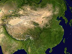
Xinjiang
- XinjiangXinjiangXinjiang is an autonomous region of the People's Republic of China. It is the largest Chinese administrative division and spans over 1.6 million km2...
: On the east side of the former Sino-Soviet border mountains extend northeast almost to the forest zone. The northern part is DzungariaDzungariaDzungaria, also called Zungaria, is a geographical region in northwest China corresponding to the northern half of Xinjiang. It covers approximately , lying mostly within Xinjiang, and extending into western Mongolia and eastern Kazakhstan...
which is bounded by the Tarbagatai MountainsTarbagatai MountainsTarbagatai Mountains is a range of mountains located in the north-western parts of Xinjiang, China and East Kazakhstan....
on the west and the Mongolian Altai Mountains on the east, neither of which is a significant barrier. Dzungaria has good grassland around the edges and a central desert. It often behaved as a westward extension of Mongolia. To the south and west of Dzungaria, and separated from it by the Tianshan Mountains, is an area about twice the size of Dzungaria, the oval Tarim BasinTarim BasinThe Tarim Basin is a large endorheic basin occupying an area of about . It is located in the Xinjiang Uyghur Autonomous Region in China's far west. Its northern boundary is the Tian Shan mountain range and its southern is the Kunlun Mountains on the northern edge of the Tibetan Plateau. The...
in the Xinjiang Uyghur Autonomous Region in China's far west. The Tarim Basin is too dry to support even a nomadic population, but around its edges rivers flow down from the mountains giving rise to a ring of cities which lived by irrigation agriculture and east-west trade. The Tarim Basin formed an island of near civilization in the center of the steppe. To the south, the Kunlun MountainsKunlun MountainsThe Kunlun Mountains are one of the longest mountain chains in Asia, extending more than 3,000 km. In the broadest sense, it forms the northern edge of the Tibetan Plateau south of the Tarim Basin and the Gansu Corridor and continues east south of the Wei River to end at the North China Plain.The...
separate the Tarim Basin from the thinly-peopled Tibetan PlateauTibetan PlateauThe Tibetan Plateau , also known as the Qinghai–Tibetan Plateau is a vast, elevated plateau in Central Asia covering most of the Tibet Autonomous Region and Qinghai, in addition to smaller portions of western Sichuan, southwestern Gansu, and northern Yunnan in Western China and Ladakh in...
. The south of this plateau along the Himalaya Mountains was the main center of Tibetan population and civilization. To the southwest the Pamir MountainsPamir MountainsThe Pamir Mountains are a mountain range in Central Asia formed by the junction or knot of the Himalayas, Tian Shan, Karakoram, Kunlun, and Hindu Kush ranges. They are among the world’s highest mountains and since Victorian times they have been known as the "Roof of the World" a probable...
merge into the Hindu KushHindu KushThe Hindu Kush is an mountain range that stretches between central Afghanistan and northern Pakistan. The highest point in the Hindu Kush is Tirich Mir in the Chitral region of Khyber-Pakhtunkhwa, Pakistan.It is the westernmost extension of the Pamir Mountains, the Karakoram Range, and is a...
and the Himalaya Mountains.
Russian Steppe
- The Russian Steppe begins near the mouth of the DanubeDanubeThe Danube is a river in the Central Europe and the Europe's second longest river after the Volga. It is classified as an international waterway....
and extends northeast almost to KazanKazanKazan is the capital and largest city of the Republic of Tatarstan, Russia. With a population of 1,143,546 , it is the eighth most populous city in Russia. Kazan lies at the confluence of the Volga and Kazanka Rivers in European Russia. In April 2009, the Russian Patent Office granted Kazan the...
and then southeast to the southern tip of the Ural MountainsUral MountainsThe Ural Mountains , or simply the Urals, are a mountain range that runs approximately from north to south through western Russia, from the coast of the Arctic Ocean to the Ural River and northwestern Kazakhstan. Their eastern side is usually considered the natural boundary between Europe and Asia...
. Its northern edge was a broad band of Forest-steppe which has now been obliterated by the conversion of the whole area to agriculture. In the southeast the Pontic-Caspian steppePontic-Caspian steppeThe Pontic-Caspian steppe is the vast steppeland stretching from the north of the Black Sea as far as the east of the Caspian Sea, from western Ukraine across the Southern Federal District and the Volga Federal District of Russia to western Kazakhstan,...
extends between the Black SeaBlack SeaThe Black Sea is bounded by Europe, Anatolia and the Caucasus and is ultimately connected to the Atlantic Ocean via the Mediterranean and the Aegean seas and various straits. The Bosphorus strait connects it to the Sea of Marmara, and the strait of the Dardanelles connects that sea to the Aegean...
and Caspian SeaCaspian SeaThe Caspian Sea is the largest enclosed body of water on Earth by area, variously classed as the world's largest lake or a full-fledged sea. The sea has a surface area of and a volume of...
to the Caucasus MountainsCaucasus MountainsThe Caucasus Mountains is a mountain system in Eurasia between the Black Sea and the Caspian Sea in the Caucasus region .The Caucasus Mountains includes:* the Greater Caucasus Mountain Range and* the Lesser Caucasus Mountains....
. In the west, the Great Hungarian PlainGreat Hungarian PlainThe Great Hungarian Plain is a plain occupying the southern and eastern part of Hungary, some parts of the Eastern Slovak Lowland, southwestern Ukraine, the Transcarpathian Lowland , western Romania , northern Serbia , and eastern Croatia...
is an island of steppe separated from the main steppe by the mountains of TransylvaniaTransylvaniaTransylvania is a historical region in the central part of Romania. Bounded on the east and south by the Carpathian mountain range, historical Transylvania extended in the west to the Apuseni Mountains; however, the term sometimes encompasses not only Transylvania proper, but also the historical...
. North of the Black Sea, the CrimeaCrimeaCrimea , or the Autonomous Republic of Crimea , is a sub-national unit, an autonomous republic, of Ukraine. It is located on the northern coast of the Black Sea, occupying a peninsula of the same name...
n peninsula has some interior steppe and ports on the south coast which link the Russian steppe to the civilizations of the Mediterranean basin.
Kazakh Steppe
- The Kazakh SteppeKazakh SteppeThe Kazakh Steppe or Kirghiz Steppe ecoregion, of the Palearctic Temperate grasslands, savannas, and shrublands Biome, is a vast region of open grassland in northern Kazakhstan and adjacent portions of Russia, extending to the east of the Pontic steppe and to the west of the Emin Valley steppe,...
proper extends from the Urals to Dzungaria. To the south it grades off into semi-desert and desert which is interrupted by two great rivers, the Amu DaryaAmu DaryaThe Amu Darya , also called Oxus and Amu River, is a major river in Central Asia. It is formed by the junction of the Vakhsh and Panj rivers...
(Oxus) and Syr DaryaSyr DaryaThe Syr Darya , also transliterated Syrdarya or Sirdaryo, is a river in Central Asia, sometimes known as the Jaxartes or Yaxartes from its Ancient Greek name . The Greek name is derived from Old Persian, Yakhsha Arta , a reference to the color of the river's water...
(Jaxartes) which flow northwest into the Aral SeaAral SeaThe Aral Sea was a lake that lay between Kazakhstan in the north and Karakalpakstan, an autonomous region of Uzbekistan, in the south...
and provide irrigation agriculture. In the southeast is the densely populated Fergana ValleyFergana ValleyThe Fergana Valley or Farghana Valley is a region in Central Asia spreading across eastern Uzbekistan, Kyrgyzstan and Tajikistan. Divided across three subdivisions of the former Soviet Union, the valley is ethnically diverse, and in the early 21st century was the scene of ethnic conflict...
and west of it the great oasis cities of TashkentTashkentTashkent is the capital of Uzbekistan and of the Tashkent Province. The officially registered population of the city in 2008 was about 2.2 million. Unofficial sources estimate the actual population may be as much as 4.45 million.-Early Islamic History:...
, SamarkandSamarkandAlthough a Persian-speaking region, it was not united politically with Iran most of the times between the disintegration of the Seleucid Empire and the Arab conquest . In the 6th century it was within the domain of the Turkic kingdom of the Göktürks.At the start of the 8th century Samarkand came...
and BukharaBukharaBukhara , from the Soghdian βuxārak , is the capital of the Bukhara Province of Uzbekistan. The nation's fifth-largest city, it has a population of 263,400 . The region around Bukhara has been inhabited for at least five millennia, and the city has existed for half that time...
along the Zarafshan River. The southern area has a complex history (see Central AsiaCentral AsiaCentral Asia is a core region of the Asian continent from the Caspian Sea in the west, China in the east, Afghanistan in the south, and Russia in the north...
and Greater IranGreater IranGreater Iran refers to the regions that have significant Iranian cultural influence. It roughly corresponds to the territory on the Iranian plateau and its bordering plains, stretching from Iraq, the Caucasus, and Turkey in the west to the Indus River in the east...
) while in the north the Kazakh Steppe proper was relatively isolated from the main currents of history.
Mongol Steppe
- The Mongol Steppe includes both the Outer MongoliaOuter MongoliaOuter Mongolia was a territory of the Qing Dynasty = the Manchu Empire. Its area was roughly equivalent to that of the modern state of Mongolia, which is sometimes informally called "Outer Mongolia" today...
that we see on maps and also modern Chinese province of Inner MongoliaInner MongoliaInner Mongolia is an autonomous region of the People's Republic of China, located in the northern region of the country. Inner Mongolia shares an international border with the countries of Mongolia and the Russian Federation...
. The two are separated by a relatively dry area marked by the Gobi DesertGobi DesertThe Gobi is a large desert region in Asia. It covers parts of northern and northwestern China, and of southern Mongolia. The desert basins of the Gobi are bounded by the Altai Mountains and the grasslands and steppes of Mongolia on the north, by the Hexi Corridor and Tibetan Plateau to the...
. South of Mongolia is the GansuGansu' is a province located in the northwest of the People's Republic of China.It lies between the Tibetan and Huangtu plateaus, and borders Mongolia, Inner Mongolia, and Ningxia to the north, Xinjiang and Qinghai to the west, Sichuan to the south, and Shaanxi to the east...
or Hexi CorridorHexi CorridorHexi Corridor or Gansu Corridor refers to the historical route in Gansu province of China. As part of the Northern Silk Road running northwest from the bank of the Yellow River, it was the most important route from North China to the Tarim Basin and Central Asia for traders and the military. The...
, a belt of moderately dense population that connects China properChina properChina proper or Eighteen Provinces was a term used by Western writers on the Qing Dynasty to express a distinction between the core and frontier regions of China. There is no fixed extent for China proper, as many administrative, cultural, and linguistic shifts have occurred in Chinese history...
with the Tarim Basin. The Gansu Corridor was the main route of the Silk RoadSilk RoadThe Silk Road or Silk Route refers to a historical network of interlinking trade routes across the Afro-Eurasian landmass that connected East, South, and Western Asia with the Mediterranean and European world, as well as parts of North and East Africa...
. When Chinese dynasties were strong they would extend a thin finger of power along the Gansu corridor toward the Tarim Basin. To the southwest the Qilian Mountains separate the Gansu Corridor from the Tibetan PlateauTibetan PlateauThe Tibetan Plateau , also known as the Qinghai–Tibetan Plateau is a vast, elevated plateau in Central Asia covering most of the Tibet Autonomous Region and Qinghai, in addition to smaller portions of western Sichuan, southwestern Gansu, and northern Yunnan in Western China and Ladakh in...
. To the south is a region of hills and mountains, and to the southeast, the Central China Plain.
Manchuria
- "ManchuriaManchuriaManchuria is a historical name given to a large geographic region in northeast Asia. Depending on the definition of its extent, Manchuria usually falls entirely within the People's Republic of China, or is sometimes divided between China and Russia. The region is commonly referred to as Northeast...
" is a special case. Westerners tend to think of Manchuria as including not only modern Northeast ChinaNortheast ChinaNortheast China, historically known in English as Manchuria, is a geographical region of China, consisting of the three provinces of Liaoning, Jilin and Heilongjiang. The region is sometimes called the Three Northeast Provinces...
but also China west of the Greater KhinganGreater KhinganThe Greater Khingan Range , also called the Greater Hing'an Range or Greater Hinggan Range, is a volcanic mountain range in the northeastern part of the People's Republic of China. The range extends roughly 1,200 km from north to south, narrowing towards the south...
Mountains, which is in fact a part of Inner Mongolia. The Pacific coast and the northern part of Greater ManchuriaOuter ManchuriaOuter Manchuria , is the territory ceded by China to Russia in the Treaty of Aigun in 1858 and the Treaty of Peking in 1860. . The northern part of the area was also in dispute between 1643 and 1689...
were only annexed by Russia in 1860. The Southeastern quarter of it, including the Yalu riverYalu RiverThe Yalu River or the Amnok River is a river on the border between North Korea and the People's Republic of China....
valley and the eastern portion of modern-day JilinJilinJilin , is a province of the People's Republic of China located in the northeastern part of the country. Jilin borders North Korea and Russia to the east, Heilongjiang to the north, Liaoning to the south, and Inner Mongolia to the west...
used to be controlled by ancient Korean dynasties such as GoguryeoGoguryeoGoguryeo or Koguryŏ was an ancient Korean kingdom located in present day northern and central parts of the Korean Peninsula, southern Manchuria, and southern Russian Maritime province....
and BalhaeBalhaeBalhae was a Manchurian kingdom established after the fall of Goguryeo. After Goguryeo's capital and southern territories fell to Unified Silla, Dae Jo-yeong, a Mohe general, whose father was Dae Jung-sang, established Jin , later called Balhae.Balhae occupied southern parts of Manchuria and...
. In the south, the Liaotung Peninsula has been Chinese for at least 1,000 years, since the demise of Goguryeo. It is connected to China ProperChina properChina proper or Eighteen Provinces was a term used by Western writers on the Qing Dynasty to express a distinction between the core and frontier regions of China. There is no fixed extent for China proper, as many administrative, cultural, and linguistic shifts have occurred in Chinese history...
by a narrow coastal strip, the ShanhaiguanShanhaiguan DistrictShanhaiguan District is a district of the city of Qinhuangdao, Hebei province, People's Republic of China, named after the pass of the Great Wall within the district, Shanhai Pass...
or 'mountain-sea-gate'. South of the Khingan Mountains and north of the Taihang MountainsTaihang MountainsThe Taihang Mountains are a Chinese mountain range running down the eastern edge of the Loess Plateau in Henan, Shanxi and Hebei provinces. The range extends over 400 km from north to south and has an average elevation of 1,500 to 2,000 meters. The principal peak is Xiao Wutaishan...
the Liao Xi steppe extends from Inner Mongolia into Manchuria. The central area of forest-steppe was inhabited by pastoral and agricultural peoples. To the north and east was a thin population of hunting tribes of the Siberian type. For half of the last two thousand years north China was ruled by dynasties originating in Manchuria. In the last 200 years the whole area has become populated by Han ChineseHan ChineseHan Chinese are an ethnic group native to China and are the largest single ethnic group in the world.Han Chinese constitute about 92% of the population of the People's Republic of China , 98% of the population of the Republic of China , 78% of the population of Singapore, and about 20% of the...
.
Language, Religion, Trade and Warfare
Trade: The major centers of population and high culture in Eurasia are Europe, the Middle East, India and China. For some purposes it is useful to treat Greater IranGreater Iran
Greater Iran refers to the regions that have significant Iranian cultural influence. It roughly corresponds to the territory on the Iranian plateau and its bordering plains, stretching from Iraq, the Caucasus, and Turkey in the west to the Indus River in the east...
as a separate region. With the exception of Europe and the Middle East, these regions are connected by the steppe. The Silk Road
Silk Road
The Silk Road or Silk Route refers to a historical network of interlinking trade routes across the Afro-Eurasian landmass that connected East, South, and Western Asia with the Mediterranean and European world, as well as parts of North and East Africa...
started in the Guanzhong
Guanzhong
Guanzhong , or Guanzhong Plain, is a historical region of China corresponding to the lower valley of the Wei River. It is called Guanzhong or 'within the passes' to distinguish it from 'Guandong' or 'east of the pass', that is, the North China Plain. The North China Plain is bordered on the west by...
region of China and ran west along the Gansu Corridor to the Tarim Basin. From there it went southwest to Greater Iran and turned southeast to India or west to the Middle East and Europe. A minor branch went northwest along the great rivers and north of the Caspian Sea to the Black Sea. When faced with a rich caravan the steppe nomads could either rob it, or tax it, or hire themselves out as guards. Economically these three forms of taxation or parasitism amounted to the same thing. Trade was usually most vigorous when a strong empire controlled the steppe and reduced the number of petty chieftains preying on trade. The silk road first became significant and Chinese silk began reaching the Roman Empire about the time that the Emperor Wu of Han
Emperor Wu of Han
Emperor Wu of Han , , personal name Liu Che , was the seventh emperor of the Han Dynasty of China, ruling from 141 BC to 87 BC. Emperor Wu is best remembered for the vast territorial expansion that occurred under his reign, as well as the strong and centralized Confucian state he organized...
pushed Chinese power west to the Tarim Basin.
Biologically the steppe population is Mongoloid in the east and from the Tarim Basin becomes increasingly Caucasoid as one moves west. The Kalmyks are an isolated Mongoloid population west of the Volga.
Language: On one hypothesis of the origin of the Indo-European
Indo-European
Indo-European may refer to:* Indo-European languages** Aryan race, a 19th century and early 20th century term for those peoples who are the native speakers of Indo-European languages...
languages, their common ancestor is thought to have originated on the Russian steppe. The Tocharians
Tocharians
The Tocharians were the Tocharian-speaking inhabitants of the Tarim Basin, making them the easternmost speakers of Indo-European languages in antiquity. They were known as, or at least closely related to, the Yuezhi of Chinese sources...
were an early branch of Indo-European in the Tarim Basin
Tarim Basin
The Tarim Basin is a large endorheic basin occupying an area of about . It is located in the Xinjiang Uyghur Autonomous Region in China's far west. Its northern boundary is the Tian Shan mountain range and its southern is the Kunlun Mountains on the northern edge of the Tibetan Plateau. The...
. At the beginning of written history the entire steppe population west of Dzungaria spoke Iranian languages
Iranian languages
The Iranian languages form a subfamily of the Indo-Iranian languages which in turn is a subgroup of Indo-European language family. They have been and are spoken by Iranian peoples....
. From about 500 AD the Turkic Languages
Turkic languages
The Turkic languages constitute a language family of at least thirty five languages, spoken by Turkic peoples across a vast area from Eastern Europe and the Mediterranean to Siberia and Western China, and are considered to be part of the proposed Altaic language family.Turkic languages are spoken...
replaced the Iranian languages first on the steppe and later in the oases north of Iran. The reasons for this are poorly understood. After 1077 a group of Turkic speakers pushed into Anatolia and founded the modern nation of Turkey. The Mongolic languages
Mongolic languages
The Mongolic languages are a group of languages spoken in East-Central Asia, mostly in Mongolia and surrounding areas plus in Kalmykia. The best-known member of this language family, Mongolian, is the primary language of most of the residents of Mongolia and the Mongolian residents of Inner...
are in Mongolia. In Manchuria one finds Tungusic languages
Tungusic languages
The Tungusic languages form a language family spoken in Eastern Siberia and Manchuria by Tungusic peoples. Many Tungusic languages are endangered, and the long-term future of the family is uncertain...
and some others.
Religion: If the Kurgan hypothesis
Kurgan hypothesis
The Kurgan hypothesis is one of the proposals about early Indo-European origins, which postulates that the people of an archaeological "Kurgan culture" in the Pontic steppe were the most likely speakers of the Proto-Indo-European language...
of Indo-European origins is accepted, then the earliest hypothesised steppe religion would have been the mythology of the Indo-Europeans
Proto-Indo-European religion
Proto-Indo-European religion is the hypothesized religion of the Proto-Indo-European peoples based on the existence of similarities among the deities, religious practices and mythologies of the Indo-European peoples. Reconstruction of the hypotheses below is based on linguistic evidence using the...
. Later, Tangriism was introduced by Turko-Mongol nomads. Nestorianism
Nestorianism
Nestorianism is a Christological doctrine advanced by Nestorius, Patriarch of Constantinople from 428–431. The doctrine, which was informed by Nestorius's studies under Theodore of Mopsuestia at the School of Antioch, emphasizes the disunion between the human and divine natures of Jesus...
and Manichaeism
Manichaeism
Manichaeism in Modern Persian Āyin e Māni; ) was one of the major Iranian Gnostic religions, originating in Sassanid Persia.Although most of the original writings of the founding prophet Mani have been lost, numerous translations and fragmentary texts have survived...
spread to the Tarim Basin and into China but they never became an established majority religion. Buddhism
Buddhism
Buddhism is a religion and philosophy encompassing a variety of traditions, beliefs and practices, largely based on teachings attributed to Siddhartha Gautama, commonly known as the Buddha . The Buddha lived and taught in the northeastern Indian subcontinent some time between the 6th and 4th...
spread from India north to the Tarim Basin and found a new home in China. By about 1400 the entire steppe west of Dzungaria had adopted Islam
Islam
Islam . The most common are and . : Arabic pronunciation varies regionally. The first vowel ranges from ~~. The second vowel ranges from ~~~...
. By about 1600 Islam was established in the Tarim Basin while Dzungaria and Mongolia had adopted Tibetan Buddhism
Tibetan Buddhism
Tibetan Buddhism is the body of Buddhist religious doctrine and institutions characteristic of Tibet and certain regions of the Himalayas, including northern Nepal, Bhutan, and India . It is the state religion of Bhutan...
.
Animals: There seems to be little information about steppe ecology before the coming of nomadic pastoralism
Nomadic pastoralism
Nomadic pastoralism is a form of agriculture where livestock are herded in order to find fresh pastures on which to graze following an irregular pattern of movement - in contrast with transhumance where seasonal pastures are fix. The herded livestock may include cattle, yaks, sheep, goats,...
. The primary animals raised were sheep and goats with fewer cattle than one might expect. Camels were used in the drier areas for transport as far west as Astrakhan. There were some Yaks along the edge of Tibet. The horse was used for transportation and warfare.
The Horse was first domesticated on the Russian or Kazakh steppe sometime before 3000 BC, but it took a long time for the Horse archer to develop and the process is not fully understood. The stirrup does not seem to have been completely developed until 300 AD. (see Stirrup
Stirrup
A stirrup is a light frame or ring that holds the foot of a rider, attached to the saddle by a strap, often called a stirrup leather. Stirrups are usually paired and are used to aid in mounting and as a support while using a riding animal...
, Saddle
Saddle
A saddle is a supportive structure for a rider or other load, fastened to an animal's back by a girth. The most common type is the equestrian saddle designed for a horse, but specialized saddles have been created for camels and other creatures...
, Composite Bow
Composite bow
A composite bow is a bow made from horn, wood, and sinew laminated together. The horn is on the belly, facing the archer, and sinew on the back of a wooden core. Sinew and horn will store more energy than wood for the same length of bow...
, Domestication of the horse
Domestication of the horse
There are a number of hypotheses on many of the key issues regarding the domestication of the horse. Although horses appeared in Paleolithic cave art as early as 30,000 BCE, these were truly wild horses and were probably hunted for meat. How and when horses became domesticated is disputed...
and related articles.)
Agriculture: The nomads would occasionally tolerate colonies of peasants on the steppe in the few areas where farming was possible. These were often captives who grew grain for their nomadic masters. Along the fringes there were areas that could be used for either plowland or grassland. These alternated between one and the other depending on the relative strength of the nomadic and agrarian heartlands. In the last few hundred years the Russian steppe and much of Inner Mongolia has fallen to the plow. The fact that most of the Russian steppe is not irrigated implies that it was held in grass due to the military strength of the nomads.
Warfare: There was a great deal of petty raiding all over the steppe. This is connected to the ease with which a defeated enemy's flocks can be driven away, which makes raiding profitable. In relation to sedentary societies, the horse gave the nomads the supreme advantage of mobility. Horsemen can raid a village and be gone with their loot before a land army can be gathered. When confronted with superior infantry, horsemen can simply ride away and regroup where there are no soldiers. Outside of Europe and parts of the Middle East, agrarian societies had difficulty raising a sufficient number of war horses and often had to buy them from their nomadic enemies. Nomads could not easily be pursued onto the steppe since the steppe could not easily support a land army. If the Chinese sent an army into Mongolia, the nomads would flee and come back when the Chinese ran out of supplies. But the steppe nomads were relatively few and their rulers had difficulty holding together enough clans and tribes to field a large army. Except for Ginghis Khan, they could not take walled cities. If they conquered an agricultural area they often lacked the skills to administer it. If they tried to hold agrarian land they gradually absorbed the higher civilization of their subjects, lost their barbarian skills and were either absorbed by their subjects or driven out.
Relations with Neighbors: Along the northern fringe the nomads would collect tribute from and blend with the forest tribes (see Khanate of Sibir, Buryats
Buryats
The Buryats or Buriyads , numbering approximately 436,000, are the largest ethnic minority group in Siberia and are mainly concentrated in their homeland, the Buryat Republic, a federal subject of Russia...
). From about 1240 to 1480 Russia paid tribute to the Golden Horde
Golden Horde
The Golden Horde was a Mongol and later Turkicized khanate that formed the north-western sector of the Mongol Empire...
. South of the Kazakh steppe the nomads blended with the sedentary population, partly because the Middle East and Iran have significant areas of steppe and pastoralism. There was a sharp cultural divide between Mongolia and China and almost constant warfare from the dawn of history until 1757. The nomads collected large amounts of tribute from the Chinese and several Chinese dynasties were of steppe origin. Perhaps because of the mixture of agriculture and pastoralism in Manchuria its inhabitants knew how to deal with both nomads and settled populations and were able to conquer much of northern China when both Chinese and Mongols were weak.