
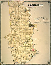
Etobicoke, Ontario
Encyclopedia
Etobicoke is a dissolved municipality located within the current city of Toronto
Toronto
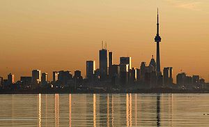
Toronto is the provincial capital of Ontario and the largest city in Canada. It is located in Southern Ontario on the northwestern shore of Lake Ontario. A relatively modern city, Toronto's history dates back to the late-18th century, when its land was first purchased by the British monarchy from...
, Ontario
Ontario
Ontario is a province of Canada, located in east-central Canada. It is Canada's most populous province and second largest in total area. It is home to the nation's most populous city, Toronto, and the nation's capital, Ottawa....
, Canada
Canada
Canada is a North American country consisting of ten provinces and three territories. Located in the northern part of the continent, it extends from the Atlantic Ocean in the east to the Pacific Ocean in the west, and northward into the Arctic Ocean...
. Comprising the western section of the current city, it had an official population of 338,117 as measured by the 2001 Census and 334,491 people as of the 2006 Census. While it only contains 13% of Toronto's population, it occupies about 20% of its total land area. It is bordered on the south by Lake Ontario
Lake Ontario
Lake Ontario is one of the five Great Lakes of North America. It is bounded on the north and southwest by the Canadian province of Ontario, and on the south by the American state of New York. Ontario, Canada's most populous province, was named for the lake. In the Wyandot language, ontarío means...
, on the east by the Humber River, on the west by Etobicoke Creek
Etobicoke Creek
Etobicoke Creek is one of the many creeks running through Toronto, Ontario and the Toronto Area into Lake Ontario, often characterized by their winding paths through deep ravines and distinctive shale banks....
, the city of Mississauga and Toronto Pearson International Airport
Toronto Pearson International Airport
Toronto Pearson International Airport is an international airport serving Toronto, Ontario, Canada; its metropolitan area; and the Golden Horseshoe, an urban agglomeration that is home to 8.1 million people – approximately 25% of Canada's population...
(though a small portion of the airport extends into Etobicoke) and on the north by Steeles Avenue West
Steeles Avenue
Steeles Avenue is an east-west street that forms the northern city limit of Toronto and the southern limit of York Region, Ontario, Canada. It stretches across the western Greater Toronto Area from Milborough Townline in Halton Region east to the Scarborough-Pickering limit. It runs for within...
.
History
Different groups of First Nations peoples used the land that is now Etobicoke at different times. As the Algonquins gradually moved west from the Atlantic to Lake Erie, it is almost certain that they would have occupied this land at some point. By the time they were mostly settled on the shores of Georgian Bay, The Huron-Wendat were the primary residents of the north shore of Lake Ontario and, somewhere in the 17th century, they were pushed out by the Haudenosaunee (IroquoisIroquois
The Iroquois , also known as the Haudenosaunee or the "People of the Longhouse", are an association of several tribes of indigenous people of North America...
) people.
After continued harassment from the south, a coalition of the Ojibway, Odawa
Odawa people
The Odawa or Ottawa, said to mean "traders," are a Native American and First Nations people. They are one of the Anishinaabeg, related to but distinct from the Ojibwe nation. Their original homelands are located on Manitoulin Island, near the northern shores of Lake Huron, on the Bruce Peninsula in...
and Potawatomi
Potawatomi
The Potawatomi are a Native American people of the upper Mississippi River region. They traditionally speak the Potawatomi language, a member of the Algonquian family. In the Potawatomi language, they generally call themselves Bodéwadmi, a name that means "keepers of the fire" and that was applied...
Algonquin nations, known as the Three Fires, gradually pushed the Haudenosaunee off this land and the Mississaugas
Mississaugas
The Mississaugas are a subtribe of the Anishinaabe-speaking First Nations people located in southern Ontario, Canada. They are closely related to the Ojibwa...
settled there by 1695, fishing and growing crops more locally in the summer and hunting further afield in the winter.
The name "Etobicoke" was derived from the Mississauga word wah-do-be-kang (wadoopikaang), meaning "place where the alder
Alder
Alder is the common name of a genus of flowering plants belonging to the birch family . The genus comprises about 30 species of monoecious trees and shrubs, few reaching large size, distributed throughout the North Temperate Zone and in the Americas along the Andes southwards to...
s grow", which was used to describe the area between Etobicoke Creek
Etobicoke Creek
Etobicoke Creek is one of the many creeks running through Toronto, Ontario and the Toronto Area into Lake Ontario, often characterized by their winding paths through deep ravines and distinctive shale banks....
and the Humber River. The first provincial land surveyor, Augustus Jones
Augustus Jones
Augustus Jones was an American-born Upper Canadian farmer, land speculator, magistrate, militia captain and surveyor. Jones trained as a surveyor in New York City, and fled as a United Empire Loyalist to Upper Canada...
, also spelled it as "ato-be-coake". Etobicoke was finally adopted as the official name in 1795 on the direction of Lieutenant Governor John Graves Simcoe
John Graves Simcoe
John Graves Simcoe was a British army officer and the first Lieutenant Governor of Upper Canada from 1791–1796. Then frontier, this was modern-day southern Ontario and the watersheds of Georgian Bay and Lake Superior...
.
Etobicoke was intended by the British to be included in the Toronto Purchase
Toronto Purchase
The Toronto Purchase was an agreement between the British crown and the Mississaugas of New Credit in 1787. The Mississaugas of New Credit exchanged 250,808 acres of land in what became York County The Toronto Purchase was an agreement between the British crown and the Mississaugas of New Credit...
of 1787. However, whether the western boundary of the purchase was the Humber River or the Etobicoke River (now, Etobicoke Creek
Etobicoke Creek
Etobicoke Creek is one of the many creeks running through Toronto, Ontario and the Toronto Area into Lake Ontario, often characterized by their winding paths through deep ravines and distinctive shale banks....
) was disputed. The Mississauga Indians allowed British surveyor Alexander Aitkin
Alexander Aitkin
Sir Alexander Aitkin was deputy surveyor general and later the first surveyor general of Upper Canada.He was responsible for surveying and creating the first city plan for Toronto and made plans for the York Harbour in 1793....
to survey the disputed land, and eventually the dispute was settled, with the Mississauga recognising the purchase as extending to Etobicoke Creek, and the British paying an additional 10 shilling
Shilling
The shilling is a unit of currency used in some current and former British Commonwealth countries. The word shilling comes from scilling, an accounting term that dates back to Anglo-Saxon times where it was deemed to be the value of a cow in Kent or a sheep elsewhere. The word is thought to derive...
s for the purchase.
Settlers began to move in from Britain. Early settlers included many of the Queen's Rangers
Queen's Rangers
The Queen's Rangers was a military unit who fought on the Loyalist side during the American War of Independence. After the war they moved to Nova Scotia and disbanded, but were reformed again in Upper Canada before disbanding again, in 1802, a decade prior to the War of 1812.-French and Indian...
, who were given land in the area by Simcoe to help protect the new capital of Upper Canada. In 1793-95, the Honourable Samuel Smith, a colonel in the Queen's Rangers, received land grants of 1530 acres (6.2 km²), extending from today's Kipling Avenue
Kipling Avenue
Kipling Avenue, originally named Mimico Avenue, is a street in the Etobicoke district of Toronto, Ontario, Canada. It is a concession road, 6 concessions from Yonge Street, and is a major north–south arterial road that also extends beyond Toronto, into the Regional Municipality of York.The...
to Etobicoke Creek, and north to Bloor Street
Bloor Street
Bloor Street is a major east–west residential and commercial thoroughfare in Toronto, in the Canadian province of Ontario. Bloor Street runs from the Prince Edward Viaduct westward into Mississauga, where it ends at Central Parkway. East of the viaduct, Danforth Avenue continues along the same...
. The first land patent
Land patent
A land patent is a land grant made patent by the sovereign lord over the land in question. To make a such a grant “patent”, such a sovereign lord must document the land grant, securely sign and seal the document and openly publish the same to the public for all to see...
was issued to Sergeant Patrick Mealey on March 18, 1797 for a plot on the west side of Royal York Road
Royal York Road
Royal York Road, historically known as Church Street or New Church Street, is a north-south arterial road in Toronto, Ontario, Canada. It is a concession road, 5 concessions west of Yonge Street, and runs through many residential neighbourhoods, most notably Mimico and the Kingsway...
on Lake Ontario. This was part of the First Military Tract, or "Militia Lands", which extended from today's Royal York Road to Kipling Avenue, south from Bloor Street.
More land was granted the members of the Queen's Rangers in the First Military tract, but most Rangers did not occupy their land and many sold their acreage to others after a short time.
The census of 1805 counted 84 people in the township of Etobicoke. In 1806 William Cooper
William Cooper (businessman)
William Cooper was an Upper Canada business man and owner of mills along the Humber River in Ontario, Canada. Prior to 1838, the former name of the Village of Lambton Mills was Cooper's Mill, named in his honour in 1806....
built a grist mill and saw mill on the west bank of the Humber river, just south of Dundas Street
Dundas Street (Toronto)
Dundas Street, also known as Highway 5 west of Toronto, is a major arterial road connecting the centre of that city with its western suburbs and southwestern Ontario beyond...
. The 1809 census counted 137 residents. The Dundas Street bridge opened in 1816, making the township more accessible.
On May 18, 1846 the Albion Road Company was incorporated. Its purpose was to build and maintain a road to the north-west corner of Etobicoke, where a new community was planned. At the same time, John Grubb, who had already founded Thistletown
Thistletown
Thistletown is a culturally diverse neighbourhood in Toronto, Ontario, Canada. Thistletown is also a part of the Rexdale community in the northern part of Etobicoke. It consists of the area surrounding the intersection of Albion Road and Islington Avenue in the former City of Etobicoke...
, hired land surveyor John Stoughton Dennis
John Stoughton Dennis
Lieutenant-Colonel John Stoughton Dennis was a Canadian surveyor, militia officer, and civil servant.In 1866, Dennis led an ill-fated militia attack against the Fenians at Fort Erie. Dennis is noted for his role in precipitating the Red River Rebellion by his 1869 surveys of the Red River Settlement...
to plan a community at the intersection of Islington Avenue and Albion Road, to be named Saint Andrew's. Plan 6 for this community was registered on October 15, 1847. The French master of Upper Canada College
Upper Canada College
Upper Canada College , located in midtown Toronto, Ontario, Canada, is an independent elementary and secondary school for boys between Senior Kindergarten and Grade Twelve, operating under the International Baccalaureate program. The secondary school segment is divided into ten houses; eight are...
, Jean du Petit Pont de la Haye, contracted land surveyor James McCallum Jr to create a plan for the community planned by the Albion Road Company, and Plan 28 was registered for Claireville on October 12, 1849.
William Gamble (Canada)
William Gamble was a Canadian businessman and pioneer. He was the son of the politician John Gamble, and was born in Kingston, Upper Canada. He started a store in Toronto before becoming a miller in Etobicoke. His business interests expanded to include a hotel, a distillery and shipping to...
, vice-reeve W. B. Wadsworth and aldermen Moses Appleby, Thomas Fisher and John Geddes. The council convened monthly meetings at a variety of places. In 1850, the population of the township was 2904. By 1881, the population of Etobicoke township was 2976.
In 1911, the community of Mimico
Mimico
The historic Town of Mimico is a neighbourhood in the south-western part of Toronto, Ontario, Canada. It is located in the south-east corner of the former Township of Etobicoke, and was an independent municipality from 1911 to 1967....
was incorporated on land taken from Etobicoke township. New Toronto
New Toronto
The historic Town of New Toronto is a neighbourhood in the south-west end of Toronto, Ontario, Canada. It is located in the south-centre of the former Township of Etobicoke and was an independent municipality from 1913 to 1967, one of the former 'Lakeshore Municipalities'...
was incorporated on January 1, 1913. Early on there was talk of merging Mimico and New Toronto. A 1916 referendum on amalgamating the two communities was approved by the residents of Mimico, but rejected by residents of New Toronto. In 1917, Mimico became a town and in 1920, New Toronto became the Town of New Toronto. Long Branch was incorporated in 1930 as a village.
In 1954, Etobicoke Township became a part of the newly-formed regional government, the Municipality of Metropolitan Toronto
Metropolitan Toronto
The Municipality of Metropolitan Toronto was a senior level of municipal government in the Toronto, Ontario, Canada area from 1954 to 1998. It was created out of York County and was a precursor to the later concept of a regional municipality, being formed of smaller municipalities but having more...
("Metro"). In 1967, the township of Etobicoke was merged with three small lakeside municipalities — the Village of Long Branch, the Town of New Toronto, and the Town of Mimico — to form the Borough of Etobicoke. The borough was reincorporated as a city in 1984. In 1998, six local municipalities (including Etobicoke) and the Metropolitan Toronto government merged to form the amalgamated city of Toronto.
Demographics
In 2006, Etobicoke was 61.5% White, 14.0% South Asian, 9.3% Black, 3.1% Latin American, 2.6% Chinese, 2.5% Filipino, 1.4% Korean, 1.1% West Asian, 1.0% Arab, 1.0% Southeast Asian, and 2.5% Other. 47.8% of the population are immigrants.English
English language
English is a West Germanic language that arose in the Anglo-Saxon kingdoms of England and spread into what was to become south-east Scotland under the influence of the Anglian medieval kingdom of Northumbria...
is the most spoken language in Etobicoke, followed by Italian
Italian language
Italian is a Romance language spoken mainly in Europe: Italy, Switzerland, San Marino, Vatican City, by minorities in Malta, Monaco, Croatia, Slovenia, France, Libya, Eritrea, and Somalia, and by immigrant communities in the Americas and Australia...
, Punjabi
Punjabi language
Punjabi is an Indo-Aryan language spoken by inhabitants of the historical Punjab region . For Sikhs, the Punjabi language stands as the official language in which all ceremonies take place. In Pakistan, Punjabi is the most widely spoken language...
, Russian
Russian language
Russian is a Slavic language used primarily in Russia, Belarus, Uzbekistan, Kazakhstan, Tajikistan and Kyrgyzstan. It is an unofficial but widely spoken language in Ukraine, Moldova, Latvia, Turkmenistan and Estonia and, to a lesser extent, the other countries that were once constituent republics...
, Gujarati
Gujarati language
Gujarati is an Indo-Aryan language, and part of the greater Indo-European language family. It is derived from a language called Old Gujarati which is the ancestor language of the modern Gujarati and Rajasthani languages...
, Somali
Somali language
The Somali language is a member of the East Cushitic branch of the Afro-Asiatic language family. Its nearest relatives are Afar and Oromo. Somali is the best documented of the Cushitic languages, with academic studies beginning before 1900....
, Persian
Persian language
Persian is an Iranian language within the Indo-Iranian branch of the Indo-European languages. It is primarily spoken in Iran, Afghanistan, Tajikistan and countries which historically came under Persian influence...
and Hindi/Urdu.
Arts and culture
Many exceptions to Toronto's gridded street matrix are found in Etobicoke. A number of overpasses and awkward intersections, such as Bloor/Kipling/Dundas West (Six-Points), have been created in an effort to reconcile the grid with these planning anomalies.
Etobicoke has numerous public parks, notable among them is James Gardens on the banks of the Humber River. The park includes seasonal flowers, walkways, a rock garden, streams, and waterfalls. It is a very popular site for taking wedding
Wedding
A wedding is the ceremony in which two people are united in marriage or a similar institution. Wedding traditions and customs vary greatly between cultures, ethnic groups, religions, countries, and social classes...
photographs. The Humber Bay park is located in Etobicoke.
Markland Wood
Markland Wood is a residential neighbourhood located in Etobicoke, in the City of Toronto, Ontario, Canada. It is bounded by Etobicoke Creek to the west, Elmcrest Creek to the east and surrounded by the Markland Wood Country Club...
, The Kingsway
The Kingsway
The Kingsway, known also as Kingsway South, is a residential neighbourhood of Toronto, Ontario, Canada. It is located in the former City of Etobicoke, an area that became the west end of Toronto upon amalgamation in 1998. It is bounded by Bloor Street to the south, Dundas Street to the north, the...
, New Toronto
New Toronto
The historic Town of New Toronto is a neighbourhood in the south-west end of Toronto, Ontario, Canada. It is located in the south-centre of the former Township of Etobicoke and was an independent municipality from 1913 to 1967, one of the former 'Lakeshore Municipalities'...
, Mimico and Long Branch, consist of large green spaces, numerous parks, golf courses (including St. George's Golf and Country Club
St. George's Golf and Country Club
St. George's Golf and Country Club is a golf course and country club located in Etobicoke, Toronto, Ontario in the west end neighbourhood of Islington...
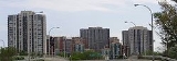
, ranked 3rd best in Canada), numerous restaurants and cafes, and fine boutiques. Residential development consists primarily of single-family dwellings, although several large multi-storey hi rise condominium developments have been built in south Etobicoke near the Humber River over the past few years. Kingsway South
The Kingsway
The Kingsway, known also as Kingsway South, is a residential neighbourhood of Toronto, Ontario, Canada. It is located in the former City of Etobicoke, an area that became the west end of Toronto upon amalgamation in 1998. It is bounded by Bloor Street to the south, Dundas Street to the north, the...
neighbourhood has attracted many affluent individuals and families (as of 2001, over 50% of households have an income in excess of C$
Canadian dollar
The Canadian dollar is the currency of Canada. As of 2007, the Canadian dollar is the 7th most traded currency in the world. It is abbreviated with the dollar sign $, or C$ to distinguish it from other dollar-denominated currencies...
100,000/year), and remains one of Toronto's more prominent neighbourhoods.
The central areas of Etobicoke, although farther from the subway
Toronto subway and RT
The Toronto subway and RT is a rapid transit system in Toronto, Ontario, Canada, consisting of both underground and elevated railway lines, operated by the Toronto Transit Commission . It was Canada's first completed subway system, with the first line being built under Yonge Street, which opened in...
line, are still well-served by public transit buses. These neighbourhoods are generally middle class
Middle class
The middle class is any class of people in the middle of a societal hierarchy. In Weberian socio-economic terms, the middle class is the broad group of people in contemporary society who fall socio-economically between the working class and upper class....
.
Unfortunately, some areas in Etobicoke have become neglected, "inner-ring" suburbs
SubUrbia
subUrbia is a play by Eric Bogosian chronicling the nighttime activities of a group of aimless 20-somethings still living in their suburban Boston hometown and their reunion with a former high school classmate who has become a successful musician...
, such as Rexdale
Rexdale
Rexdale is a neighbourhood located in the north-west corner of Toronto, Ontario, Canada. It covers the northern section of Etobicoke, which was an independent city until it merged with five other municipalities and a regional government to form the new City of Toronto in 1998. Rexdale was named...
. These central and northern areas of Etobicoke contain numerous high-density apartment complexes set in the middle of sizable, open fields and parks.
Etobicoke is home to Humber College
Humber College
Humber College Institute of Technology & Advanced Learning is a polytechnic college in Toronto, Ontario, Canada. Humber offers more than 150 programs including: bachelor’s degree, diploma, certificate, post-graduate certificate and apprenticeship programs, across 40 fields of study. Humber serves...
, University of Guelph-Humber
University of Guelph-Humber
The University of Guelph-Humber is a university-college partnership between the University of Guelph and Humber College. It was established in 2002. It is located on Humber's North Campus in Toronto, Ontario, Canada...
, Woodbine Race Track and Slots
Woodbine Racetrack
Woodbine Racetrack is a Canadian racetrack for Thoroughbred horse races located at 555 Rexdale Blvd. in the city of Toronto, Ontario. It is the only horseracing track in North America which stages, or is capable of staging, thoroughbred and standardbred horseracing programs on the same day...
, Woodbine Centre and Sherway Gardens Shopping Centre
Sherway Gardens
Sherway Garden is a large shopping mall located in Etobicoke with over 200 stores. It is located on the south-east intersection of The Queensway and The West Mall in the west end of the city on the Mississauga border...
.
Education
Public schools in Etobicoke are overseen by the Toronto District School BoardToronto District School Board
Toronto District School Board, also known by the acronym TDSB, is the English-language public school board for Toronto, Ontario, Canada...
. High schools include Central Etobicoke High School, Etobicoke Collegiate Institute
Etobicoke Collegiate Institute
Etobicoke Collegiate Institute is a large high school located at the former centre of Etobicoke in the historic Islington neighbourhood in Toronto's west end, and is overseen by the Toronto District School Board...
, founded in 1928, Kipling Collegiate Institute
Kipling Collegiate Institute
Kipling Collegiate Institute is a public high school in Toronto, Ontario, Canada.Kipling is a member of Peaceful Schools International and has been featured in Maclean's magazine as one of "Canada's Top Ten Extraordinary High Schools", as well as the Toronto Star, as a featured school for its unity...
, Lakeshore Collegiate Institute
Lakeshore Collegiate Institute
Lakeshore Collegiate Institute beginning in 1950, is a high school located in New Toronto that serves the New Toronto, Long Branch, and Mimico working class neighbourhoods in Toronto's west end community of Etobicoke...
(originally New Toronto Secondary School, founded in 1950), Martingrove Collegiate Institute
Martingrove Collegiate Institute
Martingrove Collegiate Institute is a non-semestered public secondary school located on the southeast corner at the intersection of Eglinton Avenue and Martin Grove Road in Toronto, Ontario, Canada. It is overseen by the Toronto District School Board. The school is home to the gifted program in...
, North Albion Collegiate Institute
North Albion Collegiate Institute
North Albion Collegiate Institute is a high school in Etobicoke, Canada. It is part of the Toronto District School Board. The school opened in 1962 to serve the growing suburb known as Rexdale....
, Richview Collegiate Institute
Richview Collegiate Institute
Richview Collegiate Institute is a secondary school in Etobicoke, in the west end of Toronto, Ontario. It is in the Toronto District School Board....
, founded in 1958, Silverthorn Collegiate Institute
Silverthorn Collegiate Institute
Silverthorn Collegiate Institute is a high school located in the west end of Toronto. It is under the sanction of the Toronto District School Board. The name comes from the "The Silverthorn Woods" or "Silverthorn's Bush" that border it on the south and the west...
, Thistletown Collegiate Institute
Thistletown Collegiate Institute
Thistletown Collegiate Institute is a high school in northwest Toronto. Built originally for the Etobicoke Board of Education and now a part of the Toronto District School Board....
, West Humber Collegiate Institute
West Humber Collegiate Institute
West Humber Collegiate Institute is a High school located in Rexdale, at the corner of Martin Grove Road and John Garland Blvd . Schools that feed into WHCI are: Beaumonde Heights Junior Middle School, West Humber Junior Middle School, Elmbank Junior Middle Academy, Greenholme Junior Middle...
, founded in 1966, Etobicoke School of the Arts
Etobicoke School of the Arts
The Etobicoke School of the Arts is a specialized public arts-academic high school located in Etobicoke area of Toronto, Canada. Founded on September 8, 1981, the Etobicoke School of the Arts has the distinction of being the oldest, free standing arts focused high school in Canada...
, founded in 1981 in the former Royal York Collegiate Institute, Scarlett Heights Entrepreneurial Academy
Scarlett Heights Entrepreneurial Academy
Scarlett Heights Entrepreneurial Academy is a secondary school within the Toronto District School Board whose curriculum is broadened through a Student Leadership Development Program. This program extends the base curriculum....
(formerly, Collegiate Institute), and the School of Experiential Education
School of Experiential Education
School of Experiential Education is a small alternative high school located in Toronto's west end. SEE's take on alternative education includes small class sizes , discussion-based courses, thematic English courses, as well as opportunities for independent and project-based learning...
, an alternative school founded in 1971.
In addition to the public school system, Etobicoke is home to several Catholic school
Catholic school
Catholic schools are maintained parochial schools or education ministries of the Catholic Church. the Church operates the world's largest non-governmental school system...
s, overseen by the Toronto Catholic District School Board
Toronto Catholic District School Board
The Toronto Catholic District School Board is the publicly-funded Catholic school board for Toronto, Ontario, Canada, headquartered in North York. It is one of the two English boards of education in the City of Toronto, serving the former municipalities of Scarborough, North York, York, East York,...
. These include Michael Power/St. Joseph
Michael Power/St. Joseph High School
Michael Power/St. Joseph High School is a Toronto Catholic District School Board secondary school in the Etobicoke district of the city of Toronto, Canada....
, Bishop Allen Academy
Bishop Allen Academy
Bishop Allen Academy is a high school located in the The Queensway – Humber Bay neighbourhood of Toronto, Ontario, Canada. It is managed by the Toronto Catholic District School Board.- History :...
, Don Bosco Catholic Secondary School (formerly Keiller Mackay Collegiate Institute), Father John Redmond, Father Henry Carr
Father Henry Carr Secondary School
Father Henry Carr Catholic Secondary School is a Catholic high school administered by the Toronto Catholic District School Board in Etobicoke, Ontario, Canada....
, Holy Child, Our Lady of Sorrows Elementary School, Nativity of Our Lord Elementary School, Father Serra Catholic School, and Monsignor Percy Johnson Catholic Secondary School.
Grade schools include: Second Street Junior-Middle School (1950), Seventh Street Junior School (c1925), and Twentieth Street Junior School (all in New Toronto); James S. Bell Junior-Middle School in Long Branch; John English Junior-Middle School, which is now located in the former Mimico High School (the original John English School is now a community centre), David Hornell Junior School on Victoria Street in Mimico, for grades JK-5 (1961) and the Karen Kain School of the Arts formerly Crestwood Public School.
Other schools include: Humberwood Downs J.M.A., West Humber Junior, Smithfield, Elmbank, Humbercrest, Eatonville Junior School and Missisauga private school; West Glen Junior School, located on Cowley Avenue, educates in grades JK-5 (1953; Norseman Junior Middle School , which opened its doors to students from Kindergarten to Grade 6 in January 1953. From 1968 to 1981, it became the middle school for the area with Grades 6, 7, and 8. Since 1981, the school has served students from Junior Kindergarten to Grade 8. The second storey serves middle school, Grades 6 to 8.
Economy
SkyserviceSkyservice
Skyservice Airlines Inc. was a charter airline based in the Etobicoke area of Toronto, Ontario, Canada. It employed more than 2000 people. Skyservice Airlines Inc. flew within Canada and to the U.S., Caribbean, Mexico, Israel and Europe. During the summer Skyservice sold tickets to Europe from...
, an airline, was headquartered in Etobicoke, until its recent demise. Canada 3000
Canada 3000
Canada 3000 Inc. was a Canadian discount charter airline offering domestic and international flights. It was the largest charter airline in the world at the time of its operation, with over 90 destinations worldwide, although it changed to scheduled service in 2000 after the Canadian Airlines and...
had its headquarters in the City of Etobicoke before it became a part of Toronto; the headquarters remained there until the closing of the airline.
Sport
Etobicoke has a wide range of indoor and outdoor sporting leagues including baseball, soccer, football, hockey, and ringette. Some of the prominent clubs include the Etobicoke KangaroosEtobicoke Kangaroos
The Etobicoke Kangaroos are an amateur Australian Football club based in Etobicoke, Canada. They are members of the Ontario Australian Football League....
Australian rules football
Australian rules football
Australian rules football, officially known as Australian football, also called football, Aussie rules or footy is a sport played between two teams of 22 players on either...
club the Serbian White Eagles FC club, the Stars Diving Club and Toronto Croatia. Southern Etobicoke is also home to the new Lakeshore Lions Arena
Lakeshore Lions Arena
The Lakeshore Lions Arena is a hockey facility run in Toronto's New Toronto neighbourhood in Etobicoke by the Lakeshore Lions Club. It is the former practice facility for the Toronto Maple Leafs NHL hockey team, and the Toronto Marlies AHL "farm" team....
.
Neighbourhoods
Etobicoke is generally divided into three large areas that roughly correspond to the three political ridings. Each consisting of neighbourhoods, mostly developments of 19th century 'postal villagePostal village
A postal village is generally a community, settlement, or hamlet that has a post office and is designated as such by the postal administration. It may be seen as a rural neighbourhood....
s' (rural neighbourhoods), that were built at important points along the early roads and railways; especially the three former 'Lakeshore Municipalities' that separated from Etobicoke in the early 20th century and Etobicoke's central Islington community:
- "The Lakeshore" (Etobicoke—LakeshoreEtobicoke—LakeshoreEtobicoke—Lakeshore is a federal electoral district in Ontario, Canada, that has been represented in the Canadian House of Commons since 1968....
); along the north shore of Lake Ontario and the 'Lake Shore Road' (now Lake Shore Boulevard West), comprises three communities that were the first in Etobicoke to urbanize and became separate municipalities during the first half of the 20th century: the Town of MimicoMimicoThe historic Town of Mimico is a neighbourhood in the south-western part of Toronto, Ontario, Canada. It is located in the south-east corner of the former Township of Etobicoke, and was an independent municipality from 1911 to 1967....
, the Town of New TorontoNew TorontoThe historic Town of New Toronto is a neighbourhood in the south-west end of Toronto, Ontario, Canada. It is located in the south-centre of the former Township of Etobicoke and was an independent municipality from 1913 to 1967, one of the former 'Lakeshore Municipalities'...
, Village of Long BranchLong Branch, TorontoThe former Village of Long Branch is a neighbourhood in the south-west of Toronto, Ontario, Canada. It is located in the south-west corner of the former Township of Etobicoke and was a partially-independent municipality from 1930-1967...
, and related communities that were never separate from the Township of Etobicoke; namely, AlderwoodAlderwood, TorontoAlderwood is a neighbourhood in the city of Toronto, Ontario, Canada. It is in the western section of Toronto, formerly the city of Etobicoke. It is bounded by the Etobicoke Creek to the west, the Gardiner Expressway to the north, the CPR railway to the east and the CNR railway to the...
(originally a suburb of New Toronto), and HumberHumber BayHumber Bay is a bay of Lake Ontario south of Toronto, Ontario, Canada. It is located between Ontario Place on the east and Mimico Creek to the west. The bay gives its name to Etobicoke's Humber Bay neighbourhood.-History:...
Bay (a historic gateway community connecting to Toronto) which was originally sprawl from the east side of the Humber River that was subsequently split by the construction of Ontario's first motor vehicle 'freeway' in 1938, which cuts across the top of southern Etobicoke; (the Queen Elizabeth WayQueen Elizabeth WayThe Queen Elizabeth Way, commonly abbreviated as the QEW, is a 400-Series highway in the Canadian province of Ontario. The freeway links Buffalo, New York and the Niagara Peninsula with Toronto. It begins at the Peace Bridge in Fort Erie and travels around the western shore of Lake Ontario, ending...
). The original remnant residential (northern) section of Humber Bay today is located north of The Queensway, east of Mimico Creek to the Humber River. The commercial, southern section of Humber Bay today retains only Christie's Biscuits bakery, as high-rise condo towers and clustered row housing have forced out virtually all other commercial/industrial employment uses. The former McGuiness Whiskey factory was converted into a high-rise loft condo in the late 1990s which became the centrepiece of the Mystic Pointe development. Etobicoke's first railway opened though the area in the 1855, just north of the Lake Ontario shoreline, leading to the first period of growth as it replaced Dundas Street in Central Etobicoke as the main means of transportation and the industrial centre along its right-of-way.
- Central Etobicoke (Etobicoke Centre); the oldest communities in Etobicoke developed along the first street, Dundas Street, in the south of this area, which crosses the width of Etobicoke on the escarpment formed by the ancient shoreline of Lake Iroquois. This area centres around the Islington community, the former administrative centre of Etobicoke and later Etobicoke's 'downtown' which is near the central 'Six Points' intersection at its western boundary. The rural RichviewRichview, TorontoRichview is a neighbourhood in the city of Toronto, Ontario, Canada. It is located in the former city of Etobicoke. It is bounded on the west by Highway 401 and on the north by the highway and by Dixon Road, Royal York Road on the east, and Eglinton Avenue West along the south...
community developed directly to the north of Islington in the 19th century on Eglinton Ave. (formerly Richview Rd.) as did the gateway Humber HeightsHumber Heights-WestmountHumber Heights-Westmount, also known as Humbervale, is a neighbourhood in Etobicoke, Toronto, Ontario. The neighbourhood is bounded by the west bank of the Humber River, west to Royal York Road and south to Eglinton Avenue West...
communities (connecting to Toronto): Westmount and Humbervale, to the east on Eglinton. Development of the, until then largely undeveloped eastern part of central Etobicoke (originally a forest reserved for the use of government mills as "The King's Mill Reserve"; 'Kingsmill'), the 'Humber Valley', was largely the work of Robert Home Smith starting about 1900 which included the communities of the KingswayThe KingswayThe Kingsway, known also as Kingsway South, is a residential neighbourhood of Toronto, Ontario, Canada. It is located in the former City of Etobicoke, an area that became the west end of Toronto upon amalgamation in 1998. It is bounded by Bloor Street to the south, Dundas Street to the north, the...
and EdenbridgeEdenbridge-Humber ValleyHumber Valley Village is a neighbourhood located in Toronto, Ontario, Canada. It is within the former City of Etobicoke and is a relatively affluent community. The boundaries are from Dundas Street on the south to Islington Avenue to the west, Eglinton Avenue to the north, and the Humber River in...
. As Etobicoke developed in the post war years, low density residential areas filled in most of the rural areas between the old communities including Princess-Rosethorn and Eringate-Centennial-West DeaneEringate-Centennial-West Deane- Location :Eringate-Centennial-West Deane is a neighbourhood located in the north western corner of the city of Toronto, Ontario, Canada, in close proximity to Pearson Airport and Highway 427. It is bounded on the west by Centennial Park and golf course, to the north by Eglinton Avenue West, on...
as well as the older EatonvilleEatonville, OntarioEatonville is a neighbourhood in the Etobicoke community of the city of Toronto, Ontario, Canada. Located west of the area known as Islington, Eatonville is bisected by Highway 427, with the community generally located north of Dundas Street West and south of Rathburn Road...
community to the west of Islington. Central Etobicoke includes Etobicoke's most exclusive neighbourhoods, with fine housing stock and many large treed properties. Along the East and West Mall parallel to Highway 427 exists a mix of hi-rise rentals, townhouses and post war bungalows.
Markland Wood
Markland Wood
Markland Wood is a residential neighbourhood located in Etobicoke, in the City of Toronto, Ontario, Canada. It is bounded by Etobicoke Creek to the west, Elmcrest Creek to the east and surrounded by the Markland Wood Country Club...
is the farthest western community within Etobicoke/Toronto along Bloor Street
Bloor Street
Bloor Street is a major east–west residential and commercial thoroughfare in Toronto, in the Canadian province of Ontario. Bloor Street runs from the Prince Edward Viaduct westward into Mississauga, where it ends at Central Parkway. East of the viaduct, Danforth Avenue continues along the same...
west, a mixed area for housing with some hi-rise rentals.
- Rexdale (Etobicoke NorthEtobicoke NorthEtobicoke North is a federal electoral district in Ontario, Canada, that has been represented in the Canadian House of Commons since 1979. It covers Rexdale, the northern part of Etobicoke, which is part of Toronto....
); named after a 1950s development of the area, the name Rexdale is now more frequently used to refer to all the northern 19th century Etobicoke communities (Clairville, HighfieldWest Humber-ClairvilleClairville is the northwestern most neighbourhood in the city of Toronto, Ontario, Canada. The neighbourhood is part of Rexdale, in north Etobicoke. Today Clairville is almost wholly industrial/commercial.-History:...
, SmithfieldSmithfield, TorontoSmithfield is part of the Rexdale neighbourhood in the northwestern area of Etobicoke, in the City of Toronto, Ontario, Canada. Some new residents to Toronto and new immigrants to Canada are attracted to this neighbourhood, mainly because there is a large amount of affordable public housing...
, ThistletownThistletownThistletown is a culturally diverse neighbourhood in Toronto, Ontario, Canada. Thistletown is also a part of the Rexdale community in the northern part of Etobicoke. It consists of the area surrounding the intersection of Albion Road and Islington Avenue in the former City of Etobicoke...
) which grew along two formerly private roads (now Albion Rd. and Rexdale Blvd.) constructed diagonally across farms in Northern Etobicoke as a shortcut for travellers to Peel County (especially modern Brampton). First developed as an urban area by Rex HeslopRex HeslopRex Wesley Heslop, was a Canadian businessman noted for being a land developer and residential real estate developer.-Early years:Heslop was born on a farm in present day Northern Etobicoke...
in the post war years around the new Rexdale (the Elms) community, northern Etobicoke now has many apartment buildings as well as a large 'skyway' industrial park to the west which developed after Malton Airport (in nearby Mississauga) became Toronto's main 'Pearson International' Airport, and faces many of the problems associated with such areas.
Institutions
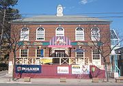
- Etobicoke Civic CentreEtobicoke Civic CentreThe Etobicoke Civic Centre in the Eatonville neighbourhood of Toronto, once housed the municipal government of the former City of Etobicoke. The building was built in 1958 to replace the single storey brick Township of Etobicoke Municipal Hall at 4096 Dundas Street...
Former City Hall. - Etobicoke's former township offices (was also Etobicoke's first Methodist church and is beside Etobicoke's first cemetery)
- Montgomery's InnMontgomery's InnMontgomery's Inn is a historic home and inn in the Islington neighbourhood of Etobicoke in the city of Toronto, Ontario, Canada.Built in 1832 in a Georgian style with later additions, the inn has been restored to an 1847 period, and operates as a museum of the City of Toronto. Once in danger of...
- Mimico GO Station Former Mimico Railway Station was the first station in Etobicoke.
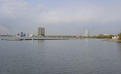
- Humber Bay ParkHumber Bay ParkHumber Bay Park is a waterfront park located in Etobicoke, Ontario, Canada. The park consists of two landspits situated at the mouth of Mimico Creek. The park is on Lake Shore Boulevard West at Park Lawn Road. Humber Bay Park East, connecting to the Humber Bay neighbourhood that existed there...
Artificial Park created with lakefill beginning in the 1970s).
Churches/Temples:
- St. Philip's Anglican Church (1828)
- St. Philip's Lutheran Church (1958)
- Islington Methodist Church (First Methodist Church in Etobicoke, later the Council Offices)
- Christ Church Anglican, Mimico (Burnt down) First Church in Etobicoke.
- St. Leo's Roman Catholic Church, MimicoSt. Leo's Roman Catholic Church, MimicoSt. Leo's Roman Catholic Church on Royal York Rd at Stanley, Mimico in Toronto , Ontario, is the oldest Catholic church in Etobicoke and the only Catholic church in Mimico.-History:First church...
First Catholic Parish in Etobicoke. - St. Michaels Ukrainian Catholic Church (1954)
- St. Demitrius Ukrainian Orthodox Church (1958)
- Swaminarayan Mandir New ornate Hindu Temple in Etobicoke.
- Iglesia ni CristoIglesia ni CristoIglesia ni Cristo also known as INC, is the largest entirely indigenous Christian religious organization that originated from the Philippines and the largest independent church in Asia. Due to a number of similarities, some Protestant writers describe the INC's doctrines as restorationist in...
Schools:
- University of Guelph-HumberUniversity of Guelph-HumberThe University of Guelph-Humber is a university-college partnership between the University of Guelph and Humber College. It was established in 2002. It is located on Humber's North Campus in Toronto, Ontario, Canada...
- Humber CollegeHumber CollegeHumber College Institute of Technology & Advanced Learning is a polytechnic college in Toronto, Ontario, Canada. Humber offers more than 150 programs including: bachelor’s degree, diploma, certificate, post-graduate certificate and apprenticeship programs, across 40 fields of study. Humber serves...
- Lakeshore Collegiate InstituteLakeshore Collegiate InstituteLakeshore Collegiate Institute beginning in 1950, is a high school located in New Toronto that serves the New Toronto, Long Branch, and Mimico working class neighbourhoods in Toronto's west end community of Etobicoke...
Originally New Toronto Secondary School (1950), the first technical Secondary School in Etobicoke - Mimico High School, the first High School in Etobicoke (1924)
- Transfiguration of Our Lord Catholic School
- St.Maurice Catholic School
- Etobicoke Collegiate InstituteEtobicoke Collegiate InstituteEtobicoke Collegiate Institute is a large high school located at the former centre of Etobicoke in the historic Islington neighbourhood in Toronto's west end, and is overseen by the Toronto District School Board...
- Martingrove Collegiate InstituteMartingrove Collegiate InstituteMartingrove Collegiate Institute is a non-semestered public secondary school located on the southeast corner at the intersection of Eglinton Avenue and Martin Grove Road in Toronto, Ontario, Canada. It is overseen by the Toronto District School Board. The school is home to the gifted program in...
- Kipling Collegiate InstituteKipling Collegiate InstituteKipling Collegiate Institute is a public high school in Toronto, Ontario, Canada.Kipling is a member of Peaceful Schools International and has been featured in Maclean's magazine as one of "Canada's Top Ten Extraordinary High Schools", as well as the Toronto Star, as a featured school for its unity...
- Etobicoke School of the ArtsEtobicoke School of the ArtsThe Etobicoke School of the Arts is a specialized public arts-academic high school located in Etobicoke area of Toronto, Canada. Founded on September 8, 1981, the Etobicoke School of the Arts has the distinction of being the oldest, free standing arts focused high school in Canada...
Originally Royal York Collegiate Institute, now the oldest, free-standing arts-focused high school in Canada. - Michael Power/St. Joseph First Catholic Secondary School in Etobicoke.
- Highfield Separate School
- John English Junior Middle School First Primary School in Etobicoke (at its original site). Today's location is the former Mimico High School
- Silverthorn Collegiate InstituteSilverthorn Collegiate InstituteSilverthorn Collegiate Institute is a high school located in the west end of Toronto. It is under the sanction of the Toronto District School Board. The name comes from the "The Silverthorn Woods" or "Silverthorn's Bush" that border it on the south and the west...
- Bishop Allen AcademyBishop Allen AcademyBishop Allen Academy is a high school located in the The Queensway – Humber Bay neighbourhood of Toronto, Ontario, Canada. It is managed by the Toronto Catholic District School Board.- History :...
- St.Benadics Catholic School
- Kingsview Public School
- St.John The Avalgelist Catholic School
- Bishop Allen Secondary school
See also
- List of mayors of Etobicoke
- List of neighbourhoods in Etobicoke