

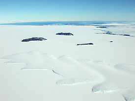
Erebus Ice Tongue
Encyclopedia
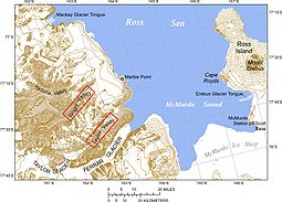
Ross Island
Ross Island is an island formed by four volcanoes in the Ross Sea near the continent of Antarctica, off the coast of Victoria Land in McMurdo Sound.-Geography:...
coastline near Cape Evans
Cape Evans
Cape Evans is a rocky cape on the west side of Ross Island, forming the north side of the entrance to Erebus Bay.The cape was discovered by the Discovery expedition under Robert Falcon Scott, who named it the Skuary. Scott's second expedition, the British Antarctic Expedition , built its...
, Antarctica. The glacier tongue varies in thickness from 50 m at the snout to 300 m at the point where it is grounded on the shoreline. Explorers from Robert F. Scott's
Robert Falcon Scott
Captain Robert Falcon Scott, CVO was a Royal Navy officer and explorer who led two expeditions to the Antarctic regions: the Discovery Expedition, 1901–04, and the ill-fated Terra Nova Expedition, 1910–13...
Discovery Expedition
Discovery Expedition
The British National Antarctic Expedition, 1901–04, generally known as the Discovery Expedition, was the first official British exploration of the Antarctic regions since James Clark Ross's voyage sixty years earlier...
(1901–1904) named and charted the ice tongue.
Erebus Ice Tongue is about 10 m high and is centred upon 77.6 degrees south latitude, 166.75 degrees east longitude. The portion of the ice tongue extending beyond the shoreline or grounding line floats upon the water.
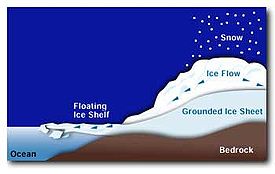
Ice tongues emerge when a glacier
Glacier
A glacier is a large persistent body of ice that forms where the accumulation of snow exceeds its ablation over many years, often centuries. At least 0.1 km² in area and 50 m thick, but often much larger, a glacier slowly deforms and flows due to stresses induced by its weight...
ice stream flows rapidly (relative to surrounding ice) into the sea or a lake, usually in a protected area. For instance, Capes Evans
Cape Evans
Cape Evans is a rocky cape on the west side of Ross Island, forming the north side of the entrance to Erebus Bay.The cape was discovered by the Discovery expedition under Robert Falcon Scott, who named it the Skuary. Scott's second expedition, the British Antarctic Expedition , built its...
and Royds
Cape Royds
Cape Royds, Antarctica, is a dark rock cape forming the west extremity of Ross Island, facing on McMurdo Sound. Discovered by the Discovery Expedition and named for Lieutenant Charles W.R. Royds, Royal Navy, who acted as meteorologist for the expedition...
extending from Ross Island
Ross Island
Ross Island is an island formed by four volcanoes in the Ross Sea near the continent of Antarctica, off the coast of Victoria Land in McMurdo Sound.-Geography:...
protect the Erebus Ice Tongue from the open waters of the Ross Sea
Ross Sea
The Ross Sea is a deep bay of the Southern Ocean in Antarctica between Victoria Land and Marie Byrd Land.-Description:The Ross Sea was discovered by James Ross in 1841. In the west of the Ross Sea is Ross Island with the Mt. Erebus volcano, in the east Roosevelt Island. The southern part is covered...
. Hut Point Peninsula
Hut Point Peninsula
Hut Point Peninsula is a long, narrow land mass from 2 to 3 miles wide and 15 miles long, projecting southwest from the slopes of Mount Erebus on Ross Island....
to the south helps deflect iceberg
Iceberg
An iceberg is a large piece of ice from freshwater that has broken off from a snow-formed glacier or ice shelf and is floating in open water. It may subsequently become frozen into pack ice...
s propelled by prevailing southerly winds.
The long, narrow Erebus ice stream drains from the western slope of Mount Erebus
Mount Erebus
Mount Erebus in Antarctica is the southernmost historically active volcano on Earth, the second highest volcano in Antarctica , and the 6th highest ultra mountain on an island. With a summit elevation of , it is located on Ross Island, which is also home to three inactive volcanoes, notably Mount...
, an active volcano rising 3,794 m (12,448 ft) in elevation. The mountain constantly replenishes the glacial ice stream, as annual snow fall exceeds annual snow melt. The Erebus Ice Tongue is a dynamic structure subject to a host of internal and external stresses which affect its shape, size, and durability.
Ice tongue harbors varied environment
McMurdo Sound
The ice-clogged waters of Antarctica's McMurdo Sound extend about 55 km long and wide. The sound opens into the Ross Sea to the north. The Royal Society Range rises from sea level to 13,205 feet on the western shoreline. The nearby McMurdo Ice Shelf scribes McMurdo Sound's southern boundary...
.
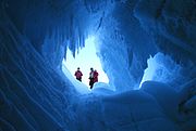
Moreover, such wave action also impacts the ice caves accessed along the leading edges of the ice tongue. The ice caves include inter-locked crevasses covered by snow bridge
Snow bridge
Snow bridge is an arc across a crevasse, a crack in rock, a creek, or some other opening in terrain. It is typically formed by snow drift, which first creates a cornice, which may gradually grow to reach the other side of the opening.-Dangers:...
s. The ice caves are a popular attraction for residents from nearby the McMurdo Station
McMurdo Station
McMurdo Station is a U.S. Antarctic research center located on the southern tip of Ross Island, which is in the New Zealand-claimed Ross Dependency on the shore of McMurdo Sound in Antarctica. It is operated by the United States through the United States Antarctic Program, a branch of the National...
and Scott Base
Scott Base
Scott Base is a research facility located in Antarctica and is operated by New Zealand. It was named after Captain Robert Falcon Scott, Royal Navy, leader of two British expeditions to the Ross Sea area of Antarctica...
research stations. Visitors report observing stalactite-like icicles on the cave ceilings, as well as intricate ice crystals.http://tiger.gsfc.nasa.gov/tiger_11_23.html Sunlight filtering through ice into the caves bathes the interiors with diffuse blue light.http://www.exo.net/~pauld/antarctica/icecave.html
Contemporary cave explorers who squeezed through a narrow tunnel several hundred feet long to emerge into a large cavern describe their Erebus Ice Tongue experience as:
Sitting quietly we absorb the natural beauty. Suddenly, we hear the low grinding noise of the glacier moving and the three of us instinctively look at the narrow opening. Without saying a word we realize that it wouldn’t take much for the entrance to collapse and become sealed and trap us here. One by one we slowly exit. Steve later finds a cave that will safely hold all 10 of us. With childlike enthusiasm we explore the glacial cathedral with walls of deep blue ice. Breaking off pieces of ice, 10 or 20,000 years old, we melt it in our mouths and savour the taste of pure, uncontaminated water.

Weddell seals
Weddell Seal
The Weddell seal , is a relatively large and abundant true seal with a circumpolar distribution surrounding Antarctica. Weddell seals have the most southerly distribution of any mammal, with a habitat that extends as far south as McMurdo Sound...
are commonly sighted by visitors to the Erebus Ice Tongue. Each year 300 to 400 Weddell seal pups are born to a colony of seals that live in adjoining Erebus Bay. The seals have been distinctively marked and re-sighted since 1969.
The nearly 40-year study represents one of the longest field investigations of its type, according to a Montana State University report.
Emperor
Emperor Penguin
The Emperor Penguin is the tallest and heaviest of all living penguin species and is endemic to Antarctica. The male and female are similar in plumage and size, reaching in height and weighing anywhere from . The dorsal side and head are black and sharply delineated from the white belly,...
and Adelie
Adelie Penguin
The Adélie Penguin, Pygoscelis adeliae, is a species of penguin common along the entire Antarctic coast. They are among the most southerly distributed of all seabirds, as are the Emperor Penguin, the South Polar Skua, the Wilson's Storm Petrel, the Snow Petrel, and the Antarctic Petrel...
penguins are also found in the vicinity of the Erebus Ice Tongue. Adelie are particularly noted for their rookeries on Erebus Bay's rocky north shore at nearby Cape Royds
Cape Royds
Cape Royds, Antarctica, is a dark rock cape forming the west extremity of Ross Island, facing on McMurdo Sound. Discovered by the Discovery Expedition and named for Lieutenant Charles W.R. Royds, Royal Navy, who acted as meteorologist for the expedition...
. Penguins, like the Weddell seal, are preyed upon by Orcas and Lepoard seals. The presence of penguins also attracts the predatory Skua
Skua
The skuas are a group of seabirds with about seven species forming the family Stercorariidae and the genus Stercorarius. The three smaller skuas are called jaegers in North America....
seabird.
Scarce mention of the ice tongue's surface, which is more than a mile wide, is made in popular literature. A notable exception is in Ernest Shackleton's book, South! The leader of a December 1916 search party seeking fellow explorers missing in vicinity of the ice tongue made the following report to Shackleton:
On January 2 thick weather caused party to lay up. On 3rd, glacier was further examined, and several slopes formed by snow led to top of glacier, but crevasses between slope and the tongue prevented crossing. The party then proceeded round the Tongue to Tent Island, which was also searched, a complete tour of the island being made.
Ice tongue dynamics
Ice sheet dynamics
Ice sheet dynamics describe the motion within large bodies of ice, such those currently on Greenland and Antarctica. Ice motion is dominated by the movement of glaciers, whose gravity-driven activity is controlled by two main variable factors: the temperature and strength of their bases...
within floating ice streams such as the Erebus Ice Tongue are complex. For instance, typically ice streams such as the Erebus Ice Tongue, which ranges from 50 to 300 meters thick, contain smaller streams of ice. Each ice flow produces its own set of stress fields. Thus, throughout the ice tongue, different flow rates and tensions are present.
Stress and friction increase along the flanks of ice streams such as the Erebus Ice Tongue. Stress appears as crevasses as the ice flow rate is slowed. Friction created by the Earth's topography at the bottom of the glacier also slows the ice stream. However, just the opposite occurs with basal sliding
Basal sliding
Basal sliding is the act of a glacier sliding over the bed before it due to meltwater under the ice acting as a lubricant. This movement very much depends on the temperature of the area, the slope of the glacier, the bed's sediment size, the amount of meltwater from the glacier, and the glacier's...
. Such sliding features the glacier jerking forward due to lubrication from bottom meltwater.
Ice streams such as the Erebus Ice Tongue wax and wane like the moon. Indeed, British researchers in 2006 discovered a correlation between lunar tides (caused by gravitational pull) and variances in flow speed of the Rutland Ice Stream in Antarctica. Previously a team of U.S. NASA, Penn State, and University of Newcastle; Newcastle Upon Tyne, England; made similar observations of Whillan's Ice Stream in Antarctica.
However, more established research unrelated to lunar forces is available regarding cyclical glacier growth and decay. Such research reveals that glacier growth can produce slow-motion surges in the glacier's movement. Such surges may occur over a period of months or years. Then the movement stops. Scientists have measured Erebus Ice Tongue's length as growing about 160 meters yearly.
The Erebus Ice Tongue flow pushes the glacier into Erebus Bay
Erebus Bay
Erebus Bay is a bay about 13 nautical miles wide between Cape Evans and Hut Point Peninsula, on the west side of Ross Island. The bay was explored by the Discovery expedition under Scott. It was named by Scott's second expedition, the British Antarctic Expedition , which built its headquarters...
where it butts against seasonal ice pack. This massive but gradual collision of ice against ice creates pressure ridges in the glacier. Portions of the ice tongue become unstable, rupture, and calve icebergs. Such instability in part comes from the flexing and tension the ice beam undergoes from being cantilevered over the sea. Moreover, the river of ice carries with it weaknesses introduced by earlier fractures experienced during its journey down the slopes of Mount Erebus
Mount Erebus
Mount Erebus in Antarctica is the southernmost historically active volcano on Earth, the second highest volcano in Antarctica , and the 6th highest ultra mountain on an island. With a summit elevation of , it is located on Ross Island, which is also home to three inactive volcanoes, notably Mount...
.
Iceberg calving
The forces of wave action from McMurdo SoundMcMurdo Sound
The ice-clogged waters of Antarctica's McMurdo Sound extend about 55 km long and wide. The sound opens into the Ross Sea to the north. The Royal Society Range rises from sea level to 13,205 feet on the western shoreline. The nearby McMurdo Ice Shelf scribes McMurdo Sound's southern boundary...
, tides, and internal stresses exploit the ice tongue's weaknesses. Subsequently small iceberg
Iceberg
An iceberg is a large piece of ice from freshwater that has broken off from a snow-formed glacier or ice shelf and is floating in open water. It may subsequently become frozen into pack ice...
s and bergy bits typically calf from the Erebus Ice Tongue but only when the sea ice has broken up. Subsequently, iceberg calving
Ice calving
Ice calving, also known as glacier calving or iceberg calving, is a form of ice ablation or ice disruption. It is the sudden release and breaking away of a mass of ice from a glacier, iceberg, ice front, ice shelf, or crevasse...
is seasonal and periodic, as open water is needed to release the bergs into Erebus Bay.
Waters at the ice tongue that receive the icebergs vary in depth from a minimum of 155 m to 475 m. Members of Robert F. Scott's
Robert Falcon Scott
Captain Robert Falcon Scott, CVO was a Royal Navy officer and explorer who led two expeditions to the Antarctic regions: the Discovery Expedition, 1901–04, and the ill-fated Terra Nova Expedition, 1910–13...
Terra Nova Expedition
Terra Nova Expedition
The Terra Nova Expedition , officially the British Antarctic Expedition 1910, was led by Robert Falcon Scott with the objective of being the first to reach the geographical South Pole. Scott and four companions attained the pole on 17 January 1912, to find that a Norwegian team led by Roald...
first observed the glacier tongue calving in March 1911 when a 4 km section broke off during a gale. A similar event in March 1990 produced a 100-million ton iceberg, 3.5 km long, from the glacier tongue. In addition, observers note that the glacier tongue experienced a major calving event in the early 1940s. Such calving along the glacier snout naturally leads to shortening, while icebergs released from the ice tongue sides contribute to the glacier's narrowing. The Erebus Ice Tongue produces flat-topped or tabular icebergs.
See also
- GlacierGlacierA glacier is a large persistent body of ice that forms where the accumulation of snow exceeds its ablation over many years, often centuries. At least 0.1 km² in area and 50 m thick, but often much larger, a glacier slowly deforms and flows due to stresses induced by its weight...
- McMurdo SoundMcMurdo SoundThe ice-clogged waters of Antarctica's McMurdo Sound extend about 55 km long and wide. The sound opens into the Ross Sea to the north. The Royal Society Range rises from sea level to 13,205 feet on the western shoreline. The nearby McMurdo Ice Shelf scribes McMurdo Sound's southern boundary...
- Mount ErebusMount ErebusMount Erebus in Antarctica is the southernmost historically active volcano on Earth, the second highest volcano in Antarctica , and the 6th highest ultra mountain on an island. With a summit elevation of , it is located on Ross Island, which is also home to three inactive volcanoes, notably Mount...
- Ross IslandRoss IslandRoss Island is an island formed by four volcanoes in the Ross Sea near the continent of Antarctica, off the coast of Victoria Land in McMurdo Sound.-Geography:...
- List of glaciers in the Antarctic