

Emmaus
Encyclopedia
New Testament
The New Testament is the second major division of the Christian biblical canon, the first such division being the much longer Old Testament....
reports that Jesus
Jesus
Jesus of Nazareth , commonly referred to as Jesus Christ or simply as Jesus or Christ, is the central figure of Christianity...
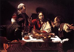
appeared before two of his followers in Emmaus after his resurrection
Resurrection of Jesus
The Christian belief in the resurrection of Jesus states that Jesus returned to bodily life on the third day following his death by crucifixion. It is a key element of Christian faith and theology and part of the Nicene Creed: "On the third day he rose again in fulfillment of the Scriptures"...
.
Emmaus in the New Testament
The author of the Gospel of LukeGospel of Luke
The Gospel According to Luke , commonly shortened to the Gospel of Luke or simply Luke, is the third and longest of the four canonical Gospels. This synoptic gospel is an account of the life and ministry of Jesus of Nazareth. It details his story from the events of his birth to his Ascension.The...
, at , writes that Jesus
Jesus
Jesus of Nazareth , commonly referred to as Jesus Christ or simply as Jesus or Christ, is the central figure of Christianity...
appeared to two disciples who were walking from Jerusalem to Emmaus, which is described as being 60 stadia from Jerusalem (10.4 to 12 km depending on what definition of stadia is used), after his resurrection. One of the disciples is named as Cleopas
Cleopas
Cleopas was a figure of early Christianity, one of the two disciples who encountered Jesus during the Road to Emmaus appearance in the Gospel of ....
in verse 18, while his companion remains unnamed.
The author of Luke
Gospel of Luke
The Gospel According to Luke , commonly shortened to the Gospel of Luke or simply Luke, is the third and longest of the four canonical Gospels. This synoptic gospel is an account of the life and ministry of Jesus of Nazareth. It details his story from the events of his birth to his Ascension.The...
places the story on the evening of the day of Jesus' resurrection. The two disciples have heard the tomb of Jesus was found empty earlier that day. They are discussing the events of the past few days when a stranger asks them what they are discussing. "Their eyes were kept from recognizing him." He soon rebukes them for their unbelief and gives them a Bible study on prophecies about the Messiah. On reaching Emmaus, they ask the stranger to join them for the evening meal. When he breaks the bread "their eyes were opened" and they recognize him as the resurrected Jesus. Jesus immediately vanishes. Cleopas and his friend then hasten back to Jerusalem to carry the news to the other disciples, and arrive in time to proclaim to the eleven who were gathered together with others that Jesus truly is alive. While describing the events, Jesus appeared again to all who were there, giving them a commission to evangelize. Then he took them out as far as Bethany and blessed them before ascending back into heaven.
A similar event is mentioned in the longer ending of Mark
Mark 16
Mark 16 is the final chapter of the Gospel of Mark in the New Testament of the Christian Bible. It begins with the discovery of the empty tomb by Mary Magdalene, Mary the mother of James, and Salome — there they encounter a man dressed in white who announces the Resurrection of Jesus.Verse 8 ends...
, but this is believed to be a late addition derived from the gospel of Luke and the incident is not mentioned in the gospels of Matthew
Gospel of Matthew
The Gospel According to Matthew is one of the four canonical gospels, one of the three synoptic gospels, and the first book of the New Testament. It tells of the life, ministry, death, and resurrection of Jesus of Nazareth...
and John
Gospel of John
The Gospel According to John , commonly referred to as the Gospel of John or simply John, and often referred to in New Testament scholarship as the Fourth Gospel, is an account of the public ministry of Jesus...
.
Historical identification
Many sites have been suggested for the biblical Emmaus, among them Emmaus NicopolisEmmaus Nicopolis
Emmaus Nicopolis was the Roman name for a city associated with the Emmaus of the New Testament, where Jesus is said to have appeared after his death and resurrection. In the modern age, the site was the location of the Palestinian Arab village of Imwas, near the Latrun junction, between Jerusalem...
(ca. 160 stadia from Jerusalem), Kiryat Anavim (66 stadia from Jerusalem on the carriage road to Jaffa
Jaffa
Jaffa is an ancient port city believed to be one of the oldest in the world. Jaffa was incorporated with Tel Aviv creating the city of Tel Aviv-Yafo, Israel. Jaffa is famous for its association with the biblical story of the prophet Jonah.-Etymology:...
), Coloniya (36 stadia on the carriage road to Jaffa), el-Kubeibeh (63 stadia, on the Roman
Ancient Rome
Ancient Rome was a thriving civilization that grew on the Italian Peninsula as early as the 8th century BC. Located along the Mediterranean Sea and centered on the city of Rome, it expanded to one of the largest empires in the ancient world....
road to Lydda
Lod
Lod is a city located on the Sharon Plain southeast of Tel Aviv in the Center District of Israel. At the end of 2010, it had a population of 70,000, roughly 75 percent Jewish and 25 percent Arab.The name is derived from the Biblical city of Lod...
), Artas
Artas, Bethlehem
Artas is a Palestinian village located four kilometers southwest of Bethlehem in the Bethlehem Governorate in the central West Bank. According to the Palestinian Central Bureau of Statistics, the town had a population of 3,663 in 2007.-History:...
(60 stadia from Jerusalem) and Khurbet al-Khamasa (86 stadia on the Roman road to Eleutheropolis
Eleutheropolis
Eleutheropolis was the Greek name of a Roman city in Israel, some 53 km southwest of Jerusalem. Its remains still straddle the ancient road to Gaza. The site— already rendered as Baitogabra in Ptolemy's Geography— was called Beit Guvrin and Bet Gubrin in the Talmud...
). The oldest identification that is currently known is Emmaus Nicopolis.
Emmaus-Nicopolis/Imwas
The first modern site identification of Emmaus was by the explorer Edward RobinsonEdward Robinson (scholar)
Edward Robinson was an American biblical scholar, known as the “Father of Biblical Geography.” He has been referred to as the “founder of modern Palestinology.” -Biography:...
, who equated it with the Palestinian Arab village of Imwas
Imwas
Imwas was a Palestinian Arab village located southeast of the city of Ramla and from Jerusalem in the Latrun salient of the West Bank. Often identified with the biblical Emmaus, over the course of two millennia, Imwas was intermittently inhabited and was ruled by the Romans , Arab caliphates,...
. Before its destruction in 1967, the village of Imwas was located at the end of the Ayalon Valley, on the border of the hill country of Judah
West Bank
The West Bank ) of the Jordan River is the landlocked geographical eastern part of the Palestinian territories located in Western Asia. To the west, north, and south, the West Bank shares borders with the state of Israel. To the east, across the Jordan River, lies the Hashemite Kingdom of Jordan...
, at 153 stadia (18.6 miles) from Jerusalem via the Kiryat Yearim Ridge Route, 161 stadia (19.6 miles) via the Beth-Horon Ridge Route
Beth-horon
Bethoron was the name for two adjacent towns, Bethoron Elyon , and Bethoron Tahton , named for the Egypto-Canaanite deity Horon mentioned in Ugaritic literature and other texts...
and 1600 feet (487.7 m) lower by elevation.
Eusebius was probably the first to mention Nicopolis as biblical Emmaus in his Onomasticon. Jerome
Jerome
Saint Jerome was a Roman Christian priest, confessor, theologian and historian, and who became a Doctor of the Church. He was the son of Eusebius, of the city of Stridon, which was on the border of Dalmatia and Pannonia...
, who translated Eusebius’ book, implied in his letter 108 that there was a church in Nicopolis built in the house of Cleopas
Cleopas
Cleopas was a figure of early Christianity, one of the two disciples who encountered Jesus during the Road to Emmaus appearance in the Gospel of ....
where Jesus broke bread on that late journey. From the 4th century on, the site was commonly identified as the biblical Emmaus.
Archaeologically, many remains have been excavated at the site of the former Palestinian village, now located inside Canada Park
Canada Park
Canada Park is a national park stretching over 7,000 dunams, mostly in the West Bank, with a portion in the region that was a no man's land before 1967 and incorporated into Israel in 1967. It is maintained by the Jewish National Fund of Canada...
, which support historical and traditional claims. Five structures were found and dated, including a Christian basilica from the 3rd century, another basilica from the 6th century and a 12th century Crusader church. Emmaus Nicopolis
Emmaus Nicopolis
Emmaus Nicopolis was the Roman name for a city associated with the Emmaus of the New Testament, where Jesus is said to have appeared after his death and resurrection. In the modern age, the site was the location of the Palestinian Arab village of Imwas, near the Latrun junction, between Jerusalem...
is a titular see
Titular see
A titular see in various churches is an episcopal see of a former diocese that no longer functions, sometimes called a "dead diocese". The ordinary or hierarch of such a see may be styled a "titular bishop", "titular metropolitan", or "titular archbishop"....
of the Roman Catholic Church
Roman Catholic Church
The Catholic Church, also known as the Roman Catholic Church, is the world's largest Christian church, with over a billion members. Led by the Pope, it defines its mission as spreading the gospel of Jesus Christ, administering the sacraments and exercising charity...
.
Al-Qubeibeh/Castellum Emmaus/Chubebe/Qubaibat
Another possibility is the village of al-Qubeibeh, west of Nebi Samwil on the Beit Horon road northwest of Jerusalem. The town, meaning “little domes” in Arabic, is located at about 65 stadia from Jerusalem. A Roman fort subsequently named Castellum Emmaus (from the Latin root castra, meaning encampment) was discovered at the site in 1099 by the Crusaders.In the 12th century, the Crusaders of the Kingdom of Jerusalem
Kingdom of Jerusalem
The Kingdom of Jerusalem was a Catholic kingdom established in the Levant in 1099 after the First Crusade. The kingdom lasted nearly two hundred years, from 1099 until 1291 when the last remaining possession, Acre, was destroyed by the Mamluks, but its history is divided into two distinct periods....
called the site "Small Mahomeria," in order to distinguish it from “Large Mahomeria” near Ramallah
Ramallah
Ramallah is a Palestinian city in the central West Bank located 10 kilometers north of Jerusalem, adjacent to al-Bireh. It currently serves as the de facto administrative capital of the Palestinian National Authority...
. Sounding similar to “Mahommed,” the term was used in medieval times to describe a place inhabited or used for prayer by Muslims. It was referred to as Qubaibat for the first time at the end of that same century by the writer Abu Shama, who writes in his Book of Two Gardens about a Muslim prince falling into the hands of the Crusaders at this spot. The Franciscans built a church here in 1902, on the ruins of a Crusader basilica. Excavations in 1943 revealed artifacts from the Hellenistic, Roman and Byzantine periods.
Abu-Ghosh/Kiryat Anavim
Abu GhoshAbu Ghosh
Abu Ghosh is an Israeli Arab town in Israel, located west of Jerusalem on the Tel Aviv-Jerusalem highway. It is situated 610–720 meters above sea level. In 2010, it set the Guinness World Record for largest dish of hummus...
is located in the middle of the Kiryat Yearim Ridge Route between Nicopolis and Jerusalem, nine miles (83 stadia) from the capital. A convent of Minorites with a Gothic church in Abu Ghosh was turned into a stable. Robinson dated it to the Crusader period and declared it "more perfectly preserved than any other ancient church in Palestine." Excavations carried out in 1944 corresponded with Crusader identification of the site as Emmaus.
Emmaus/Colonia/Motza/Ammassa/Ammaous/Beit Mizzeh
Colonia, between Abu Ghosh and Jerusalem on the Kiryat Yearim Ridge Route is another possibility. At a distance of 35 stadia (four miles) from Jerusalem, it was referred to as MotzaMotza
Motza ת is a neighbourhood in the western edge of Jerusalem, Israel, located 600 metres above sea level. In the Judean Hills, surrounded by forest, it is a relatively isolated place connected to Jerusalem by the Jerusalem-Tel Aviv highway and the winding mountain road to Har Nof...
in the Old Testament, the Talmud and the writings of Josephus Flavius.
One mile to the north is a ruin called Beit Mizzeh, identified as the biblical Motza. Listed among the Benjamite cities of Joshua 18:26, it was referred to in the Talmud as a place where people would come to cut young willow-branches as a part of the celebration of Sukkot
Sukkot
Sukkot is a Biblical holiday celebrated on the 15th day of the month of Tishrei . It is one of the three biblically mandated festivals Shalosh regalim on which Hebrews were commanded to make a pilgrimage to the Temple in Jerusalem.The holiday lasts seven days...
(Mishnah
Mishnah
The Mishnah or Mishna is the first major written redaction of the Jewish oral traditions called the "Oral Torah". It is also the first major work of Rabbinic Judaism. It was redacted c...
, Sukkah
Sukkah
A sukkah is a temporary hut constructed for use during the week-long Jewish festival of Sukkot. It is topped with branches and often well decorated with autumnal, harvest or Judaic themes...
4.5: 178). According to Josephus, Amassa (ancient Latin manuscripts) or Ammaous (medieval Greek manuscripts) was about 3.5 Roman miles (30 stadia) or 7 miles (60 stadia)
from Jerusalem. A group of 800 soldiers settled here after the First Jewish Revolt. It is believed that the Latin Amassa and the Greek Ammaous are derived from the Hebrew name Motza. Motza was identified as the biblical Emmaus by Birch, and later Savi.
Symbolic identification
One of the oldest extant versions of the Gospel of Luke, preserved in the Codex BezaeCodex Bezae
The Codex Bezae Cantabrigensis, designated by siglum Dea or 05 , δ 5 , is a codex of the New Testament dating from the 5th century written in an uncial hand on vellum. It contains, in both Greek and Latin, most of the four Gospels and Acts, with a small fragment of the 3 John...
, reads "Oulammaus" instead of Emmaus. In Septuagint, the Greek
Greek language
Greek is an independent branch of the Indo-European family of languages. Native to the southern Balkans, it has the longest documented history of any Indo-European language, spanning 34 centuries of written records. Its writing system has been the Greek alphabet for the majority of its history;...
translation of the Old Testament
Old Testament
The Old Testament, of which Christians hold different views, is a Christian term for the religious writings of ancient Israel held sacred and inspired by Christians which overlaps with the 24-book canon of the Masoretic Text of Judaism...
scriptures, Oulammaus was the place where Jacob
Jacob
Jacob "heel" or "leg-puller"), also later known as Israel , as described in the Hebrew Bible, the Talmud, the New Testament and the Qur'an was the third patriarch of the Hebrew people with whom God made a covenant, and ancestor of the tribes of Israel, which were named after his descendants.In the...
was visited by God in his dream, while sleeping on a rock. However, Oulammaus was not a real place name at all, but created only by an unfortunate translation mistake. The original name in Hebrew was "Luz". This mistake has long been corrected, but it was still there at the time when the Gospel was written around 100 AD. Thus, a theory has been put forward, that the story in the Gospel was merely symbolic, wanting to draw a parallel between Jacob being visited by God and the disciples being visited by Jesus. This symbolic significance, however, would not preclude the account being historically accurate. To be noted also is that Jacob was sleeping on a rock and Jesus' main disciple Simon Peter was called by the name of rock (Petros).