
Elstree South tube station
Encyclopedia
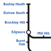
Elstree South tube station (usually just Elstree on Underground maps
) was an unbuilt London Underground
station in Elstree
, Hertfordshire
. It was designed by Charles Holden
. The planned location of the station was adjacent to the A5183 north of the junction with the A41 and to where junction 4 of the M1 motorway
was subsequently built.
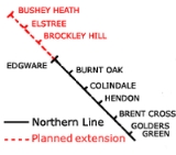
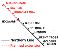 The station was the second of three planned by London Underground in 1935 for an extension of the Northern Line
from Edgware
to Bushey Heath.
The extension was part of the Northern Heights project which was intended to electrify a number of steam-operated London and North Eastern Railway
(LNER) branch lines and to incorporate them into the Northern Line. The powers to build the extension came from the purchase in 1922 of the unbuilt Watford and Edgware Railway
which had planned an extension of the Edgware, Highgate and London Railway
to Watford Junction via Bushey, but had never been able to raise the capital required for construction to start.
 Construction works on the Northern Heights project began in the late 1930s but were interrupted by the outbreak of the Second World War. Most of the work undertaken to that date had been carried out on the existing LNER branch tracks but some work between Edgware and Elstree had taken place. Land had been purchased along the route of the new rail line and some earthworks had been constructed. North of Brockley Hill station a pair of 500m tunnels were partly constructed through a hill towards Elstree . The northern tunnel mouths would have opened immediately before the station. Also adjacent to the site the carriage depot for the line was completed in 1939 but during the war it was converted to use as a munitions factory. After the war it became Aldenham Bus Overhaul Works
until it was closed in the 1980s and demolished in the 1990s.
The sites of all three new stations were in semi-rural locations and, as it had elsewhere, it was intended that the opening of the new section of Underground line would stimulate the construction of new residential estates that the stations would then serve. After the war, new legislation was introduced with the intention of limiting the continuing expansion of urban areas into their surrounding countryside. This legistation created the Metropolitan Green Belt
around London and the area designated included the area covered by the new Northern Line extension. Without the possibility of constructing the new housing estates, the new line had no purpose and the plans for the extension were cancelled in 1950.
Through disuse the Elstree tunnels became flooded and dangerous. The entrances were filled in and buried in the 1970s and today nothing is visible on the surface. The extensive cutting created for the motorway junction and slip roads crosses the tunnel alignment. Some traces of earthworks including foundations of a viaduct still survive at the site of Brockley Hill station . The route of the line between Edgware and Brockley Hill is now occupied by housing and roads including Sterling Avenue and Shelley Close.
Tube map
The Tube map is a schematic transit map representing the lines and stations of London's rapid transit railway systems, namely the London Underground , the Docklands Light Railway and London Overground....
) was an unbuilt London Underground
London Underground
The London Underground is a rapid transit system serving a large part of Greater London and some parts of Buckinghamshire, Hertfordshire and Essex in England...
station in Elstree
Elstree
Elstree is a village in the Hertsmere borough of Hertfordshire on the A5 road, about 10 miles north of London. In 2001, its population was 4,765, and forms part of the civil parish of Elstree and Borehamwood, originally known simply as Elstree....
, Hertfordshire
Hertfordshire
Hertfordshire is a ceremonial and non-metropolitan county in the East region of England. The county town is Hertford.The county is one of the Home Counties and lies inland, bordered by Greater London , Buckinghamshire , Bedfordshire , Cambridgeshire and...
. It was designed by Charles Holden
Charles Holden
Charles Henry Holden, Litt. D., FRIBA, MRTPI, RDI was a Bolton-born English architect best known for designing many London Underground stations during the 1920s and 1930s, for Bristol Central Library, the Underground Electric Railways Company of London's headquarters at 55 Broadway and for the...
. The planned location of the station was adjacent to the A5183 north of the junction with the A41 and to where junction 4 of the M1 motorway
M1 motorway
The M1 is a north–south motorway in England primarily connecting London to Leeds, where it joins the A1 near Aberford. While the M1 is considered to be the first inter-urban motorway to be completed in the United Kingdom, the first road to be built to motorway standard in the country was the...
was subsequently built.
History
Northern Line
The Northern line is a London Underground line. It is coloured black on the Tube map.For most of its length it is a deep-level tube line. The line carries 206,734,000 passengers per year. This is the highest number of any line on the London Underground system, but the Northern line is unique in...
from Edgware
Edgware
Edgware is an area in London, situated north-northwest of Charing Cross. It forms part of both the London Borough of Barnet and the London Borough of Harrow. The area is identified in the London Plan as one of 35 major centres in Greater London....
to Bushey Heath.
The extension was part of the Northern Heights project which was intended to electrify a number of steam-operated London and North Eastern Railway
London and North Eastern Railway
The London and North Eastern Railway was the second-largest of the "Big Four" railway companies created by the Railways Act 1921 in Britain...
(LNER) branch lines and to incorporate them into the Northern Line. The powers to build the extension came from the purchase in 1922 of the unbuilt Watford and Edgware Railway
Watford and Edgware Railway
The Watford and Edgware Railway was a railway company established in the 1860s that intended to build a railway that would run between Edgware and Watford, via Bushey...
which had planned an extension of the Edgware, Highgate and London Railway
Edgware, Highgate and London Railway
The Edgware, Highgate and London Railway was a railway in north London. The railway was a precursor of parts of London Underground's Northern Line and was, in the 1930s the core of an ambitious expansion plan for that line which was thwarted by the Second World War...
to Watford Junction via Bushey, but had never been able to raise the capital required for construction to start.
Aldenham Works
The Aldenham Works, or Aldenham Bus Overhaul Works, was the main London Transport Bus overhaul works. It was located on the edge of the Hertfordshire village of Elstree and not Aldenham despite being officially called Aldenham Works. In its heyday, 50 buses a week were overhauled there, and it was...
until it was closed in the 1980s and demolished in the 1990s.
The sites of all three new stations were in semi-rural locations and, as it had elsewhere, it was intended that the opening of the new section of Underground line would stimulate the construction of new residential estates that the stations would then serve. After the war, new legislation was introduced with the intention of limiting the continuing expansion of urban areas into their surrounding countryside. This legistation created the Metropolitan Green Belt
Metropolitan Green Belt
The Metropolitan Green Belt is a statutory green belt around London, England. It includes designated parts of Greater London and the surrounding counties of Bedfordshire, Berkshire, Buckinghamshire, Essex, Hertfordshire, Kent and Surrey in the South East and East of England regions.-History:The...
around London and the area designated included the area covered by the new Northern Line extension. Without the possibility of constructing the new housing estates, the new line had no purpose and the plans for the extension were cancelled in 1950.
Through disuse the Elstree tunnels became flooded and dangerous. The entrances were filled in and buried in the 1970s and today nothing is visible on the surface. The extensive cutting created for the motorway junction and slip roads crosses the tunnel alignment. Some traces of earthworks including foundations of a viaduct still survive at the site of Brockley Hill station . The route of the line between Edgware and Brockley Hill is now occupied by housing and roads including Sterling Avenue and Shelley Close.
See also
- Edgware, Highgate and London RailwayEdgware, Highgate and London RailwayThe Edgware, Highgate and London Railway was a railway in north London. The railway was a precursor of parts of London Underground's Northern Line and was, in the 1930s the core of an ambitious expansion plan for that line which was thwarted by the Second World War...
- LNER branch line taken over by London Underground as part of the Northern Heights project