

Ellwood Oil Field
Encyclopedia
Oil field
An oil field is a region with an abundance of oil wells extracting petroleum from below ground. Because the oil reservoirs typically extend over a large area, possibly several hundred kilometres across, full exploitation entails multiple wells scattered across the area...
s adjoining the city of Goleta, California
Goleta, California
Goleta is a city in southern Santa Barbara County, California, USA. It was incorporated as a city in 2002, after a long period as the largest unincorporated, populated area in the county. As of the 2000 census, the Census-designated place had a total population of 55,204, however, a significant...
, about twelve miles (19 km) west of Santa Barbara
Santa Barbara, California
Santa Barbara is the county seat of Santa Barbara County, California, United States. Situated on an east-west trending section of coastline, the longest such section on the West Coast of the United States, the city lies between the steeply-rising Santa Ynez Mountains and the Pacific Ocean...
, largely in the Santa Barbara Channel
Santa Barbara Channel
The Santa Barbara Channel is a portion of the Pacific Ocean which separates the mainland of California from the northern Channel Islands. It is generally south of the city of Santa Barbara, and west of the city of Ventura....
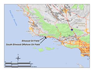
. A richly productive field in the 1930s, the Ellwood Oil Field was important to the economic development of the Santa Barbara area. A Japanese submarine shelled it during World War II, the first direct attack on the U.S. mainland since the War of 1812, causing an invasion scare on the West Coast.
Setting
Rancho Dos Pueblos
Rancho Dos Pueblos was a Mexican land grant in present day Santa Barbara County, California given in 1842 by Governor Juan Alvarado to Nicolas A. Den. The land extended along the Pacific coast to the northwest of the pueblo and Presidio of Santa Barbara, from Goleta Slough west to Dos Pueblos...
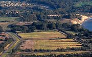
. The onshore portions of the field include beach, coastal bluffs, blufftop grasslands, and eucalyptus
Eucalyptus
Eucalyptus is a diverse genus of flowering trees in the myrtle family, Myrtaceae. Members of the genus dominate the tree flora of Australia...
groves. Some of the former oil field is now part of the Ellwood-Devereux Open Space, maintained by the city of Goleta, and the Bacara Resort, Sandpiper Golf Course, and new Goleta housing developments sit on areas formerly occupied by pump-jacks, derricks, and oil storage tanks.
The climate is Mediterranean
Mediterranean climate
A Mediterranean climate is the climate typical of most of the lands in the Mediterranean Basin, and is a particular variety of subtropical climate...
, with an equable temperature regime year-round, and most of the precipitation falling between October and April in the form of rain. Freezes are rare. Runoff is towards the ocean, and to a few vernal pool
Vernal pool
Vernal pools, also called vernal ponds or ephemeral pools, are temporary pools of water. They are usually devoid of fish, and thus allow the safe development of natal amphibian and insect species...
s on the bluffs. The offshore portions of the Ellwood oil field are in relatively shallow water, and were drilled from piers.
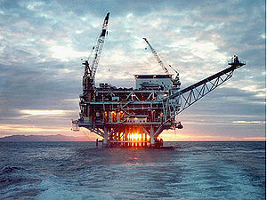
The South Ellwood Offshore field is entirely under the Pacific Ocean, about two miles (3 km) from the main onshore oil field. It is entirely within the State Tidelands zone, which encompasses areas within three nautical miles (6 km) of shore. These regions are subject to state rather than exclusively Federal regulation. Currently the only production from this field is from Platform Holly, which is in 211 feet (64.3 m) of water, about two miles (3 km) from the coast at Coal Oil Point. Numerous directionally-drilled oil wells originate at the platform, and several pipelines connect the platform to an onshore oil processing facility adjacent to the Sandpiper Golf Course.
Geology
The Ellwood Oil Field is roughly five miles long and up to a mile wide, with both its eastern and western extremity onshore. It is an anticlinalAnticline
In structural geology, an anticline is a fold that is convex up and has its oldest beds at its core. The term is not to be confused with antiform, which is a purely descriptive term for any fold that is convex up. Therefore if age relationships In structural geology, an anticline is a fold that is...
structure, with oil trapped stratigraphically by the anticline. The More Ranch Fault provides an impermeable barrier on the northeast. Oil occurs in several pools, with the largest being in the Vaqueros Sandstone, approximately 3400 feet (1,036.3 m) below ground surface. Other significant pools occur in the Rincon Formation
Rincon Formation
The Rincon Formation is a sedimentary geologic unit of Lower Miocene age, abundant in the coastal portions of southern Santa Barbara County, California eastward into Ventura County...
at a depth of 2600 feet (792.5 m), and in the Upper Sespe Formation
Sespe Formation
The Sespe Formation is a widespread fossiliferous sedimentary geologic unit in southern and south central California in the United States. It is of nonmarine origin, consisting predominantly of sandstones and conglomerates laid down in a riverine, shoreline, and floodplain environment between the...
at 3700 feet (1,127.8 m) below ground surface.
The Ellwood Oil Field contained approximately 106 Moilbbl of oil, almost all of which has been removed, to the degree possible with the technology available until the early 1970s. The field now has been abandoned. The South Ellwood Offshore field, on the other hand, has been estimated by the U.S. Department of Energy to hold over one billion barrels of oil and approximately 2.1 Goilbbl by Venoco, Inc., most of which is in the undeveloped portion of the field. In 1995, the Oil and Gas Journal reported 155 Moilbbl of proven reserves.
Oil from the Ellwood field was generally light
Light crude oil
Light crude oil is liquid petroleum that has a low density and flows freely at room temperature. It has a low viscosity, low specific gravity and high API gravity due to the presence of a high proportion of light hydrocarbon fractions. It generally has a low wax content...
and sweet
Sweet crude oil
Sweet crude oil is a type of petroleum. Petroleum is considered "sweet" if it contains less than 0.5% sulfur, compared to a higher level of sulfur in sour crude oil. Sweet crude oil contains small amounts of hydrogen sulfide and carbon dioxide. High quality, low sulfur crude oil is commonly used...
, with an API gravity
API gravity
The American Petroleum Institute gravity, or API gravity, is a measure of how heavy or light a petroleum liquid is compared to water. If its API gravity is greater than 10, it is lighter and floats on water; if less than 10, it is heavier and sinks...
averaging 38 and low sulfur content (making it "sweet" in petroleum parlance). Oil from the offshore field is medium-grade, ranging from API gravity 25 to 34, and has a higher sulfur content, requiring more processing than the oil from the decommissioned onshore field.
Several pools have been identified in the South Ellwood Offshore field, in three major vertical zones. The upper Monterey Formation
Monterey Formation
The Monterey Formation is an extensive Miocene oil-rich geological sedimentary formation in California, with massive outcroppings of the formation in areas of the California Coast Ranges, Peninsular Ranges, and on some of California's off-shore islands...
contains a large pool in a zone of fractured shale at an average depth of 3350 feet (1,021.1 m) below the ocean floor. Beneath that, a separate pool exists in the Rincon Sand, 5000 feet (1,524 m) below the ocean floor, and yet another in the Vaqueros Formation at a depth of 5900 feet (1,798.3 m). The deepest well drilled to date is 6490 feet (1,978.2 m) into the Rincon Formation: age and strata information are still company-confidential to Venoco, the current operator.
Ellwood Oil Field
The field is named for Ellwood Cooper (1829-1918), who owned the large Ellwood Ranch in what is now Goleta and the adjacent hills. His first name lingers in several local place names including the oil fields, Ellwood Canyon, Ellwood School, Ellwood Station Road, and the Goleta neighborhood "Ellwood".The first oil discovery in the area was in July, 1928, by Barnsdall Oil Co. of California and the Rio Grande Company, who drilled their Luton-Bell Well No. 1 to a depth of 3208 feet (977.8 m) into the Vaqueros Sandstone. After almost giving up they not only struck oil, but had a significant gusher, initially producing 1316 oilbbl/d. This discovery touched off a period of oil leasing and wildcat well drilling on the Santa Barbara south coast, from Carpinteria to Gaviota. During this period, the Mesa Oil Field
Mesa Oil Field
The Mesa Oil Field is an abandoned oil field entirely within the city limits of Santa Barbara, California, in the United States. Discovered in 1929, it was quickly developed and quickly declined, as it proved to be but a relatively small accumulation of oil in a single geologic formation...
was discovered, within the Santa Barbara city limits, about 12 miles (19.3 km) east of the Ellwood field.
World War II shelling
- See also the Bombardment of EllwoodBombardment of EllwoodThe Bombardment of Ellwood during World War II was a naval attack by a Japanese submarine against United States coastal targets near Santa Barbara, California. Though damage was minimal, the event was key in triggering the West Coast invasion scare and influenced the decision to intern...

Kozo came back a few years later, possibly for revenge. During the Second World War, now captain of Japanese submarine I-17
Japanese submarine I-17
I-17 was a Japanese B1 type submarine of the Imperial Japanese Navy which saw service during World War II. She was the first Axis ship to shell the United States mainland.-Pearl Harbor:...
, he surfaced just off of Coal Oil Point on the evening of February 23, 1942, with his crew emerging to man the 5.5" deck gun of the sub. They fired between 16 and 25 rounds at a pair of oil storage tanks near the exact location where he had fallen into the cactus patch. His gunners were wretched shots, and most of the shells went wild, exploding either miles inland on Tecolote Ranch or splashing in the water; one of the explosions damaged well Luton-Bell 17, on the beach just below Fairway 14 of the present-day golf course, causing about $500 in damage to a catwalk and some pumping equipment. Kozo radioed Tokyo that he had "left Santa Barbara in flames." This incident was the first direct attack by an enemy power on the U.S. mainland since the War of 1812.
While peak production from the Ellwood field was in 1930, it continued to be productive through the 1960s; the onshore portion was abandoned in 1972.
Today the site of the oilfield equipment damaged by the Japanese is now Santa Barbara County property, which may be traversed by the public, on the beach below the Sandpiper Golf Course. A historical marker has been posted on a rock on the Golf Course grounds briefly recounting the history of the incident.
South Ellwood Offshore field
ARCO
Atlantic Richfield Company is an oil company with operations in the United States as well as in Indonesia, the North Sea, and the South China Sea. It has more than 1,300 gas stations in the western part of the United States. ARCO was originally formed by the merger of East Coast-based Atlantic...
built Platform Holly, in 211 feet (64.3 m) of water approximately two miles southwest of Coal Oil Point, and began drilling wells into the various zones in the South Ellwood Offshore field. Peak production from the field was in 1984. Mobil operated Platform Holly until 1997, at which point Venoco, Inc. acquired all rights to the field. Currently three pipelines – one oil, one gas, and one for utilities – connect the platform to the processing plant on the mainland. In addition, an oil pipeline transports oil from "tents" constructed over some of the natural seeps on the ocean floor to the processing plant.
Away from Platform Holly, much of the field is yet to be fully explored and developed. Mobil's 1995 proposal to drill from the shore (the "Clearview" project, dubbed "Drillview" by opponents) was rejected, and a proposal to drill into the more distant parts of the field from the existing Platform Holly is under consideration as of 2009. Venoco's current proposal involves directionally-drilling 40 new wells from the existing platform, potentially tripling its production.