

Elizabeth Islands
Encyclopedia
Island
An island or isle is any piece of sub-continental land that is surrounded by water. Very small islands such as emergent land features on atolls can be called islets, cays or keys. An island in a river or lake may be called an eyot , or holm...
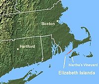
s extending southwest from the southern coast of Cape Cod
Cape Cod
Cape Cod, often referred to locally as simply the Cape, is a cape in the easternmost portion of the state of Massachusetts, in the Northeastern United States...
, Massachusetts
Massachusetts
The Commonwealth of Massachusetts is a state in the New England region of the northeastern United States of America. It is bordered by Rhode Island and Connecticut to the south, New York to the west, and Vermont and New Hampshire to the north; at its east lies the Atlantic Ocean. As of the 2010...
in the United States
United States
The United States of America is a federal constitutional republic comprising fifty states and a federal district...
. They are located at the outer edge of Buzzards Bay
Buzzards Bay (bay)
Buzzards Bay is a bay of the Atlantic Ocean adjacent to the U.S. state of Massachusetts. It is approximately 28 miles long by 8 miles wide. It is a popular destination for fishing, boating, and tourism. Since 1914, Buzzards Bay has been connected to Cape Cod Bay by the Cape Cod Canal...
, north of Martha's Vineyard
Martha's Vineyard
Martha's Vineyard is an island located south of Cape Cod in Massachusetts, known for being an affluent summer colony....
from which they are separated by Vineyard Sound
Vineyard Sound
Vineyard Sound is the stretch of the Atlantic Ocean which separates the Elizabeth Islands and the southwestern part of Cape Cod from the island of Martha's Vineyard, offshore from the state of Massachusetts in the USA...
, and constitute the town of Gosnold, Massachusetts
Gosnold, Massachusetts
Gosnold is a town that encompasses the Elizabeth Islands in Dukes County, Massachusetts, United States. As of the 2010 census, the town population was 75, making it the least populous town in Massachusetts...
in Dukes County
Dukes County, Massachusetts
-Demographics:As of the census of 2000, there were 14,987 people, 6,421 households, and 3,788 families residing in the county. The population density was 144 people per square mile . There were 14,836 housing units at an average density of 143 per square mile...
. All of the Elizabeth Islands except Cuttyhunk
Cuttyhunk
Cuttyhunk Island is the outermost of the Elizabeth Islands in Massachusetts. It was the first site of English settlement in New England. It is located between Buzzards Bay to the north and Vineyard Sound to the south...
and Penikese are privately owned by the Forbes family
Forbes family
The Forbes family is a wealthy extended American family originating in Boston. The family's fortune originates from trading between North America and China in the 19th century plus other investments in the same period. The name descends from Scottish immigrants, and can be traced back to Sir John...
.
The islands were claimed by England
English colonial empire
The English colonial empire consisted of a variety of overseas territories colonized, conquered, or otherwise acquired by the former Kingdom of England between the late 16th and early 18th centuries....
and named after Queen Elizabeth I
Elizabeth I of England
Elizabeth I was queen regnant of England and Ireland from 17 November 1558 until her death. Sometimes called The Virgin Queen, Gloriana, or Good Queen Bess, Elizabeth was the fifth and last monarch of the Tudor dynasty...
. In 1641, Thomas Mayhew Sr. of Watertown, Massachusetts
Watertown, Massachusetts
The Town of Watertown is a city in Middlesex County, Massachusetts, United States. The population was 31,915 at the 2010 census.- History :Archeological evidence suggests that Watertown was inhabited for thousands of years before the arrival of settlers from England...
, bought the islands (along with Nantucket and Martha's Vineyard) from William Alexander, the Earl of Sterling. Before the creation of the Province of Massachusetts Bay
Province of Massachusetts Bay
The Province of Massachusetts Bay was a crown colony in North America. It was chartered on October 7, 1691 by William and Mary, the joint monarchs of the kingdoms of England and Scotland...
in 1691, the islands were part of the extinct Dukes County, New York
Dukes County, New York
Dukes County, New York was a county of the New York from 1683 to 1691. It was formed on November 1, 1683, at the same time as Kings County, Queens County, and Duchess County. It consisted of the Elizabeth Islands, Martha's Vineyard, and Nantucket Island, all beyond the eastern end of Long Island...
. The total land area of the islands is 34.55 km² (13.34 sq mi) and there was a permanent population of 86 persons as of the 2000 census
United States Census, 2000
The Twenty-second United States Census, known as Census 2000 and conducted by the Census Bureau, determined the resident population of the United States on April 1, 2000, to be 281,421,906, an increase of 13.2% over the 248,709,873 persons enumerated during the 1990 Census...
.
Named islands
Stretching south-west from land's end at Falmouth, MassachusettsMassachusetts
The Commonwealth of Massachusetts is a state in the New England region of the northeastern United States of America. It is bordered by Rhode Island and Connecticut to the south, New York to the west, and Vermont and New Hampshire to the north; at its east lies the Atlantic Ocean. As of the 2010...
, the islands are:
- Nonamesset IslandNonamesset IslandNonamesset Island is the most easterly of the Elizabeth Islands of Dukes County, Massachusetts, USA. The island has a land area of 1.398 km² and was uninhabited as of the 2000 census. The island is part of the town of Gosnold, Massachusetts....
, the closest to the mainland - VeckatimestVeckatimest IslandVeckatimest Island is one of the Elizabeth Islands, part of the town of Gosnold in Dukes County, Massachusetts, USA. The island has a land area of 0.0675 km² and was uninhabited as of the 2000 census....
small island. - Uncatena IslandUncatena IslandUncatena Island is one of the Elizabeth Islands of Dukes County, Massachusetts, USA. It is the most northerly of the Elizabeth Islands and lies just northeast of the largest island, Naushon Island. Uncatena has a land area of 0.492 km² , and was uninhabited as of the 2000 census....
, uninhabited as of the 2000 Census - Naushon IslandNaushon IslandNaushon Island, part of the Elizabeth Islands, is seven miles long, just off Cape Cod, and four statute miles NW of Martha's Vineyard. The island is owned by the Forbes family and is included in the town of Gosnold, Massachusetts...
, 5.5 miles (8.9 km) long and the largest. Owned by the Forbes' Naushon Island Trust, and while it is not generally open to the public, the Forbes family has set aside Tarpaulin Cove to the south, Kettle Cove to the north, and Hadley's Harbor to the northeast for public enjoyment. - The Weepecket IslandsWeepecket IslandsThe Weepecket Islands are a group of three islands which are part of the Elizabeth Islands of Dukes County, Massachusetts, USA. They are located off the north shore of Naushon Island, the largest of the Elizabeth Islands. Together the three Weepeckets have a land area of 0.051 km²...
, three small, publicly accessible islands north of central Naushon owned by the Forbes family. These islands offer very few places to land, are nearly obscured by water, and are home to numerous shore birds, seals and other animals. - Pasque IslandPasque IslandPasque Island is one of the Elizabeth Islands of Dukes County, Massachusetts, USA. It lies between Nashawena Island to the west and Naushon Island to the east. The island has a land area of 3.45 km² and had a population of 2 persons as of the 2000 census. The island is part of the town of...
, 1.5 miles (2.4 km) long, owned by a subset of the Forbes family, and covered in poison ivyPoison ivyToxicodendron radicans, better known as poison ivy , is a poisonous North American plant that is well known for its production of urushiol, a clear liquid compound found within the sap of the plant that causes an itching rash in most people who touch it...
. A shallow tidal creek cuts part way through the island. - Nashawena IslandNashawena IslandNashawena Island is the second largest of the Elizabeth Islands of Dukes County, Massachusetts, USA. It lies between Cuttyhunk Island to the west and Pasque Island to the east. The island has a land area of 7.076 km² and an official permanent population of 2 persons as of the 2000 census. ...
, 3 miles (4.8 km) long, owned by another subset of the Forbes family, it has grazing livestock. - Penikese, located about 0.5 mile (0.80467 km) north of Nashawena and Cuttyhunk. Penikese is owned by the Commonwealth of Massachusetts and has a colorful history. It was the site of a groundbreaking 19th-century research facility that was the precursor to the famed Marine Biological Laboratory (MBL) in Woods Hole, was the site of the state's only leper colony in the early 20th century, and is currently a bird sanctuary and site of the Penikese Island School, an innovative, 35-year-old school for troubled teens.
- CuttyhunkCuttyhunkCuttyhunk Island is the outermost of the Elizabeth Islands in Massachusetts. It was the first site of English settlement in New England. It is located between Buzzards Bay to the north and Vineyard Sound to the south...
farthest west in the chain, and home to most of Gosnold's municipal population. Like Penikese, Cuttyhunk is not owned by the Forbes family, and therefore much of the island is publicly accessible.
Named channels and harbors
Channels with strong tidal currents, known locally as holes, separate the islands from each other and the mainland. Currents of up to 6 knots are driven by the different sizes and filling rates of Vineyard Sound to the southeast and Buzzard's Bay to the northwest. At high tide, water flows from Buzzards Bay to the Vineyard Sound. Near mid-tide the water stops and reverses, filling the Bay at low tide.Listed in order away from Falmouth, the named channels are:
- Woods Hole separating the mainland from Nonamesset Island
- Robinson Hole between Naushon Island and Pasque Island
- Quick's Hole between Pasque Island and Nashawena Island
- Canapitsit ChannelCanapitsit ChannelCanapitsit Channel is a channel that separates Nashawena Island from Cuttyhunk Island, two of the Elizabeth Islands off Cape Cod, Massachusetts. It is one of four straits allowing maritime passage between Buzzards Bay and the Vineyard Sound. The others are Quick's Hole, Robinson's Hole and Woods...
between Nashawena Island and Cuttyhunk Island.
Cuttyhunk Harbor is sheltered on its east by Nashawena Island on its west by Cuttyhunk Island and on its north by Penikese Island.
External links
- Cuttyhunk Historical Society, the Museum of the Elizabeth Islands The purpose of the Cuttyhunk Historical Society is to preserve the traditions, records and history of the Elizabeth Islands for the benefit of present and future generations.