
Eastham, Massachusetts
Encyclopedia
Eastham is a town
in Barnstable County
, Massachusetts
, United States
, Barnstable County being coextensive with Cape Cod
. The population was 5,453 at the 2000 census.
For geographic and demographic information about the village of North Eastham, please see North Eastham, Massachusetts
.
tribe, Eastham was the site where in 1621 a hunting expedition comprised from the crew of the sailing vessel Mayflower
, which had stopped in Provincetown harbor on Cape Cod Bay after a rough crossing of the Atlantic Ocean, which led to the first encounter of the Pilgrims and the local Nauset
Indians at First Encounter Beach. The area would not be settled by Europeans, however, until 1644. The original lands included what are now the towns of Truro
, Wellfleet
, Eastham, Orleans
and a small portion of Chatham
. Eastham town was officially incorporated in 1651. Birthplace of Freeman Hatch, who in 1853 set the world record (which still stands) for a single-hull wooden sailing vessel from San Francisco around Cape Horn to Boston aboard the clipper ship Northern Light. Fishing and especially farming were early industries in the town, and writers and artists also came to the town. In fact, it was in Eastham that Henry Beston
wrote The Outermost House
. The town is discussed at some length in Henry David Thoreau's
Cape Cod as the somewhat rugged site of one of New England's largest summer "camp-meeting" evangelistic gatherings in the mid-19th century. The gatherings were at times attended by at least "one hundred and fifty ministers, (!) and five thousand hearers" at a site called Millennium Grove, in the northwest part of town. (The area is now a residential neighborhood, the only reminder being Millennium Lane.)
Today, Eastham is mostly known as the "Gate" to the Cape Cod National Seashore
, which was founded in 1961 by President John F. Kennedy
to protect Cape Cod's coast from erosion and overpopulation. The town is the site of many beaches, both on the Atlantic and bay sides, as well as the Nauset Light, which was moved to the town in 1923 from its old location in Chatham, and the Three Sisters Lighthouses, which have since been moved away from their now-eroded perches on the coast to a field just west of Nauset Light.
, the town has a total area of 27.2 square miles (70.4 km²), of which, 14 square miles (36.3 km²) of it is land and 13.3 square miles (34.4 km²) of it (48.66%) is water. It is bordered by Cape Cod Bay
and the Atlantic Ocean
on its western and eastern sides, respectively. Eastham is also bordered by the towns of Wellfleet
and Orleans
on its northern and southern sides, respectively. Eastham is located on the "forearm" of Cape Cod, and is twenty-three miles south of Provincetown
and east-northeast of Barnstable
, thirty-eight miles east of the Sagamore Bridge
, and ninety-two miles (by land) southeast of Boston.
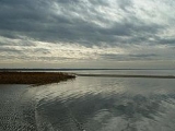
Approximately one-third of the town is located within the Cape Cod National Seashore
. There are several freshwater ponds near the center of town, the largest being called Great Pond, which has two public beaches. Powerboats with 50 and under horsepower motors are allowed on Great Pond and Herring Pond, with water skiing only permitted at Great Pond on even numbered days. Along the Atlantic coast, portions of the CCNS include several islands, divided by channels which lead from Nauset Bay and Salt Pond Bay to the ocean. The town also shares Town Cove with neighboring Orleans. Also, several creeks and the Herring River run inland from the bay side.
passes from south to north through the town. The Cape Cod Rail Trail, as well as several other bicycle routes, pass through the town. There is no rail or air service in town; the nearest regional air service is at the Chatham Regional Airport, though better and more regularly scheduled air service between the Cape and Boston can be found in Provincetown and Hyannis through Cape Air, and the nearest national and international air service can be found at Logan International Airport
in Boston. Eastham is also serviced by an inexpensive regional bus service, The Flex.
of 2000, there were 5,453 people, 2,396 households, and 1,634 families residing in the town. The population density
was 389.8 people per square mile (150.5/km²). There were 5,535 housing units at an average density of 395.6 per square mile (152.8/km²). The racial makeup of the town was 96.31% White, 1.49% African American, 0.15% Native American, 0.31% Asian, 0.04% Pacific Islander, 0.29% from other races
, and 1.41% from two or more races. Hispanic or Latino of any race were 0.83% of the population.
There were 2,396 households out of which 21.9% had children under the age of 18 living with them, 55.0% were married couples
living together, 9.9% had a female householder with no husband present, and 31.8% were non-families. 25.5% of all households were made up of individuals and 12.4% had someone living alone who was 65 years of age or older. The average household size was 2.24 and the average family size was 2.66.
In the town the population was spread out with 17.7% under the age of 18, 5.0% from 18 to 24, 23.7% from 25 to 44, 27.6% from 45 to 64, and 26.0% who were 65 years of age or older. The median age was 48 years. For every 100 females there were 93.6 males. For every 100 females age 18 and over, there were 89.0 males.
The median income for a household in the town was $42,618, and the median income for a family was $51,269. Males had a median income of $36,642 versus $32,109 for females. The per capita income
for the town was $24,642. About 4.5% of families and 7.0% of the population were below the poverty line, including 6.5% of those under age 18 and 7.3% of those age 65 or over.
as a part of the Fourth Barnstable district, which includes (with the exception of Brewster) all the towns east and north of Harwich on the Cape. The town is represented in the Massachusetts Senate
as a part of the Cape and Islands District, which includes all of Cape Cod, Martha's Vineyard and Nantucket except the towns of Bourne, Falmouth, Sandwich and a portion of Barnstable. The town is patrolled by the Second (Yarmouth) Barracks of Troop D of the Massachusetts State Police
.
On the national level, Eastham is a part of Massachusetts's 10th congressional district
, and is currently represented by Bill Delahunt
. The state's senior member of the United States Senate
, re-elected in 2008, is John Kerry
. The junior Senator, elected in a special election in January 2010, is Scott Brown
.
Eastham is governed by the open town meeting
form of government, and is led by a town administrator and a board of selectmen
. The town hall, police and fire department headquarters are all located along Route 6 across from Windmill Park. The Eastham Public Library
is located just west of the park, along Samoset Road (which leads from Route 6 to First Encounter Beach). There are separate post offices for Eastham and the village of North Eastham, both of which are located along Route 6 (the former being just across from the town hall, south of the park).
is located in North Eastham, on the edge of the Cape Cod National Seashore. The school's teams are known as the Warriors, and their colors are black and gold. Due to controversy, the Nauset Indian logo for the school has been revoked, but there are rumors that it will be reinstated. High school students also have the option of attending Cape Cod Regional Technical High School in Harwich free of charge. There are no private schools in Eastham; the nearest are in Brewster.
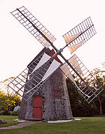 Eastham is home to a number of sites that are listed on the National Register of Historic Places
. The Eastham Center Historic District, located near Town Hall, is the site of Eastham Windmill
, the oldest windmill
on Cape Cod. Another registered historic place, Nauset Light, is located on the grounds of the Cape Cod National Seashore
. The Edward Penniman House and barn, a retired whaling captain's home, is located near Fort Hill.
New England town
The New England town is the basic unit of local government in each of the six New England states. Without a direct counterpart in most other U.S. states, New England towns are conceptually similar to civil townships in other states, but are incorporated, possessing powers like cities in other...
in Barnstable County
Barnstable County, Massachusetts
Barnstable County is a county located in the U.S. state of Massachusetts, consisting of Cape Cod and associated islands. As of the 2010 census, the population was 216,902...
, Massachusetts
Massachusetts
The Commonwealth of Massachusetts is a state in the New England region of the northeastern United States of America. It is bordered by Rhode Island and Connecticut to the south, New York to the west, and Vermont and New Hampshire to the north; at its east lies the Atlantic Ocean. As of the 2010...
, United States
United States
The United States of America is a federal constitutional republic comprising fifty states and a federal district...
, Barnstable County being coextensive with Cape Cod
Cape Cod
Cape Cod, often referred to locally as simply the Cape, is a cape in the easternmost portion of the state of Massachusetts, in the Northeastern United States...
. The population was 5,453 at the 2000 census.
For geographic and demographic information about the village of North Eastham, please see North Eastham, Massachusetts
North Eastham, Massachusetts
North Eastham is a census-designated place in the town of Eastham in Barnstable County, Massachusetts, United States. The population was 1,915 at the 2000 census.The main visitor center of the Cape Cod National Seashore is located in North Eastham....
.
History
Originally settled by the NausetNauset
The Nauset tribe, sometimes referred to as the Cape Cod Indians lived in what is present-day Cape Cod, Massachusetts, living east of Bass River and lands occupied by their closely related neighbours, the Wampanoag...
tribe, Eastham was the site where in 1621 a hunting expedition comprised from the crew of the sailing vessel Mayflower
Mayflower
The Mayflower was the ship that transported the English Separatists, better known as the Pilgrims, from a site near the Mayflower Steps in Plymouth, England, to Plymouth, Massachusetts, , in 1620...
, which had stopped in Provincetown harbor on Cape Cod Bay after a rough crossing of the Atlantic Ocean, which led to the first encounter of the Pilgrims and the local Nauset
Nauset
The Nauset tribe, sometimes referred to as the Cape Cod Indians lived in what is present-day Cape Cod, Massachusetts, living east of Bass River and lands occupied by their closely related neighbours, the Wampanoag...
Indians at First Encounter Beach. The area would not be settled by Europeans, however, until 1644. The original lands included what are now the towns of Truro
Truro, Massachusetts
Truro is a town in Barnstable County, Massachusetts, United States, comprising two villages: Truro and North Truro. Located two hours outside Boston, it is a summer vacation community just south of the northern tip of Cape Cod, in an area known as the "Outer Cape"...
, Wellfleet
Wellfleet, Massachusetts
Wellfleet is a New England town in Barnstable County, Massachusetts, United States. Located halfway between the "tip" and "elbow" of Cape Cod, Massachusetts, the town had a population of 2,749 at the 2000 census, which swells nearly sixfold during the summer...
, Eastham, Orleans
Orleans, Massachusetts
Orleans is a town in Barnstable County, Massachusetts, United States. Barnstable County is coextensive with Cape Cod. The population was 5,890 at the 2010 census....
and a small portion of Chatham
Chatham, Massachusetts
Chatham is a town in Barnstable County, Massachusetts, United States, Barnstable County being coextensive with Cape Cod. The population was 6,625 at the 2000 census...
. Eastham town was officially incorporated in 1651. Birthplace of Freeman Hatch, who in 1853 set the world record (which still stands) for a single-hull wooden sailing vessel from San Francisco around Cape Horn to Boston aboard the clipper ship Northern Light. Fishing and especially farming were early industries in the town, and writers and artists also came to the town. In fact, it was in Eastham that Henry Beston
Henry Beston
Henry Beston was an American writer and naturalist, best known as the author of The Outermost House, written in 1925.-Early life and work:...
wrote The Outermost House
The Outermost House
The Outermost House is a book by naturalist writer Henry Beston. It was published in 1928 by Doubleday and Doran and is now published by Henry Holt and Company in New York...
. The town is discussed at some length in Henry David Thoreau's
Henry David Thoreau
Henry David Thoreau was an American author, poet, philosopher, abolitionist, naturalist, tax resister, development critic, surveyor, historian, and leading transcendentalist...
Cape Cod as the somewhat rugged site of one of New England's largest summer "camp-meeting" evangelistic gatherings in the mid-19th century. The gatherings were at times attended by at least "one hundred and fifty ministers, (!) and five thousand hearers" at a site called Millennium Grove, in the northwest part of town. (The area is now a residential neighborhood, the only reminder being Millennium Lane.)
Today, Eastham is mostly known as the "Gate" to the Cape Cod National Seashore
Cape Cod National Seashore
The Cape Cod National Seashore , created on August 7, 1961 by President John F. Kennedy, encompasses on Cape Cod, Massachusetts. It includes ponds, woods and beachfront of the Atlantic coastal pine barrens ecoregion...
, which was founded in 1961 by President John F. Kennedy
John F. Kennedy
John Fitzgerald "Jack" Kennedy , often referred to by his initials JFK, was the 35th President of the United States, serving from 1961 until his assassination in 1963....
to protect Cape Cod's coast from erosion and overpopulation. The town is the site of many beaches, both on the Atlantic and bay sides, as well as the Nauset Light, which was moved to the town in 1923 from its old location in Chatham, and the Three Sisters Lighthouses, which have since been moved away from their now-eroded perches on the coast to a field just west of Nauset Light.
Geography
According to the United States Census BureauUnited States Census Bureau
The United States Census Bureau is the government agency that is responsible for the United States Census. It also gathers other national demographic and economic data...
, the town has a total area of 27.2 square miles (70.4 km²), of which, 14 square miles (36.3 km²) of it is land and 13.3 square miles (34.4 km²) of it (48.66%) is water. It is bordered by Cape Cod Bay
Cape Cod Bay
Cape Cod Bay is a large bay of the Atlantic Ocean adjacent to the U.S. state of Massachusetts. Measuring below a line drawn from Brant Rock in Marshfield to Race Point in Provincetown, Massachusetts, it is enclosed by Cape Cod to the south and east, and Plymouth County, Massachusetts, to the west....
and the Atlantic Ocean
Atlantic Ocean
The Atlantic Ocean is the second-largest of the world's oceanic divisions. With a total area of about , it covers approximately 20% of the Earth's surface and about 26% of its water surface area...
on its western and eastern sides, respectively. Eastham is also bordered by the towns of Wellfleet
Wellfleet, Massachusetts
Wellfleet is a New England town in Barnstable County, Massachusetts, United States. Located halfway between the "tip" and "elbow" of Cape Cod, Massachusetts, the town had a population of 2,749 at the 2000 census, which swells nearly sixfold during the summer...
and Orleans
Orleans, Massachusetts
Orleans is a town in Barnstable County, Massachusetts, United States. Barnstable County is coextensive with Cape Cod. The population was 5,890 at the 2010 census....
on its northern and southern sides, respectively. Eastham is located on the "forearm" of Cape Cod, and is twenty-three miles south of Provincetown
Provincetown, Massachusetts
Provincetown is a New England town located at the extreme tip of Cape Cod in Barnstable County, Massachusetts, United States. The population was 3,431 at the 2000 census, with an estimated 2007 population of 3,174...
and east-northeast of Barnstable
Barnstable, Massachusetts
Barnstable is a city, referred to as the Town of Barnstable, in the U.S. state of Massachusetts and the county seat of Barnstable County. Barnstable is the largest community, both in land area and population, on Cape Cod. The town contains seven villages within its boundaries...
, thirty-eight miles east of the Sagamore Bridge
Sagamore Bridge
The Sagamore Bridge in Sagamore, Massachusetts carries U.S. Route 6 across the Cape Cod Canal, connecting Cape Cod with the rest of Massachusetts, USA....
, and ninety-two miles (by land) southeast of Boston.
Approximately one-third of the town is located within the Cape Cod National Seashore
Cape Cod National Seashore
The Cape Cod National Seashore , created on August 7, 1961 by President John F. Kennedy, encompasses on Cape Cod, Massachusetts. It includes ponds, woods and beachfront of the Atlantic coastal pine barrens ecoregion...
. There are several freshwater ponds near the center of town, the largest being called Great Pond, which has two public beaches. Powerboats with 50 and under horsepower motors are allowed on Great Pond and Herring Pond, with water skiing only permitted at Great Pond on even numbered days. Along the Atlantic coast, portions of the CCNS include several islands, divided by channels which lead from Nauset Bay and Salt Pond Bay to the ocean. The town also shares Town Cove with neighboring Orleans. Also, several creeks and the Herring River run inland from the bay side.
Transportation
U.S. Route 6U.S. Route 6
U.S. Route 6 , also called the Grand Army of the Republic Highway, a name that honors an American Civil War veterans association, is a main route of the U.S. Highway system, running east-northeast from Bishop, California to Provincetown, Massachusetts. Until 1964, it continued south from Bishop to...
passes from south to north through the town. The Cape Cod Rail Trail, as well as several other bicycle routes, pass through the town. There is no rail or air service in town; the nearest regional air service is at the Chatham Regional Airport, though better and more regularly scheduled air service between the Cape and Boston can be found in Provincetown and Hyannis through Cape Air, and the nearest national and international air service can be found at Logan International Airport
Logan International Airport
General Edward Lawrence Logan International Airport is located in the East Boston neighborhood of Boston, Massachusetts . It covers , has six runways, and employs an estimated 16,000 people. It is the 19th busiest airport in the United States.Boston serves as a focus city for JetBlue Airways...
in Boston. Eastham is also serviced by an inexpensive regional bus service, The Flex.
Demographics
As of the censusCensus
A census is the procedure of systematically acquiring and recording information about the members of a given population. It is a regularly occurring and official count of a particular population. The term is used mostly in connection with national population and housing censuses; other common...
of 2000, there were 5,453 people, 2,396 households, and 1,634 families residing in the town. The population density
Population density
Population density is a measurement of population per unit area or unit volume. It is frequently applied to living organisms, and particularly to humans...
was 389.8 people per square mile (150.5/km²). There were 5,535 housing units at an average density of 395.6 per square mile (152.8/km²). The racial makeup of the town was 96.31% White, 1.49% African American, 0.15% Native American, 0.31% Asian, 0.04% Pacific Islander, 0.29% from other races
Race (United States Census)
Race and ethnicity in the United States Census, as defined by the Federal Office of Management and Budget and the United States Census Bureau, are self-identification data items in which residents choose the race or races with which they most closely identify, and indicate whether or not they are...
, and 1.41% from two or more races. Hispanic or Latino of any race were 0.83% of the population.
There were 2,396 households out of which 21.9% had children under the age of 18 living with them, 55.0% were married couples
Marriage
Marriage is a social union or legal contract between people that creates kinship. It is an institution in which interpersonal relationships, usually intimate and sexual, are acknowledged in a variety of ways, depending on the culture or subculture in which it is found...
living together, 9.9% had a female householder with no husband present, and 31.8% were non-families. 25.5% of all households were made up of individuals and 12.4% had someone living alone who was 65 years of age or older. The average household size was 2.24 and the average family size was 2.66.
In the town the population was spread out with 17.7% under the age of 18, 5.0% from 18 to 24, 23.7% from 25 to 44, 27.6% from 45 to 64, and 26.0% who were 65 years of age or older. The median age was 48 years. For every 100 females there were 93.6 males. For every 100 females age 18 and over, there were 89.0 males.
The median income for a household in the town was $42,618, and the median income for a family was $51,269. Males had a median income of $36,642 versus $32,109 for females. The per capita income
Per capita income
Per capita income or income per person is a measure of mean income within an economic aggregate, such as a country or city. It is calculated by taking a measure of all sources of income in the aggregate and dividing it by the total population...
for the town was $24,642. About 4.5% of families and 7.0% of the population were below the poverty line, including 6.5% of those under age 18 and 7.3% of those age 65 or over.
Government
Eastham is represented in the Massachusetts House of RepresentativesMassachusetts House of Representatives
The Massachusetts House of Representatives is the lower house of the Massachusetts General Court, the state legislature of the Commonwealth of Massachusetts. It is composed of 160 members elected from single-member electoral districts across the Commonwealth. Representatives serve two-year terms...
as a part of the Fourth Barnstable district, which includes (with the exception of Brewster) all the towns east and north of Harwich on the Cape. The town is represented in the Massachusetts Senate
Massachusetts Senate
The Massachusetts Senate is the upper house of the Massachusetts General Court, the bicameral state legislature of the Commonwealth of Massachusetts. The Senate comprises 40 elected members from 40 single-member senatorial districts in the state...
as a part of the Cape and Islands District, which includes all of Cape Cod, Martha's Vineyard and Nantucket except the towns of Bourne, Falmouth, Sandwich and a portion of Barnstable. The town is patrolled by the Second (Yarmouth) Barracks of Troop D of the Massachusetts State Police
Massachusetts State Police
The Massachusetts State Police is an agency of the Commonwealth of Massachusetts' Executive Office of Public Safety and Security responsible for criminal law enforcement and traffic vehicle regulation across the state...
.
On the national level, Eastham is a part of Massachusetts's 10th congressional district
Massachusetts's 10th congressional district
Massachusetts's 10th congressional district is a political constituency that includes parts of the South Shore of Massachusetts, and all of Cape Cod and the islands. With a population of 635,901 and a land area of , it is the most populous of Massachusetts's ten congressional districts and the...
, and is currently represented by Bill Delahunt
Bill Delahunt
William D. Delahunt is a former U.S. Representative for , serving from 1997 to 2011. He is a member of the Democratic Party. Delahunt did not seek re-election in 2010, and left Congress in January 2011. He was replaced by Norfolk County District Attorney Bill Keating...
. The state's senior member of the United States Senate
United States Senate
The United States Senate is the upper house of the bicameral legislature of the United States, and together with the United States House of Representatives comprises the United States Congress. The composition and powers of the Senate are established in Article One of the U.S. Constitution. Each...
, re-elected in 2008, is John Kerry
John Kerry
John Forbes Kerry is the senior United States Senator from Massachusetts, the 10th most senior U.S. Senator and chairman of the Senate Foreign Relations Committee. He was the presidential nominee of the Democratic Party in the 2004 presidential election, but lost to former President George W...
. The junior Senator, elected in a special election in January 2010, is Scott Brown
Scott Brown
Scott Brown is a United States senator.Scott Brown may also refer to:-Sportsmen:*Scott Brown , American college football coach of Kentucky State...
.
Eastham is governed by the open town meeting
Open town meeting
An open town meeting is a form of town meeting in which all registered voters of a town may vote . This form of government is typical of smaller municipalities in the New England region of the United States....
form of government, and is led by a town administrator and a board of selectmen
Board of selectmen
The board of selectmen is commonly the executive arm of the government of New England towns in the United States. The board typically consists of three or five members, with or without staggered terms.-History:...
. The town hall, police and fire department headquarters are all located along Route 6 across from Windmill Park. The Eastham Public Library
Eastham Public Library
Eastham Public Library is the public library of Eastham, Massachusetts that has been serving the community for over 130 years. It provides a collection of print, non-print, and electronic resources for the community...
is located just west of the park, along Samoset Road (which leads from Route 6 to First Encounter Beach). There are separate post offices for Eastham and the village of North Eastham, both of which are located along Route 6 (the former being just across from the town hall, south of the park).
Education
Eastham, along with Brewster, Orleans and Wellfleet, make up the Nauset Regional School District. Each town is responsible for operating its own elementary schools, with the middle and high school students attending regional schools. Eastham Elementary School serves students from kindergarten through fifth grade, and is located near the CCNS Visitor Center and the Schoolhouse Museum. Middle school students attend the Nauset Regional Middle School in Orleans, and the Nauset Regional High SchoolNauset Regional High School
Nauset Regional High School an NEASC accredited High School located in North Eastham, Massachusetts. Nauset is the only high school on the East Coast located within a National Park. . The open campus is situated about a half-mile from Nauset Lighthouse...
is located in North Eastham, on the edge of the Cape Cod National Seashore. The school's teams are known as the Warriors, and their colors are black and gold. Due to controversy, the Nauset Indian logo for the school has been revoked, but there are rumors that it will be reinstated. High school students also have the option of attending Cape Cod Regional Technical High School in Harwich free of charge. There are no private schools in Eastham; the nearest are in Brewster.
Landmarks
National Register of Historic Places
The National Register of Historic Places is the United States government's official list of districts, sites, buildings, structures, and objects deemed worthy of preservation...
. The Eastham Center Historic District, located near Town Hall, is the site of Eastham Windmill
Eastham Windmill
The Eastham Windmill, located in Eastham, Massachusetts, is the oldest windmill on Cape Cod. It was constructed by Eastham resident Thomas Paine in Plymouth in 1680. It was first moved to nearby Truro in 1770, then finally to Eastham in 1793. In 1808 the windmill was moved to its present...
, the oldest windmill
Windmill
A windmill is a machine which converts the energy of wind into rotational energy by means of vanes called sails or blades. Originally windmills were developed for milling grain for food production. In the course of history the windmill was adapted to many other industrial uses. An important...
on Cape Cod. Another registered historic place, Nauset Light, is located on the grounds of the Cape Cod National Seashore
Cape Cod National Seashore
The Cape Cod National Seashore , created on August 7, 1961 by President John F. Kennedy, encompasses on Cape Cod, Massachusetts. It includes ponds, woods and beachfront of the Atlantic coastal pine barrens ecoregion...
. The Edward Penniman House and barn, a retired whaling captain's home, is located near Fort Hill.