
Earthquakes in Iran
Encyclopedia
Iran
Iran , officially the Islamic Republic of Iran , is a country in Southern and Western Asia. The name "Iran" has been in use natively since the Sassanian era and came into use internationally in 1935, before which the country was known to the Western world as Persia...
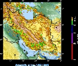
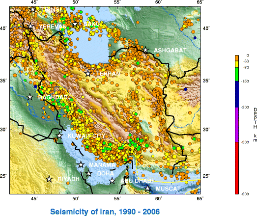
is one of the most seismically active countries in the world, being crossed by several major fault lines that cover at least 90% of the country. As a result, earthquakes in Iran occur often and are destructive.
Geology and history
The Iranian plateauIranian plateau
The Iranian plateau, or Iranic plateau, is a geological formation in Southwest Asia. It is the part of the Eurasian Plate wedged between the Arabian and Indian plates, situated between the Zagros mountains to the west, the Caspian Sea and the Kopet Dag to the north, the Hormuz Strait and Persian...
is subject to most types of tectonic activity, including active folding
Fold (geology)
The term fold is used in geology when one or a stack of originally flat and planar surfaces, such as sedimentary strata, are bent or curved as a result of permanent deformation. Synsedimentary folds are those due to slumping of sedimentary material before it is lithified. Folds in rocks vary in...
, faulting and volcanic
Volcano
2. Bedrock3. Conduit 4. Base5. Sill6. Dike7. Layers of ash emitted by the volcano8. Flank| 9. Layers of lava emitted by the volcano10. Throat11. Parasitic cone12. Lava flow13. Vent14. Crater15...
eruptions. It is well known for its long history of disastrous earthquake activity. Not only have these earthquakes killed thousands, but they have also led to waste of valuable natural resources. Since 1900, at least 126,000 fatalities have resulted from earthquakes in Iran.
21st century
| Date | Time | Epicenter | Magnitude | Fatalities | Coordinates | Official title |
|---|---|---|---|---|---|---|
| Jun 15, 2011 | 01:05:30 | Kahnooj | 5.3 | 2 | 27.976°N 57.574°E | 2011 Kahnooj earthquake |
| Dec 20, 2010 | 22:12:01 | Hosseinabad | 6.5 | 11 | 28.491°N 59.117°E | 2010 Hosseinabad earthquake 2010 Hosseinabad earthquake The 2010 Hosseinabad earthquake occurred on December 20, 2010 at 22:11 local time . It was a magnitude 6.5 earthquake that was located about 20 km from Hosseinabad , Kermān Province in south-eastern Iran, about 100 km from Bam.The earthquake killed eleven people and injured over 100... |
| Aug 27, 2010 | 23:56:34 | Damghan Damghan Damghan is a city in and capital of Damghan County, Semnan Province, Iran. At the 2006 census, its population was 57,331, in 15,849 families.Damghan is situated from Tehran on the high-road to Mashad, at an elevation of... |
5.9 | 19 | 26°44′34.8"N 55°49′40.8"E | 2010 Damghan earthquake |
| Sep 10, 2008 | 11:00:34 | Qeshm Qeshm Qeshm Qeshm Qeshm (Persian: قشم - pronounced kē´shm is an Iranian island situated in the Strait of Hormuz, and separated from the mainland by the Clarence Strait/Khuran in the Persian Gulf .-Geography:... |
6.1 | 7 | 26°44′34.8"N 55°49′40.8"E | 2008 Bandar Abbas earthquake 2008 Bandar Abbas earthquake The 2008 Bandar Abbas earthquake occurred on September 10, 2008 in the Hormozgān Province of southern Iran, south of Tehran. Its epicenter was near the port city of Bandar Abbas, where an earthquake two years prior had caused damage. The earthquake measured 6.1 on the Moment magnitude scale and 6... |
| March 31, 2006 | 01:17:01 | Borujerd Borujerd Borujerd is a city in and capital of Borujerd County, Lorestan Province in western Iran. At the 2006 census, its population was 227,547, in 59,388 families.... |
6.1 | 70 | 33°34′51.6"N 48°47′38.4"E | 2006 Borujerd earthquake |
| November 27, 2005 | 10:22:19 | Qeshm Qeshm Qeshm Qeshm Qeshm (Persian: قشم - pronounced kē´shm is an Iranian island situated in the Strait of Hormuz, and separated from the mainland by the Clarence Strait/Khuran in the Persian Gulf .-Geography:... |
6.0 | 13 | 26°47′2.4"N 55°50′49.2"E | 2005 Qeshm earthquake |
| February 22, 2005 | 02:25:22 | Zarand Zarand, Iran Zarand is a city in and the capital of Zarand County, Kerman Province, Iran. At the 2006 census, its population was 54,745, in 12,992 families.It is located about northwest of the provincial capital of Kerman.... |
6.4 | At least 602 | 30°44′27.6"N 56°52′37.2"E | 2005 Zarand earthquake 2005 Zarand earthquake 2005 Zarand earthquake hit the city of Zarand and several villages in Kerman province of Iran on February 22, 2005. The earthquake happened at 5:55 local time and was measured at 6.4 on the Richter scale. The quake lasted for 11 seconds and at least 61 aftershocks were reported ranging in... |
| May 28, 2004 | 12:38:46 | Māzandarān | 6.3 | At least 35 | 36°16′12"N 51°34′30"E | 2004 Māzandarān earthquake |
| December 26, 2003 | 01:56:52 | Bam Bam, Iran Bam is a city in and the capital of Bam County, Kerman Province, Iran. At the 2006 census, its population was 73,823, in 19,572 families.The modern Iranian city of Bam surrounds the Bam citadel. Before the 2003 earthquake the official population count of the city was roughly 43,000. There are... |
6.6 | At least 30,000 | 29°0′14.4"N 58°20′13.2"E | 2003 Bam earthquake 2003 Bam earthquake The 2003 Bam earthquake was a major earthquake that struck Bam and the surroundingKerman province of southeastern Iran at 1:56 AM UTC on Friday, December 26, 2003. The most widely accepted estimate for the magnitude of the earthquake is a moment magnitude of 6.6; estimated by the United... |
| June 22, 2002 | 02:58:21 | Qazvin Qazvin Qazvin is the largest city and capital of the Province of Qazvin in Iran. At the 2006 census, its population was 349,821, in 96,420 families.... |
6.5 | 262 | 35°40′8.4"N 48°55′58.8"E | 2002 Bou'in-Zahra earthquake 2002 Bou'in-Zahra earthquake The 2002 Bou'in-Zahra earthquake occurred on June 22, 2002 in a region of northwestern Iran which is crossed by several major fault lines. The earthquake's epicenter was near the city of Bou'in-Zahra in Qazvin Province, an area known for destructive earthquakes... |

20th century
| Date | Time | Epicenter | Magnitude | Fatalities | Coordinates | Official title |
|---|---|---|---|---|---|---|
| March 14, 1998 | 19:40:02 | Golbaf Golbaf Golbaf is a city in and capital of Golbaf District, in Kerman County, Kerman Province, Iran. At the 2006 census, its population was 8,341, in 2,039 families.... |
6.6 | 5 | 30°9′N 57°36′E | 1998 Golbaf earthquake |
| May 10, 1997 | 07:57:29 | Birjand Birjand Birjand is the east Iranian provincial capital of South Khorasan and the centre of the county Birjand resp. Quhestan, known for its saffron, barberry, rug and handmade carpet exports.... -Qaen |
7.3 | 1,567 | 33°49′12"N 59°48′0"E | 1997 Qayen earthquake 1997 Qayen earthquake The Qayen earthquake, also known as the Ardekul or Qaen earthquake, was a major earthquake that struck Northern Iran's Khorasan Province on May 10, 1997. The largest in the area since 1990, it measured 7.3 on the moment magnitude scale and was centered approximately south of Mashhad on the village... |
| February 28, 1997 | Ardabil Ardabil Ardabil is a historical city in north-western Iran. The name Ardabil probably comes from the Zoroastrian name of "Artavil" which means a holy place. Ardabil is the center of Ardabil Province. At the 2006 census, its population was 412,669, in 102,818 families... |
6.0 | ||||
| 38°15′N 48°17′E | 1997 Ardabil earthquake 1997 Ardabil earthquake The 1997 Ardabil earthquake was a destructive earthquake that occurred on 28 February 1997. The epicenter was located near the city of Ardabil in northern Iran.-Background and tectonics:... |
|||||
| June 20, 1990 | Manjil Manjil Manjil is a city in the Central District of Rudbar County, Gilan Province, Iran. At the 2006 census, its population was 16,028, in 4,447 families.-History and Geography:Manjil is located between N36º45´18˝-N36º41´42˝ and E49º23´6˝ and E49º31´ 48˝... (-Rudbar Rudbar Rudbar is a city in and the capital of Rudbar County, Gilan Province, Iran. At the 2006 census, its population was 11,454, in 3,303 families.... ) |
7.4 | At least 40,000 | 37°0′N 49°24′E | 1990 Manjil-Rudbar earthquake 1990 Manjil-Rudbar earthquake The Manjil-Rudbar Earthquake occurred at 00:30:09 on June 21, 1990 . It caused widespread damage in areas within a one hundred kilometer radius of the epicenter near the city of Rasht and about two hundred kilometers northwest of Tehran. The cities of Rudbar, Manjil, and Lushan and 700 villages... |
|
| July 28, 1981 | Southern Iran | 7.3 | 1,500 | 30°0′N 57°48′E | July 1981 southern Iran earthquake | |
| June 11, 1981 | Southern Iran | 6.9 | 3,000 | 29°54′N 57°42′E | June 1981 southern Iran earthquake | |
| September 16, 1978 | Tabas Tabas Tabas is a city in and capital of Tabas County, Yazd Province, Iran. At the 2006 census, its population was 30,681, in 7,962 families.Tabas is located in central Iran, 950 kilometers southeast of Tehran, in Yazd Province. Formerly it was part of the Khorasan province. It is a desert city with... |
7.8 | 15,000 | 33°12′N 57°24′E | 1978 Tabas earthquake 1978 Tabas earthquake The 1978 Tabas earthquake was a huge earthquake measuring 7.8 on the Richter scale which struck on September 16, 1978 in central Iran. The death toll was approximately 15,000 and the worst damage was to the town Tabas, which was at the epicentre of the quake and completely flattened. 40 villages... |
|
| April 10, 1972 | 7.1 | 5,054 | 28°24′N 52°48′E | 1972 southern Iran earthquake | ||
| August 31, 1968 | Dasht-e-Bayaz-Ferdows Ferdows Ferdows , also Romanized as Ferdos, Ferdous, and Firdaus; named Toon or Tūn until 1929) is a city in and the capital of Ferdows County, located in the northwest of South Khorasan Province in Iran. It is about south of Mashhad and 200 km northwest of Birjand... |
7.3 | At least 7,000 | 33°54′0"N 59°1′12"E | 1968 Dasht-e Bayaz and Ferdows earthquake 1968 Dasht-e Bayaz and Ferdows earthquake Dasht-e Bayaz and Ferdows Earthquake, were two successive earthquakes, which hit Dashte Bayaz, Kakhk and Ferdows, Iran.The first earthquake occurred on August 31, 1968, measuring 7.3 on the Richter scale and destroyed 5 villages totally in the Dasht-e Bayaz area, and at least half of the buildings... |
|
| February 10, 1965 | 16:09 | Bostanabad-e Bala | 5.1 | 20 | 1965 Bostanabad-e Bala earthquake | |
| September 1, 1962 | Bou'in-Zahra | 7.1 | 12,225 | 35°36′N 49°54′E | 1962 Bou'in-Zahra earthquake 1962 Bou'in-Zahra earthquake The 1962 Bou'in-Zahra earthquake occurred on September 1, 1962, in the area of Bou'in-Zahra, Qazvin Province, Iran. 12,225 fatalities resulted from the massive, magnitude 7.1 earthquake.... |
|
| December 13, 1957 | Sahneh Sahneh Sahneh is a city in and the capital of Sahneh County, Kermanshah Province, Iran. At the 2006 census, its population was 34,133, in 8,861 families.... |
7.1 | 1,130 | 34°21′0"N 47°40′12"E | 1957 Sahneh earthquake | |
| July 2, 1957 | Māzandarān | 7.1 | 1,200 | 36°8′24"N 52°42′0"E | 1957 Māzandarān earthquake | |
| February 12, 1953 | Torud | 6.5 | 970 | 1953 Torud earthquake | ||
| August 5, 1947 | Pasni Pasni Pasni, the Weaning Ceremony is one in hundreds of celebrations in Nepal in which a child is first fed rice. Although centuries old tradition, modern science has established the fact that child's digestive system is capable of processing solid food when they are approximately 6 months old... |
7.3 | 1947 Pasni earthquake | |||
| May 6, 1930 | Salmas Salmas Salmas is a city in and the capital of Salmas County, West Azerbaijan Province, Iran. At the 2006 census, its population was 79,560, in 19,806 families.... |
7.2 | 2, 500 | 38°9′N 44°42′E | 1930 Salmas earthquake 1930 Salmas earthquake The 1930 Salmas earthquake occurred on May 6, 1930 in Salmas, Persia . Occurring about a year after the 1929 Baghan-Gifan earthquake, the earthquake measured 7.2 on the Richter scale and 7.4 surface wave magnitude and resulted in 2,500 direct fatalities. One foreshock occurred prior to the rupture,... |
|
| May 1, 1929 | Koppeh Dagh | 7.4 | 3,800 | 37°51′N 57°45′E | 1929 Koppeh Dagh earthquake | |
| May 25, 1923 | Torbat-e Heydariyeh | 5.7 | 2,200 | 33°24′N 59°6′E | 1923 Torbat-e Heydariyeh earthquake | |
| January 23, 1909 | Silakhor | 7.3 | 6,000 | 33°24′N 49°6′E | 1909 Silakhor earthquake 1909 Silakhor earthquake The 1909 Silakhor earthquake occurred in Silakhor plain , Persia on January 23, 1909. Around 8,000 fatalities were caused directly from the magnitude 7.3 earthquake. An indefinite number of aftershocks continued for six months after the main shock... |
Other
| Date | Time | Epicenter | Magnitude | Fatalities | Coordinates | Official title |
|---|---|---|---|---|---|---|
| June 7, 1755 | Kashan Kashan Kashan is a city in and the capital of Kashan County, in the province of Isfahan, Iran. At the 2006 census, its population was 248,789, in 67,464 families.... |
Unknown | 40,000 | 33°59′N 51°27′E | 1755 Kashan earthquake | |
| November 18, 1727 | Tabriz Tabriz Tabriz is the fourth largest city and one of the historical capitals of Iran and the capital of East Azerbaijan Province. Situated at an altitude of 1,350 meters at the junction of the Quri River and Aji River, it was the second largest city in Iran until the late 1960s, one of its former... |
Unknown | 77,000 | 38°5′N 46°17′E | 1727 Tabriz earthquake 1727 Tabriz earthquake The 1727 Tabriz earthquake occurred on 18 November with an epicenter near Tabriz. The maximum felt intensity was VIII on the Mercalli intensity scale, and there were an estimated 77,000 deaths. It is possible that the information for this earthquake refers to an event in Tabriz in 1721 instead.... |
|
| March 23, 893 | Ardabil Ardabil Ardabil is a historical city in north-western Iran. The name Ardabil probably comes from the Zoroastrian name of "Artavil" which means a holy place. Ardabil is the center of Ardabil Province. At the 2006 census, its population was 412,669, in 102,818 families... |
Unknown | 150,000 | 38°15′N 48°17′E | 893 Ardabil earthquake | |
| December 22, 856 | Damghan Damghan Damghan is a city in and capital of Damghan County, Semnan Province, Iran. At the 2006 census, its population was 57,331, in 15,849 families.Damghan is situated from Tehran on the high-road to Mashad, at an elevation of... |
Unknown | 200,000 | 36°10′N 54°21′E | 856 Damghan earthquake |
See also
- Iranian Earthquake Engineering AssociationIranian Earthquake Engineering AssociationThe Iranian Earthquake Engineering Association is an organization established in 1993 under the auspices of the Iranian Scientific Associations commissions. It seeks to promote, expand, and improve Iranian research, training, and education in the fields of earthquake engineering and seismology...
(IEEA) - International Institute of Earthquake Engineering and SeismologyInternational Institute of Earthquake Engineering and SeismologyInternational Institute of Earthquake Engineering and Seismology is an international earthquake engineering and seismology institute based in Iran. It was established as a result of the 24th UNESCO General Conference Resolution DR/250 under Iranian government approval in 1989...
- Environmental issues in IranEnvironmental issues in IranEnvironmental issues in Iran include, especially in urban areas, vehicle emissions, refinery operations, and industrial effluents which contribute to poor air quality. Most cars use leaded gas and lack emissions control equipment. Tehran is rated as one of the world’s most polluted cities...
- International rankings of Iran
- Geography of IranGeography of IranIran is located in southwest Asia and borders the Gulf of Oman, Persian Gulf, and Caspian Sea.Its mountains have helped to shape both the political and the economic history of the country for several centuries. The mountains enclose several broad basins, or plateaus, on which major agricultural and...
- Health care in IranHealth care in IranHealth care in Iran and medical sector's market value was almost US $24 billion in 2002 and was forecast to rise to US $31 billion by 2007. With a population of almost 70 million, Iran is one of the most populous countries in the Middle East...
- Construction in IranConstruction in IranIn recent years, the construction industry of Iran has been thriving due to an increase in national and international investment to the extent that it is now the largest in the Middle East region...
- H.A.A.R.P.High Frequency Active Auroral Research ProgramThe High Frequency Active Auroral Research Program is an ionospheric research program jointly funded by the U.S. Air Force, the U.S. Navy, the University of Alaska, and the Defense Advanced Research Projects Agency ....