

Earthquakes in California
Encyclopedia
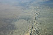
San Andreas Fault
The San Andreas Fault is a continental strike-slip fault that runs a length of roughly through California in the United States. The fault's motion is right-lateral strike-slip...
, which cuts across California
California
California is a state located on the West Coast of the United States. It is by far the most populous U.S. state, and the third-largest by land area...
and forms the tectonic boundary between the Pacific
Pacific Plate
The Pacific Plate is an oceanic tectonic plate that lies beneath the Pacific Ocean. At 103 million square kilometres, it is the largest tectonic plate....
and the North American
North American Plate
The North American Plate is a tectonic plate covering most of North America, Greenland, Cuba, Bahamas, and parts of Siberia, Japan and Iceland. It extends eastward to the Mid-Atlantic Ridge and westward to the Chersky Range in eastern Siberia. The plate includes both continental and oceanic crust...
Plate. There are many thousands of small earthquakes per year, most of them are so small that they are not felt. California's complex and interesting landscape can be attributed to the network of faulting that runs underneath the state. The earliest reported earthquake in California was felt in 1769 by the Portola expedition
Portola expedition
250px|right|Point of San Francisco Bay DiscoveryThe Portolá Expedition was led by Gaspar de Portolá from July 14, 1769 to January 24, 1770. It was the first recorded Spanish land entry and exploration of present day California, United States...
about 30 miles southeast of Los Angeles
Los Ángeles
Los Ángeles is the capital of the province of Biobío, in the commune of the same name, in Region VIII , in the center-south of Chile. It is located between the Laja and Biobío rivers. The population is 123,445 inhabitants...
, probably near the San Andreas Fault.
History
California has hundreds of active faults located throughout the state that are capable of producing large earthquakes. The most active fault is the San Jacinto Fault in Southern California, which has produced large events on a regular basis throughout recent history. The Mendocino Triple JunctionMendocino Triple Junction
The Mendocino Triple Junction is a geologic triple junction where the San Andreas Fault meets the Mendocino Fault and the Cascadia subduction zone, separating three tectonic plates: the Pacific Plate, the North American Plate and the Gorda Plate...
located offshore of Northern California is also very active, producing several earthquakes above magnitude 7 throughout history. Northern California is also subject to megathrust earthquakes on the Cascadia subduction zone
Cascadia subduction zone
The Cascadia subduction zone is a subduction zone, a type of convergent plate boundary that stretches from northern Vancouver Island to northern California. It is a very long sloping fault that separates the Juan de Fuca and North America plates.New ocean floor is being created offshore of...
(extending north from Mendocino), such as the 1700 Cascadia earthquake, magnitude of approximately 9. The town of Parkfield
Parkfield, California
Parkfield is an unincorporated community in Monterey County, California. It is located on Little Cholame Creek east of Bradley, at an elevation of 1529 feet...
in central California is located on a section of the San Andreas Fault that produces an earthquake of about magnitude 6 every 20–30 years on average in 1857, 1881, 1901, 1922, 1934, 1966 and 2004.
The largest recorded earthquake in California was the 1857 Fort Tejon earthquake, with an estimated magnitude of 8.0. This earthquake ruptured the San Andreas Fault from Parkfield to Wrightwood, a distance of 225 miles (350 km). The most destructive earthquake to date was the 7.9 magnitude 1906 San Francisco earthquake
1906 San Francisco earthquake
The San Francisco earthquake of 1906 was a major earthquake that struck San Francisco, California, and the coast of Northern California at 5:12 a.m. on Wednesday, April 18, 1906. The most widely accepted estimate for the magnitude of the earthquake is a moment magnitude of 7.9; however, other...
, in which over 3000 people perished in the earthquake and the fires that followed. The 1906 quake ruptured the northern segment of the San Andreas Fault for 296 miles (477 km), from San Juan Bautista
San Juan Bautista, California
San Juan Bautista is a city in San Benito County, California, United States. The population was 1,862 at the 2010 census, up from 1,549 at the 2000 census. The city of San Juan Bautista was named after Mission San Juan Bautista...
to near Cape Mendocino
Cape Mendocino
Cape Mendocino located on the Lost Coast entirely within Humboldt County, California, USA, is the westernmost point on the coast of California. It has been a landmark since the 16th century when the Manila Galleons would reach the coast here following the prevailing westerlies all the way across...
in the north. More recently, the 1989 Loma Prieta earthquake, which affected the San Francisco bay area
San Francisco Bay Area
The San Francisco Bay Area, commonly known as the Bay Area, is a populated region that surrounds the San Francisco and San Pablo estuaries in Northern California. The region encompasses metropolitan areas of San Francisco, Oakland, and San Jose, along with smaller urban and rural areas...
, and the 1994 Northridge earthquake which hit the Greater Los Angeles area, caused widespread damage and deaths in their respective regions.
List of earthquakes in California
Note: May include significant earthquakes with the epicenter offshore, in neighboring U.S. state, or Baja CaliforniaBaja California
Baja California officially Estado Libre y Soberano de Baja California is one of the 31 states which, with the Federal District, comprise the 32 Federal Entities of Mexico. It is both the northernmost and westernmost state of Mexico. Before becoming a state in 1953, the area was known as the North...
, Mexico
Mexico
The United Mexican States , commonly known as Mexico , is a federal constitutional republic in North America. It is bordered on the north by the United States; on the south and west by the Pacific Ocean; on the southeast by Guatemala, Belize, and the Caribbean Sea; and on the east by the Gulf of...
. Stated fatalities are not limited to California.
| Year | Date | Time (UTC) | Time (Local) | Area | Magnitude | Fatalities | Epicenter | | Title | | Source |
|---|---|---|---|---|---|---|---|---|---|
| 1680 | unknown | unknown | unknown | Palm Springs-Indio to San Bernardino | 7.7 or 7.8 | unknown | Along the Southern San Andreas Fault | This earthquake affected the Coachella Valley, and San Bernardino sections of the San Andreas. It's unknown if it affected the Mojave section to Wrightwood. | |
| 1769 | July 28 | 21:00 | 13:00 | Santa Ana River Santa Ana River The Santa Ana River is the largest river of Southern California in the United States. Its drainage basin spans four counties. It rises in the San Bernardino Mountains and flows past the cities of San Bernardino and Riverside, before cutting through the northern tip of the Santa Ana Mountains and... |
6.5-7.0 | unknown | Los Angeles basin felt widely | Portola Expedition earthquake | |
| 1800 | November 22 | 21:30 | 13:30 | San Diego | 6.5 | unknown | Most likely to have occurred on the Rose Canyon Fault - Downtown San Diego | San Diego earthquake | |
| 1812 | December 8 | 15:00 | 07:00 | Wrightwood | 6.9-7.5 | 40 | 1812 Wrightwood earthquake | ||
| 1812 | December 21 | 19:00 | 11:00 | Santa Barbara Santa Barbara, California Santa Barbara is the county seat of Santa Barbara County, California, United States. Situated on an east-west trending section of coastline, the longest such section on the West Coast of the United States, the city lies between the steeply-rising Santa Ynez Mountains and the Pacific Ocean... |
7.1 | 1? | 1812 Santa Barbara earthquake | ||
| 1838 | June | San Francisco Peninsula San Francisco Peninsula The San Francisco Peninsula is a peninsula in the San Francisco Bay Area that separates the San Francisco Bay from the Pacific Ocean. On its northern tip is the City and County of San Francisco. Its southern base is in Santa Clara County, including the cities of Palo Alto, Los Altos, and Mountain... |
6.8-7.4 | 1838 San Francisco earthquake | |||||
| 1857 | January 9 | 16:24 | 08:24 | Parkfield-Wrightwood | 7.9 | 2 | 35.43°N 120.19°W | 1857 Fort Tejon earthquake | |
| 1865 | October 8 | 20:46 | 12:46 | Santa Cruz Mountains Santa Cruz Mountains The Santa Cruz Mountains, part of the Pacific Coast Ranges, are a mountain range in central California, United States. They form a ridge along the San Francisco Peninsula, south of San Francisco, separating the Pacific Ocean from San Francisco Bay and the Santa Clara Valley, and continuing south,... |
6.5 | 1865 San Francisco earthquake | |||
| 1868 | October 21 | 15:53 | 07:53 | Hayward Hayward, California Hayward is a city located in the East Bay in Alameda County, California. With a population of 144,186, Hayward is the sixth largest city in the San Francisco Bay Area and the third largest in Alameda County. Hayward was ranked as the 37th most populous municipality in California. It is included in... |
6.8-7.0 | 30 | 37.70°N 122.10°W | 1868 Hayward earthquake 1868 Hayward earthquake The 1868 Hayward earthquake was the last large earthquake to occur on the Hayward Fault Zone in the San Francisco Bay Area, California, United States. It caused significant damage throughout the region, and was known as the "Great San Francisco Earthquake" prior to the 1906 San Francisco earthquake... |
|
| 1872 | March 26 | 10:30 | 02:30 | Owens Valley Owens Valley Owens Valley is the arid valley of the Owens River in eastern California in the United States, to the east of the Sierra Nevada and west of the White Mountains and Inyo Mountains on the west edge of the Great Basin section... |
7.4-7.8 | 27 | 36.60°N 118.06°W | 1872 Lone Pine earthquake 1872 Lone Pine earthquake The Great Lone Pine earthquake was one of the largest earthquakes to hit California in recorded history. The quake struck on March 26, 1872 and its epicenter was near Lone Pine, California in Owens Valley... |
|
| 1892 | February 23 | 7:20 | 23:20 | Imperial Valley | 7.2-7.8 | 32.50°N 115.67°W | 1892 Imperial Valley earthquake | ||
| 1892 | April 19 | 10:50 | 02:50 | Vacaville | 6.4 | 1 | 38.24°N 122.00°W | 1892 Vacaville-Winters earthquakes | |
| 1892 | April 21 | 17:43 | 09:43 | Winters Winters, California Winters is a city in Yolo County, California. The population was 6,624 as of the 2010 census. It is part of the Sacramento–Arden-Arcade–Roseville Metropolitan Statistical Area. The city is near Lake Berryessa. It is noted as the one-time residence of cartoonist R... |
6.4 | 38.30°N 121.54°W | 1892 Vacaville-Winters earthquakes | ||
| 1899 | December 25 | 12:25 | 04:25 | San Jacinto San Jacinto, California San Jacinto is a city in Riverside County, California, U.S.A. It was named after Saint Hyacinth and is located at the north end of the San Jacinto Valley, with Hemet to its south. The mountains associated with the valley are the San Jacinto Mountains. The population was 44,199 at the 2010... |
6.5-6.7 | 6 | 33.66°N 116.83°W | 1899 San Jacinto earthquake | |
| 1906 | April 18 | 13:12 | 05:12 | San Francisco | 7.8 | 3000+ | 37.70°N 122.50°W | 1906 San Francisco earthquake 1906 San Francisco earthquake The San Francisco earthquake of 1906 was a major earthquake that struck San Francisco, California, and the coast of Northern California at 5:12 a.m. on Wednesday, April 18, 1906. The most widely accepted estimate for the magnitude of the earthquake is a moment magnitude of 7.9; however, other... |
|
| 1915 | June 22 (Local) June 23 (UTC) |
03:59 | 19:59 | Imperial Valley Imperial Valley The Imperial Valley is an agricultural area of Southern California's Imperial County. It is located in southeastern Southern California, centered around the city of El Centro. Locally, the terms "Imperial Valley" and "Imperial County" are used synonymously. The Valley is bordered between the... |
6.3 | 6 | 32.81°N 115.50°W | 1915 Imperial Valley earthquakes | |
| 1918 | April 21 | 22:32 | 14:32 | San Jacinto San Jacinto, California San Jacinto is a city in Riverside County, California, U.S.A. It was named after Saint Hyacinth and is located at the north end of the San Jacinto Valley, with Hemet to its south. The mountains associated with the valley are the San Jacinto Mountains. The population was 44,199 at the 2010... |
6.8 | 1 | 33.75°N 116.88°W | 1918 San Jacinto earthquake | |
| 1923 | January 22 | 09:04 | 01:04 | offshore Cape Mendocino Cape Mendocino Cape Mendocino located on the Lost Coast entirely within Humboldt County, California, USA, is the westernmost point on the coast of California. It has been a landmark since the 16th century when the Manila Galleons would reach the coast here following the prevailing westerlies all the way across... |
7.2 | 40.50°N 124.50°W | 1923 Cape Mendocino earthquake | ||
| 1925 | June 29 | 14:44 | 06:44 | Santa Barbara Santa Barbara, California Santa Barbara is the county seat of Santa Barbara County, California, United States. Situated on an east-west trending section of coastline, the longest such section on the West Coast of the United States, the city lies between the steeply-rising Santa Ynez Mountains and the Pacific Ocean... |
6.3-6.8 | 13 | 34.33°N 119.80°W | 1925 Santa Barbara earthquake | |
| 1932 | June 6 | 08:44 | 01:44 | offshore Eureka Eureka, California Eureka is the principal city and the county seat of Humboldt County, California, United States. Its population was 27,191 at the 2010 census, up from 26,128 at the 2000 census.... |
6.4 | 1 | 40.75°N 124.50°W | 1932 Eureka earthquake | |
| 1933 | March 10 (Local) March 11 (UTC) |
01:54 | 17:54 | Long Beach Long Beach, California Long Beach is a city situated in Los Angeles County in Southern California, on the Pacific coast of the United States. The city is the 36th-largest city in the nation and the seventh-largest in California. As of 2010, its population was 462,257... |
6.4 | 115 | 33.63°N 117.99°W | 1933 Long Beach earthquake 1933 Long Beach earthquake The Long Beach earthquake of 1933 took place on March 10, 1933 at 17:55 PST , with a magnitude of 6.4, causing widespread damage to buildings throughout Southern California. The epicenter was offshore, southeast of Long Beach on the Newport-Inglewood Fault. An estimated fifty million dollars worth... |
|
| 1940 | May 18 (Local) May 19 (UTC) |
04:37 | 20:37 | Imperial Valley Imperial Valley The Imperial Valley is an agricultural area of Southern California's Imperial County. It is located in southeastern Southern California, centered around the city of El Centro. Locally, the terms "Imperial Valley" and "Imperial County" are used synonymously. The Valley is bordered between the... |
6.9 | 9 | 32.84°N 115.38°W | 1940 Imperial Valley earthquake 1940 El Centro earthquake The 1940 El Centro earthquake struck on 18 May 1940, due to a rupture of the Imperial Fault, and was the strongest recorded earthquake to hit the Imperial Valley... |
|
| 1942 | October 21 | 16:22 | 09:22 | Fish Creek Mountains Fish Creek Mountains (California) The Fish Creek Mountains are a mountain range in Imperial County, California.... |
6.6 | 32.97°N 116.00°W | 1942 Fish Creek Mountains earthquake | ||
| 1947 | April 10 | 15:58 | 07:58 | near Barstow Barstow, California Barstow is a city in San Bernardino County, California, United States. The population was 22,639 at the 2010 census, up from 21,119 at the 2000 census. Barstow is located north of San Bernardino.... |
6.5 | 34.98°N 116.55°W | 1947 Manix earthquake | ||
| 1948 | December 4 | 23:43 | 15:43 | near Desert Hot Springs Desert Hot Springs, California Desert Hot Springs, also known as DHS, is a city in Riverside County, California, United States. The city is located within the Coachella Valley geographic region, sometimes referred to as the Desert Empire. The population was 25,938 at the 2010 census, up from 16,582 at the 2000 United States... |
6.0 | 33.93°N 116.38°W | 1948 Desert Hot Springs earthquake | ||
| 1952 | July 21 | 11:52 | 04:52 | Kern County | 7.3-7.5 | 12 | 35.00°N 119.02°W | 1952 Kern County earthquake 1952 Kern County earthquake The 1952 Kern County earthquake occurred on July 21, 1952, in Kern County, California, with a magnitude of 7.5Mw. It was the largest earthquake to strike Southern California since the Fort Tejon earthquake of 1857 and the 1872 Lone Pine earthquake, causing immense and widespread damage. The main... |
|
| 1954 | March 19 | 09:54 | 01:54 | west of Salton City Salton City, California Salton City is a census-designated place in Imperial County, California. The population was 3,763 at the 2010 census, up from 978 at the 2000 census. It is the largest Imperial County development on the Salton coast. It is part of the El Centro, California Metropolitan Statistical Area... |
6.4 | 34.30°N 116.08°W | 1954 Arroyo Salada earthquake | ||
| 1954 | December 21 | 19:56 | 11:56 | east of Arcata Arcata, California -Demographics:-2010 Census data:The 2010 United States Census reported that Arcata had a population of 17,231. The population density was 1,567.4 people per square mile... |
6.5 | 1 | 40.78°N 123.87°W | 1954 Eureka earthquake | |
| 1957 | March 22 | 19:44 | 11:44 | Daly City | 5.3 | 1 | 37.67°N 122.48°W | 1957 Daly City earthquake | |
| 1968 | April 8 (Local) April 9 (UTC) |
02:29 | 18:29 | Ocotillo Wells | 6.5 | 33.17°N 116.10°W | 1968 Borrego Mountain earthquake | ||
| 1971 | February 9 | 14:01 | 06:01 | San Fernando San Fernando, California San Fernando is a city located in the San Fernando Valley, in northwestern region of Los Angeles, California, United States. The population was 23,645 at the 2010 census, up from 23,564 at the 2000 census.-History:... |
6.6 | 65 | 34.24°N 118.24°W | 1971 San Fernando earthquake | |
| 1979 | October 15 | 23:16 | 16:16 | Imperial Valley Imperial Valley The Imperial Valley is an agricultural area of Southern California's Imperial County. It is located in southeastern Southern California, centered around the city of El Centro. Locally, the terms "Imperial Valley" and "Imperial County" are used synonymously. The Valley is bordered between the... |
6.5 | 32.66°N 115.36°W | 1979 Imperial Valley earthquake | ||
| 1980 | January 24 | 19:00 | 11:00 | Livermore Livermore, California Livermore is a city in Alameda County. The population as of 2010 was 80,968. Livermore is located on the eastern edge of California's San Francisco Bay Area.... |
5.8 | 37.84°N 121.80°W | 1980 Livermore earthquake | ||
| 1980 | November 8 | 10:27 | 02:27 | offshore Humboldt County Humboldt County, California Humboldt County is a county in the U.S. state of California, located on the far North Coast 200 miles north of San Francisco. According to 2010 Census Data, the county’s population was 134,623... |
7.2 | 41.08°N 124.62°W | 1980 Humboldt County earthquake | ||
| 1983 | May 2 | 22:42 | 15:42 | Coalinga | 6.5 | 36.22°N 120.32°W | 1983 Coalinga earthquake 1983 Coalinga earthquake The 1983 Coalinga earthquake occurred on May 2, 1983 at exactly 23:42 UTC in Coalinga, California. The earthquake recorded 6.5 on the Richter scale. The earthquake was caused by an unknown fault buried under the surface.... |
||
| 1984 | April 24 | 21:15 | 13:15 | Morgan Hill | 6.2 | 37.31°N 121.68°W | 1984 Morgan Hill earthquake 1984 Morgan Hill earthquake The 1984 Morgan Hill Earthquake was a magnitude 6.2 earthquake that occurred on April 24, 1984 at 1:15 PM local time, in the south San Francisco Bay Area, California... |
||
| 1986 | July 8 | 08:20 | 01:20 | North Palm Springs Desert Hot Springs, California Desert Hot Springs, also known as DHS, is a city in Riverside County, California, United States. The city is located within the Coachella Valley geographic region, sometimes referred to as the Desert Empire. The population was 25,938 at the 2010 census, up from 16,582 at the 2000 United States... |
6.0 | 34.00°N 116.60°W | 1986 North Palm Springs earthquake | ||
| 1986 | July 13 | 13:47 | 06:47 | Oceanside Oceanside, California -2010:The 2010 United States Census reported that Oceanside had a population of 167,086. The population density was 3,961.8 people per square mile... |
5.3 | 1 | 32.58°N 117.51°W | 1986 Oceanside earthquake | |
| 1986 | July 21 | 13:42 | 06:42 | Chalfant Valley | 6.2 | 37.53°N 118.44°W | 1986 Chalfant Valley earthquake 1986 Chalfant Valley earthquake The 1986 Chalfant Valley earthquake struck the southern Mono County and surrounding incorporated and unincorporated of the Bishop - Chalfant Valley, California areas at 6:42 p.m. . The magnitude 6.2 earthquake was felt as far distant as Salt Lake City, Utah. The earthquake was felt in some counties... |
||
| 1987 | October 1 | 14:42 | 07:42 | Whittier Narrows Whittier Narrows The Whittier Narrows is located at the southern boundary of the San Gabriel Valley, in Los Angeles County, California. It is a gap in the Puente Hills where the Rio Hondo and the San Gabriel River diverge.... |
5.9 | 8 | 34.06°N 118.08°W | 1987 Whittier Narrows earthquake | |
| 1987 | November 23 (Local) November 24 (UTC) |
01:54 | 17:54 | Elmore Desert Ranch | 6.2 | 33.09°N 115.79°W | 1987 Elmore Ranch earthquake (foreshock of the Superstition Hills earthquake about 12 hours later) | ||
| 1987 | November 24 | 14:15 | 06:15 | Superstition Hills Superstition Hills The Superstition Hills are a low mountain range in the Colorado Desert, in the Lower Colorado River Valley of western Imperial County, California.... |
6.6 | 2 | 33.01°N 115.85°W | 1987 Superstition Hills earthquake | |
| 1989 | October 17 (Local) October 18 (UTC) |
00:04 | 17:04 | Santa Cruz Mountains Santa Cruz Mountains The Santa Cruz Mountains, part of the Pacific Coast Ranges, are a mountain range in central California, United States. They form a ridge along the San Francisco Peninsula, south of San Francisco, separating the Pacific Ocean from San Francisco Bay and the Santa Clara Valley, and continuing south,... |
6.9 | 63 | 37.04°N 121.88°W | 1989 Loma Prieta earthquake | |
| 1991 | June 28 | 14:43 | 07:43 | Sierra Madre Sierra Madre, California The city of Sierra Madre is a municipality in Los Angeles County, California whose population was 10,917 at the 2010 census, up from 10,580 at the time of the 2000 census. The city is located in the Foothills of the San Gabriel Mountains below the southern edge of the Angeles National Forest. ... |
5.6 | 2 | 34.26°N 118.00°W | 1991 Sierra Madre earthquake | |
| 1992 | April 22 (Local) April 23 (UTC) |
04:50 | 21:50 | Joshua Tree Joshua Tree National Park Joshua Tree National Park is located in southeastern California. Declared a U.S. National Park in 1994 when the U.S. Congress passed the California Desert Protection Act , it had previously been a U.S. National Monument since 1936. It is named for the Joshua tree forests native to the park... |
6.1 | 33.96°N 116.32°W | 1992 Joshua Tree earthquake | ||
| 1992 | April 25 | 18:06 | 11:06 | Cape Mendocino Cape Mendocino Cape Mendocino located on the Lost Coast entirely within Humboldt County, California, USA, is the westernmost point on the coast of California. It has been a landmark since the 16th century when the Manila Galleons would reach the coast here following the prevailing westerlies all the way across... |
7.2 | 40.33°N 124.23°W | 1992 Cape Mendocino earthquake 1992 Cape Mendocino earthquakes The 1992 Cape Mendocino earthquakes were a series of three earthquakes that occurred off the coast of Cape Mendocino, California on April 25 and 26, 1992. They consisted of a 7.2-magnitude main shock and two strong aftershocks that spawned a series of smaller aftershocks that ranged in magnitude... |
||
| 1992 | June 28 | 11:57 | 04:57 | Landers | 7.3 | 3 | 34.13°N 116.26°W | 1992 Landers earthquake 1992 Landers earthquake The 1992 Landers earthquake was a magnitude 7.3 earthquake that occurred on June 28, 1992 with an epicenter near the town of Landers, California... |
|
| 1992 | June 28 | 15:05 | 08:05 | Big Bear Big Bear Lake, California Big Bear Lake is a city in San Bernardino County, California along the south shore of Big Bear Lake, located northeast of the city of San Bernardino. The population was 5,019 at the 2010 census, down from 5,438 at the 2000 census... |
6.5 | 34.20°N 116.82°W | 1992 Big Bear earthquake 1992 Big Bear earthquake The 1992 Big Bear earthquake was an earthquake that occurred at 08:05 PDT local time on 28 June 1992 in Big Bear Lake, California, with a magnitude of 6.5. This earthquake occurred three hours after the 7.3 magnitude Landers earthquake, which was centered to the east... |
||
| 1994 | January 17 | 12:30 | 04:30 | Northridge Northridge, Los Angeles, California Northridge is a community located in the San Fernando Valley region of the City of Los Angeles, California, United States.The 1994 Northridge earthquake is named for the place based on early estimates of the location of the quake's epicenter; however, further refinements showed it to be technically... |
6.7 | 60 | 34.12°N 118.32°W | 1994 Northridge earthquake | |
| 1999 | October 16 | 09:46 | 02:46 | Hector Mine | 7.1 | 34.59°N 116.27°W | 1999 Hector Mine earthquake | ||
| 2003 | December 22 | 19:15 | 11:15 | San Simeon | 6.5 | 2 | 35.71°N 121.10°W | 2003 San Simeon earthquake | |
| 2004 | September 28 | 17:15 | 10:15 | Parkfield | 6.0 | 35.81°N 120.37°W | 2004 Parkfield earthquake Parkfield earthquake Parkfield earthquake is a name given to various large earthquakes that occurred in the vicinity of the town of Parkfield, California, United States... |
||
| 2005 | June 12 | 15:41 | 08:41 | Anza Anza, California Anza is a census-designated place located in southern Riverside County, California, in the Anza Valley, a semi-arid region at a mean elevation of above sea level. It is located south of Idyllwild, and approximately southwest of Palm Springs, southeast of Los Angeles, California and... |
5.2 | 33.53°N 116.58°W | 2005 Anza earthquake | ||
| 2005 | June 16 | 20:53 | 13:53 | Yucaipa Yucaipa, California Yucaipa is a city located east of San Bernardino, in San Bernardino County, California, United States. The population was 51,367 at the 2010 census, up from 41,207 at the 2000 census... |
4.9 | 34.06°N 117.01°W | 2005 Yucaipa earthquake | ||
| 2007 | October 30 (Local) October 31 (UTC) |
03:04 | 20:04 | Alum Rock Alum Rock, California Alum Rock is a census-designated place in Santa Clara County, California, United States and a community of San Jose. The CDP, which excludes all annexed areas, had a population of 15,536 at the 2010 census. Alum Rock was named after a rock formerly thought to be composed of alum in nearby Alum... |
5.6 | 37.43°N 121.78°W | 2007 Alum Rock earthquake 2007 Alum Rock earthquake The 2007 Alum Rock earthquake occurred on October 30, 2007 at approximately 8:04 p.m. PDT in Alum Rock Park in San Jose, California... |
||
| 2008 | July 29 | 18:42 | 11:42 | Chino Hills Chino Hills, California Chino Hills is a Los Angeles suburb located in the southwestern corner of San Bernardino County, California, United States. The city borders Los Angeles County on its northwest side, Orange County to its south, and Riverside County to its southeast... |
5.5 | 33.95°N 117.76°W | 2008 Chino Hills earthquake 2008 Chino Hills earthquake The 2008 Chino Hills earthquake occurred at 11:42:15 a.m. PDT on July 29, 2008, in Southern California. The epicenter of the magnitude 5.5 earthquake was in Chino Hills, approximately east-southeast of downtown Los Angeles.... |
||
| 2009 | May 17 (Local) May 18 (UTC) |
03:39 | 20:39 | Inglewood Inglewood, California Inglewood is a city in southwestern Los Angeles County, California, southwest of downtown Los Angeles. It was incorporated on February 14, 1908. Its population stood at 109,673 as of the 2010 Census... |
4.7 | 33.94°N 118.35°W | 2009 Inglewood earthquake | ||
| 2010 | January 9 (Local) January 10 (UTC) |
00:27 | 16:27 | offshore Humboldt County Humboldt County, California Humboldt County is a county in the U.S. state of California, located on the far North Coast 200 miles north of San Francisco. According to 2010 Census Data, the county’s population was 134,623... |
6.5 | 40.65°N 124.76°W | 2010 Eureka earthquake | ||
| 2010 | February 4 | 20:20 | 12:20 | offshore Humboldt County Humboldt County, California Humboldt County is a county in the U.S. state of California, located on the far North Coast 200 miles north of San Francisco. According to 2010 Census Data, the county’s population was 134,623... |
5.9 | 40.42°N 124.92°W | |||
| 2010 | March 16 | 11:04 | 4:04 | Pico Rivera Pico Rivera, California Pico Rivera is a city located in southeastern Los Angeles County, California, United States. The city is situated approximately 11 miles southeast of downtown Los Angeles, on the eastern edge of the Los Angeles basin, and on the southern edge of the area known as the San Gabriel Valley... |
4.4 | 33.992°N 118.082°W | 2010 Pico Rivera earthquake | ||
| 2010 | April 4 | 22:40 | 15:40 | northern Baja California Guadalupe Victoria, Baja California Guadalupe Victoria, also known as the 43, is a small city in the state of Baja California in northern Mexico. Its population at the 2010 census was 17,119 inhabitants... |
7.2 | 3 | 32.128°N 115.303°W | 2010 El Mayor-Cucapah earthquake 2010 Baja California earthquake The 2010 Baja California earthquake was an earthquake of 7.2 magnitude on the moment magnitude scale. It started south of Guadalupe Victoria, Baja California, Mexico, at a depth of . It occurred at 3:40:41 p.m... |
|
| 2010 | June 14 (local) June 15 (UTC) |
04:26 | 21:26 | Ocotillo Ocotillo, California Ocotillo is a census-designated place in Imperial County, California. Ocotillo is located west of El Centro, The population was 266 at the 2010 census, down from 296 at the 2000 census... |
5.7 | 32.698°N 115.924°W | 2010 El Mayor-Cucapah aftershock | ||
| 2010 | July 7 | 23:53 | 16:53 | Borrego Springs Borrego Springs, California Borrego Springs is a census-designated place in San Diego County, California. The population was 3,429 at the 2010 census, up from 2,535 at the 2000 census. Many residents are seasonal while others remain year round... |
5.4 | 33.417°N 116.483°W | 2010 Borrego Springs earthquake | ||
| 2011 | January 7 | 23:10 | 16:10 | San Jose California | 4.1 | 37.287°N 121.658°W | 2011 Calaveras earthquake | ||
| 2011 | January 12 | 23:51 | 08:51 | San Juan Bautista | 4.5 | 36.77°N 121.499°W | 2011 Cox Sleeper earthquake | ||
Preparedness
There are many ways to protect and prepare possible sites of earthquakes from severe damage, through the following processes: Earthquake engineeringEarthquake engineering
Earthquake engineering is the scientific field concerned with protecting society, the natural and the man-made environment from earthquakes by limiting the seismic risk to socio-economically acceptable levels...
, Earthquake preparedness, Seismic retrofit
Seismic retrofit
Seismic retrofitting is the modification of existing structures to make them more resistant to seismic activity, ground motion, or soil failure due to earthquakes. With better understanding of seismic demand on structures and with our recent experiences with large earthquakes near urban centers,...
(including special fasteners, materials, and techniques), Seismic hazard
Seismic hazard
Seismic hazard refers to the study of expected earthquake ground motions at the earth's surface, and its likely effects on existing natural conditions and man-made structures for public safety considerations; the results of such studies are published as seismic hazard maps, which identify the...
, Mitigation of seismic motion
Mitigation of seismic motion
Mitigation of seismic motion is an important factor in earthquake engineering and construction in earthquake-prone areas. The destabilizing action of an earthquake on constructions may be direct or indirect .Knowledge of local amplification of the seismic motion from...
, and Earthquake prediction
Earthquake prediction
An earthquake prediction is a prediction that an earthquake of a specific magnitude will occur in a particular place at a particular time . Despite considerable research efforts by seismologists, scientifically reproducible predictions cannot yet be made to a specific day or month...
.
The United States Geological Survey
United States Geological Survey
The United States Geological Survey is a scientific agency of the United States government. The scientists of the USGS study the landscape of the United States, its natural resources, and the natural hazards that threaten it. The organization has four major science disciplines, concerning biology,...
(USGS) and California Institute of Technology
California Institute of Technology
The California Institute of Technology is a private research university located in Pasadena, California, United States. Caltech has six academic divisions with strong emphases on science and engineering...
(Caltech) provide public education to California. They hope to provide "public education about seismic hazards and methods of reducing or preventing seismic disaster damage." The California Earthquake Authority outlined the risks earthquakes pose to California and measures households can take to "Quake Safe" their house. Putting Down Roots in Earthquake Country and Dare To Prepare are some of the Earthquake Readiness Campaigns.
"Putting Down Roots in Earthquake Country" is a popular 32-page earthquake science and preparedness handbook was first published in 1995 by the SCEC.
External links
- U.S. Geological Survey, Menlo Park Northern California - USGS
- University of California, Berkeley Northern California - UCB
- U.S. Geological Survey, Pasadena Southern California - USGS
- California Institute of Technology Southern California - Caltech
- University of California, San Diego Southern California - UCSD
- Southern California Earthquake Data Center
- The Southern California Earthquake Center (SCEC)
- Putting Down Roots in Earthquake Country An Earthquake Science and Preparedness Handbook produced by SCEC
- Recent earthquakes in California and Nevada
- UCSD Broadband Seismic Data Collection Center - small localized broadband seismic network monitoring the San Jacinto and San Andreas fault zones, located in Southern California