
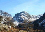
Eagle Crag
Encyclopedia
Fell
“Fell” is a word used to refer to mountains, or certain types of mountainous landscape, in Scandinavia, the Isle of Man, and parts of northern England.- Etymology :...
in the Lake District
Lake District
The Lake District, also commonly known as The Lakes or Lakeland, is a mountainous region in North West England. A popular holiday destination, it is famous not only for its lakes and its mountains but also for its associations with the early 19th century poetry and writings of William Wordsworth...
in Cumbria
Cumbria
Cumbria , is a non-metropolitan county in North West England. The county and Cumbria County Council, its local authority, came into existence in 1974 after the passage of the Local Government Act 1972. Cumbria's largest settlement and county town is Carlisle. It consists of six districts, and in...
, England
England
England is a country that is part of the United Kingdom. It shares land borders with Scotland to the north and Wales to the west; the Irish Sea is to the north west, the Celtic Sea to the south west, with the North Sea to the east and the English Channel to the south separating it from continental...
, it is situated near the village of Stonethwaite
Stonethwaite
Stonethwaite is a small village in the Lake District in the English county of Cumbria. It is situated in the valley of the Stonethwaite Beck, a side valley of Borrowdale, and within the Lake District National Park...
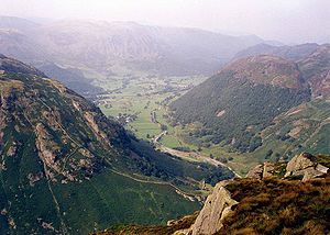
where the valleys of Langstrath and Greenup join. Impressive walls of crag look down upon Stonethwaite, making Eagle Crag the most arresting sight from that settlement. It can be climbed direct by the average walker, picking a route between the rock faces.
Topography
The fell has not been given an official height by the Ordnance SurveyOrdnance Survey
Ordnance Survey , an executive agency and non-ministerial government department of the Government of the United Kingdom, is the national mapping agency for Great Britain, producing maps of Great Britain , and one of the world's largest producers of maps.The name reflects its creation together with...
and is given various heights by several other sources ranging between 520 and 525 metres. Bill Birkett
Bill Birkett
Bill Birkett is one of the world's foremost mountain writers and photographers, and is a leading climber who has undertaken many expeditions around the world....
gives the fell a height of 521 metres (1,709 ft) in his Complete Lakeland Fells. Alfred Wainwright
Alfred Wainwright
Alfred Wainwright MBE was a British fellwalker, guidebook author and illustrator. His seven-volume Pictorial Guide to the Lakeland Fells, published between 1955 and 1966 and consisting entirely of reproductions of his manuscript, has become the standard reference work to 214 of the fells of the...
gave the height at 1,650 feet (503 metres) approx in his Pictorial Guides to the Lakeland Fells in 1958, in which he writes:
- “Eagle Crag is so splendidly situated, so nobly proportioned and of so arresting appearance that it is a far worthier object than the parent fell (High Raise) rising behind”.
Eagle Crag is part of the craggy termination of the northern ridge of the higher fell of High Raise
High Raise (Langdale)
High Raise is a fell in the Central Fells of the English Lake District not to be confused with another High Raise situated in the Far Eastern Fells...
and it presents a spectacular sight when viewed from the Stonethwaite valley. It is linked to Sergeant's Crag
Sergeant's Crag
Sergeant's Crag is a fell in the English Lake District. It is an intermediate height on the ridge between the Langstrath and Greenup valleys in the Central Fells.-Topography:...
which is just under a kilometre away to the south by a ridge along which runs a dry stone wall which acts as navigation guide for walkers between the two tops.
Geology
The summit area is formed of the welded rhyolitic lapilliLapilli
Lapilli is a size classification term for tephra, which is material that falls out of the air during a volcanic eruption or during some meteorite impacts. Lapilli means "little stones" in Latin. They are in some senses similar to ooids or pisoids in calcareous sediments.By definition lapilli range...
-tuff
Tuff
Tuff is a type of rock consisting of consolidated volcanic ash ejected from vents during a volcanic eruption. Tuff is sometimes called tufa, particularly when used as construction material, although tufa also refers to a quite different rock. Rock that contains greater than 50% tuff is considered...
, tuff and breccia
Breccia
Breccia is a rock composed of broken fragments of minerals or rock cemented together by a fine-grained matrix, that can be either similar to or different from the composition of the fragments....
of the Crinkle Member. Patches of rhyolite outcrop lower down the slope.
Summit and View
A small cairnCairn
Cairn is a term used mainly in the English-speaking world for a man-made pile of stones. It comes from the or . Cairns are found all over the world in uplands, on moorland, on mountaintops, near waterways and on sea cliffs, and also in barren desert and tundra areas...
marks the summit, balanced on a tilted slab of rock, with crags a few yards distant to west and north. A corner in the dry stone wall is a couple of minutes walk away southward. The view from the top of the fell is best to the north and west with Borrowdale
Borrowdale
Borrowdale is a valley and civil parish in the English Lake District in the Borough of Allerdale in Cumbria, England.Borrowdale lies within the historic county boundaries of Cumberland, and is sometimes referred to as Cumberland Borrowdale in order to distinguish it from another Borrowdale in the...
and the Langstrath valley and the fells around them being well seen.
Ascents
Eagle Crag is invariably climbed from Stonethwaite; it can be combined with the higher fells of High Raise and UllscarfUllscarf
Ullscarf is a fell in the English Lake District close to the geographical centre of the Cumbrian hills. It forms part of the watershed between the Derwentwater and Thirlmere catchments, a ridge running broadly north-south.-Topography:...
as well as the nearby Sergeant’s Crag. A direct ascent of the fell seems to be impossible when it is viewed from the Stonethwaite valley, with vertical walls of crags seemingly barring the way, however a route can be found through the crags to attain the summit directly. Descents by this route are not recommended because of the dangerous crags which cannot be seen from above. An easier ascent follows the bridleway up Greenup Gill; this well-blazed trail is part of Wainwright’s Coast to Coast Walk
Coast to Coast Walk
The Coast to Coast Walk is a 192-mile unofficial and mostly unsignposted long distance footpath in Northern England...
. The route leaves the bridleway at height of 330 metres and attains the fell by cutting back on itself and climbing steep grassy slopes to the summit.
Rock Climbing
The crags directly beneath the summit are used by rock climbersClimbing
Climbing is the activity of using one's hands and feet to ascend a steep object. It is done both for recreation and professionally, as part of activities such as maintenance of a structure, or military operations.Climbing activities include:* Bouldering: Ascending boulders or small...
with climbs graded
Grade (climbing)
In rock climbing, mountaineering and other climbing disciplines, climbers give a climbing grade to a route that concisely describes the difficulty and danger of climbing the route...
in the extreme and very severe categories.