

Döhlen Basin
Encyclopedia
Saxony
The Free State of Saxony is a landlocked state of Germany, contingent with Brandenburg, Saxony Anhalt, Thuringia, Bavaria, the Czech Republic and Poland. It is the tenth-largest German state in area, with of Germany's sixteen states....
, southwest of Dresden
Dresden
Dresden is the capital city of the Free State of Saxony in Germany. It is situated in a valley on the River Elbe, near the Czech border. The Dresden conurbation is part of the Saxon Triangle metropolitan area....
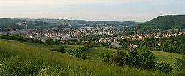
. The Döhlen Basin has a length of 22 km and a width of 6 km and lies within the district of Sächsische Schweiz-Osterzgebirge.
Description
In the centre of the basinBasin (geology)
A structural basin is a large-scale structural formation of rock strata formed by tectonic warping of previously flat lying strata. Structural basins are geological depressions, and are the inverse of domes. Some elongated structural basins are also known as synclines...
is the large county town of Freital
Freital
Freital is the biggest town in the Sächsische Schweiz-Osterzgebirge district, in the Free State of Saxony, Germany. It is situated on the small river Weißeritz, 8 km southwest of Dresden.- Geography :...
; although the basin is named after Döhlen, one of the villages in the borough. The highest point in the area is the Lerchenberg near Possendorf at 425 m above NN; the lowest point is in the river valley of the Weißeritz
Weißeritz
The Weißeritz is a river in Saxony. The 12 km short left tributary of the Elbe runs through Freital and Dresden. Its name is derived from west Slavic bystrica . The official name of the river used in documents and hydrographic maps is Vereinigte Weißeritz...
at 160 m above NN. The Karsdorf fault
Karsdorf Fault
The Karsdorf Fault is a striking tectonic fracture line, which is part of the Central Saxon Fault, and is located in the eastern Ore Mountains and the Elbe Valley Slate Mountains...
forms the geological boundary with the Eastern Ore Mountains
Eastern Ore Mountains
The Eastern Ore Mountains form a natural region that covers the eastern part of the Saxon Ore Mountains. It is part of the major landscape unit, the Saxon Highlands and Uplands...
to the south.
Sources
- Sächsisches Landesamt für Umwelt und Geologie / Sächsisches Oberbergamt [Hrsg.]: Das Döhlener Becken bei Dresden. Geologie und Bergbau. Dresden 2007. ISBN 3-9811421-0-1. digitalised (pdf file, 44 MB)