
Dunlap, Tennessee
Encyclopedia
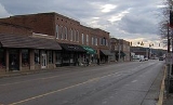
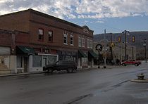
Dunlap is a city in Sequatchie County, Tennessee
, United States
. The population was 4,173 at the 2000 census. It is the county seat
of Sequatchie County.
Dunlap is part of the Chattanooga
, TN–GA
Metropolitan Statistical Area
.
, a long and narrow valley stretching like a 65 miles (104.6 km) gash in the Cumberland Plateau
in southeastern Tennessee and northeastern Alabama
. The plateau's western Sequatchie Valley escarpment, known locally as "Fredonia Mountain," rises over 1000 feet (304.8 m) above the valley just west of Dunlap. The Sequatchie River forms the city's southeastern boundary.
U.S. Route 127
(called "Rankin Avenue" in Dunlap), which traverses the Tennessee section of Sequatchie Valley, connects Dunlap to Crossville
and the upper plateau area to the north and Chattanooga
opposite Signal Mountain to the southeast. Tennessee State Route 111, which intersects US-127 in Dunlap, connects the city to Chattanooga to the southeast and the Eastern Highland Rim
area opposite the plateau to the northwest.
According to the United States Census Bureau
, the city has a total area of 8.6 square miles (22.3 km²), all of it land.
 As of the census
of 2000, there were 4,173 people, 1,642 households, and 1,182 families residing in the city. The population density
was 484.2 people per square mile (186.9/km²). There were 1,767 housing units at an average density of 205.0 per square mile (79.1/km²). The racial makeup of the city was 98.87% White, 0.17% African American, 0.19% Native American, 0.24% Asian, 0.10% from other races
, and 0.43% from two or more races. Hispanic or Latino of any race were 0.81% of the population.
There were 1,642 households out of which 33.5% had children under the age of 18 living with them, 53.6% were married couples
living together, 14.3% had a female householder with no husband present, and 28.0% were non-families. 25.3% of all households were made up of individuals and 10.9% had someone living alone who was 65 years of age or older. The average household size was 2.47 and the average family size was 2.90.
In the city the population was spread out with 24.7% under the age of 18, 9.6% from 18 to 24, 28.3% from 25 to 44, 22.9% from 45 to 64, and 14.5% who were 65 years of age or older. The median age was 36 years. For every 100 females there were 94.8 males. For every 100 females age 18 and over, there were 90.5 males.
The median income for a household in the city was $30,647, and the median income for a family was $34,542. Males had a median income of $26,118 versus $19,952 for females. The per capita income
for the city was $17,567. About 18.1% of families and 20.1% of the population were below the poverty line, including 25.5% of those under age 18 and 27.9% of those age 65 or over.
The Sequatchie County school system has three schools
 Dunlap was founded in 1858 as a county seat for Sequatchie County, which had been created the previous year. The city was named for state legislator William Dunlap, who played a prominent role in the county's creation. The city's initial 40 acre (0.1618744 km²), which were deeded to the county commissioners by Willam Rankin, were chosen due to their central location within the new county. Dunlap was incorporated as a city in 1941.
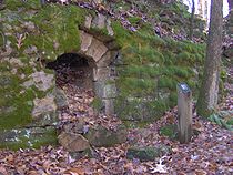
Around 1900, the Douglas Coal and Coke Company purchased 14000 acres (56.7 km²) of land in the Dunlap vicinity with plans to mine coal and convert the coal into industrial coke
. Coke, which is created by heating coal and removing the coal's volatile matter, is used primarily as a deoxidizing agent
in the production of pig iron
. To convert coal mined on nearby Fredonia Mountain into coke, Douglas built the first of 268 ovens. The company used an incline railway to move the coal from the mountain to the ovens. Although Douglas went bankrupt in 1904, the Chattanooga Iron and Coal Company purchased the ovens, and continued producing coke until 1927. In the 1980s and 1990s, the Sequatchie Valley Historical Association acquired the ruins of the coke ovens and established Dunlap Coke Ovens Park
.
festival, are held at the Dunlap Coke Ovens Park every year. Dunlap is often referred to as the "Hang Gliding Capital of the East" and is home to the East Coast Hang Gliding Championships and a hang gliding
organization known as the Tennessee Tree Toppers.
The Mount Airy Golf Course is located just north of the city at the Sequatchie-Bledsoe county line. Savage Gulf State Natural Area
is located atop the Cumberland Plateau to the west and Prentice Cooper State Forest is located atop the plateau to the east.
Tennessee
Tennessee is a U.S. state located in the Southeastern United States. It has a population of 6,346,105, making it the nation's 17th-largest state by population, and covers , making it the 36th-largest by total land area...
, United States
United States
The United States of America is a federal constitutional republic comprising fifty states and a federal district...
. The population was 4,173 at the 2000 census. It is the county seat
County seat
A county seat is an administrative center, or seat of government, for a county or civil parish. The term is primarily used in the United States....
of Sequatchie County.
Dunlap is part of the Chattanooga
Chattanooga, Tennessee
Chattanooga is the fourth-largest city in the US state of Tennessee , with a population of 169,887. It is the seat of Hamilton County...
, TN–GA
Georgia (U.S. state)
Georgia is a state located in the southeastern United States. It was established in 1732, the last of the original Thirteen Colonies. The state is named after King George II of Great Britain. Georgia was the fourth state to ratify the United States Constitution, on January 2, 1788...
Metropolitan Statistical Area
Chattanooga metropolitan area
The Chattanooga Metropolitan Statistical Area, as defined by the United States Census Bureau, is an area consisting of six counties – three in southeast Tennessee and three in northwest Georgia – anchored by the city of Chattanooga...
.
Geography
Dunlap is located at 35°22′38"N 85°23′18"W (35.377236, -85.388455). The city is located near the center of Sequatchie ValleySequatchie Valley
Sequatchie Valley is a relatively long and narrow valley in the U.S. state of Tennessee and, in some definitions, Alabama. It is generally considered to be part of the Cumberland Plateau region of the Appalachian Mountains; it was probably formed by erosion of a compression anticline, rather than...
, a long and narrow valley stretching like a 65 miles (104.6 km) gash in the Cumberland Plateau
Cumberland Plateau
The Cumberland Plateau is the southern part of the Appalachian Plateau. It includes much of eastern Kentucky and western West Virginia, part of Tennessee, and a small portion of northern Alabama and northwest Georgia . The terms "Allegheny Plateau" and the "Cumberland Plateau" both refer to the...
in southeastern Tennessee and northeastern Alabama
Alabama
Alabama is a state located in the southeastern region of the United States. It is bordered by Tennessee to the north, Georgia to the east, Florida and the Gulf of Mexico to the south, and Mississippi to the west. Alabama ranks 30th in total land area and ranks second in the size of its inland...
. The plateau's western Sequatchie Valley escarpment, known locally as "Fredonia Mountain," rises over 1000 feet (304.8 m) above the valley just west of Dunlap. The Sequatchie River forms the city's southeastern boundary.
U.S. Route 127
U.S. Route 127
U.S. Route 127 is a long north–south United States highway in the eastern half of the United States. The southern terminus of the route is at U.S. Route 27 in Chattanooga, Tennessee. The northern terminus is at Interstate 75 near Grayling, Michigan...
(called "Rankin Avenue" in Dunlap), which traverses the Tennessee section of Sequatchie Valley, connects Dunlap to Crossville
Crossville, Tennessee
Crossville is a city in and the county seat of Cumberland County, Tennessee, United States. The population was 10,795 at the 2010 Census.-Geography:Crossville is located at...
and the upper plateau area to the north and Chattanooga
Chattanooga, Tennessee
Chattanooga is the fourth-largest city in the US state of Tennessee , with a population of 169,887. It is the seat of Hamilton County...
opposite Signal Mountain to the southeast. Tennessee State Route 111, which intersects US-127 in Dunlap, connects the city to Chattanooga to the southeast and the Eastern Highland Rim
Highland Rim
The Highland Rim is a geographic term for the area in Tennessee surrounding the Central Basin. Nashville is largely surrounded by higher terrain in all directions....
area opposite the plateau to the northwest.
According to the United States Census Bureau
United States Census Bureau
The United States Census Bureau is the government agency that is responsible for the United States Census. It also gathers other national demographic and economic data...
, the city has a total area of 8.6 square miles (22.3 km²), all of it land.
Demographics
Census
A census is the procedure of systematically acquiring and recording information about the members of a given population. It is a regularly occurring and official count of a particular population. The term is used mostly in connection with national population and housing censuses; other common...
of 2000, there were 4,173 people, 1,642 households, and 1,182 families residing in the city. The population density
Population density
Population density is a measurement of population per unit area or unit volume. It is frequently applied to living organisms, and particularly to humans...
was 484.2 people per square mile (186.9/km²). There were 1,767 housing units at an average density of 205.0 per square mile (79.1/km²). The racial makeup of the city was 98.87% White, 0.17% African American, 0.19% Native American, 0.24% Asian, 0.10% from other races
Race (United States Census)
Race and ethnicity in the United States Census, as defined by the Federal Office of Management and Budget and the United States Census Bureau, are self-identification data items in which residents choose the race or races with which they most closely identify, and indicate whether or not they are...
, and 0.43% from two or more races. Hispanic or Latino of any race were 0.81% of the population.
There were 1,642 households out of which 33.5% had children under the age of 18 living with them, 53.6% were married couples
Marriage
Marriage is a social union or legal contract between people that creates kinship. It is an institution in which interpersonal relationships, usually intimate and sexual, are acknowledged in a variety of ways, depending on the culture or subculture in which it is found...
living together, 14.3% had a female householder with no husband present, and 28.0% were non-families. 25.3% of all households were made up of individuals and 10.9% had someone living alone who was 65 years of age or older. The average household size was 2.47 and the average family size was 2.90.
In the city the population was spread out with 24.7% under the age of 18, 9.6% from 18 to 24, 28.3% from 25 to 44, 22.9% from 45 to 64, and 14.5% who were 65 years of age or older. The median age was 36 years. For every 100 females there were 94.8 males. For every 100 females age 18 and over, there were 90.5 males.
The median income for a household in the city was $30,647, and the median income for a family was $34,542. Males had a median income of $26,118 versus $19,952 for females. The per capita income
Per capita income
Per capita income or income per person is a measure of mean income within an economic aggregate, such as a country or city. It is calculated by taking a measure of all sources of income in the aggregate and dividing it by the total population...
for the city was $17,567. About 18.1% of families and 20.1% of the population were below the poverty line, including 25.5% of those under age 18 and 27.9% of those age 65 or over.
Schools
Sequatchie County has a consolidated school system which is located in Dunlap. The system operates with a Superintendent and an elected School Board.The Sequatchie County school system has three schools
- Griffith Elementary School (Grades: K-4th)
- Sequatchie County Middle SchoolSequatchie County Middle SchoolSequatchie County Middle School is a 5th through 8th grade public middle school located in Dunlap, Tennessee.Students, after they pass the 8th grade, continue their education at Sequatchie County High School located next door....
(Grades: 5th-8th) - Sequatchie County High SchoolSequatchie County High SchoolSequatchie County High School is four-year public high school located in Dunlap, Tennessee.The schools colors are Purple and Gold and its mascot is an Indian.-History:The first high school in Sequatchie County was constructed in 1909....
(Grades: 9th-12th)
History
Around 1900, the Douglas Coal and Coke Company purchased 14000 acres (56.7 km²) of land in the Dunlap vicinity with plans to mine coal and convert the coal into industrial coke
Coke (fuel)
Coke is the solid carbonaceous material derived from destructive distillation of low-ash, low-sulfur bituminous coal. Cokes from coal are grey, hard, and porous. While coke can be formed naturally, the commonly used form is man-made.- History :...
. Coke, which is created by heating coal and removing the coal's volatile matter, is used primarily as a deoxidizing agent
Deoxidizer
A deoxidizer is a chemical used in a reaction or process to remove oxygen. In comparison with antioxidants, deoxidizers are not used for stabilization during storage but for oxygen removal during manufacture...
in the production of pig iron
Pig iron
Pig iron is the intermediate product of smelting iron ore with a high-carbon fuel such as coke, usually with limestone as a flux. Charcoal and anthracite have also been used as fuel...
. To convert coal mined on nearby Fredonia Mountain into coke, Douglas built the first of 268 ovens. The company used an incline railway to move the coal from the mountain to the ovens. Although Douglas went bankrupt in 1904, the Chattanooga Iron and Coal Company purchased the ovens, and continued producing coke until 1927. In the 1980s and 1990s, the Sequatchie Valley Historical Association acquired the ruins of the coke ovens and established Dunlap Coke Ovens Park
Dunlap Coke Ovens
The Dunlap Coke Ovens are the remnants of a coke production facility near Dunlap, in the U.S. state of Tennessee. Built in the early 1900s, the facility consists of five batteries of 268 beehive ovens, which operated under various companies until the early 1920s...
.
Attractions
Several annual festivals, including a BluegrassBluegrass music
Bluegrass music is a form of American roots music, and a sub-genre of country music. It has mixed roots in Scottish, English, Welsh and Irish traditional music...
festival, are held at the Dunlap Coke Ovens Park every year. Dunlap is often referred to as the "Hang Gliding Capital of the East" and is home to the East Coast Hang Gliding Championships and a hang gliding
Hang gliding
Hang gliding is an air sport in which a pilot flies a light and unmotorized foot-launchable aircraft called a hang glider ....
organization known as the Tennessee Tree Toppers.
The Mount Airy Golf Course is located just north of the city at the Sequatchie-Bledsoe county line. Savage Gulf State Natural Area
South Cumberland State Park
South Cumberland State Park is a state park in middle Tennessee on the Cumberland Plateau.The park is one of Tennessee's newer state parks. It is a collection of several areas in four counties. Distinct areas contained within the park include:...
is located atop the Cumberland Plateau to the west and Prentice Cooper State Forest is located atop the plateau to the east.