
Donald's Hill
Encyclopedia
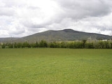
Donald's Hill is a hill
in the middle of County Londonderry
, Northern Ireland
. The summit reaches 399 metres above sea level and classifies as a Marilyn
. Located at the edge of the Sperrin Mountains
, the town of Drumsurn
sits at the foot of the hill.
The Ordnance Survey Memoirs of 1834 records an alternative name of Knocknahurkle, which is believed to be derived from Irish Cnoc na hEarcola.
An ignimbrite
formation can be found at the western edge of the plateau
with approximately 30 kilometres of outcrop between Donald's Hill and Magherafelt
.
Hill
A hill is a landform that extends above the surrounding terrain. Hills often have a distinct summit, although in areas with scarp/dip topography a hill may refer to a particular section of flat terrain without a massive summit A hill is a landform that extends above the surrounding terrain. Hills...
in the middle of County Londonderry
County Londonderry
The place name Derry is an anglicisation of the old Irish Daire meaning oak-grove or oak-wood. As with the city, its name is subject to the Derry/Londonderry name dispute, with the form Derry preferred by nationalists and Londonderry preferred by unionists...
, Northern Ireland
Northern Ireland
Northern Ireland is one of the four countries of the United Kingdom. Situated in the north-east of the island of Ireland, it shares a border with the Republic of Ireland to the south and west...
. The summit reaches 399 metres above sea level and classifies as a Marilyn
Marilyn (hill)
A Marilyn is a mountain or hill in the United Kingdom, Republic of Ireland or Isle of Man with a relative height of at least 150 metres , regardless of absolute height or other merit...
. Located at the edge of the Sperrin Mountains
Sperrins
The Sperrins or Sperrin Mountains are a range of mountains in Northern Ireland and one of the largest upland areas in Ireland. The range stretches the counties of Tyrone and Londonderry from south of Strabane eastwards to Maghera and north towards Limavady...
, the town of Drumsurn
Drumsurn
Drumsurn is a small village and townland in the Limavady Borough Council area of County Londonderry, Northern Ireland. It is southeast of Limavady and northeast of Dungiven. It lies in the Roe Valley, at the foot of Donald's Hill and at the edge of the Sperrins...
sits at the foot of the hill.
The Ordnance Survey Memoirs of 1834 records an alternative name of Knocknahurkle, which is believed to be derived from Irish Cnoc na hEarcola.
An ignimbrite
Ignimbrite
An ignimbrite is the deposit of a pyroclastic density current, or pyroclastic flow, a hot suspension of particles and gases that flows rapidly from a volcano, driven by a greater density than the surrounding atmosphere....
formation can be found at the western edge of the plateau
Plateau
In geology and earth science, a plateau , also called a high plain or tableland, is an area of highland, usually consisting of relatively flat terrain. A highly eroded plateau is called a dissected plateau...
with approximately 30 kilometres of outcrop between Donald's Hill and Magherafelt
Magherafelt
Magherafelt is a small town in County Londonderry, Northern Ireland. It had a population of 8,372 people recorded in the 2001 Census. It is the biggest town in the south of County Londonderry and is the social, economic and political hub of the area...
.