

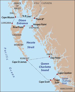
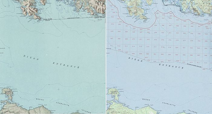
Dixon Entrance
Encyclopedia
Strait
A strait or straits is a narrow, typically navigable channel of water that connects two larger, navigable bodies of water. It most commonly refers to a channel of water that lies between two land masses, but it may also refer to a navigable channel through a body of water that is otherwise not...
about 80 kilometres (49.7 mi) long and wide in the Pacific Ocean
Pacific Ocean
The Pacific Ocean is the largest of the Earth's oceanic divisions. It extends from the Arctic in the north to the Southern Ocean in the south, bounded by Asia and Australia in the west, and the Americas in the east.At 165.2 million square kilometres in area, this largest division of the World...
at the International Boundary between the U.S.
United States
The United States of America is a federal constitutional republic comprising fifty states and a federal district...
state of Alaska
Alaska
Alaska is the largest state in the United States by area. It is situated in the northwest extremity of the North American continent, with Canada to the east, the Arctic Ocean to the north, and the Pacific Ocean to the west and south, with Russia further west across the Bering Strait...
and the province of British Columbia
British Columbia
British Columbia is the westernmost of Canada's provinces and is known for its natural beauty, as reflected in its Latin motto, Splendor sine occasu . Its name was chosen by Queen Victoria in 1858...
in Canada
Canada
Canada is a North American country consisting of ten provinces and three territories. Located in the northern part of the continent, it extends from the Atlantic Ocean in the east to the Pacific Ocean in the west, and northward into the Arctic Ocean...
. It was named by Joseph Banks
Joseph Banks
Sir Joseph Banks, 1st Baronet, GCB, PRS was an English naturalist, botanist and patron of the natural sciences. He took part in Captain James Cook's first great voyage . Banks is credited with the introduction to the Western world of eucalyptus, acacia, mimosa and the genus named after him,...
for Captain George Dixon, a Royal Navy
Royal Navy
The Royal Navy is the naval warfare service branch of the British Armed Forces. Founded in the 16th century, it is the oldest service branch and is known as the Senior Service...
officer, fur trader
Fur trade
The fur trade is a worldwide industry dealing in the acquisition and sale of animal fur. Since the establishment of world market for in the early modern period furs of boreal, polar and cold temperate mammalian animals have been the most valued...
, and explorer, who surveyed the area in 1787. The Dixon Entrance is part of the Inside Passage
Inside Passage
The Inside Passage is a coastal route for oceangoing vessels along a network of passages which weave through the islands on the Pacific coast of North America. The route extends from southeastern Alaska, in the United States, through western British Columbia, in Canada, to northwestern Washington...
shipping route. It forms part of the maritime boundary
Maritime boundary
Maritime boundary is a conceptual means of division of the water surface of the planet into maritime areas that are defined through surrounding physical geography or by human geography. As such it usually includes areas of exclusive national rights over the mineral and biological resources,...
between the U.S. and Canada, although the location of that boundary here is disputed. A name used in the Haida
Haida language
The Haida language is the language of the Haida people. It contains seven vowels and well over 30 consonants.-History:The first documented contact between the Haida and Europeans was in 1774, on Juan Pérez's exploratory voyage. At this time Haidas inhabited the Queen Charlotte Islands, Dall...
is Seegaay, which means only "ocean".
The Dixon Entrance lies between Clarence Strait
Clarence Strait
Clarence Strait, originally Duke of Clarence Strait, is a strait in southeastern Alaska, in the United States in the Alexander Archipelago. The strait separates Prince of Wales Island, on the west side, from Revillagigedo Island and Annette Island, on the east side...
in the Alexander Archipelago
Alexander Archipelago
The Alexander Archipelago is a long archipelago, or group of islands, of North America off the southeastern coast of Alaska. It contains about 1,100 islands, which are the tops of the submerged coastal mountains that rise steeply from the Pacific Ocean. Deep channels and fjords separate the...
in Alaska
Alaska
Alaska is the largest state in the United States by area. It is situated in the northwest extremity of the North American continent, with Canada to the east, the Arctic Ocean to the north, and the Pacific Ocean to the west and south, with Russia further west across the Bering Strait...
to the north, and Hecate Strait
Hecate Strait
Hecate Strait is a wide but shallow strait between the Haida Gwaii and the mainland of British Columbia, Canada. It merges with Queen Charlotte Sound to the south and Dixon Entrance to the north...
and the islands known as Haida Gwaii (the Queen Charlotte Islands) in British Columbia
British Columbia
British Columbia is the westernmost of Canada's provinces and is known for its natural beauty, as reflected in its Latin motto, Splendor sine occasu . Its name was chosen by Queen Victoria in 1858...
, to the south. Prince of Wales Island, Alaska
Prince of Wales Island, Alaska
Prince of Wales Island is one of the islands of the Alexander Archipelago in the Alaska Panhandle. It is the fourth-largest island in the United States and the 97th-largest island in the world....
, is the largest of the Alaskan islands on the north side of the entrance, and is also home to a branch of the Haida, known as the Kaigani Haida. Members of the Haida nation maintain free access across the Strait.
The so-called "A-B Line" (approximately 54°40'N), which marks the northern boundary of the Dixon Entrance, was delineated during the 1903 Alaska Boundary Treaty
Hay-Herbert Treaty
The Alaska boundary treaty, also known as the Hay–Herbert treaty, signed in 1903, is a treaty between Great Britain and United States that resolved a dispute on the location of the border between Alaska and Canada....
. The meaning of the line remains in dispute between Canada and the United States. Canada claims the line is the international maritime boundary, while the United States holds that its purpose was only to designate which islands belonged to which country, and holds that the maritime boundary is an equidistant line between islands. Territorial fishing disputes between the countries remain today, as the United States does not recognize the A-B Line for purposes of seafloor resources or fishing rights and has never shown the treaty boundary on its own official maps.
See also
- Alaska boundary disputeAlaska Boundary DisputeThe Alaska boundary dispute was a territorial dispute between the United States and Canada . It was resolved by arbitration in 1903. The dispute had been going on between the Russian and British Empires since 1821, and was inherited by the United States as a consequence of the Alaska Purchase in...
- List of areas disputed by the United States and Canada