
Districts of Afghanistan
Encyclopedia
The provinces
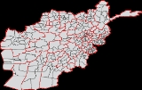
Provinces of Afghanistan
The provinces of Afghanistan are the primary administrative divisions of Afghanistan. As of 2004, there are thirty-four provinces in the country. Each province is further divided into smaller districts....
of Afghanistan
Afghanistan
Afghanistan , officially the Islamic Republic of Afghanistan, is a landlocked country located in the centre of Asia, forming South Asia, Central Asia and the Middle East. With a population of about 29 million, it has an area of , making it the 42nd most populous and 41st largest nation in the world...
are divided into Wolaswalei or district
District
Districts are a type of administrative division, in some countries managed by a local government. They vary greatly in size, spanning entire regions or counties, several municipalities, or subdivisions of municipalities.-Austria:...
s. The number of districts in Afghanistan has fluctuated over the years, with new districts created by splitting or merging parts of others. Prior to 1979, there were 325 districts. This was increased to 329 and, in 2004, a major reorganization led to the number increasing to 397. As of June 2005, the Afghan Ministry of the Interior recognised 398 districts, divided between the 34 provinces. This number is expected to change with further administrative reorganization.
The districts are listed below, by province:
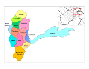
Badakhshan ProvinceBadakhshan ProvinceBadakhshan is one of the 34 provinces of Afghanistan, consisting of 28 districts. It is located in the north-east of the country, between the Hindu Kush and the Amu Darya. It is part of the Badakhshan region.-Geography:...
- Detailed Information of Badakhshan Province
- Current Map of the Districts of Badakhshan
- Arghanj Khwa - formerly part of Fayzabad District
- ArgoArgo DistrictArgo District is a district in Badakhshan Province, Afghanistan. It was created in 2005 from part of Fayzabad District and is home to approximately 45,000 residents.-References:...
- formerly part of Fayzabad District - BaharakBaharak DistrictBaharak district is a district of Badakhshan Province, Afghanistan located east of Fayzabad. The capital is the city of Baharak and the district is home to approximately 14,000 residents. The district is also called Baharakstan....
- Darayim - formerly part of Fayzabad District
- DarwazDarwaz districtDarwaz distrcit is a district in Badakhshan Province in Afghanistan. It is part of the historic region Darwaz which is now divided between Afghanistan and Tajikistan. Darwaz District has a population of approximately 21,000 after sub-division in 2005 which led to the formation of Darwazi Bala...
- Darwazi Bala - formerly part of Darwaz District
- FayzabadFayzabad District, BadakhshanFayzabad District is one of 30 districts that comprise Badakhshan Province, Afghanistan. In 2005, several portions of the district were sub-divided to create several new districts within the province. The remaining portion is home to approximately 46,000 residents.Settlements in the district...
- IshkashimIshkashim DistrictIshkashim District is one of the 29 districts of Badakhshan Province in eastern Afghanistan. The capital is the city of Ishkashim . The people of the region are called Tajiks and some of them speak the Ishkashimi language...
- JurmJurm DistrictJurm District is one of the 30 districts of Badakhshan Province in northeast Afghanistan. The district capital is a town named Jurm. The district is 3 hours far from the center of the province and is home to approximately 3,000 residents, making it one of the most sparsely populated portions of the...
- KhashKhash DistrictKhash District is one of the 29 districts of Badakhshan Province, Afghanistan. It was created in 2005 from part of Jurm District and is home to approximately 48,000 residents, making it the third most populous district of the province....
- formerly part of Jurm District - Khwahanولسوالی خواهان
- KishimKishim DistrictKishim District is one of the 29 districts of Badakhshan Province in eastern Afghanistan. The district is located in the Keshem Valley, a primarily rural area on the western edge of the province, and is home to approximately 63,000 residents, making it the second most populous district of the...
- Kohistan - formerly part of Baharak District
- Kuf Ab - formerly part of ولسوالی خواهان Khwahan District
- Kuran Wa MunjanKuran wa Munjan DistrictKuran wa Munjan District is one of the 29 districts of Badakhshan Province in eastern Afghanistan. Located in the Hindu Kush mountains, the district is home to approximately 8,000 residents. The district capital is Kuran wa Munjan....
- RaghRagh DistrictRagh District is one of the 29 districts of Badakhshan Province in eastern Afghanistan. Located in the northwestern portion of the province, Ragh is home to approximately 37,300 residents...
- Shahri BuzurgShahri Buzurg DistrictShahri Buzurg District is one of the 29 districts of Badakhshan Province in eastern Afghanistan. The capital is the city of Shahri Buzurg. Its northwestern border is along the international border between Afghanistan and Tajikistan while its southwestern border is with Takhar Province...
- ShighnanShighnan DistrictShighnan is one of the 29 districts of Badakhshan Province in eastern Afghanistan. It is part of the history region of Shighnan that is today divided between Afghanistan and Tajikistan...
- Shiki - formerly part of Fayzabad District
- ShuhadaShuhada DistrictShuhada District is one of the 29 districts of Badakhshan Province in eastern Afghanistan. The district was formed in 2005 from part of Baharak District and is home to approximately 31,000 residents....
- formerly part of Baharak District - Tagab - formerly part of Fayzabad District
- Tishkan - formerly part of Kishim District
- WakhanWakhan DistrictWakhan District is one of the 28 districts of Badakhshan Province in eastern Afghanistan. Total population for the district is about 13,000 residents. Wakhan District is bounded by three international borders: Tajikistan to the north, Pakistan to the south, and Afghanistan's only border with...
- Wurduj - formerly part of Baharak District
- Yaftali Sufla - formerly part of Fayzabad District
- Yamgan - formerly part of Baharak District
- YawanYawan DistrictYawan District is one of the 29 districts of Badakhshan Province in eastern Afghanistan. It was created in 2005 from part of Ragh District and is home to approximately 20,000 residents....
- formerly part of Ragh District - ZebakZebak DistrictZebak District is one of the 29 districts of Badakhshan Province in eastern Afghanistan. It is home to approximately 7,000 residents, most living in Zebak, the district capital. The Tajik peoples in the district speak Sanglechi-Ishkashmi language, also referred to as Zebaki....
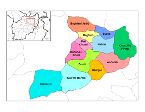
Baghlan Province
- Detailed Information of Baghlan Province
- Current Map of the Districts of Baghlan
- AndarabAndarab DistrictAndarab district is located in the southern part of Baghlan Province, Afghanistan. The estimated population of Andarab in 2004 was roughly 120,642. Tajiks make up the entire population of the district.. The district centre is the village of Andarab....
- BaghlanBaghlan DistrictBaghlan was a district in Baghlan Province, Afghanistan. The main town of the district was also known as Baghlan. In 2005, Baghlan was annexed into the district of Baghlani Jadid, also in Baghlan Province.-See also:...
- now part of Baghlani Jadid District - Baghlani JadidBaghlani Jadid DistrictBaghlani Jadid is a district of Baghlan Province in northern Afghanistan. It has a population of about 119,607.-Geography:...
- BurkaBurka DistrictBurka district is located in the northeastern part of Baghlan province. Its population is approximately 49,000 people. The capital is the city of Burka . It is located in the foothills of the Hindu Kush mountains. The district is prone to earthquakes.-External links:** by the UNHCR...
- Dahana i GhuriDahana i Ghuri DistrictDahana i Ghuri district is located in the most southwestern part of Baghlan province. The capital is Dahana i Ghuri . Its population is about 3,400 people. It is connected with Baghlan and Puli Khumri with an all weather primary road.-External links:*...
- Dih Salah - formerly part of Andarab District
- DushiDushi DistrictDushi district is located in the central part of Baghlan Province, Afghanistan. It lies on the major Kabul-Kunduz highway. The population of the district was estimated to be around 57,160 in 2004. Hazaras are around 60% of the population and make up the majority in the district, followed by 39%...
- Farang wa Gharu - formerly part of Khost Wa Fereng District
- Guzargahi Nur - formerly part of Khost Wa Fereng District
- KhinjanKhinjan DistrictKhinjan District is located in the southern part of Baghlan province in the Hindu Kush mountains. The capital is the town of Khenjan. The main Kabul-Kunduz highway passes through the district from south to west...
- Khost wa FerengKhost wa Fereng DistrictKhost wa Fereng district is the easternmost district of Baghlan province, Afghanistan in the Hindu Kush mountains. Its capital is Khost wa Fereng...
- Khwaja Hijran - formerly part of Andarab District
- NahrinNahrin DistrictNahrin District is a district in the central part of Baghlan Province in Afghanistan. To the west lie the major towns of Baghlan and Puli Khumri. The district centre is Nahrin City...
- Puli Hisar - formerly part of Andarab District
- Puli KhumriPuli Khumri DistrictPuli Khumri is a district of Baghlan Province, Afghanistan. The population of the district was estimated to be around 191,640 in 2004. Tajiks are around 50% of the population and make up the majority in the district, followed by 30% Pashtuns, 10% Hazaras and 10% Uzbeks.-External links:** by the...
- Tala Wa BarfakTala wa Barfak DistrictTala wa Barfak is a district of Afghanistan situated in the most southwestern part of Baghlan province. The capital is Taleh va Barfak.-External links:** by the UNHCR ....
- Andarab
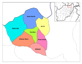
Kunduz Province
- Detailed Information of Kunduz Province
- Current Map of the Districts of Kunduz
- Ali AbadAli abad DistrictThe Ali abad District is situated in the southern part of Kunduz Province, Afghanistan. It borders with Baghlan Province to the South, Chahar dara District to the West, Kunduz and Khan Abad districts to the North and Takhar Province to the East...
- ArchiArchi DistrictThe Archi District is situated in the northwestern part of Kunduz Province in Afghanistan. It borders with Khan Abad and Kunduz districts to the South-West, Imam Sahib District to the North-West, Tajikistan to the Nort and Takhar Province to the East. The population is 74,900 - 40% Pashtun, 15%...
- Chahar DaraChahar dara DistrictChahar Dara District is one of the seven districts in Kunduz Province in northern Afghanistan...
- Imam SahibImam Sahib DistrictImam Sahib District is situated in the northern part of Kunduz Province, Afghanistan. It borders with Qalay-I-Zal District to the west, Tajikistan to the north , with Archi District to the east and Kunduz District to the south. The population is 204,300 - 25% Pashtun, 25% Tajik, 45% Uzbek and 5%...
- Khan AbadKhan Abad DistrictKhan Abad District is situated in the eastern part of Kunduz Province, Afghanistan. It borders Kunduz District to the west, Archi District to the northeast, Takhar Province to the east and Ali abad District to the south. The population is 140,600 : 40% Pashtun, 20% Hazara, 25% Tajik, 10% Uzbek and...
- KunduzKunduz DistrictKunduz District is situated in the center of Kunduz Province in Northern Afghanistan, around the provincial capital - the city of Kunduz. It borders Chahar dara District to the west, Qalay-I-Zal and Imam Sahib districts to the north, Archi and Khan Abad districts to the east and Ali abad District...
- Qalay-I-ZalQalay-I-Zal DistrictQalay-I-Zal District is situated in the western part of Kunduz Province, northern Afghanistan. It borders Balkh Province to the west and Tajikistan to the north along the Panj, Vakhsh and Amu Darya rivers. To the east it borders Imam Sahib District and to the south Kunduz and Chahar dara districts....
- Ali Abad
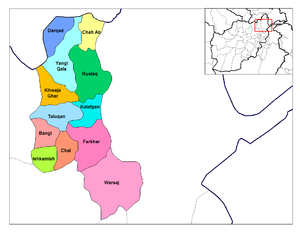
Takhar ProvinceTakhar ProvinceTakhār is one of the thirty-four provinces of Afghanistan. It was established in 1964 when Qataghan Province was divided into three provinces: Baghlan, Kunduz and Takhar. It is in the north-east of the country. Its capital is Taloqan. Its salt mines are one of Afghanistan's major mineral resources...
- Detailed Information of Takhar Province
- Current Map of the Districts of Takhar
- BaharakBaharak District, TakharBaharak District is a district of Takhar Province, Afghanistan. District was split-off from Taluqan District.- External links :* in Baharak District, 2009...
- formerly part of Taluqan District - BangiBangi DistrictBangi District is a district of Takhar Province, Afghanistan....
- Chah AbChah Ab DistrictChah Ab District is a district of Takhar Province, Afghanistan.-Location:Chah Ab is the fourth largest district of Takhar province and is located in the northeast of Afghanistan.-Demographics:...
- ChalChal DistrictChal District is a district of Takhar Province, Afghanistan....
- DarqadDarqad DistrictDarqad District is a district of Takhar Province, Afghanistan....
- Dashti QalaDashti Qala DistrictDashte Qala District is a district of Takhar Province, Afghanistan. District was split-off from Khwaja Ghar District. this district is one of the best of Takhar that has best location and vurdured district,and this district is so closed to Tajikistan also it has an ancient place and most popular in...
- formerly part of Khwaja Ghar District - FarkharFarkhar DistrictFarkhar District is a district of Takhar Province, Afghanistan.It is located in southern east of Taloqan city the center of Takhar province. It is a scenic valley surrounded with high mountains. The Khanabad River flows inside this valley. People from all around Afghanistan come to this valley for...
- Hazar SumuchHazar Sumuch DistrictHazar Sumuch District is a district of Takhar Province, Afghanistan. District was split-off from Taluqan District....
- formerly part of Taluqan District - IshkamishIshkamish DistrictIshkamish District is a district of Takhar Province, Afghanistan....
- KalafganKalafgan DistrictKalafgan District is a district of Takhar Province, Afghanistan....
- Khwaja Baha WuddinKhwaja Baha Wuddin DistrictKhwaja Baha Wuddin District is a district of Takhar Province, Afghanistan. District was split-off from Yangi Qala District....
- formerly part of Yangi Qala District - Khwaja GharKhwaja Ghar DistrictKhwaja Ghar District is a district of Takhar Province, Afghanistan....
- Namak AbNamak Ab DistrictNamak Ab District is a district of Takhar Province, Afghanistan. District was split-off from Taluqan District....
- formerly part of Taluqan District - RustaqRustaq DistrictRustaq District is a district of Takhar Province, northern Afghanistan. The district capital is the town of Rustaq....
- TaluqanTaluqan DistrictTaluqan District is a district of Takhar Province, northern Afghanistan. It contains the capital, Taloqan....
- WarsajWarsaj DistrictWarsaj District is a district of Takhar Province, northern Afghanistan....
- Yangi QalaYangi Qala DistrictYangi Qala District is one of the biggest districts in Takhar Province, Afghanistan. Economically the population of this district is involve in agriculture and some other small business. The field crop is rice and wheat, mostly the surplus rice is exporting to the neighboring district and...
- Baharak
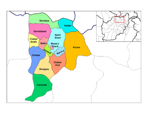
Balkh ProvinceBalkh ProvinceBalkh is one of the thirty-four provinces of Afghanistan. It is in the north of the country and its name derives from the ancient city of Balkh, near the modern town...
- Detailed Information of Balkh Province
- Current Map of the Districts of Balkh
- Balkh
- Chahar BolakChahar Bolak DistrictChahar Bolak district is located in the western part of Balkh Province. Its capital is the village of Chahar Bolak 40 km northwest of Mazari Sharif....
- Chahar Kint
- ChimtalChimtal DistrictChimtal District is located in the western part of Balkh province, Afghanistan. The estimated population of Chimtal in 2004 was around 81,311. The capital is Chimtal ....
- DawlatabadDawlatabad DistrictDawlatabad District is located in the northwestern part of Balkh province, Afghanistan. The population is over 94,000 people. The capital is the city of Dawlatabad at 298 m height above the sea level.-Not to be confused with:...
- DihdadiDihdadi DistrictDihdadi District is situated in the central part of Balkh province, Afghanistan. It is not far from the capital of the province Mazari Sharif - about 15 km in eastern direction from the district capital Dihdadi ....
- KaldarKaldar DistrictKaldar is a small district in the northern part of Balkh Province, Afghanistan. The northern and the eastern border of the district is the large Amu Darya river. North of the river is Uzbekistan and east is Tajikistan. The main village, also called Kaldar, is in the northeastern part of the...
- Khulmi
- KishindihKishindih DistrictKishindih district is the southernmost district in Balkh province. Its capital is Kishindinh Bala, situated in the northern part of the district....
- MarmulMarmul DistrictMarmul is a small district, located in the central part of Balkh province. The capital Marmul is in its southern end on the border with the Chahar Kint district....
- Mazar-e Sharif
- Nahri ShahiNahri Shahi DistrictNahri Shahi is a large district of Balkh Province, Afghanistan around the capital district Mazari Sharif....
- SholgaraSholgara DistrictSholgara is a district in the southern part of Balkh Province, Afghanistan. It is located at a crossroads between several districts, just south of Mazari Sharif...
- ShortepaShortepa DistrictShortepa is a small district in Balkh Province, Afghanistan. It is situated along the Amu Darya river, close to the border with Uzbekistan. The main village is Shor Tappeh at 274 m altitude.-External links:*...
- ZariZari DistrictZari is a district in Balkh Province, Afghanistan. It was created in 2005 from part of Kishindih District....
- formerly part of Kishindih District
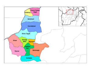
Faryab ProvinceFaryab ProvinceFāryāb is one of the thirty-four provinces of Afghanistan. It is in the north of the country. Its capital is Maymana. The majority of the population is Uzbek.-History:...
- Detailed Information of Faryab Province
- Current Map of the Districts of Faryab
- AlmarAlmar DistrictAlmar is a district in the southwestern part of Faryab Province, Afghanistan. Its northern border is the national border with Turkmenistan. The population was estimated at 55,000 in 2002....
- Andkhoy
- BilchiraghBilchiragh DistrictBilchiragh is a district in the southern part of Faryab Province, Afghanistan. The main town, Belcheragh, is situated in the northwest of the district at , 1263 m altitude.- External links:*...
- Dawlat AbadDawlat Abad DistrictDawlat Abad is a district in Faryab Province, Afghanistan. The population of the district was estimated 39,000 in 2002.The centre of the district is the town of Dawlat Abad , located at , 447 m altitude, on the route from Sheberghan to Maimana. At one time it had a bazaar with 180 shops and...
- GurziwanGurziwan DistrictGurziwan is a district in Faryab Province, Afghanistan. It was created in 2005 from part of Bilchiragh District....
- formerly part of Bilchiragh District - Khani Chahar BaghKhani Chahar Bagh DistrictKhani Chahar Bagh is the most northerly district in Faryab Province. The main village, Chahar Bagh , at 278 m altitude, is in the southern part of the district. In the north the district's border is with Turkmenistan. The population in 2002 was estimated at 22,000....
- Khwaja Sabz PoshKhwaja Sabz Posh DistrictKhwaja Sabz Posh District is the district where the Faryab Province capital Maymana is located. It is a rural district without its own capital....
- KohistanKohistan District, FaryabKohistan district is the southern-most district in Faryab Province. Its population is 38,200 . The district center is Qal'a , 1909 m altitude....
- Maymana
- Pashtun KotPashtun Kot DistrictPashtun Kot district is located in the center of Faryab Province southeast from Maymana. The district center Pashtun Kot is a suburb of Maymana . The population is 159,300 ....
- QaramqolQaramqol DistrictQaramqol district is located south of Andkhoy in the northern part of Faryab Province. The population is 17,100 . The district center Qaram Qũl is close to the town of Andkhoy....
- QaysarQaysar DistrictQaysar district is situated in the southwestern part of the Faryab Province of Afghanistan. The population is 122,300 people . The district center Qeysar , at the edge of the vast desert of Qaisar, has almost the same peculiarities of the Almar bazaar...
- QurghanQurghan DistrictQurghan is a district in Faryab Province, Afghanistan. It was created in 2005 from the western part of Andkhoy District. The district center Qurghan is very close to Andkhoy at 317 m altitude....
- formerly part of Andkhoy District - Shirin TagabShirin Tagab DistrictShirin-Tagab is the district center in the Faryab Province, Afghanistan. The population was 65,800 in 2004. It is located at , 525 m altitude....
- Almar
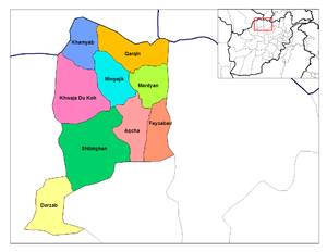
Jowzjan ProvinceJowzjan ProvinceJowzjān or Jōzjān or Jawzjan is one of the thirty-four provinces of Afghanistan. It is in the north of the country. Its capital is Sheberghan.- Demographics :...
- Detailed Information of Jowzjan Province
- Current Map of the Districts of Jowzjan
- AqchaAqcha DistrictAqcha District is situated in the central part of Jowzjan Province in northern Afghanistan. It borders Mardyan and Mingajik districts to the north, Sheberghan District to the West, Sar-e Pol Province to the south and Fayzabad District to the east. The population is more than 50,000 people...
- DarzabDarzab DistrictDarzab District is the southwesternmost district in Jowzjan Province, Afghanistan. It borders Sheberghan District to northeast, Sar-e Pol Province to the west and Faryab Province to the south and west. The population is 43,300 . The district center is Darzab.- District Map :*...
- FayzabadFayzabad District, JowzjanSee also: Faizabad Fayzabad District is situated in the eastern part of Jowzjan Province, Afghanistan. It borders Aqcha District to the west, Mardyan District to the north, Balkh Province to the east and Sar-e Pol Province to the south. The population is 36,800 . The district center is the village...
- KhamyabKhamyab DistrictKhamyab District is a frontier district in the province of Jozjan in Afghanistan. It shares borders with Turkmenistan to the north and west, Khwaja du koh District to the south and the Mingajik and Qarqin districts to the east. As of 2006, the population is 12,400. The district center is the...
- KhaniqaKhaniqa DistrictKhaniqa District is a district of Jowzjan Province, Afghanistan....
- formerly part of Aqcha District - Khwaja Du KohKhwaja du koh DistrictKhwaja du koh District is a district of Jowzjan Province, Afghanistan, situated in the Karakum Desert. It borders Faryab Province to the west, Khamyab District to the north, Mangajik District to the east and Sheberghan District to the south. The population is 23,900 . The district capital is Khwaja...
- MardyanMardyan DistrictMardyan District is situated in the central eastern part of the Jowzjan Province, Afghanistan. It borders Mingajik District to the west, Qarqin District to north, Balkh Province and Fayzabad District to the east and Aqcha District to the south. The population is 34,200...
- MingajikMingajik DistrictMangajik District is situated in the central part of Jowzjan Province, Afghanistan. It borders Khwaja du koh and Khamyab districts to the west, Qarqin District to the north, Mardyan District to the east and Aqcha District to the south. The population is 38,100...
- QarqinQarqin DistrictQarqin District is a small boundary district in the northern part of Jowzjan Province, Afghanistan. It borders Turkmenistan to the north along the Amu Darya River, Khamyab District to the west, Mingajik and Mardyan districts to the aouth, and Balkh Province to the east. The population is 21,400...
- Qush TepaQush Tepa DistrictQush Tepa District is a district of Jowzjan Province, Afghanistan....
- formerly part of Shibirghan District - ShibirghanShibirghan DistrictShibirghan District is situated in the southern part of Jowzjan Province in Afghanistan. It borders Faryab Province to the west, Khwaja du koh District to the north, Aqcha District to the east and Sar-e Pol Province. The population is 143,900 . The center is the provincial capital Sheberghan...
- Aqcha
Samangan ProvinceSamangan ProvinceSamangan is one of the thirty-four provinces of Afghanistan. The province covers and has a population of approximately 313,211, as of 2006.Its capital, Samangan, is known for its ancient ruins including, notably, the Takht e Rostam...
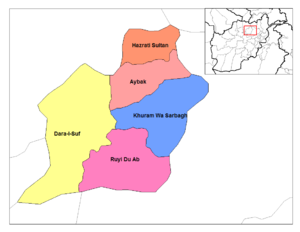
- Detailed Information of Samangan Province
- Current Map of the Districts of Samangan
- AybakAybak DistrictAybak District is a district in Samangan Province, Afghanistan. It contains the town of Aybak which serves as the provincial capital of Samangan....
- Dara-I-Sufi Balla - created within the former Dara-I-Suf District
- Dara-I-Sufi Payan - created within the former Dara-I-Suf District
- Feroz NakhchirFeroz Nakhchir DistrictFeroz Nakhchir District is a district of Samangan Province, Afghanistan. It formerly belonged to Balkh Province and shifted in 2005....
- formerly part of Khulmi District; shifted from Balkh Province - Hazrati SultanHazrati Sultan DistrictHazrati Sultan District is a district in Samangan Province, Afghanistan. It is also locally known as Azrat Sultan....
- Khuram Wa SarbaghKhuram Wa Sarbagh DistrictKhuram Wa Sarbagh District is a district in Samangan Province, Afghanistan....
- Ruyi Du AbRuyi Du Ab DistrictRuyi Du Ab District is a district in Samangan Province, northern Afghanistan....
- Aybak
Sare Pol ProvinceSar-e Pol ProvinceSar-e Pol, also spelled Sari Pul , is one of the thirty-four provinces of Afghanistan. It is in the north of the country. Sar-e-Pul Province is situated between the central highlands and the northern Turkmen plains. Sar-e-Pul borders Ghor and Baniyan provinces to the south, Faryab, Jawzjan and...
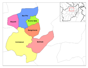
- Detailed Information of Sar-e-Pol Province
- Current Map of the Districts of Sar-e-Pol
- BalkhabBalkhab DistrictBalkhab District is a district of Sar-e Pol Province, Afghanistan. The district seat lies at Balkhab, also known as Tarkhoj.Coal is mined in the area.A massive copper deposit is also located in Balkhab district of Sar-e pol province, the new copper discovery is bigger than the current Aynak copper...
- GosfandiGosfandi DistrictGosfandi District is a district of Sar-e Pol Province, Afghanistan....
- formerly part of Sayyad District; most recently created district up to date - KohistanatKohistanat DistrictKohistanat District is a district of Sar-e Pol Province, Afghanistan.-Villages:*Aruj, Afghanistan*Gawanak*Jarghan*Jawak*Negala...
- SangcharakSangcharak DistrictSangcharak District or Sancharak is a district of Sar-e Pol Province, Afghanistan. Its center is the city of Tukzar or Tokzar. Sangcharak district borders Balkh Province in the east. Sangcharak District's area is 1089 square kilometres.- Population :...
- Sar-e Pul
- SayyadSayyad DistrictSayyad District is a district of Sar-e Pol Province, Afghanistan....
- Sozma QalaSozma Qala DistrictSozma Qala District is a district of Sar-e Pol Province, Afghanistan....
- Balkhab
Kabul ProvinceKabul ProvinceKābul , situated in the east of the country, is one of the thirty-four provinces of Afghanistan. The capital of the province is Kabul City, which is also Afghanistan's capital. The population of Kabul province is 3.5 million people as of 2009, of which almost 80 percent live in the urban areas...
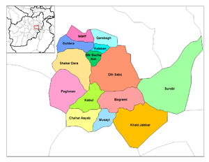
- Detailed Information of Kabul Province
- Current Map of the Districts of Kabul
- BagramiBagrami DistrictBagrami District is located in the central part of Kabul Province in Afghanistan. It is approximately 30 minutes drive east from the capital city, Kabul...
- Chahar Asyab
- Deh SabzDeh Sabz DistrictDeh Sabz District is situated northeast of Kabul City in Afghanistan. It has a population of 100,136 people . About 70% are Pashtuns, and 30% are Tajiks....
- FarzaFarza DistrictFarza District is a new district of Kabul Province, Afghanistan. It has a population of 18,000 people , a mixture of Pashtuns and Tajiks. In January 1991, Farza was separated as an independent district from Mir Bacha Kot District but this structure was never recognised by the Taliban government....
- formerly part of Mir Bacha Kot District - GuldaraGuldara DistrictGuldara District is located in the northwestern part of Kabul Province, Afghanistan. It has a population of 10,000 people, including new returnees...
- IstalifIstalif DistrictIstalif District is located in the northwestern part of Kabul Province, Afghanistan. It has a population of 8,500 , a mixture of Tajiks, Pashtuns and Hazaras....
- KabulKabul DistrictKabul District is a district of Kabul Province, Afghanistan. The seta lies at Kabul....
- KalakanKalakan DistrictKalakan District is located in the northern part of Kabul Province, Afghanistan. It borders Guldara District to the west, Qarabagh District to the north, Dih Sabz District to the east and Mir Bacha Kot District to the south. The population is 26,800 . The center is the village of Kalakan, situated...
- Khaki JabbarKhaki Jabbar DistrictKhaki Jabbar District is a mountainous district situated in the southeastern part of Kabul Province, Afghanistan. The district headquarter is Khak-i Jabbar village, which is located in the central part of the district.-Demographics:...
- Mir Bacha KotMir Bacha Kot DistrictMir Bacha Kot District is situated in the central part of Kabul Province, Afghanistan. It has a population of 5,000 and another 37,000 are expected to return in the near future...
- MussahiMussahi DistrictMussahi District is a district of Kabul province, Afghanistan.Location: is situated in the southern part of Kabul Province, Afghanistan. Mussai district borders Char Asiab District to the west, Bagrami District to the north, Khaki Jabbar District to the east and Logar Province to the south...
- PaghmanPaghman DistrictPaghman District is situated in the western part of Kabul Province, Afghanistan. It has a population of 120,000 people, and another 20,000 returnees are expected , of which 70% are Pashtuns and 30% Tajiks....
- Qarabagh
- ShakardaraShakardara DistrictShakardara District is situated in the central part of Kabul Province, Afghanistan. It has a population of 63,000 people, with another 10,000 expected to return from abroad...
- SurobiSurobi DistrictThis article is about the Surobi District of Kabul Province. For the district in Paktika, see Sarobi, Paktika.Surobi, Sarobi or Sarubi District is a district of Kabul Province, Afghanistan. Its capital, Surobi, lies about 60 kilometres east of Kabul along the A01 highway, although much of the...
- Bagrami
Kapisa ProvinceKapisa ProvinceKapisa is one of the 34 provinces of Afghanistan. It is in the north-east of the country. Its capital is Mahmud-i-Raqi, and other districts include Kohistan, Nijrab and Tagab. The population of Kapisa is estimated to be 364,900, although there has never been an official estimate...

- Detailed Information of Kapisa Province
- Current Map of the Districts of Kapisa
- AlasayAlasay DistrictThe Alasay District is situated in the eastern part of Kapisa Province, Afghanistan. It borders Tagab District to the South and East, Nejrab District to the North and Laghman Province to the East. The population is 33,500...
- Hesa Awal Kohistan - created within the former KohistanKohistan District, KapisaKohistan District was a district in Kapisa Province, Afghanistan. The district center was Kohistan. The population was 100,200 , mostly Tajik. The Kohistani Tajiks were the most powerful and best organized groups that fought against the British occupation of Kabul in 1879 to 1880....
District - Hesa Duwum KohistanHesa Duwum Kohistan DistrictHesa Duwum Kohistan District is a district in the southern part of Kapisa Province, Afghanistan. The center is the village of Keshektan. The population is 39,900 and is mostly composed of Tajik. The district is famous for its sweet mulberries, grapes, apricots and pomegranates. Yearly, hundreds of...
- created within the former Kohistan District - Koh BandKoh Band DistrictKoh Band District is situated in the northwestern part of Kapisa Province, Afghanistan. It borders Kohistan District to the west, Parvan Province to the north, Nejrab District to the east and Mahmud Raqi District to the south. The population is 20,800...
- Mahmud RaqiMahmud Raqi DistrictMahmud Raqi District is located in the western part of Kapisa Province, Afghanistan. It borders with Parvan Province to the south and with other districts from Kapisa Province: Nejrab District and the former Kohistan District to the north and Tagab District to the southeast. The district center is...
- NijrabNijrab DistrictNijrab District, also called Nijraaw, is situated in the central part of Kapisa Province, Afghanistan. It is located in a valley about 120 km north of Kabul. It borders Mahmud Raqi and Koh Band districts to the west, Parvan Province to the north, Laghman Province and Alasay District to the...
- Tagab
- Alasay
Logar Province
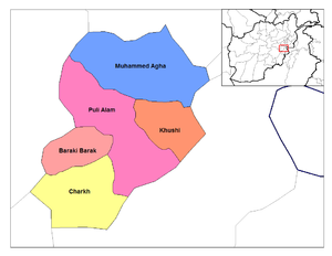
- Detailed Information of Logar Province
- Current Map of the Districts of Logar
- AzraAzra DistrictAzra District is a district of Logar Province, Afghanistan. It is located in the eastern part of the district and is 140km from the capital Kabul. It was moved from Paktia Province....
- shifted from Paktia Province - Baraki BarakBaraki Barak DistrictBaraki Barak District is situated in the western part of Logar Province, Afghanistan. It borders Wardak Province to the west and northwest, Pul-i-Alam District to the north and east and Kharwar and Charkh districts to the south. The population is 101,000...
- CharkhCharkh DistrictCharkh District is situated in the southern part of Logar Province, Afghanistan. Kharwar District was created from the former big Charkh District.The population is 39,400 . The district center is the village of Charkh, located on at 2108 m altitude in a river valley...
- KharwarKharwar DistrictKharwar District is a district of Logar Province, Afghanistan. In July 2008 a coalition helicopter was shot down by small arms fire, an American officer said he was worried about the rising violence in the area. It was created from Charkh District....
- formerly part of Charkh District - KhoshiKhoshi DistrictKhoshi District is located in the East part of Logar Province, Afghanistan. 80 km away from Kabul and 18 km from Pul-i-Alamcentre of Logar Province. Centre of the district is called Khoshi...
- Mohammad AghaMohammad Agha DistrictMohammad Agha District is a district of Logar Province, Afghanistan. It lies next to Kabul Province. The District capital is Mohammad Agha. the copper mine Mes Aynak is located within this district.-Geography:...
- Pul-i-AlamPul-i-Alam DistrictPul-i-Alam is a district of Logar Province, Afghanistan.The population of Pul-i-Alam is estimated at around 108,000, which is composed of Pashtuns, Tajiks and some Shia...
- Azra
Panjshir ProvincePanjshir ProvincePanjshir is one of the 34 provinces of Afghanistan. Containing the Panjshir Valley, in April 2004 it was created from parts of Parwan Province, which now lies along its southwestern border. Panjshir's population is about 139,000 and covers an area of 3,610 square kilometers...
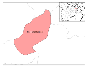
- Detailed Information of Panjsher Province
- Current Map of the Districts of Panjsher
- AnabaAnaba DistrictAnaba District is a district of Panjshir Province, Afghanistan....
- created within the former Panjsher District - BazarakBazarak DistrictBazarak District is a district of Panjshir Province, Afghanistan....
- created within the former Panjsher District - DarahDarah DistrictDarah District is a district of Panjshir Province, Afghanistan....
- created within the former Hisa Duwum Panjsher District - KhenjKhenj DistrictKhenj District is a district of Panjshir Province, Afghanistan. Emerald is mined in this part of Panjshir province....
- created within the former Hisa Awal Panjsher District - ParyanParyan DistrictParyan District is a district of Panjshir Province, Afghanistan....
- created within the former Hisa Awal Panjsher District - RokhaRokha DistrictRokha District is a district of Panjshir Province, Afghanistan....
- created within parts of the former Hisa Duwum Panjsher and Panjsher Districts - ShotulShotul DistrictShotul District is a district of Panjshir Province, Afghanistan....
- created within the former Panjsher District
- Anaba
Parwan Province
- Detailed Information of Parwan Province
- Current Map of the Districts of Parwan
- BagramBagram DistrictBagram District is a district of Parwan Province, Afghanistan. Its seat lies at Bagram, which lies about 60 kilometers north of the capital of Kabul...
- ChaharikarChaharikar DistrictChaharikar District is a district of Parwan Province, Afghanistan....
- GhorbandGhorband DistrictGhorband District is a district of Parwan Province, Afghanistan. Ghorband is located in the southern foothills of Hindu Kush and forms the western boundary of the ancient valley of Koh Daman. It is located 50 km from Kabul, the capital of Afghanistan. The capital lies at Syahgerd, also known as...
- Jabal Saraj
- Kohi SafiKohi Safi DistrictKohi Safi District is a district of Parwan Province, Afghanistan....
- SalangSalang DistrictSalang District is a district of Parwan Province, Afghanistan....
- Sayed KhelSayed Khel DistrictSayed Khel District is a district of Parwan Province, Afghanistan....
- formerly part of Jabul Saraj District - Shekh AliShekh Ali DistrictShekh Ali district Parwan Province.The main tribes of Shekh Ali's are: Daikakalan, Naiman , Qaraluq, Karmali and Babur are all Sunis. They are not Hazaras although some of the may look like Hazaras. The Qaraluqs are Turkik Origin. They have adopted mainly the Hazara cultures including the language,...
- ShinwariShinwari DistrictShinwari District is a district of Parwan Province, Afghanistan....
- Surkhi ParsaSurkhi Parsa DistrictSurkhi Parsa District is a district of Parwan Province, Afghanistan....
- Bagram
Wardak ProvinceWardak ProvinceMaidan Wardak Province is one of thirty four provinces of Afghanistan located in the central east region of Afghanistan. It has a population of approximately 540,100. The capital of the province is Maidan Shar...
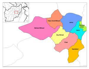
- Detailed Information of Wardak Province
- Current Map of the Districts of Wardak
- Chaki WardakChaki Wardak DistrictChaki Wardak or Čak-e-Wardak , literally : The Head of Wardak , is a district in the south of Wardak Province, Afghanistan. Its population was estimated at 83,376 in 2005, the last year for which figures are available...
- Day MirdadDay Mirdad DistrictDay Mirdad is a district in the south of Wardak Province, Afghanistan. The capital of the district is Miran city. The district was previously known as Jilga.-Demographics and population:...
- Hisa-I-Awali BihsudHisa-I-Awali Bihsud DistrictHisa-I-Awali Bihsud District is a district of Wardak Province, Afghanistan.The district has a Hazara majority resident population, but the district is also used as grazing ground by nomadic Pashtun Kuchis....
- JaghatuJaghatu DistrictJaghatu is a district in Wardak province, Afghanistan, 40 km northwest of Ghazni. In 2004 it was shifted from Ghazni province to Wardak. According to 2005 data, the population is more than 27,000, most of whom are Hazara...
- shifted from Ghazni Province - JalrezJalrez DistrictJalrez is a district in the east of Maydan Shahr, Wardak Province, Afghanistan. The district center is the village of Jalrez.-External links:...
- Markazi BihsudMarkazi Bihsud DistrictMarkazi Bihsud District is a district of Wardak Province, Afghanistan.The district has a Hazara majority resident population, but the district is also used as grazing ground by nomadic Pashtun Kuchis....
- Maydan ShahrMaydan Shahr DistrictMaydan Shahr is a district in the east of Wardak Province, Afghanistan. Its population was estimated at 121,531 in 2002, consisting of about 85% Pashtuns and 14% Tajiks, with a few Hazara families. The district centre is Maydan Shahr.-References:...
- NirkhNirkh DistrictNirkh is a district of about 480 square kilometres in the east of Wardak Province, Afghanistan. Its population was estimated at 57,000 in 2002, consisting of about 80% Pashtuns, 15% Tajiks and 5% Hazara...
- SaydabadSaydabad DistrictSaydabad District is a district of Wardak Province, Afghanistan. The district is known for its pleasant climate, including hilly vegetation, streams, and orchards...
- Chaki Wardak
Kunar ProvinceKunar ProvinceKunar is one of the 34 provinces of Afghanistan, located in the northeastern part of the country. Its capital is Asadabad. It is one of the four "N2KL" provinces...
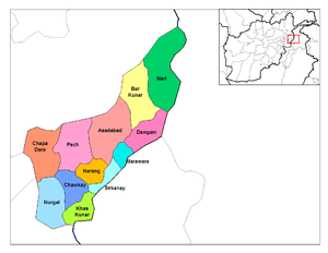
- Detailed Information of Kunar Province
- Current Map of the Districts of Kunar
- AsadabadAsadabad districtAsadabad district is one of 15 districts in Kunar Province, Afghanistan. It includes the city of Asadabad - the district center, close the Kunar River. It is situated in the central part of the province...
- Bar KunarBar Kunar districtBar Kunar District is situated in the northeastern part of Kunar Province, Afghanistan. It borders Asadabad district to the southwest, Nuristan Province to the northwest, Nari district to the northeast and Dangam district to the southeast. The population is 19,500 - all Pashtun...
- Chapa DaraChapa Dara districtChapa Dara District is situated in the western part of Konar Province, Afghanistan and borders Nuristan Province. The population is 27,500 . The district is mountainous and farming and animal husbandry are not possible in the whole district. Some people work abroad...
- ChawkayChawkay districtChawkay District is situated in the central part of Kunar Province, Afghanistan. The population is 31,600 . The district center is the village of Chawkay at 726 m altitude in the valley of the Kunar river. 80 % of the houses in the district were destroyed during the wars.**...
- DangamDangam districtDangam District is situated in the eastern end of Kunar Province, Afghanistan. It borders Marawara district to the west, Asadabad district to the northwest, Bar Kunar district to the north, Nari district to the northeast and Pakistan to the east and south. The district is mountainous and poor. The...
- Dara-I-PechDara-I-Pech DistrictDara-I-Pech District is located western-central part of Kunar Province, Afghanistan, 30 km West from Asadabad. The population is 48,400 . The district is governed from Mano Gai...
- GhaziabadGhaziabad district, Kunar ProvinceGhaziabad District is situated in the northern part of Kunar Province, Afghanistan. It was created in 2004 from the northern part of Bar Kunar District. The population is 7,500 . The district center is the village of Ghaziabad at 1271 m altitude. The area is mountainous and there is little arable...
- formerly part of Nurgal District - Khas KunarKhas Kunar districtKhas Kunar District is the largest district in the Kunar Province, Afghanistan. It is situated in the southern part of the province and borders Nangarhar Province to the south and Pakistan to the east. The Kunar River passes north through the district and irrigates the surrounding land. The...
- MarawaraMarawara DistrictMarawara District is one of the 15 districts in Kunar Province, Afghanistan, bordering Pakistan to the east. It borders Sirkanay district to the west, Asadabad district to the westand northwest and asmar district to northeast. Marawara's population is not exactly known but CSO and UN figures...
- Narang Wa BadilNarang wa Badil districtNarang wa Badil District is situated in the central part of Kunar Province, Afghanistan south of Asadabad. It is surrounded by high mountains and the Kunar River. The population is 26,700 . The district center is the village of Kuz Narang at 742 m altitude. The arable land is not much and is not...
- NariNari districtNari District is a boundary mountainous district in the most eastern part of Kunar Province in Afghanistan. It borders Bar Kunar District to the west, Nuristan Province to the north, Pakistan to the east and Dangam district to the south. The population is 24,500 —60% of them Pashtun...
- NurgalNurgal DistrictNurgal District is situated in the western part of Kunar Province, Afghanistan, 90 km West from Asadabad, and is near Jalalabad city. It borders Nangarhar Province to the west and south, Chapa Dara district to the north and Chawkay and Khas Kunar districts to the east. The population is 28,000...
- Shaygal Wa ShiltanShaygal Wa Shiltan districtShaygal Wa Shiltan district was split from Chapa Dara district in Kunar Province, Afghanistan and the population is 25,900 ....
- formerly part of Chapa Dara District - SirkanaySirkanay districtSirkanay District is situated in the central part of Kunar Province, Afghanistan. It borders Pakistan to the south. The population is 24,200 . The district administrative center is the village of Serkanay at 775 m altitude. To the north the district borders the Kunar River, which irrigates the...
- Wata PurWata Pur districtWatapur District is situated in the central part of Kunar Province, Afghanistan. It was split from Asadabad district. The district is mountainous with 60 big and small villages. The population is 24,300 . The villages are located in the valleys or in the high mountains, with difficult or no road...
- formerly part of Asadabad District
- Asadabad
Laghman Province
- Detailed Information of Laghman Province
- Current Map of the Districts of Laghman
- AlingarAlingar DistrictAlingar District is located approximately 27 km from Mehtarlam, the provincial capital of Laghman Province and borders with Alishing and Dawlat Shah districts to the West, Nuristan Province to the North, Kunar and Nangarhar provinces to the East and Qarghayi and Mihtarlam districts to the...
- AlishingAlishing DistrictAlishing District is located in 21 km from Mihtarlam, the provincial centre of Laghman Province, and borders Kabul Province. It borders with Kabul and Kapisa provinces to the West, Dawlat Shah District to the North, Alingar District to the East and Mihtarlam District to the South. The population is...
- Dawlat ShahDawlat Shah DistrictDawlat Shah District is located approximately 74 km from Mehterlam, the provincial centre of Laghman Province. It is a mountainous district and borders Nuristan Province to the North and North-East, Alingar District to the East, Alishing District to the South and Kapisa and Parwan provinces to...
- MihtarlamMihtarlam DistrictMehterlam district is located in the center of Laghman Province and consists of the urban centre and provincial capital Mihtarlam and 24 major villages and 269 sub-villages. Mihtarlam derives its name from Mihtarlam baba , who was purported to be the father of the prophet Noah...
- QarghayiQarghayi DistrictQarghayi District has 60 villages. It is the largest district in Laghman Province, and is located 30 km from the provincial centre of Mihtarlam. It borders Mihtarlam District to the north, Alingar District to the northeast, Nangarhar Province to the south and Kabul Province to the west. The...
- Alingar
Nangarhar ProvinceNangarhar ProvinceNangarhar is one of the 34 provinces of Afghanistan in the east of the country. Its capital is the city of Jalalabad. The population of the province is 1,334,000, which consists mainly of ethnic Pashtuns with a sizable community of Arabs and Pashais....
- Detailed Information of Nangarhar Province
- Current Map of the Districts of Nangarhar
- AchinAchin DistrictAchin is a district in the south of Nangarhar Province, Afghanistan, bordering on Pakistan. Its population is 100% Pashtun.Achin is home to the Shinwari tribe, one of the largest Pashtun tribes. It was a stronghold of the Mujaheddin during the Soviet occupation of Afghanistan.-Economy:The primary...
- Bati KotBati Kot DistrictBati Kot is a district in the east of Nangarhar Province, Afghanistan. Its population, which is 100% Pashtun, was estimated at 63,960 in 2002, of whom 25,500 were children under 12. The district centre is Nader Shah Kot....
- BihsudBihsud DistrictBihsud District is a district of Nangarhar Province, Afghanistan. The district, which contains 40 villages, is located around the city Jalalabad, spanning both sides of the Kabul River...
- formerly part of Jalalabad District - ChaparharChaparhar DistrictChaparhar is a district in the centre of Nangarhar Province, Afghanistan. Its population, which is 100% Pashtun, was estimated at 54,858 in 2002, of whom 21,800 were children under 12. The district centre is the village of Chaparhar.-External links:...
- Dara-I-NurDara-I-Nur DistrictDara-I-Nur is a district in the north of Nangarhar Province, Afghanistan. Its population, which is 99% Pashai with a small number of Pashtuns, was estimated at 120,000 in 2002, of whom 28,000 were children under 12....
- Dih BalaDih Bala DistrictDih Bala is a district in the south of Nangarhar Province, Afghanistan, bordering on Pakistan. Its population, which is 100% Pashtun, was estimated at 50,595 in 2002, of whom 20,200 were children under 12. The district centre is Deh Bala....
- Dur BabaDur Baba DistrictDur Baba is a district in the southeast of Nangarhar Province, Afghanistan, bordering Pakistan. Its population, which is 100% Pashtun , was estimated at 29,197 in 2002, of whom 11,600 were children under 12. The district centre is the village of Dur Baba....
- GoshtaGoshta DistrictGoshta District is located in the northeast of Nangarhar Province, Afghanistan and borders Pakistan. The district's population is 100% Pashtun and was estimated at 160,000 in 2002, of whom 30,000 were children under 12...
- HisarakHisarak DistrictHesarak or Hisarak is a district in the west of Nangarhar Province, Afghanistan. Its population, which is 100% Pashtun, was estimated at 28,462 in 2002, of whom 11,380 were children under 12. The district centre is the village of Hesarak....
- Jalalabad
- KamaKama DistrictKama is a district in Nangarhar Province, Afghanistan, to the east of Jalalabad. Its population, which is 100% Pashtun, was estimated at 88,000 in 2002.The district centre is the village of Sanger Srye Kama....
- KhogyaniKhogyani DistrictKhogyani is a district in the south of Nangarhar Province, Afghanistan, bordering on Pakistan. Its population is almost entirely Pashtun, and was estimated at 146,852 in 2002. The district centre is the village of Khogyani, though the largest village is Vazir....
- KotKot DistrictKot is a district in the north of Nangarhar Province, Afghanistan. Oranges, rice, and sugarcane grow in the fertile district, and the capital city has cane-processing and sugar-refining as well as paper-making industries. The district's year-round summery weather attracts many visitors....
- formerly part of Rodat District - Kuz KunarKuz Kunar DistrictKuz Kunar is a district in the north of Nangarhar Province, Afghanistan, on the Kunar River. It is counted one of the more secured districts of the Nangarhar province, where many foreigners go to visit the social, agricultural and structural rehabilitation of the area...
- Lal PurLal Pur DistrictLal Pur is a district in the east of Nangarhar Province, Afghanistan, bordering Pakistan. Its population, which is 100% Pashtun, was estimated at 34,516 in 2002, of whom 13,800 were children under 12. The district centre is the village of Lal Pur....
- Muhmand DaraMuhmand Dara DistrictMomand Dara is a district in the east of Nangarhar Province, Afghanistan, bordering Pakistan. Its population, which is 100% Pashtun, was estimated at 33,966 in 2002, of whom 14,800 were children under the age of 12. The district centre is the village of Momand Dara...
- NazyanNazyan DistrictNazyan is a district in the south-east of Nangarhar Province, Afghanistan. Its population, which is 100% Pashtun, was estimated at 22,858 in 2002, of whom 9000 were children under 12. The district centre is the village of Nazyan....
- Pachir Wa AgamPachir Wa Agam DistrictPachir Wa Agam is a district in the southeast of Nangarhar Province, Afghanistan, bordering Pakistan. Its population, which is 100% Pashtun, was estimated at 39,280 in 2002, of whom 15,700 were children under 12. The district centre is the village of Pachir Wa Agam.The district has faced heavy...
- RodatRodat DistrictRodat is a district in the center of Nangarhar Province, 25 km away from Jalalabad city. Afghanistan, south of Jalalabad...
- SherzadSherzad DistrictSherzad is a district in the west of Nangarhar Province, Afghanistan. It has a short stretch of border with Pakistan. Its population, which is 100% Pashtun, was estimated at 66,392 in 2002, of whom 26,500 were children under 12...
- ShinwarShinwar DistrictShinwar is a district in Nangarhar Province, Afghanistan. It is on the main highway from Jalalabad to the Torkham border crossing. Its population, which is 100% Pashtun, was estimated at 40,147 in 2002, of whom 16,000 were children under 12. The district centre is the village of Shinwar...
- Surkh RodSurkh Rod DistrictSurkh-Rōd , also spelled as Surkh-Rūd or Sorkh-Rūd, is a district in the north of Nangarhar Province, Afghanistan. The district centre is the town of Sultanpur...
- Achin
Nuristan Province
- Detailed Information of Nurestan Province
- Current Map of the Districts of Nurestan
- Bargi Matal
- Du AbDu Ab DistrictDu Ab District, Dō Āb District, Du'ab District, Doab District, is a district of Nuristan Province, in eastern Afghanistan.-History:The Taliban launched an attack on the Du Ab and Qatar Khak areas on 31 January 1997.-References:...
- formerly part of Kamdesh District - KamdeshKamdesh DistrictKamdesh District is a district of Nuristan Province in eastern Afghanistan. It was originally in Konarha Province and then was moved to the newly created Nuristan Province in 2001.-Boundaries:...
- MandolMandol DistrictMandol District is a district of Nuristan Province in eastern Afghanistan. It was originally in Laghman Province and then was moved to the newly created Nuristan Province in 2001....
- NurgaramNurgaram DistrictNurgaram District is a district of Nuristan Province in Afghanistan. It was established in the 2004 Afghanistan administrative reorganization out of parts of Nuristan District and Wama District....
- formerly part of Kamdesh District - Paroon
- WamaWama DistrictWama District is a district of Nuristan Province in Afghanistan. In the 2004 Afghanistan administrative reorganization it lost territory to the newly created Nurgram and Parun districts....
- WaygalWaygal DistrictWaygal District is a district of Nuristan Province in eastern Afghanistan....
Badghis ProvinceBadghis ProvinceBādghīs is one of the thirty-four provinces of Afghanistan. It is located in northwestern Afghanistan, between the Murghab and Hari rivers, extending as far northward as the edge of the desert of Sarakhs. It includes the Chul formations through which the Turkmen-Afghan boundary runs...
- Detailed Information of Badghis Province
- Current Map of the Districts of Badghis
- Ab KamariAb Kamari DistrictAb Kamari is a district in the west of Badghis Province, Afghanistan. Its population was estimated at 36,300 in 2002, the ethnic makeup of which was approximately 80% Tajik with a Pashtun minority. The district capital is Sang Atesh. Other localities include Ab Khuda'i, Alkhan, Anjir, Duzdanak,...
- GhormachGhormach DistrictGhormach is a district situated in the north east Badghis Province of Afghanistan. The district centre is Ghowrmach.-Demographics:The estimated population of Ghormach District in 2003 was roughly 52,566...
- JawandJawand DistrictJawand is the largest district of Badghis Province, Afghanistan, located in the southeast. Its population is estimated at 186,000, although a 1990 estimate by the United States Agency for International Development puts the population at 46,403. Its capital is Jawand.Jawand has approximately 380...
- MuqurMuqur District, BadghisMuqur District is a district located within Badghis Province in the western part of Afghanistan. It is located between the districts of Ab Kamari to the east, Qala i Naw to the south, Qadis to the southeast and Murghab to the northeast. To the north is the national border with Turkmenistan...
- MurghabMurghab DistrictMurghab is a district situated in the northeast of Badghis Province, Afghanistan. The district capital is Murghab.-Demographics:The estimated population of Murghab District in 2003 was roughly 109,381...
- QadisQadis DistrictThe Qadis District is located in the southern part of Badghis province, Afghanistan, between the districts Jawand in the East, Qala i Naw in the west, Muqur and Murghab in the North. In the South is the Herat province. The capital is Qadis....
- Qala-I-Naw
- Ab Kamari
Bamyan Province
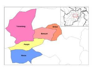
- Detailed Information of Bamiyan Province
- Current Map of the Districts of Bamiyan
- Bamyan
- KahmardKahmard DistrictKahmard is a district of Bamyan Province in central Afghanistan. It is located at an altitude of 1,475 meters, with a population of 31,042. Kahmard is situated 140 km from Bamiyan city, in the north of the province, and is divided into five valleys...
- shifted from Baghlan Province - PanjabPanjab DistrictPanjab district is in the central part of Bamiyan Province, Afghanistan. The capital is the town of Panjab. Panjab contains 5 valleys , the water running through the 5 valleys meet in the centre of the district...
- SayghanSayghan DistrictSaighan is a district in Bamyan Province, Afghanistan. It has a population of 23,215 . It was created in 2005 from part of Kahmard District, and until 2004 was part of Baghlan Province. Saighan city is the largest town in the district as well as being the administrative center. The district has...
- formerly part of Kahmard District; shifted from Baghlan Province - ShibarShibar DistrictShibar District is located in the western end of the Bamyan Province in Afghanistan. It is in a mountainous region. The main village Shibar is at 2,637 m altitude on the all-seasons secondary road from Bamyan to Kabul through the Shibar pass.The northern portion of the district, beginning near the...
- WarasWaras DistrictWaras District is a mountainous district in the southern part of Bamyan Province, Afghanistan. Its population is about 100,000 people, who are entirely Hazara, according to AIMS data. The main village is Waras...
- YakawlangYakawlang DistrictYakawlang District is located in the northwestern part of Bamyan Province. Its population is about 80,000 predominantly from the Hazara ethnic group. The capital city Yakawlang formerly held 60,000 residents, and it was completely destroyed by Taliban forces in 2001...
Farah ProvinceFarah ProvinceFarah is one of the thirty-four provinces of Afghanistan. It is in the southwest of the country. Its capital is Farah. Farah is a spacious and sparsely populated province that lies on the Iranian border...
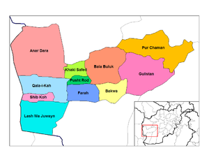
- Detailed Information of Farah Province
- Current Map of the Districts of Farah
- Anar DaraAnar Dara DistrictAnar Dara is a district in Farah Province, Afghanistan. Its population, which is approximately 70% Tajik with a Pashtun minority, was estimated at 30,000 in January 2005. The capital town, Anar Dara, is situated at 801 m altitude, with a population of about 13,300 people.-References:* , compiled...
- BakwaBakwa DistrictBakwa is a district in Farah Province, Afghanistan. Its population, which is entirely Pashtun, was estimated at 79,529 in November 2004. The district center is Sultani Bakwa. It is situated at 726 m altitude.-References:...
- Bala Buluk
- FarahFarah City DistrictFarah City District is a district in Farah Province, Afghanistan, containing the main city of Farah. Its population was estimated at 159,310 in 2004, composed of 85% Pashtun and 10% Tajik, along with other minor ethnic groups.-Popular perceptions:...
- GulistanGulistan DistrictGulistan, also transliterated as Golestan , is a district in Farah Province, Afghanistan. Its population, which is approximately 80% Pashtun with a Tajik minority, was estimated at 53,780 in October 2004. The main village, also called Gulistan, is situated at 1434 m altitude in the mountainous part...
- Khaki Safed
- Lash wa Juwayn
- Pur Chaman
- Pusht Rod
- Qala i KahQala i Kah DistrictQala i Kah district is located in the western part of Farah Province, in western Afghanistan. Its western border is with Iran. The population is more than 21,000. The main town Qala i Kah is situated at 612 m altitude....
- Shib KohShib Koh DistrictShib Koh is a district in Farah Province, Afghanistan. Its population, which is 70% Pashtun and 15% Tajik, along with other ethnic groups, was estimated at 328,000 in January 2005.-References:...
- Anar Dara
Ghor Province
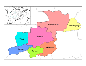
- Detailed Information of Ghor Province
- Current Map of the Districts of Ghor
- ChaghcharanChaghcharan DistrictChaghcharan District is one of the most populated districts in Ghor Province . It is a mountainous district. The winter is severe and the roads are inaccessible because of the snow. The district center Chaghcharan is also the capital of the province. It is situated at at 2268 m elevation. The...
- CharsadaCharsada, AfghanistanCharsada District is a district of Ghor Province, Afghanistan. It was created from the northwestern part of Chaghcharan District. The district center is Qale-Zobayd. The population is 23,000....
- formerly part of Chaghcharan District - Dawlat YarDawlat Yar DistrictDawlat Yar is a district in Ghor Province, Afghanistan. It was created in 2005 from the southeastern part of Chaghcharan District. The administrative center of the district is Delak, but the largest town is Dawlat Yar at 2503 m altitude....
- formerly part of Chaghcharan District - Du LaynaDu Layna DistrictDu Layna is a district in Ghor Province, Afghanistan. It was created from part of the much larger Chaghcharan District. The district population is 30,700....
- formerly part of Chaghcharan District - Lal Wa SarjangalLal Wa Sarjangal DistrictLal Wa Sarjangal is a district in the north of Ghor Province, Afghanistan. The district center is the town of Lal Wa Sarjangal. The population of 95,300 is exclusively Hazara....
- PasabandPasaband DistrictPasaband District is located in the southern part of Ghor Province, Afghanistan. The population is 80,700 . The district center is Shinkot.Pasaband is a mountainous district and the winters are long and severe. Roads are not in good condition and some villages are accessible only using animals...
- SagharSaghar DistrictSaghar District is situated in the most southwestern part of Ghor Province, Afghanistan with district center Titan . The population is 29,500 people. The district, as the other mountainous districts in the province, suffers long and severe winters and continuing drought during the...
- ShahrakShahrak DistrictShahrak District is located in the central part of Ghor Province, Afghanistan. The population is 50,900. The district center is Dahan-e Falezak .-Architecture:Near the village of Jam stands the Minaret of Jam, a historic building....
- TaywaraTaywara DistrictTaywara district is located in the southern part of Ghor Province in Afghanistan. The population is 77,800 people. The district center is the town of Taywara.The district is mountainous and in the winter the roads are often inaccessible.-References:...
- TulakTulak DistrictTulak District is located in the southwestern part of the Ghor Province, Afghanistan. It is a mountainous district like the whole province. The population is 43,800 and the district center is Kwajaha.-References:...
- Chaghcharan
Herat ProvinceHerat ProvinceHerat is one the 34 provinces of Afghanistan; together with Badghis, Farah, and Ghor provinces, it makes up the South-western region of the country...

- Detailed Information of Herat Province
- Current Map of the Districts of Herat
- AdraskanAdraskan DistrictAdraskan is a district in the central part of Herat Province in Afghanistan. It is bordered to the west by Iran, to the north by Ghoryan District, Zinda Jan District, Guzara District, Pashtun Zarghun District and Obe District, to the east by Farsi District and to the south by Shindand District.The...
- Chishti SharifChishti sharif DistrictChishti Sharif District is the most easterly district in Herat Province, Afghanistan, situated along the Hari River and one of its northern tributaries. It borders with Obe District to the west, Badghis Province to the north and Ghor Province to the east and south. The population was estimated at...
- FarsiFarsi DistrictFarsi is a district the west of Herat Province, Afghanistan. It borders on Obe District to the north, Adraskan District to the west, Shindand District to the south and Ghor Province to the south and east. The population was estimated at 26,100 in 2005. The district center is the village of Farsi.-...
- Ghoryan
- GulranGulran DistrictGulran District is situated in northwestern part of Herat province, Afghanistan and borders Iran to the west, Turkmenistan to the north, Kushk District to the east, and Zinda Jan District and Kohsan District to the south. The population is 106,983 . The district center is the village of Gulran....
- GuzaraGuzara DistrictGuzara District is situated in the center of Herat Province, Afghanistan, 10 km south of Herat. It borders Injil District to the north, Pashtun Zarghun District to the east, Adraskan District to the south and Zinda Jan District to the west. The population is 124,900 . The district center Guzara ...
- Hirat
- InjilInjil DistrictInjil is a district of Herat Province in northwestern Afghanistan. It surrounds Herat City and borders Kushk District to the north, Karukh District to the east, Guzara District to the south, and Zinda Jan District to the west...
- KarukhKarukh DistrictKarukh District is situated in the northeastern part of Herat Province, Afghanistan. It borders Kushk District to the northwest, Kushki Kuhna District to the north and Badghis Province to the northeast. To the east is Obe District. To the south is Pashtun Zarghun District and Injil District is...
- KohsanKohsan DistrictKohsan is a district of Herat province in northwestern Afghanistan. It borders the nation of Iran to the west, Gulran District to the north, and Ghurian District to the south and east. The population of Kosan District is 30,100 , which includes the following ethnic groups: 59.4% Pashtun, 35.3%...
- KushkKushk DistrictKushk District is situated in the northern part of Herat Province, Afghanistan and may also may be referred to as Rubat-i-Sangin or Rabat-e-Sangi. It borders Turkmenistan to the north, Gulran District to the west, Zinda Jan District, Injil District and Karukh District to the south and Kushki Kuhna...
- Kushki KuhnaKushki Kuhna DistrictKushki Kuhna is a district of Herat province in northwestern Afghanistan. It is situated in the northern part of the province. It borders Kushk District to the west, the nation of Turkmenistan to the north, Badghis Province to the east, and Karukh District to the south...
- ObeObe DistrictObe is a district in the northeast of Herat Province, Afghanistan. It borders on the north with Badghis Province, on the east with Chishti sharif District, on the southeast with Farsi District, on the south with Adraskan District, and on the west with Pashtun Zarghun and Karukh districts.The...
- Pashtun ZarghunPashtun Zarghun DistrictPashtun Zarghun District , formerly known as Posht-e Zirghān or Posht-e Zirghūn , is situated in the central part of Herat Province, Afghanistan in the valley of the Hari River...
- ShindandShindand DistrictShindand , is one of the 16 districts of Herat Province, in western Afghanistan, and is situated in the southern part of that province. It borders Adraskan District to the north, Ghor Province to the east and Farah Province to the south and west. The population was 151,900 . The district center is...
- Zinda Jan
- Adraskan
Ghazni ProvinceGhazni ProvinceGhazni is one of the thirty-four provinces of Afghanistan. Babur records in his Babur-Nama that Ghazni is also known as Zabulistan It is in the east of the country. Its capital is Ghazni City...
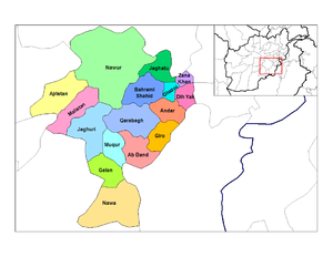
- Detailed Information of Ghazni Province
- Current Map of the Districts of Ghazni
- Ab BandAb Band DistrictAb Band is a district in Ghazni Province, Afghanistan. Its population, which is almost entirely Pashtun, was estimated at 41,340 in 2002. Ab Band is on the main road from Kabul to Kandahar....
- AjristanAjristan DistrictAjristan is a district in the west of Ghazni Province, Afghanistan. Its population was estimated at 62,028 in 2001, of whom 97% were Pashtun with a small number of Hazara. The district capital is Sangar located in the center of the district. Most of the population lives in the valley of the Jikhai...
- AndarAndar DistrictAndar is one of the eastern districts of Ghazni Province in Afghanistan. The population has been estimated at 106,000, all Pashtun. The district center is Miray....
- Dih YakDih Yak DistrictDih Yak is a district in the eastern part of Ghazni Province, Afghanistan, 30 km east from Ghazni. Its population is more than 41,000 . The district center is Ramak....
- GelanGelan DistrictGelan is a district in the south of Ghazni Province, Afghanistan. Its population, which is 100% Pashtun, was estimated at 78,408 in 2002. The district capital is Janda.-References:* , accessed 2006-04-25 .-External links:*...
- Ghazni CityGhazni City DistrictGhazni District is a district of Ghazni Province, Afghanistan situated in the northeaster part of the province. Capital of the district is Ghazni, which is also capital of Ghazni Province.-Demographics & Population:...
- Giro
- Jeghatoo (Waeez Shahid)Jeghatoo DistrictJeghatoo District also Jaghatu District is one of the largest and most populated district in Ghazni Province, west of the city of Ghazni, Afghanistan....
- JaghuriJaghori DistrictJaghori is a major business center and one of the main districts of Ghazni province in Afghanistan. It is situated in the highlands of the central region. The population was estimated at 192,216 in 2002, making it one of the most populous districts in Afghanistan. Sange-e-Masha is a small bazaar...
- KhugianiKhugiani DistrictKhugiani is a district in Ghazni Province, Afghanistan. It was previously part of Jaghatu District. Its territory had been enlarged during the Taliban regime and after then the district was returned to its original borders...
- created from parts of Waeez Shahid and Ghazni Districts - Khwaja UmariKhwaja Umari DistrictKhwaja Umari is a district in Ghazni Province, Afghanistan. It was created in 2005 from the large Bahrami Shahid District. The population in 2005 was estimated at 16,100, of whom 20% were Pashtun, 35% Tajik and 45% Hazara. The district center is the village of Khwaja Umari.The drought is less...
- formerly part of Waeez Shahid District - MalistanMalistan DistrictMalistan is a district in the west of Ghazni Province, Afghanistan. Its population, which is 100% Hazara, was estimated at 71,784 in 2003. The district capital is Meradina.-History:...
- MuqurMuqur District, GhazniMuqur is a district in the southwest of Ghazni Province, Afghanistan. Its population, which is mostly Pashtun along with a few Hazara and Tajik, was estimated at 70,900 in 2002, of whom around 20,000 were children under 12.-References:...
- NawaNawa DistrictNawa is a large district in the far south of Ghazni Province, Afghanistan. It is situated 100 km south from Ghazni in a mountainous region. Its population, which is 100% Pashtun, was estimated at 29,054 in 2002, of whom around 45% were children under 12. The district center is the village of...
- NawurNawur DistrictNawur is the largest district in Ghazni Province, Afghanistan. Its population, which is entirely Hazara, was estimated at 91,778 in 2002. The Jikhai River originates here.-References:...
- QarabaghQarabagh District, GhazniQarabagh district is located 56 km to the south west of Ghazni in eastern Afghanistan. The 1,800 km² area is one of the most populated at 109,000; some reports count more than 200,000...
- RashidanRashidan DistrictRashidan District is a new district in Afghanistan; it was created from the larger Jaghatu district.-Demographics:29,000 people are living in the villages of the district. 96% of them are Pashtun and 4% Hazara.-Water shortage:...
- formerly part of Waeez Shahid District - WaghazWaghaz DistrictWaghaz is a district in Ghazni Province, Afghanistan. It was formed in 2005 from part of Muqur District, and has a population estimated at 32,000. The district center is the town of Waghaz at ....
- formerly part of Muqur District - Zana KhanZana Khan DistrictZana Khan district is a mountainous district in Ghazni Province, Afghanistan with more than 12,000 people living there . The district center is Dado....
- Ab Band
Khost ProvinceKhost ProvinceKhost is one of the thirty-four provinces of Afghanistan. It is in the east of the country. Khost province used to be part of Paktia province in the past...

- Detailed Information of Khost Province
- Current Map of the Districts of Khost
- BakBak DistrictBäk District is situated in the northern part of Khost Province, Afghanistan. It borders Sabari District to the west, Paktia Province and Jaji Maydan District to the north, Pakistan to the east and Tere Zayi District to the south. The population is 19,600 . The district center is the village of...
- GurbuzGurbuz DistrictGurbuz District is situated in the southern part of Khost Province, Afghanistan. It borders Tani District to the west, Mando Zayi and Khost districts to the north and Pakistan to the east and south. The population is 23,200 . The district center is the village of Sekhamir Kalay situated in the...
- Jaji MaydanJaji Maydan DistrictJaji Maydan District is located in the northeastern part of Khost Province, Afghanistan. It borders Bak District to the west, Paktia Province to the north and Pakistan to the north and east. The population is 21,400 . The district center is the village of Jaji Maydan, situated in the eastern part...
- Khost (Matun)Khost (Matun) DistrictKhost District is situated in the central and eastern part of Khost Province, Afghanistan. The district center is the town of Khost. Khost Airfield is situated 2 miles southeast of the town of Khost.-Water:...
- Mandozai
- Musa KhelMusa Khel DistrictMusa Khel District is situated in the northern part of the Khost Province, Afghanistan. It borders with Paktia Province to the north, Sabari District to the east, Khost District to the south, Nadir Shah Kot District to the southwest and Qalandar District to the west. The population is 36,300...
- Nadir Shah KotNadir Shah Kot DistrictNadir Shah Kot District is situated in the western part of Khost Province, Afghanistan. It borders Paktia Province and Shamal District to the west, Qalandar District to the north, Musa Khel District to the northeast, Khost District to the east, Mando Zayi District to the southeast and Tani and...
- QalandarQalandar DistrictQalandar District is situated in the western part of Khost Province, Afghanistan. It borders Paktia Province to the west, Musa Khel District to the north and east and Nadir Shah Kot District to the south. The population is 9,100 . The district center is the village of Khost Mela .*...
- SabariSabari DistrictSabari District is situated in the northern part of Khost Province, Afghanistan. It borders Musa Khel District to the west, Paktia Province to the north, Bak District to the east and Tere Zayi and Khost districts to the south.The population is 62,800...
- ShamalShamal DistrictShamal District is situated in the western part of Khost Province, Afghanistan. It borders Paktia Province to the west, Nadir Shah Kot District to the east and Spera District to the south. The population is 12,200 . The district center is the village of Shamal, situated in the eastern part of the...
- shifted from Paktia Province - SperaSpera DistrictSpera District is situated in the most southwestern part of Khost Province, Afghanistan. It borders with Paktia Province to the south and west, Shamal District to the north. To the east it borders Nadir Shah Kot and Tani districts and Pakistan. The population is 21,500 people. The district center...
- TaniTani DistrictTani District is situated in the southern part of Khost Province, Afghanistan. It borders Spera District to the west, Nadir Shah Kot and Mando Zayi to the north, Gurbuz District to the east and Pakistan to the south. The population is 52,800 people. The district center is the village of Tani,...
- Tere ZayiTere Zayi DistrictTere Zayi is one of the districts of Khost Province, Afghanistan. It is situated in the northeast of the province. It borders with Khost and Sabari districts to the west, Bak District to the north and Pakistan to the east. The population is 39,600. The district center is Aliser, located in the...
- Bak
Paktia ProvincePaktia ProvincePaktia , is one of the thirty-four provinces of Afghanistan, in the east of the country. Its capital is Gardez. The population is predominantly Pashtun.- History:...
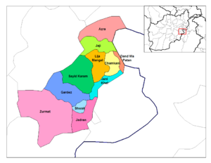
- Detailed Information of Paktia Province
- Current Map of the Districts of Paktia
- AhmadabadAhmadabad DistrictAhmadabad is a district in Paktia Province, Afghanistan. It is located to the east of Gardez, the provincial capital of Paktia.-Security and Politics:...
- formerly part of Sayed Karam District - Chamkani
- Dand Wa PatanDand Wa Patan DistrictDand Wa Patan is a district of Paktia Province, Afghanistan, which borders the Kurram tribal region of Pakistan.-Security and Politics:On 19 August 2009 the Taliban attacked a border police check-post, killing one policeman....
- GardezGardez DistrictGardez is a district in Paktia Province, Afghanistan. The center of the district which is also the capital of Paktia Province is Gardēz.-Demographics & population:Like in the rest of Afghanistan, no exact population numbers are available...
- JajiJaji DistrictJaji is a district in Paktia Province, Afghanistan.-Demographics & population:Like in the rest of Afghanistan, no exact population numbers are available. The Afghan Ministry of Rural Rehabilitation & Development along with UNHCR and Central Statistics Office of Afghanistan estimated the...
- Jani KhailJani Khail DistrictJani Khail is a district in Paktia Province, Afghanistan.-Demographics & population:Like in the rest of Afghanistan, no exact population numbers are available. The Afghan Ministry of Rural Rehabilitation & Development along with UNHCR and Central Statistics Office of Afghanistan estimated the...
- Lazha Ahmad KhelLazha Ahmad Khel DistrictLazha Ahmad Khel District is a district of Paktia Province, Afghanistan....
- Sayed KaramSayed Karam DistrictSayed Karam is a district in Paktia Province, Afghanistan.-Demographics & population:Like in the rest of Afghanistan, no exact population numbers are available. The Afghan Ministry of Rural Rehabilitation & Development along with UNHCR and Central Statistics Office of Afghanistan estimated the...
- ShwakShwak DistrictShwak District is a district of Paktia Province, Afghanistan....
- Wuza ZadranZadran DistrictZadran District is a district of Paktia Province, Afghanistan. The soccer player Djelaludin Sharityar was born in Zadran....
- ZurmatZurmat DistrictZurmat is a district in Paktia Province, Afghanistan.-Demographics & population:Like in the rest of Afghanistan, no exact population numbers are available...
- Ahmadabad
Paktika ProvincePaktika ProvincePaktika is one of the 34 provinces of Afghanistan. It is in the south-east of the country. Most of the population is Pashtun. Its capital is Sharan.-Political and military situation:...
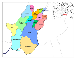
- Detailed Information of Paktika Province
- Current Map of the Districts of Paktika
- BarmalBarmal DistrictBarmal District is a district of Paktika Province, Afghanistan,near the border with North Waziristan, one of Pakistan's Federally Administered Tribal Areas.According to Syed Saleem Shahzad...
- DilaDila District, AfghanistanDila District is a district of Paktika Province, Afghanistan.All information is as of 2007.It has a population of approximately 20000 Afghans and an area of approximately 600 km2. The seat of the district capital is Dila village, with a couple of hundred families. There are a number of...
- GayanGayan DistrictGayan District is a district of Paktika Province, Afghanistan....
- GomalGomal DistrictGomal District is a district of Paktika Province, Afghanistan.It is named after the Gomal River....
- Jani KhelJani Khel DistrictJani Khel is a district in Paktika Province, in eastern Afghanistan. It was created in 2004 out of part of Zarghun Shahr District.-Demographics & population:Like in the rest of Afghanistan, no exact population numbers are available...
- formerly part of Zarghun Shahr District - Mata KhanMata Khan DistrictMata Khan District is a district of Paktika Province, Afghanistan....
- NikaNika DistrictNika District, also known as Naka, is one of the most remote districts in Paktika Province, Afghanistan. It lies in a bowl-shaped valley and is only accessible by a few rocky river beds and a single dirt road, the latter of which is not passable in winter. The valley's economy is rudimentary and...
- OmnaOmna DistrictOmna District is a district of Paktika Province, Afghanistan....
- Sar HawzaSar Hawza DistrictSari-roza or Sar Hawza is a district of Paktika Province, Afghanistan.- Overview :Sarouza is one of the main districts of Paktika.Sar Hawza and Urgun District are strongholds of the Kharoti tribe....
- Sarobi
- SharanSharan DistrictSharan District is home to the city of Sharan, which is the capital of Paktika Province, Afghanistan. The Paktika Governor's compound is in Sharana, attached to the police headquarters for the province.-City of Sharana:...
- Terwa - formerly part of Waza Khwa District
- UrgunUrgun DistrictUrgun is a district of the remote Paktika Province in Afghanistan.-Administrative seat:The administrative seat of this district is the like-named town/village of Urgun, also known as Urgun-e Kalan, meaning "Greater Urgun".-History:...
- Waza KhwaWaza Khwa DistrictWaza Khwa District is a district of Paktika Province, Afghanistan....
- Wor MamayWor Mamay DistrictWor Mamay District is a district of Paktika Province, Afghanistan....
- Yahya KhelYahya Khel DistrictYahya Khel District is a district of Paktika Province, Afghanistan....
- formerly part of Zarghun Shahr District - Yosuf KhelYosuf Khel DistrictYosuf Khel District is a district of Paktika Province, Afghanistan....
- formerly part of Zarghun Shahr District - Zarghun ShahrZarghun Shahr DistrictZarghun Shahr District is a district of Paktika Province, Afghanistan., the district had an estimated population of over 75,000. However, by June 2004 the post-Taliban government separated off three new districts from the large Zarghun Shahr District...
- ZirukZiruk DistrictZiruk District is a district of Paktika Province, once was a part of Paktia, Afghanistan....
- Barmal
Daykundi Province
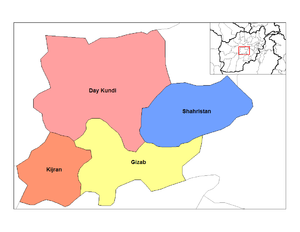
- Detailed Information of Daykundi Province
- Current Map of the Districts of Daykundi
- GizabGizab District'Gizab is a district in Orūzgān Province, Afghanistan. The district lies along the inexact line dividing Afghanistan's Pashtun tribes in the south from the Hazaras in the country's center—Gizab has a mix of Pashtun and Hazara villages. Gizab was transferred in 2004 from Oruzgan province to...
- shifted from Oruzgan Province - IshtarlayIshtarlay DistrictIshtarlay is a district in Daykundi Province, Afghanistan. It was created in 2005 from Daykundi district....
- created within the former Daykundi District; shifted from Oruzgan Province - KajranKajran DistrictKajran, formerly known as Kijran, is a district in Daykundi Province, Afghanistan. It was transferred in 2004 from Uruzgan province. Its population is about 39,000 people. The capital Kajran is at 1346 m altitude....
- shifted from Oruzgan Province - KhadirKhadir DistrictKhadir is a district in Daykundi Province, Afghanistan. It was created in 2005 from Daykundi district. Its capital Khadir is situated at 2,466 m altitude....
- created within the former Daykundi District; shifted from Oruzgan Province - KitiKiti DistrictKiti is a district in Daykundi Province, Afghanistan. It was created in 2005 from the former Kijran district.The main village Kiti is at 1,783 m altitude....
- formerly part of Kajran District; shifted from Oruzgan Province - MiramorMiramor DistrictMiramor is a district in Daykundi Province, Afghanistan. It was created in 2005 from Shahristan district....
- formerly part of Sharistan District; shifted from Oruzgan Province - NiliNili DistrictNili is a district in Daykundi Province, Afghanistan. The main town in the district, also called Nili is the capital of Daykundi Province. The town of Nili is at 2,022 m altitude and has a small airport with a gravel runway and a commercial radio station...
- created within the former Daykundi District; shifted from Oruzgan Province - SangtakhtSangi Takht DistrictSangi Takht is a district in Daykundi Province , Afghanistan. It was created in 2005 from Daykundi district....
- created within the former Daykundi District; shifted from Oruzgan Province - ShahristanShahristan DistrictShahristan is a district in Daykundi Province, Afghanistan. Daykundi var established as a province in the distant north area in Uruzgan province in 2004,...
- shifted from Oruzgan Province
- Gizab
Helmand ProvinceHelmand ProvinceHelmand is one of the 34 provinces of Afghanistan. It is in the southwest of the country. Its capital is Lashkar Gah. The Helmand River flows through the mainly desert region, providing water for irrigation....

- Detailed Information of Helmand Province
- Current Map of the Districts of Helmand
- BaghranBaghran DistrictBaghran is the northernmost district in Helmand Province, Afghanistan. Its population, which is 90% Pashtun and 10% Hazara, was estimated at 82,018 in 2002...
- DishuDishu DistrictDishu is a district in the south of Helmand Province, Afghanistan, bordering Pakistan. Its population, which is 58% Pashtun and 42% Baloch, was estimated at 20,600 in 2002. The district centre is the village of Dishu; most of the settlements in the district are along the Helmand River.-References:*...
- GarmsirGarmsir DistrictGarmsir District is located in the southern part of Helmand Province, Afghanistan. The district is large, but all the villages are along the Helmand River. The rest is a desert. The district capital - Garmsir is located in the northwestern part of the district on the east bank of Helmand River. The...
- GerishkGerishk DistrictGereshk District , also called Nahri Saraj, takes the name from its principal municipality of Gereshk town in Helmand Province, Southern Afghanistan.-Demography:The ethnic composition is predominantly Pashtun....
- KajakiKajaki DistrictKajaki is a district in the east of Helmand Province, Afghanistan. Its population is by a vast majority Pashtun, and stood at 60,700 in 2005. The district centre is the village of Kajaki.-References:* , dated 2002-12-31, accessed 2006-08-03 ....
- KhanashinKhanashin DistrictReg District is situated in the southeastern part of Helmand Province, Afghanistan along the Helmand River on its western bank. The population is 22,400 . The main village is Khanashin....
- LashkargahLashkargah DistrictLashkar Gah is a district in the east of Helmand Province, Afghanistan, surrounding the provincial capital of Lashkar Gah. Its population is 45% Pashtun and 20% Baluch, with ca. 30% Tajiks, 5% are Hindus and Hazara; the population was estimated at 85,800 in 2005...
- Musa QalaMusa Qala DistrictMusa Qala is a district in the north of Helmand Province, Afghanistan.Its population, which is 97% Pashtun, was 50,300 in 2005. The district centre is the village of Musa Qala; there are 19 other large villages and 200 smaller settlements, mostly along the Musa Qala River.In an effort to shoot at...
- Nad AliNad Ali District-References:* , dated 2002-12-31, accessed 2006-08-03 .-External links:*...
- Nawa-I-BarakzayiNawa-I-Barakzayi DistrictNāwa-I-Barakzāyi District is an administrative district in Helmand Province, Afghanistan located south of the provincial capital of Lashkar Gah along the Helmand River. It is bordered by the districts of Lashkar Gah, Nad Ali, Garmsir, and Rig, as well as the provinces of Nimruz and Kandahar...
- NawzadNawzad DistrictNawzad is a district in the north of Helmand Province, Afghanistan. Its population, which is 100% Pashtun, was estimated at 51,170 in 2002. The district centre is the village of Nawzad; there are 14 other large villages and over 100 smaller settlements....
- SanginSangin DistrictSangin is a district in the east of Helmand Province, Afghanistan. Its population, which is 100% Pashtun, was 50,900 in 2005. The district centre is the town of Sangin.-References:* , dated 2002-12-01, accessed 2006-08-04 .-External links:*...
- WashirWashir DistrictWashir is a district in the west of Helmand Province, Afghanistan. Its population, which is 100% Pashtun and Noorzai tribe, was 13,300 in 2005...
- Baghran
Kandahar ProvinceKandahar ProvinceKandahar or Qandahar is one of the largest of the thirty-four provinces of Afghanistan. It is located in southern Afghanistan, between Helmand, Oruzgan and Zabul provinces. Its capital is the city of Kandahar, which is located on the Arghandab River. The province has a population of nearly...

- Detailed Information of Kandahar Province
- Current Map of the Districts of Kandahar
- ArghandabArghandab DistrictArghandab is a district in the central part of Kandahar Province, Afghanistan. It borders Panjwai and Khakrez districts to the west, Shah Wali Kot District to the north and east and Kandahar District to the east and south....
- ArghistanArghistan DistrictThe Arghistan District is a district situated in the northeastern part of Kandahar Province, Afghanistan. It borders Spin Boldak District to the south and west, Daman District to the west, Zabul Province to the north, Maruf District to the east and Pakistan to the east and south. The population is...
- DamanDaman District, AfghanistanDaman district is situated in the central part of the Kandahar Province, Afghanistan. It borders Panjwai and Kandahar districts to the west, Shah Wali Kot District to the north, Zabul Province to the northeast, Arghistan and Spin Boldak districts to the east and Reg District to the south. The...
- GhorakGhorak DistrictGhorak district is situated in the northwestern part of Kandahar Province, Afghanistan. It borders Helmand Province to the West, Oruzgan Province and Naish District to the North, Khakrez District to the East and Maywand District to the South. The population is 8,600 . The district center is the...
- KandaharKandahar DistrictKandahar District is situated in the central part of Kandahar Province, Afghanistan, surrounding the city of Kandahar. It borders with Panjwai District to the west, Arghandab District to the north, Shah Wali Kot District to the northeast and Daman District to the east and south. The population is...
- KhakrezKhakrez DistrictKhakrez District is situated in the northern part of Kandahar Province, Afghanistan. It borders Ghorak District to the west, Maywand and Panjwai districts to the south, Arghandab and Shah Wali Kot districts to the east and Naish District to the north. The population is 20,200...
- MarufMaruf DistrictMaruf District is a district in Kandahar Province, Afghanistan. It borders Arghistan District to the west, Zabul Province to the north and Pakistan to the east and south. The population is 29,300 . The district center is the town of Maruf, located in the northern part of the district...
- MaywandMaywand DistrictMaiwand District is situated in the western part of the Kandahar Province, Afghanistan. It borders Helmand Province to the west, Ghorak District to the north, Khakrez District to the northeast, Zhari District to the east, and Panjwai District to the south. The population is 51,900 . The district...
- Miyan NasheenMiyannasheen DistrictMiyannasheen District is a new district of Kandahar District, Afghanistan, created in 2005. It was formerly in the northern part of Shah Wali Kot District. The population is 13,400 ....
- formerly part of Shah Wali Kot District - NaishNaish DistrictNaish is a mountainous district in the northern part of Kandahar Province, shifted from Oruzgan Province, Afghanistan. It borders Oruzgan Province to the west, north and east and Shah Wali Kot, Khakrez and Ghorak districts to the south. The population is 11,800 . The district center is the village...
- shifted from Oruzgan Province - PanjwayePanjwaye DistrictPanjwai is a district in Kandahar Province, Afghanistan. It is known as the birthplace of the Taliban. It is located about west of Kandahar city...
- RegReg District (Kandahar)Reg District is situated in the southern part of Kandahar Province, Afghanistan. It borders Helmand Province to the west, Panjwai and Daman districts to the north, Shorabak District to the east and Pakistan to the south. The population is 7,900...
- Shah Wali KotShah Wali Kot DistrictShah Wali Kot District is situated in the northern part of Kandahar Province, Afghanistan. It borders Khakrez District to the west, Naish District and Oruzgan Province to the north, Zabul Province to the east and Daman and Arghandab districts to the south. The population is 38,400 . The district...
- ShorabakShorabak DistrictShorabak District is a remote district situated in the southeastern part of Kandahar Province, Afghanistan, 110 km south and east of Kandahar. It borders Reg District to the west, Spin Boldak District to the north and Pakistan to the east and south. The population is 10,200 . The district center...
- Spin BoldakSpin Boldak DistrictSpin Boldak is a district in the eastern part of Kandahar Province, Afghanistan. It borders Daman District to the west, Arghistan District to the north, Qilla Abdullah District Pakistan to the east and Shorabak District to the south. The population was estimated at 100,400 in 2006...
- ZhariZhari DistrictZhari is a new district in Kandahar Province, Afghanistan.Alternate spellings include Zheley or Zharey. The district was created from territories taken from Maywand and Panjwai districts...
- created from parts of Maywand and Panjwaye Districts
- Arghandab
Nimruz ProvinceNimruz ProvinceNimruz is one of the thirty-four provinces of Afghanistan, in the south-west of the country on the borders of Iran and Pakistan. The name Nimruz means "mid-day" or "half-day" in Persian. Nimruz covers 41,000 km² and has a population of 149,000...
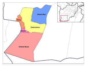
- Detailed Information of Nimruz Province
- Current Map of the Districts of Nimruz
- Chahar BurjakChahar Burjak DistrictChahar Burjak District is a district of Nimruz Province, Afghanistan. At just under 22,000 square kilometers in area, it is the largest district in Afghanistan.-Notable people:...
- ChakhansurChakhansur DistrictChakhansur is a sparsely inhabited district near Nimroz / Zaranj in Nimruz Province in Afghanistan. Its population is approximately 406...
- KangKang DistrictKang District is a district of Nimruz Province, Afghanistan....
- Khash RodKhash Rod DistrictKhash Rod District is a district of Nimruz Province, Afghanistan. Majority of he population is Baluch....
- ZaranjZaranj DistrictZaranj District is a district of Nimruz Province, Afghanistan, containing the provincial capital city of Zaranj.Rourte 606 connects Zaranj to Delaram which helps the Trade, and the toll-customs revenues have grown.-Demographics:...
- Chahar Burjak
Orūzgān ProvinceOruzgan ProvinceOrūzgān or Urōzgān , also spelled Uruzgan or Rōzgān , is one of the thirty-four provinces of Afghanistan. It is in the center of the country, though the area is culturally and tribally linked to Kandahar in the south. Its capital is Tarin Kowt...
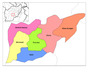
- Detailed Information of Orūzgān Province
- Current Map of the Districts of Orūzgān
- ChoraChora DistrictChora District is a district of Oruzgan Province, Afghanistan. The district center is the town of Chora, with a population of about 3,000. It is a rural town with no industry beyond livestock, agriculture, and small merchants....
- Deh RahwodDeh Rahwod DistrictDeh Rahwod is a district in Oruzgan Province, southern Afghanistan, and the name of the town that serves as district seat. Deh Rahwod lies along the Helmand River...
- Khas UruzganKhas Uruzgan DistrictKhas Uruzgan District is a district of Oruzgan Province, Afghanistan....
- Shahidi HassasShahidi Hassas DistrictShahidi Hassas District is a district of Oruzgan Province, Afghanistan....
- Tarin KowtTarin Kowt DistrictTarin Kowt District is a district of Oruzgan Province, Afghanistan. The capital of the district and the province is the town called Tarin Kowt....
- Chora
Zabul ProvinceZabul ProvinceZabul is a historic province of Afghanistan. Zabul became an independent province from neighbouring Kandahar in 1963, with Qalat being named the provincial capital. It should not be confused with the city Zabol, on the Iranian side of the border with Afghanistan.- Political and security situation...
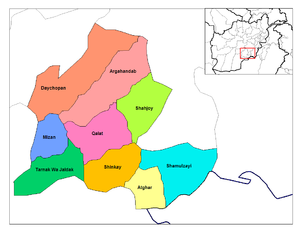
- Detailed Information of Zabul Province
- Current Map of the Districts of Zabul
- ArgahandabArgahandab DistrictArgahandab District is a district of Zabul Province, Afghanistan....
- AtgharAtghar DistrictAtghar District is a district of Zabul Province, Afghanistan....
- Daychopan
- KakarKakar DistrictKakar District is a district of Zabul Province, Afghanistan....
- formerly part of Argahandab District - MizanMizan DistrictMizan District is a district of Zabul Province, Afghanistan....
- Naw BaharNaw Bahar DistrictNaw Bahar District is a district of Zabul Province, Afghanistan....
- created from parts of Shamulzuyi and Shinkay Districts in Zabul Province . - Qalat (Technically only a municipality, not a district)Qalat DistrictQalat District is a district of Zabul Province, Afghanistan. Its district seat is Qalat, the capital of the province....
- Shah Joy
- ShamulzayiShamulzayi DistrictShamulzayi District is a district of Zabul Province, Afghanistan....
- ShinkayShinkay DistrictShinkay District is a district of Zabul Province, Afghanistan....
- Tarnak Wa JaldakTarnak Wa Jaldak DistrictTarnak Wa Jaldak District is a district of Zabul Province, Afghanistan....
- Argahandab