

Discovery District
Encyclopedia
The Discovery District is an area of downtown Toronto
, Ontario
, Canada
, that features a high concentration of hospitals and research institutions, particularly those related to biotechnology
. The district is roughly bounded by Bloor Street
on the north, Bay Street
on the east, Dundas Street
on the south, and Spadina Avenue
on the west.
The neighbourhood includes the campus of the University of Toronto
, as well as leading health-care facilities such as the Hospital for Sick Children
, Toronto General Hospital
, Princess Margaret Hospital
, Mount Sinai Hospital
, Toronto Rehabilitation Institute and the MaRS Discovery District
research facility.
This area was subdivided from 3 main 'park lot' estates: Macaulay Estate (to the east, became a residential district known as 'the Ward' until demolished), Elmsley Estate (redivided with the Macaulay Estate which was concentrated to the south. Elmsley estate is closely tied with the history of both the University of Toronto and the commercial district on Yonge Street) and the Powell Estate (became the 'University Park' now the University of Toronto
)
The situation of these lots just north of the town meant that this land was in high demand as the city outgrew its original boundaries south of Lot (Queen). As most Toronto streets started at Lot (Queen), the 'park lots' commanded impressive views into the town and many of the buildings that were built as the 'park lots' were subdivided by their owner, were impressive institutions such as Osgoode Hall
(Upper Canada's Law Courts) still standing, built at the top of York Street by 1832 just two years before the Town of York became a City with the name Toronto. By the time Toronto became a city in 1834, the area south of Lot St (Queen) from the Garrison Creek to the Don River had all been subdivided and the four 'park lots' north of Lot St (Queen) were subdivided by their owners with the eastern lot (Macaulay's estate) becoming the first residential district north of Queen, the western lot (Powell's estate) becoming the 'University Park', gated parkland intended to become Toronto's University and the area between on the north side of Lot St (Queen) attracting various institutions and businesses.
Development
The area just north of Lot St (Queen) became something of an institutional area with buildings such as the House of Industry (still standing), the Armoury (behind Osgoode Hall, now demolished for the University Avenue Court Houses) and the Eaton's Company store to the south (creating 'the cavern' with the Hudson Bay building on the south of Queen St) and the University of Toronto in the 'University Park' to the north which was gated at Queen St & College Ave (University Ave) and was largely forested. By about 1900 there still remained a large residential district called 'The Ward' which became Toronto's first Chinatown but also attracted many attempts to have it demolished as it was economically depressed. At this time some of Toronto's oldest and most important institutions south of Queen were replaced with larger buildings north of Queen St such as Old City Hall (called 'New' City Hall at this time) at the top of Bay Street and the Ontario Parliament Building; Queen's Park on the University grounds at the top of College Avenue (renamed University Ave).
Grand Plans for a 'Federal District'
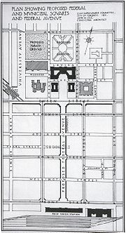 Part of 'The Ward' had been demolished for the building of New City Hall (Now Old City Hall) and in the years after the first world war, several plans were made to more closely link the institutional area north of Queen with the older town to the south. Two plans in particular substantially changed this area although both ultimately collapsed with the Great Depression
. University Avenue was extended south of Queen street although the street itself, formerly a large quiet street leading to Queen's Park and the 'University Park' was only slowly turned into the bustling Boulevard of towers and hospitals it is today, none of the Art Deco towers originally planned for the street were ever built. The second plan called for a new 'Federal Avenue' in the middle of the old town's grid (between Bay and York Streets) starting from the new Union Station north to a proposed Government complex on the north side of Queen. Many buildings in 'The Ward' were purchased by the government before the plan fell through. In the 1960s with the City of Toronto annexing the last independent municipalities, 'The Ward' was demolished and a new City Hall was built on the north side of Queen Street between what became Old City Hall and Osgoode Hall.
Downtown Toronto
Downtown Toronto is the central business district of Toronto, Ontario, Canada. It is approximately bounded by Bloor Street to the north, Lake Ontario to the south, the Don River to the east, and Bathurst Street to the west...
, Ontario
Ontario
Ontario is a province of Canada, located in east-central Canada. It is Canada's most populous province and second largest in total area. It is home to the nation's most populous city, Toronto, and the nation's capital, Ottawa....
, Canada
Canada
Canada is a North American country consisting of ten provinces and three territories. Located in the northern part of the continent, it extends from the Atlantic Ocean in the east to the Pacific Ocean in the west, and northward into the Arctic Ocean...
, that features a high concentration of hospitals and research institutions, particularly those related to biotechnology
Biotechnology
Biotechnology is a field of applied biology that involves the use of living organisms and bioprocesses in engineering, technology, medicine and other fields requiring bioproducts. Biotechnology also utilizes these products for manufacturing purpose...
. The district is roughly bounded by Bloor Street
Bloor Street
Bloor Street is a major east–west residential and commercial thoroughfare in Toronto, in the Canadian province of Ontario. Bloor Street runs from the Prince Edward Viaduct westward into Mississauga, where it ends at Central Parkway. East of the viaduct, Danforth Avenue continues along the same...
on the north, Bay Street
Bay Street
Bay Street, originally known as Bear Street, is a major thoroughfare in Downtown Toronto. It is the centre of Toronto's Financial District and is often used by metonymy to refer to Canada's financial industry since succeeding Montreal's St. James Street in that role in the 1970s...
on the east, Dundas Street
Dundas Street (Toronto)
Dundas Street, also known as Highway 5 west of Toronto, is a major arterial road connecting the centre of that city with its western suburbs and southwestern Ontario beyond...
on the south, and Spadina Avenue
Spadina Avenue
Spadina Avenue is one of the most prominent streets in Toronto, Ontario, Canada. Running through the western section of downtown, the road has a very different character in different neighbourhoods....
on the west.
The neighbourhood includes the campus of the University of Toronto
University of Toronto
The University of Toronto is a public research university in Toronto, Ontario, Canada, situated on the grounds that surround Queen's Park. It was founded by royal charter in 1827 as King's College, the first institution of higher learning in Upper Canada...
, as well as leading health-care facilities such as the Hospital for Sick Children
Hospital for Sick Children
The Hospital for Sick Children – is a major paediatric centre for the Greater Toronto Area, serving patients up to age 18. Located on University Avenue in Downtown Toronto, SickKids is part of the city’s Discovery District, a critical mass of scientists and entrepreneurs who are focused on...
, Toronto General Hospital
Toronto General Hospital
The Toronto General Hospital , is a part of the University Health Network, and a major teaching hospital in downtown Toronto, Ontario. It is located in the Discovery District, directly north of the Hospital for Sick Children, across Gerrard Street West, and east of Princess Margaret Hospital and...
, Princess Margaret Hospital
Princess Margaret Hospital
Princess Margaret Hospital may refer to:* Princess Margaret Hospital in Canada specializing in Oncology* Princess Margaret Hospital * Princess Margaret Hospital in New Zealand...
, Mount Sinai Hospital
Mount Sinai Hospital (Toronto)
Mount Sinai Hospital is a hospital in Toronto, Ontario, Canada. Although it is physically linked by bridges and tunnels to two University Health Network hospitals , Mount Sinai is an independently operated facility...
, Toronto Rehabilitation Institute and the MaRS Discovery District
MaRS Discovery District
MaRS Discovery District is a not-for-profit corporation founded in Toronto in 2000. Its stated goal is to commercialize publicly funded medical research with the help of local private enterprises and as such is a public-private partnership....
research facility.
This area was subdivided from 3 main 'park lot' estates: Macaulay Estate (to the east, became a residential district known as 'the Ward' until demolished), Elmsley Estate (redivided with the Macaulay Estate which was concentrated to the south. Elmsley estate is closely tied with the history of both the University of Toronto and the commercial district on Yonge Street) and the Powell Estate (became the 'University Park' now the University of Toronto
University of Toronto
The University of Toronto is a public research university in Toronto, Ontario, Canada, situated on the grounds that surround Queen's Park. It was founded by royal charter in 1827 as King's College, the first institution of higher learning in Upper Canada...
)
History
The original plans for the Town of York (later City of Toronto) divided the City along Lot Street (Queen Street) with a street grid creating small urban 'town lots' to the south and large rectangular 'park lots' (farms) to the north. The 'park lots' along Lot St (Queen) were given to many of York's (Toronto's) most prominent families who had professions and sometimes even a separate house in the Town and generally did not farm; therefore they often did not clear their lots of the natural forest. As each 'park lot' extended in a rectangle from Lot Street (Queen) to what would become Bloor, most of the estate houses were built on the north side of Lot Street opposite the Town. Four 'park lots' (numbers 9 to 12) comprised the area north of Queen just across from the heart of Toronto between Yonge Street and just west of College Avenue (now University Ave). Three of the families occupying these lots built large estate homes all fairly far north of Lot St (Queen):- Caer Howell (built for the Welsh Loyalist Chief Justice of Upper Canada; William Dummer PowellWilliam Dummer PowellWilliam Dummer Powell was a Loyalist lawyer, judge and political figure in Upper Canada.-Early life and education:...
, later demolished) on College Avenue (now University Avenue). This lot became the 'University Park' (now University of Toronto). - Elmsley Villa (built for another of Upper Canada's Chief Justices and Speaker of the Legislative Assembly; John Elmsley. Was Government House for the short time Toronto was the United Canada'sProvince of CanadaThe Province of Canada, United Province of Canada, or the United Canadas was a British colony in North America from 1841 to 1867. Its formation reflected recommendations made by John Lambton, 1st Earl of Durham in the Report on the Affairs of British North America following the Rebellions of...
capital) this family famously converted to Catholicism and founded St. Michael's CollegeUniversity of St. Michael's CollegeThe University of St. Michael's College is a college of the University of Toronto, founded in 1852 by the Congregation of St. Basil of Annonay, France. While mainly an undergraduate college for liberal arts and sciences, St. Michael's retains its Roman Catholic affiliation through its postgraduate...
on their former 'park lot'. - Teraulay Cottage (named after the owner Mr. & Mrs. Macauley née HayterJames MacaulayJames Macaulay was the Chief Medical Officer of Upper Canada.-Military career:In 1759, was born in Glasgow, Scotland, the son of a clergyman. He gained a commission into the army as a surgeon and served with the Queen's Rangers during the American Revolution. In 1785, he joined the 33rd Regiment...
who had served as surgeon with Simcoe's Queen's Rangers) later subdivided the estate with a square in the centre onto which fronted Terauley Cottage and Little Trinity Anglican Church (still standing) built on land donated by the family. This first Toronto residential neighbourhood north of Lot (Queen) was originally called 'Macauleytown' later 'the Ward'.
The situation of these lots just north of the town meant that this land was in high demand as the city outgrew its original boundaries south of Lot (Queen). As most Toronto streets started at Lot (Queen), the 'park lots' commanded impressive views into the town and many of the buildings that were built as the 'park lots' were subdivided by their owner, were impressive institutions such as Osgoode Hall
Osgoode Hall
Osgoode Hall is a landmark building in downtown Toronto constructed between 1829 and 1832 in the late Georgian Palladian and Neoclassical styles. It houses the Ontario Court of Appeal, the Divisional Court of the Superior Court of Justice, and the Law Society of Upper Canada...
(Upper Canada's Law Courts) still standing, built at the top of York Street by 1832 just two years before the Town of York became a City with the name Toronto. By the time Toronto became a city in 1834, the area south of Lot St (Queen) from the Garrison Creek to the Don River had all been subdivided and the four 'park lots' north of Lot St (Queen) were subdivided by their owners with the eastern lot (Macaulay's estate) becoming the first residential district north of Queen, the western lot (Powell's estate) becoming the 'University Park', gated parkland intended to become Toronto's University and the area between on the north side of Lot St (Queen) attracting various institutions and businesses.
Development
The area just north of Lot St (Queen) became something of an institutional area with buildings such as the House of Industry (still standing), the Armoury (behind Osgoode Hall, now demolished for the University Avenue Court Houses) and the Eaton's Company store to the south (creating 'the cavern' with the Hudson Bay building on the south of Queen St) and the University of Toronto in the 'University Park' to the north which was gated at Queen St & College Ave (University Ave) and was largely forested. By about 1900 there still remained a large residential district called 'The Ward' which became Toronto's first Chinatown but also attracted many attempts to have it demolished as it was economically depressed. At this time some of Toronto's oldest and most important institutions south of Queen were replaced with larger buildings north of Queen St such as Old City Hall (called 'New' City Hall at this time) at the top of Bay Street and the Ontario Parliament Building; Queen's Park on the University grounds at the top of College Avenue (renamed University Ave).
Grand Plans for a 'Federal District'
Great Depression
The Great Depression was a severe worldwide economic depression in the decade preceding World War II. The timing of the Great Depression varied across nations, but in most countries it started in about 1929 and lasted until the late 1930s or early 1940s...
. University Avenue was extended south of Queen street although the street itself, formerly a large quiet street leading to Queen's Park and the 'University Park' was only slowly turned into the bustling Boulevard of towers and hospitals it is today, none of the Art Deco towers originally planned for the street were ever built. The second plan called for a new 'Federal Avenue' in the middle of the old town's grid (between Bay and York Streets) starting from the new Union Station north to a proposed Government complex on the north side of Queen. Many buildings in 'The Ward' were purchased by the government before the plan fell through. In the 1960s with the City of Toronto annexing the last independent municipalities, 'The Ward' was demolished and a new City Hall was built on the north side of Queen Street between what became Old City Hall and Osgoode Hall.