Discovery Bay is:
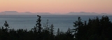
- A small bay adjoining the Strait of Juan de Fuca
The Strait of Juan de Fuca is a large body of water about long that is the Salish Sea outlet to the Pacific Ocean...
on the Olympic PeninsulaThe Olympic Peninsula is the large arm of land in western Washington state of the USA, that lies across Puget Sound from Seattle. It is bounded on the west by the Pacific Ocean, the north by the Strait of Juan de Fuca, and the east by Puget Sound. Cape Alava, the westernmost point in the contiguous...
in Washington State; this body of water was also historically called Port DiscoveryPort Discovery, Washington is the historical name of what is now called Discovery Bay, a bay in the U.S. state of Washington on the south side of the Strait of Juan de Fuca, on Washington's Olympic Peninsula. It was also called Port Discovery Bay for some time, a name that can be found on maps from...
- An unincorporated community
In law, an unincorporated area is a region of land that is not a part of any municipality.To "incorporate" in this context means to form a municipal corporation, a city, town, or village with its own government. An unincorporated community is usually not subject to or taxed by a municipal government...
in Jefferson County, WashingtonJefferson County is a county located in the U.S. state of Washington, named after Thomas Jefferson. As of 2010, the population was 29,872. The county seat is at Port Townsend, which is also the county's only incorporated city....
, United StatesThe United States of America is a federal constitutional republic comprising fifty states and a federal district...
, located along Discovery Bay.
The bay was named by
George VancouverCaptain George Vancouver RN was an English officer of the British Royal Navy, best known for his 1791-95 expedition, which explored and charted North America's northwestern Pacific Coast regions, including the coasts of contemporary Alaska, British Columbia, Washington and Oregon...
after the
Discovery, a ship used in his 1792 expedition of the area. The community at the foot of the bay eventually assumed the same name.
Geography
Discovery Bay is located on the
Olympic PeninsulaThe Olympic Peninsula is the large arm of land in western Washington state of the USA, that lies across Puget Sound from Seattle. It is bounded on the west by the Pacific Ocean, the north by the Strait of Juan de Fuca, and the east by Puget Sound. Cape Alava, the westernmost point in the contiguous...
of Washington State. The bay enters the
Strait of Juan de FucaThe Strait of Juan de Fuca is a large body of water about long that is the Salish Sea outlet to the Pacific Ocean...
between the
MillerThe Miller Peninsula is a small peninsula in Clallam County, Washington and Jefferson County, Washington surrounded by Discovery Bay on the east, the Strait of Juan de Fuca to the north, and Sequim Bay to the west...
and
Quimper PeninsulaThe Quimper Peninsula is a narrow peninsula forming the most northeastern extent of the Olympic Peninsula of Washington state in the northwestern United States of America....
s. The bay's mouth is just south of Protection Island, a small Federally-protected nature preserve. Discovery Bay is 6–7 miles in length, and a bit over a mile wide at its mouth. It is fed by Snow Creek, among other small watercourses.
Communities
The community of Discovery Bay, Washington is an area near the intersection of U.S. Route 101 and State Route 20, at the foot of Discovery Bay – roughly midway between the larger communities of
Port TownsendPort Townsend is a city in Jefferson County, Washington, United States, approximately north-northwest of Seattle . The population was 9,113 at the 2010 census an increase of 9.3% over the 2000 census. It is the county seat and only incorporated city of Jefferson County...
and
SequimSequim is a city in Clallam County, Washington, United States. The 2010 US Census counted a population of 6,606. Sequim is located along the Dungeness River near the base of the Olympic Mountains...
. It is a mix of residential areas and commercial enterprises, including crabbing, oystering, clamming, timbering, security training and gravel extraction. A few restaurants and stores on US 101 near SR 20 primarily serve drivers and truckers along US 101.
Discovery Bay is the current name generally associated with the area. Its use for the community, as opposed to the bay itself, is relatively recent. The original communities in the area, primarily mill towns that waxed and waned along with the local timber industry, had different names:
- Fairmont is a group of residences at the southeast corner of the bay, off SR20 just northeast of US101.
- Discovery Junction is an abandoned railroad junction near Fairmont.
- Uncas is an old mill community to the southwest of Fairmont, on the south side of US101.
- Fort Discovery is the original location of Capt. Vancouvers camp and the current day HQ of Security Services NW.
- Maynard is an old mill community to the north of Uncas, along US 101 at the southwest corner of the bay. A famous abandoned sawmill, just to the east of US101, is a well-known remnant of this community. That mill has often been incorrectly identified as the 1858 Port Discovery Mill (see Port Discovery, below). It was, in fact, the Maynard mill.
These names often appear on maps and persist in local road names. The mill communities no longer have the population or visibility they enjoyed when the mills were operating, making these hamlets primarily matters of local historical interest. However, changing demographics and rising property values are leading to redevelopment of this area, and breathing new life into older names.
South Discovery now constitutes the entirety of the area around Discovery Bay, especially the area between
Port DiscoveryPort Discovery, Washington is the historical name of what is now called Discovery Bay, a bay in the U.S. state of Washington on the south side of the Strait of Juan de Fuca, on Washington's Olympic Peninsula. It was also called Port Discovery Bay for some time, a name that can be found on maps from...
and
Port TownsendPort Townsend is a city in Jefferson County, Washington, United States, approximately north-northwest of Seattle . The population was 9,113 at the 2010 census an increase of 9.3% over the 2000 census. It is the county seat and only incorporated city of Jefferson County...
. The South Discovery voting precinct includes areas away from Discovery Bay, as well.
Several nearby place names are also prominent in Discovery Bay history:
- Eaglemount is an area on the hills to the northeast of Discovery Bay, on the east of SR20 above high bluffs over Discovery Bay. (Eaglemount is sometimes depicted as a location on SR20, but in fact it is reached by turning east on Eaglemount Road from SR20.)
- Port Discovery
Port Discovery, Washington is the historical name of what is now called Discovery Bay, a bay in the U.S. state of Washington on the south side of the Strait of Juan de Fuca, on Washington's Olympic Peninsula. It was also called Port Discovery Bay for some time, a name that can be found on maps from...
is the location of George VancouverCaptain George Vancouver RN was an English officer of the British Royal Navy, best known for his 1791-95 expedition, which explored and charted North America's northwestern Pacific Coast regions, including the coasts of contemporary Alaska, British Columbia, Washington and Oregon...
's 1792 visit to Discovery Bay. Many sources incorrectly identify the current Discovery Bay community as the location of Port Discovery; however, Port Discovery was several miles away, at Mill Point. This is several miles further west along US101, near what today is called Broders Road.. Also see below for historical notes.
There are several other communities located on Discovery Bay. Proceeding clockwise from the northeast corner:
- Port Townsend
Port Townsend is a city in Jefferson County, Washington, United States, approximately north-northwest of Seattle . The population was 9,113 at the 2010 census an increase of 9.3% over the 2000 census. It is the county seat and only incorporated city of Jefferson County...
occupies the northern end of the Quimper PeninsulaThe Quimper Peninsula is a narrow peninsula forming the most northeastern extent of the Olympic Peninsula of Washington state in the northwestern United States of America....
, above the northeast corner of the bay. The downtown area of Port Townsend, a famous seaport (once the major port of the region, before the rise of Seattle), is on the opposite side of the peninsula.
- Cape George
Cape George is an unincorporated community on the Olympic Peninsula in Washington state. It lies along the eastern shore of Discovery Bay on the western coast of the Quimper Peninsula in eastern Jefferson County....
is located on high bluffs at the northeast entrance of the bay.
- Beckett Point
Beckett Point is a small point jutting out into Discovery Bay located ten miles from the city of Port Townsend in Jefferson County, Washington, United States. The Point is owned by the Beckett Point Fisherman's Club, which leases out 96 homes...
is a shoreline community a mile south of Cape George.
- Adelma Beach is a shoreline community halfway down the bay.
- Gardiner
right|450px|Looking north from GardinerGardiner is an unincorporated community in Jefferson County, Washington, United States. Gardiner is located on the Miller Peninsula, at the northern coast of the Olympic Peninsula on Discovery Bay,...
is a community several miles further west along US101, established by Herbert Gardner in the late 19th century. (The town name spelling originally matched that of its founder, but was later changed due to a conflict with another Gardner, Washington.)
- Diamond Point
right|350px|thumb|Diamond Point, seen from GardinerDiamond Point is an unincorporated community in Clallam County, Washington, United States, located on the Miller Peninsula. Located mostly along the waterfront, Diamond Point is entirely residential...
is located at the northwest mouth of the bay, opposite Protection Island. It once hosted a government quarantine station.
History
Native people – the
KlallamKlallam refers to four related indigenous Native American/First Nations communities from the Pacific Northwest of North America. The Klallam culture is classified ethnographically and linguistically in the Coast Salish subgroup...
(locally: S'Klallam) people – have occupied the lands around the
Strait of Juan de FucaThe Strait of Juan de Fuca is a large body of water about long that is the Salish Sea outlet to the Pacific Ocean...
for millennia, including locations on Discovery Bay. Most native populations on the
Olympic PeninsulaThe Olympic Peninsula is the large arm of land in western Washington state of the USA, that lies across Puget Sound from Seattle. It is bounded on the west by the Pacific Ocean, the north by the Strait of Juan de Fuca, and the east by Puget Sound. Cape Alava, the westernmost point in the contiguous...
were relocated to reservations during the 19th and early 20th centuries, leaving only scattered individuals of native descent still residing on the bay.
The Spanish explorers
Manuel QuimperManuel Quimper Benítez del Pino was a Spanish Peruvian explorer, cartographer, naval officer, and colonial official. He participated in charting the Strait of Juan de Fuca and the Sandwich Islands in the late 18th century. He was later appointed a colonial governor in his native Peru at the...
(hence:
Quimper PeninsulaThe Quimper Peninsula is a narrow peninsula forming the most northeastern extent of the Olympic Peninsula of Washington state in the northwestern United States of America....
) and
Gonzalo López de HaroGonzalo López de Haro was a Spanish explorer, notable for his expeditions in the Pacific Northwest in the late 18th century....
in the
Princesa Real are the first known Europeans to find and map the bay of Port Discovery. They were sent to explore the Strait of Juan de Fuca by
Francisco de ElizaFrancisco de Eliza y Reventa was a Spanish naval officer, navigator, and explorer. He is remembered mainly for his work in the Pacific Northwest...
in 1790. The Spanish named the bay
Puerto Quadra, after
Juan Francisco de la Bodega y QuadraJuan Francisco de la Bodega y Quadra was a Spanish naval officer born in Lima, Peru. Assigned to the Pacific coast Spanish Naval Department base at San Blas, in the Viceroyalty of New Spain , this navigator explored the Northwest Coast of North America as far north as present day Alaska.Juan...
.
In 1792,
George VancouverCaptain George Vancouver RN was an English officer of the British Royal Navy, best known for his 1791-95 expedition, which explored and charted North America's northwestern Pacific Coast regions, including the coasts of contemporary Alaska, British Columbia, Washington and Oregon...
's exploration of the area provided names for Discovery Bay and
Port DiscoveryPort Discovery, Washington is the historical name of what is now called Discovery Bay, a bay in the U.S. state of Washington on the south side of the Strait of Juan de Fuca, on Washington's Olympic Peninsula. It was also called Port Discovery Bay for some time, a name that can be found on maps from...
.
In 1858, the S. L. Mastick Company of
San FranciscoSan Francisco , officially the City and County of San Francisco, is the financial, cultural, and transportation center of the San Francisco Bay Area, a region of 7.15 million people which includes San Jose and Oakland...
established the Port Discovery Mill on the western shore of the bay, at what today is called "Mill Point." The old growth timber on the steep hillsides above the mill were felled, slid down to the sawmill, milled into lumber and loaded from the wharf to ships for other ports. A village grew around the mill to house its employees. The peak population of the community, in the late 19th century, was in the hundreds.
Port Discovery, WashingtonPort Discovery, Washington is the historical name of what is now called Discovery Bay, a bay in the U.S. state of Washington on the south side of the Strait of Juan de Fuca, on Washington's Olympic Peninsula. It was also called Port Discovery Bay for some time, a name that can be found on maps from...
remained an important coastal port well into the 20th century, and was visited by many Pacific Ocean vessels.
The
U.S. Federal Census of 1860The United States Census of 1860 was the eighth Census conducted in the United States. It determined the population of the United States to be 31,443,321 — an increase of 35.4 percent over the 23,191,875 persons enumerated during the 1850 Census...
designated Port Discovery as one of three enumeration districts in
Jefferson CountyJefferson County is a county located in the U.S. state of Washington, named after Thomas Jefferson. As of 2010, the population was 29,872. The county seat is at Port Townsend, which is also the county's only incorporated city....
. The
indigenous peopleNative Americans in the United States are the indigenous peoples in North America within the boundaries of the present-day continental United States, parts of Alaska, and the island state of Hawaii. They are composed of numerous, distinct tribes, states, and ethnic groups, many of which survive as...
were not counted for this census. The total population was 70 and all but one were males between the ages of 20 and 52 years old. The one female was married to a cook and the only non-
whiteWhite people is a term which usually refers to human beings characterized, at least in part, by the light pigmentation of their skin...
person counted was an African-American male cook. Two thirds of the population were American-born, all of which had migrated west from other states. Of the third that were foreign born, all but one were from
EnglandEngland is a country that is part of the United Kingdom. It shares land borders with Scotland to the north and Wales to the west; the Irish Sea is to the north west, the Celtic Sea to the south west, with the North Sea to the east and the English Channel to the south separating it from continental...
,
IrelandIreland is an island to the northwest of continental Europe. It is the third-largest island in Europe and the twentieth-largest island on Earth...
,
WalesWales is a country that is part of the United Kingdom and the island of Great Britain, bordered by England to its east and the Atlantic Ocean and Irish Sea to its west. It has a population of three million, and a total area of 20,779 km²...
, or
CanadaCanada is a North American country consisting of ten provinces and three territories. Located in the northern part of the continent, it extends from the Atlantic Ocean in the east to the Pacific Ocean in the west, and northward into the Arctic Ocean...
. The exception was born in
SwedenSweden , officially the Kingdom of Sweden , is a Nordic country on the Scandinavian Peninsula in Northern Europe. Sweden borders with Norway and Finland and is connected to Denmark by a bridge-tunnel across the Öresund....
.
Another major mill community was established at the foot of the bay, where the town of Maynard grew. The Maynard mill continued in operation until the 1970s, and was responsible for the several nearby small communities mentioned above. The abandoned sawmill was a popular sight for tourists, and appears in many nostalgic area photographs and paintings. It deteriorated rapidly during storms in 2005-2006, and as of 2007 had been slated for removal, as part of a habitat restoration effort.
External links