
Demilitarized zone
Encyclopedia

Military
A military is an organization authorized by its greater society to use lethal force, usually including use of weapons, in defending its country by combating actual or perceived threats. The military may have additional functions of use to its greater society, such as advancing a political agenda e.g...
terms, a demilitarized zone (DMZ) is an area, usually the frontier or boundary between two or more military powers (or alliances), where military activity is not permitted, usually by peace treaty
Treaty
A treaty is an express agreement under international law entered into by actors in international law, namely sovereign states and international organizations. A treaty may also be known as an agreement, protocol, covenant, convention or exchange of letters, among other terms...
, armistice
Armistice
An armistice is a situation in a war where the warring parties agree to stop fighting. It is not necessarily the end of a war, but may be just a cessation of hostilities while an attempt is made to negotiate a lasting peace...
, or other bilateral or multilateral agreement. Often the demilitarized zone lies upon a line of control
Line of Control
The term Line of Control refers to the military control line between the Indian- and Pakistani-controlled parts of the former princely state of Jammu and Kashmir—a line which, to this day, does not constitute a legally recognized international boundary but is the de facto border...
and forms a de-facto international border.
Several demilitarized zones have also unintentionally become wildlife preserves, as they cause the land which they sit on to be too dangerous for construction and less exposed to human disturbance or hunting. See Korean Demilitarized Zone
Korean Demilitarized Zone
The Korean Demilitarized Zone is a strip of land running across the Korean Peninsula that serves as a buffer zone between North and South Korea. The DMZ cuts the Korean Peninsula roughly in half, crossing the 38th parallel on an angle, with the west end of the DMZ lying south of the parallel and...
, Vietnamese Demilitarized Zone
Vietnamese Demilitarized Zone
The Vietnamese Demilitarized Zone was established as a dividing line between North and South Vietnam as a result of the First Indochina War.During the Second Indochina War , it became important as the battleground demarcation separating North Vietnamese territory from South Vietnamese territory.-...
, Ben Hai River
Ben Hai River
The Ben Hai River is a river in central Vietnam which became an important landmark in the partition of the country into a northern and a southern zone along the 17th parallel by the Geneva Accords of 1954...
, Hien Luong Bridge
Hien Luong Bridge
Hien Luong Bridge is a bridge over Ben Hai River, Vĩnh Linh District, Quang Tri Province, Bắc Trung Bộ, Việt Nam. This bridge is located in 17th Parallel and in Vietnam War, it was bisected between South Vietnam and North Vietnam....
Generally, "demilitarized" means converted to non-military use or purpose, returned to a demilitarized field. In such meaning the term is often used in former Soviet
Soviet Union
The Soviet Union , officially the Union of Soviet Socialist Republics , was a constitutionally socialist state that existed in Eurasia between 1922 and 1991....
republics both in Western and local (transliterated) languages.
Although many demilitarized zones are also neutral territory
Neutral territory
A neutral territory is a territory that is not an integral part of any state , and yet is not terra nullius, but is the object of an agreement under international law between at least two parties...
, since neither side is allowed to control it even for non combat administration, there are cases where a zone remains demilitarized after an agreement awarding full control to one state, which relinquished the normal right to establish any military forces or installations there.
It is also possible for powers to agree on the demilitarization of a zone without formally settling their still conflicting territorial claims, implying these are only to be pursued by peaceful means (such as diplomatic dialogue or an international court), or even frozen.
Africa
- Between northern MoroccoMoroccoMorocco , officially the Kingdom of Morocco , is a country located in North Africa. It has a population of more than 32 million and an area of 710,850 km², and also primarily administers the disputed region of the Western Sahara...
and the SpanishSpainSpain , officially the Kingdom of Spain languages]] under the European Charter for Regional or Minority Languages. In each of these, Spain's official name is as follows:;;;;;;), is a country and member state of the European Union located in southwestern Europe on the Iberian Peninsula...
cities of CeutaCeutaCeuta is an autonomous city of Spain and an exclave located on the north coast of North Africa surrounded by Morocco. Separated from the Iberian peninsula by the Strait of Gibraltar, Ceuta lies on the border of the Mediterranean Sea and the Atlantic Ocean. Ceuta along with the other Spanish...
and MelillaMelillaMelilla is a autonomous city of Spain and an exclave on the north coast of Morocco. Melilla, along with the Spanish exclave Ceuta, is one of the two Spanish territories located in mainland Africa...
lies a demilitarized zone. Morocco has never recognized Ceuta and Melilla as part of SpainSpainSpain , officially the Kingdom of Spain languages]] under the European Charter for Regional or Minority Languages. In each of these, Spain's official name is as follows:;;;;;;), is a country and member state of the European Union located in southwestern Europe on the Iberian Peninsula...
.
See: Ceuta border fence
Ceuta border fence
The Ceuta border fence is a separation barrier between Morocco and Spain at Ceuta, a city in the North African coast. Constructed by Spain, its purpose is to stop illegal immigration and smuggling....
and Melilla border fence
Melilla border fence
The Melilla border fence is a separation barrier between Morocco and the Spanish city of Melilla. Constructed by Spain, its stated purpose is to stop illegal immigration and smuggling.-Recent history:...
.
Antarctica
Article 1 of the main Antarctic TreatyAntarctic Treaty System
The Antarctic Treaty and related agreements, collectively called the Antarctic Treaty System or ATS, regulate international relations with respect to Antarctica, Earth's only continent without a native human population. For the purposes of the treaty system, Antarctica is defined as all of the land...
forbids military activity in Antarctica, though military personnel and equipment may use the landmass for peaceful purposes.
Asia
- The Korean Demilitarized ZoneKorean Demilitarized ZoneThe Korean Demilitarized Zone is a strip of land running across the Korean Peninsula that serves as a buffer zone between North and South Korea. The DMZ cuts the Korean Peninsula roughly in half, crossing the 38th parallel on an angle, with the west end of the DMZ lying south of the parallel and...
separates North KoreaNorth KoreaThe Democratic People’s Republic of Korea , , is a country in East Asia, occupying the northern half of the Korean Peninsula. Its capital and largest city is Pyongyang. The Korean Demilitarized Zone serves as the buffer zone between North Korea and South Korea...
and South KoreaSouth KoreaThe Republic of Korea , , is a sovereign state in East Asia, located on the southern portion of the Korean Peninsula. It is neighbored by the People's Republic of China to the west, Japan to the east, North Korea to the north, and the East China Sea and Republic of China to the south...
. It was created as part of the Korean Armistice Agreement between North Korean, People's Republic of China, and United Nations Command forces in 1953 ending the Korean WarKorean WarThe Korean War was a conventional war between South Korea, supported by the United Nations, and North Korea, supported by the People's Republic of China , with military material aid from the Soviet Union...
. - Cambodian–Thai border dispute near the Preah Vihear Temple
- Kuwait-Iraq barrier
- The Sinai PeninsulaSinai PeninsulaThe Sinai Peninsula or Sinai is a triangular peninsula in Egypt about in area. It is situated between the Mediterranean Sea to the north, and the Red Sea to the south, and is the only part of Egyptian territory located in Asia as opposed to Africa, effectively serving as a land bridge between two...
. The Camp David AccordsCamp David AccordsThe Camp David Accords were signed by Egyptian President Anwar El Sadat and Israeli Prime Minister Menachem Begin on September 17, 1978, following thirteen days of secret negotiations at Camp David. The two framework agreements were signed at the White House, and were witnessed by United States...
set a limit to the amount of forces EgyptEgyptEgypt , officially the Arab Republic of Egypt, Arabic: , is a country mainly in North Africa, with the Sinai Peninsula forming a land bridge in Southwest Asia. Egypt is thus a transcontinental country, and a major power in Africa, the Mediterranean Basin, the Middle East and the Muslim world...
could place in the Sinai Peninsula. Different zones of the peninsula are demilitarized to different degrees, especially within 20-40 kilometers from Israel. Israel also agreed to limit its forces 3 kilometers from the Egyptian border. - UNDOF Zone between Golan Heights and SyriaSyriaSyria , officially the Syrian Arab Republic , is a country in Western Asia, bordering Lebanon and the Mediterranean Sea to the West, Turkey to the north, Iraq to the east, Jordan to the south, and Israel to the southwest....
Europe
- The United Nations Buffer Zone in CyprusUnited Nations Buffer Zone in CyprusThe United Nations Buffer Zone in Cyprus runs for more than along what is known as the Green Line and has an area of . The zone partitions the island of Cyprus into a southern area effectively controlled by the government of the Republic of Cyprus , and the northern area...
separates the self-proclaimed and internationally unrecognized Turkish Republic of Northern CyprusTurkish Republic of Northern CyprusNorthern Cyprus or North Cyprus , officially the Turkish Republic of Northern Cyprus , is a self-declared state that comprises the northeastern part of the island of Cyprus...
from the Republic of CyprusCyprusCyprus , officially the Republic of Cyprus , is a Eurasian island country, member of the European Union, in the Eastern Mediterranean, east of Greece, south of Turkey, west of Syria and north of Egypt. It is the third largest island in the Mediterranean Sea.The earliest known human activity on the...
. It was created by the United Nations in 1974 after the Turkish invasion of CyprusTurkish invasion of CyprusThe Turkish invasion of Cyprus, launched on 20 July 1974, was a Turkish military invasion in response to a Greek military junta backed coup in Cyprus...
.
- Åland (Ahvenanmaa in FinnishFinnish languageFinnish is the language spoken by the majority of the population in Finland Primarily for use by restaurant menus and by ethnic Finns outside Finland. It is one of the two official languages of Finland and an official minority language in Sweden. In Sweden, both standard Finnish and Meänkieli, a...
) is an autonomousFederacyA federacy is a form of government where one or several substate units enjoy considerably more independence than the majority of the substate units. To some extent, such an arrangement can be considered as similar to asymmetric federalism.-Description:...
islandIslandAn island or isle is any piece of sub-continental land that is surrounded by water. Very small islands such as emergent land features on atolls can be called islets, cays or keys. An island in a river or lake may be called an eyot , or holm...
region on the coast of FinlandFinlandFinland , officially the Republic of Finland, is a Nordic country situated in the Fennoscandian region of Northern Europe. It is bordered by Sweden in the west, Norway in the north and Russia in the east, while Estonia lies to its south across the Gulf of Finland.Around 5.4 million people reside...
(in the Gulf of BothniaGulf of BothniaThe Gulf of Bothnia is the northernmost arm of the Baltic Sea. It is situated between Finland's west coast and Sweden's east coast. In the south of the gulf lie the Åland Islands, between the Sea of Åland and the Archipelago Sea.-Name:...
). It was made a demilitarized zone in 1856 following the Crimean WarCrimean WarThe Crimean War was a conflict fought between the Russian Empire and an alliance of the French Empire, the British Empire, the Ottoman Empire, and the Kingdom of Sardinia. The war was part of a long-running contest between the major European powers for influence over territories of the declining...
. The demilitarized status was later confirmed in 1921 by the League of NationsLeague of NationsThe League of Nations was an intergovernmental organization founded as a result of the Paris Peace Conference that ended the First World War. It was the first permanent international organization whose principal mission was to maintain world peace...
, after the Åland crisisÅland crisisThe Åland crisis was one of the first issues put up for arbitration by the League of Nations on its formation. The Åland Islands' population's demand for self-determination was not met and sovereignty over the islands was retained by Finland, but international guarantees were given to allow the...
from 1920 to 1922.
- TransnistriaJoint Control CommissionThe Joint Control Commission , is a tri-lateral peacekeeping force and joint military command structure which operates in a buffer zone on the border between the Republic of Moldova and the disputed territory controlled by the Pridnestrovian Moldavian Republic .-History:Following the War of...
- tri-lateral peacekeeping mission. The buffer zone is created roughly outlining the Dnister River that lies between MoldovaMoldovaMoldova , officially the Republic of Moldova is a landlocked state in Eastern Europe, located between Romania to the West and Ukraine to the North, East and South. It declared itself an independent state with the same boundaries as the preceding Moldavian Soviet Socialist Republic in 1991, as part...
and the autonomous territory of TransnistriaTransnistriaTransnistria is a breakaway territory located mostly on a strip of land between the Dniester River and the eastern Moldovan border to Ukraine...
. Since 1999, the Russian Federation has failed to remove its military presence from the region.
- A 5 km wide DMZ or GSZ (Ground Safety Zone) under the Military Technical Agreement exists between SerbiaSerbiaSerbia , officially the Republic of Serbia , is a landlocked country located at the crossroads of Central and Southeast Europe, covering the southern part of the Carpathian basin and the central part of the Balkans...
and KosovoKosovoKosovo is a region in southeastern Europe. Part of the Ottoman Empire for more than five centuries, later the Autonomous Province of Kosovo and Metohija within Serbia...
following the Kosovo WarKosovo WarThe term Kosovo War or Kosovo conflict was two sequential, and at times parallel, armed conflicts in Kosovo province, then part of FR Yugoslav Republic of Serbia; from early 1998 to 1999, there was an armed conflict initiated by the ethnic Albanian "Kosovo Liberation Army" , who sought independence...
.
- SvalbardSvalbardSvalbard is an archipelago in the Arctic, constituting the northernmost part of Norway. It is located north of mainland Europe, midway between mainland Norway and the North Pole. The group of islands range from 74° to 81° north latitude , and from 10° to 35° east longitude. Spitsbergen is the...
: The Spitsbergen Treaty of 9 February 1920 recognized NorwegianNorwayNorway , officially the Kingdom of Norway, is a Nordic unitary constitutional monarchy whose territory comprises the western portion of the Scandinavian Peninsula, Jan Mayen, and the Arctic archipelago of Svalbard and Bouvet Island. Norway has a total area of and a population of about 4.9 million...
sovereignty (so it is not a neutral territory), ending the territorial claims of all other signatories, and designated the area as demilitarized.
Famous former demilitarized zones
- A neutral territory was established between the British territory of GibraltarGibraltarGibraltar is a British overseas territory located on the southern end of the Iberian Peninsula at the entrance of the Mediterranean. A peninsula with an area of , it has a northern border with Andalusia, Spain. The Rock of Gibraltar is the major landmark of the region...
and SpainSpainSpain , officially the Kingdom of Spain languages]] under the European Charter for Regional or Minority Languages. In each of these, Spain's official name is as follows:;;;;;;), is a country and member state of the European Union located in southwestern Europe on the Iberian Peninsula...
after the end of the 1727 siegeSiege of Gibraltar (1727)The Siege of Gibraltar of 1727 saw Spanish forces besiege the British garrison of Gibraltar as part of the Anglo-Spanish War. Depending on the sources, Spanish troops were between 12,000 and 25,000. British defenders were 1,500 at the beginning of the siege, increasing up to about 5,000...
. A strip of land 600 toiseToiseA toise is a unit of measure for length, area and volume originating in pre-revolutionary France. In North America, it was used in colonial French establishments in early New France, French Louisiana , and Quebec...
s (around 1.2 km) long, being more than 2 cannon shots distance between the British guns and the Spanish guns was called "the neutral ground" and shown as such on older maps. In 1908 the BritishUnited Kingdom of Great Britain and IrelandThe United Kingdom of Great Britain and Ireland was the formal name of the United Kingdom during the period when what is now the Republic of Ireland formed a part of it....
constructed a fence in a portion claimed to be the British half of the neutral territory. Spain does not recognize that the UK has any right to sovereignty over the isthmus, including the border. (see Disputed status of the isthmus between Gibraltar and SpainDisputed status of the isthmus between Gibraltar and SpainThe Gibraltar territory currently contains an long section of the isthmus that links the Rock with mainland Spain. Spain does not acknowledge British sovereignty over Gibraltar beyond the fortified perimeter of the town as at 1704...
) and asserts it is Spanish soil. Although both the United Kingdom and Spain are part of the European UnionEuropean UnionThe European Union is an economic and political union of 27 independent member states which are located primarily in Europe. The EU traces its origins from the European Coal and Steel Community and the European Economic Community , formed by six countries in 1958...
the border is now a de factoDe factoDe facto is a Latin expression that means "concerning fact." In law, it often means "in practice but not necessarily ordained by law" or "in practice or actuality, but not officially established." It is commonly used in contrast to de jure when referring to matters of law, governance, or...
international frontier with customs and immigration checks. As Spain does not formally recognise it as 'a frontier' it refers to it as 'a fence'. Whatever its name, the crossing remains relevant, as Gibraltar opted out of the European Union Customs UnionEuropean Union Customs UnionThe European Union Customs Union is a customs union which consists of all the Member States of the European Union and a number of surrounding countries....
and is not part of the Schengen areaSchengen AreaThe Schengen Area comprises the territories of twenty-five European countries that have implemented the Schengen Agreement signed in the town of Schengen, Luxembourg, in 1985...
. It is open 24 hours a day with customsCustomsCustoms is an authority or agency in a country responsible for collecting and safeguarding customs duties and for controlling the flow of goods including animals, transports, personal effects and hazardous items in and out of a country...
duties payable on certain goods entering Spain or Gibraltar. - The German RhinelandRhinelandHistorically, the Rhinelands refers to a loosely-defined region embracing the land on either bank of the River Rhine in central Europe....
was made a demilitarized zone after World War I by the Treaty of VersaillesTreaty of VersaillesThe Treaty of Versailles was one of the peace treaties at the end of World War I. It ended the state of war between Germany and the Allied Powers. It was signed on 28 June 1919, exactly five years after the assassination of Archduke Franz Ferdinand. The other Central Powers on the German side of...
in 1919. Rhineland was re-occupied and re-militarizedRemilitarization of the RhinelandThe Remilitarization of the Rhineland by the German Army took place on 7 March 1936 when German military forces entered the Rhineland. This was significant because it violated the terms of the Locarno Treaties and was the first time since the end of World War I that German troops had been in this...
in 1936 by Nazi GermanyNazi GermanyNazi Germany , also known as the Third Reich , but officially called German Reich from 1933 to 1943 and Greater German Reich from 26 June 1943 onward, is the name commonly used to refer to the state of Germany from 1933 to 1945, when it was a totalitarian dictatorship ruled by...
in violation of international treaties. - Saudi-Iraqi neutral zoneSaudi-Iraqi neutral zoneThe Saudi–Iraqi neutral zone was an area of 7,044 km² on the border between Saudi Arabia and Iraq within which the border between the two countries had not been settled...
, originally established in 1922 but disbanded officially since 1991. - Saudi-Kuwaiti neutral zoneSaudi-Kuwaiti neutral zoneThe Saudi–Kuwaiti neutral zone, also known as the Divided Zone, was an area of 5,770 km² between the borders of Saudi Arabia and Kuwait that was left undefined when the border was established by the Uqair Convention of December 2, 1922....
, originally established in 1922 but was disbanded by mutual agreement since 1970. - Israel and Egypt: Following the 1948 Arab-Israeli War1948 Arab-Israeli WarThe 1948 Arab–Israeli War, known to Israelis as the War of Independence or War of Liberation The war commenced after the termination of the British Mandate for Palestine and the creation of an independent Israel at midnight on 14 May 1948 when, following a period of civil war, Arab armies invaded...
, a DMZ, the El Auja ZoneEl Auja ZoneAuja al-Hafir, also Auja, was an ancient road junction close to water wells in the western Negev and eastern Sinai. It was the traditional grazing land of the 'Azazme tribe. The border crossing between Egypt and Ottoman/British Palestine, about 60 km south of Gaza, was situated there...
was created by the 1949 Armistice Agreements1949 Armistice AgreementsThe 1949 Armistice Agreements are a set of agreements signed during 1949 between Israel and neighboring Egypt, Lebanon, Jordan, and Syria. The agreements ended the official hostilities of the 1948 Arab-Israeli War, and established armistice lines between Israeli forces and the forces in...
between Israel and Egypt. - Israel and Jordan, following the 1948 Arab-Israeli War:
- The Israeli enclave and Jordanian area on Mt. Scopus was designated as a DMZ.
- The area around the LatrunLatrunLatrun is a strategic hilltop in the Ayalon Valley in Israel overlooking the road to Jerusalem. It is located 25 kilometers west of Jerusalem and 14 kilometers southeast of Ramla.-Etymology:...
salient.
- Israel and Syria: Following the 1948 Arab-Israeli War, 3 DMZs were created by the 1949 Armistice Agreements1949 Armistice AgreementsThe 1949 Armistice Agreements are a set of agreements signed during 1949 between Israel and neighboring Egypt, Lebanon, Jordan, and Syria. The agreements ended the official hostilities of the 1948 Arab-Israeli War, and established armistice lines between Israeli forces and the forces in...
between Israel and Syria. - China: Japanese forces conquered ManchuriaManchuriaManchuria is a historical name given to a large geographic region in northeast Asia. Depending on the definition of its extent, Manchuria usually falls entirely within the People's Republic of China, or is sometimes divided between China and Russia. The region is commonly referred to as Northeast...
between September 1931 and February 1932, when they proclaimed the region to be the state of ManchukuoManchukuoManchukuo or Manshū-koku was a puppet state in Manchuria and eastern Inner Mongolia, governed under a form of constitutional monarchy. The region was the historical homeland of the Manchus, who founded the Qing Empire in China...
. In May 1933, the Tanggu TruceTanggu TruceThe Tanggu Truce, sometimes called the Tangku Truce , Japanese , was a cease-fire signed between China and Empire of Japan in Tanggu District, Tianjin on May 31, 1933, formally ending the Japanese invasion of Manchuria which had begun two years earlier....
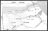
between China and Japan was concluded, which established a demilitarized zone between Manchukuo and China proper. - VietnamVietnamese Demilitarized ZoneThe Vietnamese Demilitarized Zone was established as a dividing line between North and South Vietnam as a result of the First Indochina War.During the Second Indochina War , it became important as the battleground demarcation separating North Vietnamese territory from South Vietnamese territory.-...
: The demilitarized zone between North and South Vietnam was established in April 1954 as a result of the Geneva ConferenceGeneva Conference (1954)The Geneva Conference was a conference which took place in Geneva, Switzerland, whose purpose was to attempt to find a way to unify Korea and discuss the possibility of restoring peace in Indochina...
ending the war between the Viet MinhViet MinhViệt Minh was a national independence coalition formed at Pac Bo on May 19, 1941. The Việt Minh initially formed to seek independence for Vietnam from the French Empire. When the Japanese occupation began, the Việt Minh opposed Japan with support from the United States and the Republic of China...
and the French. The DMZ in Vietnam lay at the 17th parallel north17th parallel northThe 17th parallel north is a circle of latitude that is 17 degrees north of the Earth's equatorial plane. It crosses Africa, Asia, the Indian Ocean, the Pacific Ocean, Central America, the Caribbean and the Atlantic Ocean....
. In reality, the DMZ extended about a mile on either side of the Ben Hai RiverBen Hai RiverThe Ben Hai River is a river in central Vietnam which became an important landmark in the partition of the country into a northern and a southern zone along the 17th parallel by the Geneva Accords of 1954...
and west to east from the LaoLaosLaos Lao: ສາທາລະນະລັດ ປະຊາທິປະໄຕ ປະຊາຊົນລາວ Sathalanalat Paxathipatai Paxaxon Lao, officially the Lao People's Democratic Republic, is a landlocked country in Southeast Asia, bordered by Burma and China to the northwest, Vietnam to the east, Cambodia to the south and Thailand to the west...
border to the South China SeaSouth China SeaThe South China Sea is a marginal sea that is part of the Pacific Ocean, encompassing an area from the Singapore and Malacca Straits to the Strait of Taiwan of around...
. - Norway and Sweden established a demilitarized zone of one kilometre on each side of the border after the dissolution of the union between Norway and Sweden in 1905. The zone was disbanded by mutual agreement in 1993.