

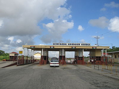
Demerara Harbour Bridge
Encyclopedia
Pontoon bridge
A pontoon bridge or floating bridge is a bridge that floats on water and in which barge- or boat-like pontoons support the bridge deck and its dynamic loads. While pontoon bridges are usually temporary structures, some are used for long periods of time...
. It was commissioned on 2 July 1978. The bridge crosses the Demerara River
Demerara River
The Demerara River is a river in eastern Guyana that rises in the central rainforests of the country and flows to the north for 346 kilometres until it reaches the Atlantic Ocean. Georgetown, Guyana's largest seaport and capital, is situated on the east bank of the river's mouth. The Demerara's...
4 miles (6.4 km) south of the Guyanese
Guyana
Guyana , officially the Co-operative Republic of Guyana, previously the colony of British Guiana, is a sovereign state on the northern coast of South America that is culturally part of the Anglophone Caribbean. Guyana was a former colony of the Dutch and of the British...
capital Georgetown
Georgetown, Guyana
Georgetown, estimated population 239,227 , is the capital and largest city of Guyana, located in the Demerara-Mahaica region. It is situated on the Atlantic Ocean coast at the mouth of the Demerara River and it was nicknamed 'Garden City of the Caribbean.' Georgetown is located at . The city serves...
, from Peter's Hall, East Bank Demerara to Schoon Ord, West Bank Demerara. There is a pedestrian footwalk. A raised section lets small vessels pass under. A retractor span lets large vessels pass. Construction of the Demerara Harbour Bridge began on 29 May 1976. Construction assistance was provided by the British Government. Toll is collected only in one direction of travel even though the bridge handles one lane of traffic in each direction. Traffic going west to east pays no toll.
The bridge is approximately 1.25 miles (2 km) long and has 61 spans. A high-level span provides a horizontal clearance of 32.0 metres (105 ft) and a vertical clearance of 7.9 metres (26 ft) to let small craft pass at all times. To let large craft pass, two retractor spans retract fully to leave a horizontal clearance of 77.4 metres (254 ft).
History
The expanding country needed a way to transport and link its people. Most of the country's population lives within 80 miles (128.7 km) of Georgetown and it is important to link these people together. The only thing keeping Georgetown apart from West Bank Demerara was the Demerara River. The government decided to construct a floating bridge to accommodate growing business and trade across Guyana.The bridge is a local project proposed by sea-captain John Cogland and designed by Joseph Holderhttp://www.landofsixpeoples.com/news303/ns3072213.htm.