

Delhi-Gurgaon Expressway
Encyclopedia
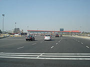
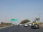
Delhi-Gurgaon Expressway is a 28 km (17.4 mi) long access-controlled toll expressway connecting Delhi
, the national capital of India, and Gurgaon
, an important satellite city of Haryana
.
The expressway is a part of the Golden Quadrilateral
project, which itself is a part of the National Highway Development Project (NHDP) and emphasizes improving road connectivity between four metropolitan cities of India, namely Delhi, Mumbai
, Chennai
and Kolkata
by developing 4–6 lane highways between them.
The much-delayed , 27.7 km (17.2 mi) expressway was thrown open on January 23, 2008. It has helped reduce the travel time of hundreds of thousands of commuters and international air passengers. Vehicle users have to pay a toll for using the expressway, which is collected at three points, near the Indira Gandhi International Airport, the Delhi-Gurgaon Border and the 42nd Milestone.
Since it began operation, it has also achieved notoriety for a large number of accidents involving pedestrians. There are only two overbridges along the entire stretch to cater to the communities living on either side of heavily populated areas through which the expressway runs. The toll plaza at the Delhi-Gurgaon border has also proved inadequate to handle the increasing traffic, leading to traffic jams during peak hours. Though the plaza is tag enabled, only 40 percent of the traffic that passes through avails of this facility.
 This expressway is the busiest inter-city route in India and handles more than 180,000 PCUs daily.
Delhi
Delhi , officially National Capital Territory of Delhi , is the largest metropolis by area and the second-largest by population in India, next to Mumbai. It is the eighth largest metropolis in the world by population with 16,753,265 inhabitants in the Territory at the 2011 Census...
, the national capital of India, and Gurgaon
Gurgaon
Gurgaon is the second largest city in the Indian state of Haryana. Gurgaon is the industrial and financial center of Haryana. It is located 30 km south of national capital New Delhi, about 10 kilometers from Dwarka Sub City and 268 km south of Chandigarh, the state capital...
, an important satellite city of Haryana
Haryana
Haryana is a state in India. Historically, it has been a part of the Kuru region in North India. The name Haryana is found mentioned in the 12th century AD by the apabhramsha writer Vibudh Shridhar . It is bordered by Punjab and Himachal Pradesh to the north, and by Rajasthan to the west and south...
.
The expressway is a part of the Golden Quadrilateral
Golden Quadrilateral
The Golden Quadrilateral is a highway network connecting India's four largest metropolises: Delhi, Mumbai, Chennai and Kolkata, thus forming a quadrilateral of sorts. Four other top ten metropolises: Bangalore, Pune, Ahmedabad, and Surat, are also served by the network...
project, which itself is a part of the National Highway Development Project (NHDP) and emphasizes improving road connectivity between four metropolitan cities of India, namely Delhi, Mumbai
Mumbai
Mumbai , formerly known as Bombay in English, is the capital of the Indian state of Maharashtra. It is the most populous city in India, and the fourth most populous city in the world, with a total metropolitan area population of approximately 20.5 million...
, Chennai
Chennai
Chennai , formerly known as Madras or Madarasapatinam , is the capital city of the Indian state of Tamil Nadu, located on the Coromandel Coast off the Bay of Bengal. Chennai is the fourth most populous metropolitan area and the sixth most populous city in India...
and Kolkata
Kolkata
Kolkata , formerly known as Calcutta, is the capital of the Indian state of West Bengal. Located on the east bank of the Hooghly River, it was the commercial capital of East India...
by developing 4–6 lane highways between them.
The much-delayed , 27.7 km (17.2 mi) expressway was thrown open on January 23, 2008. It has helped reduce the travel time of hundreds of thousands of commuters and international air passengers. Vehicle users have to pay a toll for using the expressway, which is collected at three points, near the Indira Gandhi International Airport, the Delhi-Gurgaon Border and the 42nd Milestone.
Since it began operation, it has also achieved notoriety for a large number of accidents involving pedestrians. There are only two overbridges along the entire stretch to cater to the communities living on either side of heavily populated areas through which the expressway runs. The toll plaza at the Delhi-Gurgaon border has also proved inadequate to handle the increasing traffic, leading to traffic jams during peak hours. Though the plaza is tag enabled, only 40 percent of the traffic that passes through avails of this facility.
Special features
- Starts at Dhaula KuanDhaula KuanDhaula Kuan is a major intersection of roads in Delhi, India. The name also now refers to the neighborhood surrounding the intersection. It lies in South West Delhi.-Intersection:Five major throughfares in Delhi meet at Dhaula Kuan...
in DelhiDelhiDelhi , officially National Capital Territory of Delhi , is the largest metropolis by area and the second-largest by population in India, next to Mumbai. It is the eighth largest metropolis in the world by population with 16,753,265 inhabitants in the Territory at the 2011 Census...
and terminates on the outskirts of GurgaonGurgaonGurgaon is the second largest city in the Indian state of Haryana. Gurgaon is the industrial and financial center of Haryana. It is located 30 km south of national capital New Delhi, about 10 kilometers from Dwarka Sub City and 268 km south of Chandigarh, the state capital...
(ManesarManesarManesar/मानेसर is a fast growing industrial town in Gurgaon district of the State of Haryana in India, and is a part of the National Capital Region of Delhi. It has transformed from a sleepy village to one of the fastest growing townships in India. It is an upcoming area of NCR. Some of the...
). - The road has 11 flyovers and overpasses.
- Four toll plazas including the 36-lane toll plaza at Delhi-Haryana Border, which is the biggest toll plaza in South Asia and the second biggest in the Asia.
- CCTV surveillance till IGI airportIndira Gandhi International AirportIndira Gandhi International Airport is the primary international airport of the National Capital Region of Delhi, India, situated in West Delhi, 16 km southwest of New Delhi city centre. Named after Indira Gandhi, the former Prime Minister of India, it is the busiest airport in India in...
. - SOS one-way telephones at every 1.5 km (0.93205910497471 mi)
- Elevated sections of the expressway will be open only for vehicles capable of attaining speeds of 80–100 km/h. of service roads for local and slow moving traffic.
Authorities involved
- Delhi Development AuthorityDelhi Development AuthorityThe Delhi Development Authority was created in 1955 under the provisions of the Delhi Development Act "to promote and secure the development of Delhi".-History:...
(DDA) - Haryana Urban Development Authority (HUDA)
- National Highways Authority of IndiaNational Highways Authority of IndiaThe National Highways Authority of India is an autonomous agency of the Government of India, responsible for management of a network of over 60,000 km of National Highways in India...
(NHAI) - Central Road Research Institute (CRRI)
See also
- Expressways in IndiaExpressway (India)An expressway is a controlled-access highway; it is a highway that controls entrances to it and exits from it by incorporating the design of the slip roads for entry and exit into the design of the highway itself. Access-control should not be confused with collection of toll. An expressway may be...
- List of National Highways in India by highway number
- Highways passing from DelhiHighways passing from DelhiDelhi, a major metropolitan region of India, is connected to various parts of country through several national highways. Most of the highways from Delhi lead to Haryana or Uttar Pradesh and continue from there...
- Indian HighwaysIndian highwaysThe National Highways Network of India, is a network of highways that is managed and maintained by agencies of the Government of India. These highways measured over as of 2010, including over of limited-access Expressways....
- National Highways Development ProjectNational Highways Development ProjectThe National Highways Development Project is a project to upgrade, rehabilitate and widen major highways in India to a higher standard. The project was implemented in 1998. "National Highways" account for only about 2% of the total length of roads, but carry about 40% of the total traffic across...
- DND FlywayDND FlywayDND Flyway is an eight-laned access controlled tolled expressway which connects Delhi to Noida, an industrial suburb area. It was built and is maintained by The Noida Toll Bridge Company Ltd. The acronym DND stands for "Delhi-Noida Direct".-Construction:The project, built by the Noida Toll Bridge...