

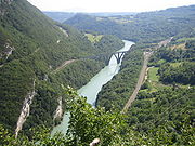
Defile (geography)
Encyclopedia
Geography
Geography is the science that studies the lands, features, inhabitants, and phenomena of Earth. A literal translation would be "to describe or write about the Earth". The first person to use the word "geography" was Eratosthenes...
term for a narrow pass or gorge between mountains or hills. It has its origins as a military description of a pass through which troops can march only in a narrow column
Column (formation)
A military column is a formation of soldiers marching together in one or more files in which the file is significantly longer than the width of ranks in the formation...
or with a narrow front. On emerging from a defile (or something similar) into open country, soldiers are said to "debouch
Debouch
Debouch is a term used in river and stream geography, and the military.-Geography:In fluvial geography, a debouch is a place where a body of water pours forth from a narrow opening...
".
In a traditional military formation soldiers march in rank
Rank (formation)
A Rank is a line of military personnel, drawn up in line abreast .Commonly, troops called to 'On the right, fall in!' do so by forming in line abreast, determining their initial position in relation to a marker. This may be a position on the ground or a single person placed previously to the movement...
(the depth of the formation) and file
File (formation)
A file is a military term for a number of troops drawn up in line ahead, i.e. one behind the other in a column. The number of files is the measure of the width of a formation of troops in several ranks one behind the other.- Ancient Greek use :...
s (the width of the formation), so if a column of soldiers approach a narrow pass the formation must narrow which means that files on the outside must be ordered to the rear (or to some other position) so that the column has fewer files and more ranks. The French
French language
French is a Romance language spoken as a first language in France, the Romandy region in Switzerland, Wallonia and Brussels in Belgium, Monaco, the regions of Quebec and Acadia in Canada, and by various communities elsewhere. Second-language speakers of French are distributed throughout many parts...
verb for this order is défilé, from which the English
English language
English is a West Germanic language that arose in the Anglo-Saxon kingdoms of England and spread into what was to become south-east Scotland under the influence of the Anglian medieval kingdom of Northumbria...
verb comes, as does the physical description for a valley that forces this manoeuvre.
Defiles of military significance can also be formed by other physical features that flank a pass or path and cause it to narrow, for example impassable woods and rivers. At the Battle of Agincourt
Battle of Agincourt
The Battle of Agincourt was a major English victory against a numerically superior French army in the Hundred Years' War. The battle occurred on Friday, 25 October 1415 , near modern-day Azincourt, in northern France...
a defile formed by the woods of Agincourt and Tramecourt caused a choke point
Choke point
In military strategy, a choke point is a geographical feature on land such as a valley, defile or a bridge, or at sea such as a strait which an armed force is forced to pass, sometimes on a substantially narrower front, and therefore greatly decreasing its combat power, in order to reach its...
for the French army and aided the English in their victory over the French.
Some defiles have a permanent strategic importance and become known by that term in military literature. For example the military historian William Siborne
William Siborne
William Siborne, Sibourne or Siborn was a British officer and military historian whose most notable work was a history of the Waterloo campaign.-Early life:...
names such a geographic feature in France near the frontier with Germany in his book Waterloo Campaign 1815:
See also
- CanyonCanyonA canyon or gorge is a deep ravine between cliffs often carved from the landscape by a river. Rivers have a natural tendency to reach a baseline elevation, which is the same elevation as the body of water it will eventually drain into. This forms a canyon. Most canyons were formed by a process of...
- Draw (terrain)Draw (terrain)A draw a terrain feature formed by two parallel ridges or spurs with low ground in between them. The area of low ground itself is the draw, and it is defined by the spurs surrounding it...
- GullyGullyA gully is a landform created by running water, eroding sharply into soil, typically on a hillside. Gullies resemble large ditches or small valleys, but are metres to tens of metres in depth and width...
- RavineRavineA ravine is a landform narrower than a canyon and is often the product of streamcutting erosion. Ravines are typically classified as larger in scale than gullies, although smaller than valleys. A ravine is generally a fluvial slope landform of relatively steep sides, on the order of twenty to...
- ValleyValleyIn geology, a valley or dale is a depression with predominant extent in one direction. A very deep river valley may be called a canyon or gorge.The terms U-shaped and V-shaped are descriptive terms of geography to characterize the form of valleys...
- Water gapWater gapA water gap is an opening or notch which flowing water has carved through a mountain range. Water gaps often offer a practical route for road and rail transport to cross mountain ridges.- Geology :...
- Wind gapWind gapA wind gap is a valley through which a waterway once flowed, but is now dry as a result of stream capture. A water gap is a similar feature, but one in which a waterway still flows...