
Dead Man's Curve
Encyclopedia
Cleveland Innerbelt
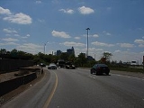
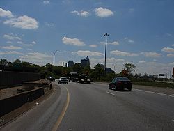
One such curve is the nearly 90-degree turn on Interstate 90Interstate 90
Interstate 90 is the longest Interstate Highway in the United States at . It is the northernmost coast-to-coast interstate, and parallels US 20 for the most part. Its western terminus is in Seattle, at Edgar Martinez Drive S. near Safeco Field and CenturyLink Field, and its eastern terminus is in...
near downtown Cleveland, Ohio
Cleveland, Ohio
Cleveland is a city in the U.S. state of Ohio and is the county seat of Cuyahoga County, the most populous county in the state. The city is located in northeastern Ohio on the southern shore of Lake Erie, approximately west of the Pennsylvania border...
, officially the Innerbelt Curve, at the point where the Cleveland Memorial Shoreway
Cleveland Memorial Shoreway
The Cleveland Memorial Shoreway is a limited-access freeway in Cleveland, Ohio. It closely follows the shore of Lake Erie and connects the east and west sides of Cleveland via the Main Avenue Bridge. The Shoreway carries State Route 2 along its length, and also carries U.S. 6, U.S. 20 and I-90...
connects to the Innerbelt Freeway
Innerbelt Freeway
An Innerbelt Freeway is a set of freeway facilities arranged in a loop that serves the interior of a major city, primarily as a traffic reliever for downtown commuters...
just south of Burke Lakefront Airport. The advisory speed is 35 miles per hour (60 kilometers per hour), although the maximum safe speed limit
Speed limit
Road speed limits are used in most countries to regulate the speed of road vehicles. Speed limits may define maximum , minimum or no speed limit and are normally indicated using a traffic sign...
is 50 mph (80 km/h), as on adjacent sections of the Shoreway and Innerbelt.
Dead Man's Curve was constructed as part of the Innerbelt project in 1959. It soon became apparent that the curve was too sharp for travel at typical Interstate speeds, and in 1965, the state lowered the speed limit from 50 mi/h to 35 mi/h. Four years later, authorities completed the first set of safety retrofits, which included banking
Banked turn
A banked turn is a turn or change of direction in which the vehicle banks or inclines, usually towards the inside of the turn. The bank angle is the angle at which the vehicle is inclined about its longitudinal axis with respect to its path....
the curve and installing rumble strip
Rumble strip
Rumble strips, also known as sleeper lines, are a road safety feature that alert inattentive drivers to potential danger by causing a tactile vibration and audible rumbling, transmitted through the wheels into the car body...
s and large signs.
According to the Ohio Department of Transportation
Ohio Department of Transportation
The Ohio Department of Transportation is the organization of state government responsible for developing and maintaining all state and federal roadways in the state of Ohio with exception of the Ohio Turnpike. In addition to highways, the department also helps develop public transportation and...
(ODOT), the crash rate on the Innerbelt (which includes Dead Man's Curve) is two to three times the regional average for urban freeways, despite the reduced speed limits on the roadway. The department is investigating ways of enhancing safety on the stretch, including a complete realignment of the roadway to reduce the degree of the curve. According to a 2003 ODOT count, 95,090 vehicles travel on the curve every day.
The official ODOT name for the curve is the Innerbelt Curve, but the nickname "Dead Man's Curve" is commonly used colloquially and in traffic reports.
According to the Innerbelt Reconstruction Plan, Dead Man's Curve will eventually be softened.
Other sharp curves
Other roads and highways have sections known as Dead Man's Curve:- A sharp turn in the shape of a "U" on SR 76 in San Diego County, California, near Red Gate Road. This curve has claimed the lives of many motocyclists.
- A stretch of Sunset BoulevardSunset BoulevardSunset Boulevard is a street in the western part of Los Angeles County, California, that stretches from Figueroa Street in downtown Los Angeles to the Pacific Coast Highway at the Pacific Ocean in the Pacific Palisades...
in Los Angeles, CaliforniaLos Angeles, CaliforniaLos Angeles , with a population at the 2010 United States Census of 3,792,621, is the most populous city in California, USA and the second most populous in the United States, after New York City. It has an area of , and is located in Southern California...
was immortalized by Jan and DeanJan and DeanJan and Dean were a rock and roll duo, popular from the late 1950s through the mid 1960s, consisting of William Jan Berry and Dean Ormsby Torrence...
in the song "Dead Man's CurveDead Man's Curve (song)"Dead Man's Curve" is a 1964 hit song by Jan and Dean detailing a teen street race gone awry. It reached number eight on the Billboard Hot 100 singles chart....
." It is located near the Bel Air estates just north of UCLA's Drake Stadium. - Interstate 83Interstate 83Interstate 83 is an Interstate Highway in the eastern United States. Its southern terminus is in Baltimore, Maryland at the Fayette Street exit; its northern terminus is in Harrisburg, Pennsylvania at Interstate 81....
(Jones Falls Expressway) in Baltimore, MD, - Interstate 20Interstate 20Interstate 20 is a major east–west Interstate Highway in the Southern United States. I‑20 runs 1,535 miles from near Kent, Texas, at Interstate 10 to Florence, South Carolina, at Interstate 95...
just east of the Birmingham, AlabamaBirmingham, AlabamaBirmingham is the largest city in Alabama. The city is the county seat of Jefferson County. According to the 2010 United States Census, Birmingham had a population of 212,237. The Birmingham-Hoover Metropolitan Area, in estimate by the U.S...
airportBirmingham International Airport (US)Southwest Airlines carried the most passengers through BHM in 2007; transporting 1.14 million passengers, 35.6% of total BHM passengers. Additionally, Southwest Airlines operates BHM as a connecting airport for over 180 different flight pairs.Southwest uses Las Vegas and Phoenix to connect...
, at its junction with Interstate 59Interstate 59Interstate 59 is an Interstate Highway in the southern United States. Its southern terminus is near Slidell, Louisiana, a suburb of New Orleans, at an intersection with Interstate 10 and Interstate 12, its northern terminus is at Wildwood, Georgia, at an intersection with Interstate 24.The road's...
; engineers were forced to build a curve into the highway to avoid a cemeteryCemeteryA cemetery is a place in which dead bodies and cremated remains are buried. The term "cemetery" implies that the land is specifically designated as a burying ground. Cemeteries in the Western world are where the final ceremonies of death are observed...
. - Interstate 59Interstate 59Interstate 59 is an Interstate Highway in the southern United States. Its southern terminus is near Slidell, Louisiana, a suburb of New Orleans, at an intersection with Interstate 10 and Interstate 12, its northern terminus is at Wildwood, Georgia, at an intersection with Interstate 24.The road's...
about 10 miles north of Gadsden, AlabamaGadsden, AlabamaThe city of Gadsden is the county seat of Etowah County in the U.S. state of Alabama, and it is located about 65 miles northeast of Birmingham, Alabama. It is the primary city of the Gadsden Metropolitan Statistical Area, which has a population of 103,459. Gadsden is closely associated with the...
. The s-shaped had to be built to avoid running straight up in to a steep mountain. - A sharp turn in a series of sharp bends on Kali Oka Road, located in Saraland, AlabamaSaraland, AlabamaSaraland is a city in Mobile County, Alabama, in the United States, and a suburb of Mobile, Alabama. As of the 2010 census, the population of the city is 13,405. It is a part of the Mobile metropolitan area. Saraland is the third largest city in Mobile County....
just south of a Crybaby BridgeCrybaby BridgeCrybaby Bridge is a nickname given to some bridges. The name often reflects an urban legend that the sound of a baby can be, or has been, heard from the bridge...
. - A sharp bend in U.S. Route 50U.S. Route 50U.S. Route 50 is a major east–west route of the U.S. Highway system, stretching just over from Ocean City, Maryland on the Atlantic Ocean to West Sacramento, California. Until 1972, when it was replaced by Interstate Highways west of the Sacramento area, it extended to San Francisco, near...
(Columbia Parkway) east of Cincinnati, OhioCincinnati, OhioCincinnati is a city in the U.S. state of Ohio. Cincinnati is the county seat of Hamilton County. Settled in 1788, the city is located to north of the Ohio River at the Ohio-Kentucky border, near Indiana. The population within city limits is 296,943 according to the 2010 census, making it Ohio's...
. - A sharp turn on eastbound Interstate 70Interstate 70Interstate 70 is an Interstate Highway in the United States that runs from Interstate 15 near Cove Fort, Utah, to a Park and Ride near Baltimore, Maryland. It was the first Interstate Highway project in the United States. I-70 approximately traces the path of U.S. Route 40 east of the Rocky...
near Morrison, ColoradoMorrison, ColoradoThe historic Town of Morrison is a Home Rule Municipality in Jefferson County, Colorado, United States. The population was 430 at the 2000 census...
that is preceded by a seven mile (11 km) stretch of a 6.5% grade hill, which has been the site of numerous fatal runaway truck accidents. - A treacherously sharp turn at the end of Kapaa Quary Road, a dimly lit utility road in Kailua, Oahu HI. It has already claimed eight fatalities and is considered one of Oahu's haunted roads. http://www.hauntedhawaii.net/ghost_hunting___3.170.html#Ghost%20Hunting%20-%203 http://www1.honolulu.gov/refs/nco/nb31/08/31febmin.htm
- A treacherous stretch of Interstate 75 in Northern KentuckyNorthern KentuckyNorthern Kentucky is the name often given to the northernmost counties in Kentucky...
originally known as "Death Hill" and now known as "Cut-in-the-HillCut-in-the-HillCut-in-the-Hill is a stretch of I-75 highway located in Covington, Kentucky between Buttermilk Pike and the Brent Spence Bridge near Cincinnati, Ohio. The hill is known for its large number of automobile accidents...
". - A sharp, sudden turn on U.S. Route 175U.S. Route 175U.S. Highway 175 is an east-west United States highway, its span completely within the state of Texas. It comes very close to meeting its "parent", US 75, but decommissioning and rerouting in downtown Dallas, Texas bring it a couple of miles short. Before the decommissioning of US 75 south of...
(C. F. Hawn Freeway) at the interchange with SH 310 southeast of downtown Dallas, TexasDallas, TexasDallas is the third-largest city in Texas and the ninth-largest in the United States. The Dallas-Fort Worth Metroplex is the largest metropolitan area in the South and fourth-largest metropolitan area in the United States...
. After a fatal truck accident in 2008, TxDOT installed additional beacons and also flashing chevrons to further draw motorists' attention to the hazard at this location. As of 2010, TxDOT is studying plans to eliminate this curve by extending the C. F. Hawn Freeway westward to Interstate 45. - Sharp turn on Interstate 75Interstate 75Interstate 75 is a major north–south Interstate Highway in the Great Lakes and Southeastern regions of the United States. It travels from State Road 826 and State Road 924 in Hialeah, Florida to Sault Ste. Marie, Michigan, at the Ontario, Canada, border...
just north of downtown Dayton, OhioDayton, OhioDayton is the 6th largest city in the U.S. state of Ohio and the county seat of Montgomery County, the fifth most populous county in the state. The population was 141,527 at the 2010 census. The Dayton Metropolitan Statistical Area had a population of 841,502 in the 2010 census...
. - Sharp turn on Missouri State Route 34 just east of Garwood, Missouri in Reynolds CountyReynolds County, MissouriReynolds County is a county located in the northwestern portion of the Ozark Foothills Region in Southeast Missouri in the United States. As of the 2000 U.S. Census, the county's population was 6,689. A 2008 estimate, however, showed the population to be 6,388. Its county seat is Centerville...
. - A sharp 90-degree turn on New York State Route 17New York State Route 17New York State Route 17 is a state highway that extends for through the Southern Tier and Downstate regions of New York in the United States...
in Binghamton, New YorkBinghamton, New YorkBinghamton is a city in the Southern Tier of New York in the United States. It is near the Pennsylvania border, in a bowl-shaped valley at the confluence of the Susquehanna and Chenango Rivers...
, near the junction of the highway with Interstate 81Interstate 81Interstate 81 is an Interstate Highway in the eastern part of the United States. Its southern terminus is at Interstate 40 in Dandridge, Tennessee; its northern terminus is on Wellesley Island at the Canadian border, where the Thousand Islands Bridge connects it to Highway 401, the main freeway...
and Interstate 88Interstate 88 (east)Interstate 88 is an intrastate Interstate Highway entirely within the U.S. state of New York. Its western end is at Interstate 81 in Binghamton and its eastern end is at Interstate 90 in Schenectady. It serves as an important connector route from Albany to Binghamton, Elmira , and...
, also goes by the name KamikazeKamikazeThe were suicide attacks by military aviators from the Empire of Japan against Allied naval vessels in the closing stages of the Pacific campaign of World War II, designed to destroy as many warships as possible....
Curve. The tight curve, which hugs Prospect Mountain along the Chenango RiverChenango RiverThe Chenango River is a tributary of the Susquehanna River in central New York in the United States. It drains a dissected plateau area in upstate New York at the northern end of the Susquehanna watershed....
, is slated for improvements as part of NY 17's upgrade to Interstate 86Interstate 86 (east)Interstate 86 is an Interstate Highway that extends for through northwestern Pennsylvania and southern New York in the United States...
.
- A temporary S-shape curve on the Eastern span of the San Francisco–Oakland Bay Bridge (part of Interstate 80Interstate 80Interstate 80 is the second-longest Interstate Highway in the United States, following Interstate 90. It is a transcontinental artery running from downtown San Francisco, California to Teaneck, New Jersey in the New York City Metropolitan Area...
). Since its installation on September 8, 2009, to divert traffic as part of the replacement project, 43 accidents have occurred, including 1 fatal crash. - On the Mount Hood Scenic Byway between ZigzagZigzag, OregonZigzag is an unincorporated community in Clackamas County, Oregon, United States. It is located within the Mount Hood Corridor, between Rhododendron and Welches on U.S. Route 26...
and Government CampGovernment Camp, OregonGovernment Camp is an unincorporated community located in Clackamas County, Oregon, United States, south of Mount Hood and north of Tom, Dick and Harry Mountain. It is a gateway to several ski resorts, the most popular being Timberline Lodge and Mount Hood Skibowl. Also, Government Camp has its... - The northern terminus of Interstate 476Interstate 476Interstate 476 is a auxiliary Interstate Highway in the U.S. state of Pennsylvania designated between Interstate 95 near Chester and Interstate 81 near Scranton, serving as the primary north–south Interstate corridor through eastern Pennsylvania....
in Clarks Summit, PennsylvaniaClarks Summit, PennsylvaniaClarks Summit is a borough in Lackawanna County northwest of Scranton in northeastern Pennsylvania, United States. The population was 5,116 at the 2010 census. It is also the northern terminus of the Pennsylvania Turnpike Northeast Extension, I-476.-History:...
is a 180-degree turn, with an advisory speed limit of 20 mph, created in order to access a toll plaza before interchanging with Interstate 81Interstate 81Interstate 81 is an Interstate Highway in the eastern part of the United States. Its southern terminus is at Interstate 40 in Dandridge, Tennessee; its northern terminus is on Wellesley Island at the Canadian border, where the Thousand Islands Bridge connects it to Highway 401, the main freeway...
. - In Marquette Township, Marquette County, MichiganMarquette Township, Marquette County, MichiganMarquette Charter Township is a charter township of Marquette County in the U.S. state of Michigan. The population was 3,286 at the 2000 census...
, Dead Man's Curve referred to a curve on M-15M-15 (Michigan highway)M-15 is a north–south state trunkline highway in the US state of Michigan. The southern terminus is a junction with US Highway 24 just south of Clarkston on the northwestern edge of the Detroit metropolitan area. The trunkline is a recreational route running north and northwest to the...
(now a former section of County Road 492County Road 492 (Marquette County, Michigan)County Road 492 is a primary county road in Marquette County, Michigan. The road serves as an alternate route between Negaunee and Marquette. Several historic sites line the roadway as it runs south and parallel to the main highway, U.S. Highway 41 through the Marquette Range in Michigan's Upper...
) where the first center stripeRoad surface markingRoad surface marking is any kind of device or material that is used on a road surface in order to convey official information. They can also be applied in other facilities used by vehicles to mark parking spaces or designate areas for other uses....
in the United States was painted.46.5318°N 87.474°W - On U.S. Route 22U.S. Route 22U.S. Route 22 is a west–east route and is one of the original United States highways of 1926, running from Cincinnati, Ohio, at US 27, US 42, US 127, and US 52 to Newark, New Jersey, at U.S. Route 1/9 near the Newark Liberty International Airport.US 22 also carries the names of the William...
in Easton, PennsylvaniaEaston, PennsylvaniaEaston is a city in Northampton County, Pennsylvania, United States. The population was 26,800 as of the 2010 census. It is the county seat of Northampton County....
, there are several dangerous sharp turns that go past a graveyard. (This is most commonly known as "Cemetery Curve" for that reason.) Streetlights were installed to help cut down on nighttime crashes; the lightposts are themselves frequent victims of collisions. - In northern Bossier Parish, Louisiana, a sharp curve on Louisiana 157 (Hickory Drive) just inside the city limits of Plain Dealing, LouisianaPlain Dealing, LouisianaPlain Dealing is a town in Bossier Parish, Louisiana, United States best known as the birthplace of former U.S. Representative Joe D. Waggonner, Jr. The population was 1,071 at the 2000 census...
south of the town cemetery. - In IndianapolisIndianapolisIndianapolis is the capital of the U.S. state of Indiana, and the county seat of Marion County, Indiana. As of the 2010 United States Census, the city's population is 839,489. It is by far Indiana's largest city and, as of the 2010 U.S...
, Indiana, a curve on Interstate 70 west bound at mile marker 83.1 When originally opened, it had a negative bank on the right shoulder and several truckers lost control and impacted the following bridge abutment, losing their lives. The new stretch was closed, re-engineered with a positive bank and rain slots along the boundary, and reopened with a 40MPH speed limit.
External links
- Encyclopedia of Cleveland History — Innerbelt Freeway
- Cleveland Innerbelt Plan (Ohio Department of TransportationOhio Department of TransportationThe Ohio Department of Transportation is the organization of state government responsible for developing and maintaining all state and federal roadways in the state of Ohio with exception of the Ohio Turnpike. In addition to highways, the department also helps develop public transportation and...
) - Pictures of downtown Cleveland roads, including Dead Man's Curve
- ODOT traffic counts
- Video of Dead Man's Curve westbound (0:44)
- Snopes.com page regarding the Los Angeles curve